The IP30 9 postcode sector is within the county of Suffolk.
Did you know? According to the 2021 Census, the IP30 9 postcode sector is home to a bustling 9,976 residents!
Given that each sector allows for 400 unique postcode combinations. Letters C, I, K, M, O and V are not allowed in the last two letters of a postcode. With 314 postcodes already in use, this leaves 86 units available.
The largest settlement in the IP30 9 postal code is Elmswell followed by Woolpit, and Rougham.
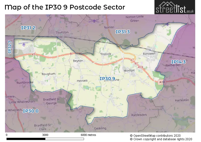
The IP30 9 Postcode shares a border with IP30 0 (Cockfield, Rattlesden, Great Whelnetham), IP31 2 (Stanton, Great Barton, Ixworth), IP31 3 (Thurston, Walsham-le-Willows, Norton), IP32 7 (BURY ST. EDMUNDS) and IP14 3 (Haughley, Great Finborough, Onehouse).
The sector is within the post town of BURY ST. EDMUNDS.
IP30 9 is a postcode sector within the IP30 postcode district which is within the IP Ipswich postcode area.
The Royal Mail delivery office for the IP30 9 postal sector is the Bury St. Edmunds Delivery Office and Elmswell Scale Payment Delivery Office and Woolpit Scale Payment Delivery Office.
The area of the IP30 9 postcode sector is 20.47 square miles which is 53.01 square kilometres or 13,099.69 square acres.
The IP30 9 postcode sector is crossed by the A14 Major A road.

Map of the IP30 9 Postcode Sector
Explore the IP30 9 postcode sector by using our free interactive map.
| I | P | 3 | 0 | - | 9 | X | X |
| I | P | 3 | 0 | Space | 9 | Letter | Letter |
Official List of Streets
Woolpit (57 Streets)
Rougham (31 Streets)
Tostock (17 Streets)
Elmswell (85 Streets)
Beyton (16 Streets)
Hessett (15 Streets)
Drinkstone (16 Streets)
Unofficial Streets or Alternative Spellings
Elmswell
WHITE HOUSE BARNS BRICKFIELDS BUSINESS PARK BUNKERS DIP CLAYPIT CLOSE DEBEN BUSINESS PARK DROVE LANE EASTLOW HILL EASTLOWHILL ROAD ELMTREE BUSINESS PARK FARM MEADOW FELDWAY FOUR WHEEL DRIVE FRED CASTLE WAY GENERAL CASTLE WAY HUBBARD STUD LADY MIRIAM WAY LINKWOOD ROAD LUNDY COURT MANOR FARM MANOR ROAD MAXWELL ROAD MEADOW VIEW MERLIN WAY MOORE ROAD OLSEN ROAD PAIGLES CLOSE PARNELL LANE PERKINS ROAD PORTMAN LOGISTICS YARD PRIGMORE DRIVE ROOKERY CROSSROADS ROUNDABOUT RUBIN CLOSE SALTSMAN ROAD SHARPES ROW SOW LANE THE GARDENS VENTURE ROAD WHORTON AVENUE WILLIS STREET WOOD LANE WOODLANDS ROAD WOOLPIT INTERCHANGERattlesden
FELSHAM ROADBeyton
FALLOWFIELDThurston
BEYTON ROAD HOLLOW LANE PEPPER LANE THE PLANCHEBURY ST. EDMUNDS
ROUGHAM TOWER AVENUE SHACKEROO ROADRougham
REED PLACEWeather Forecast for IP30 9
Press Button to Show Forecast for Maypole Green
| Time Period | Icon | Description | Temperature | Rain Probability | Wind |
|---|---|---|---|---|---|
| 00:00 to 03:00 | Cloudy | 4.0°C (feels like 1.0°C) | 11.00% | NNW 9 mph | |
| 03:00 to 06:00 | Cloudy | 3.0°C (feels like 0.0°C) | 7.00% | NW 11 mph | |
| 06:00 to 09:00 | Cloudy | 4.0°C (feels like 0.0°C) | 5.00% | NW 11 mph | |
| 09:00 to 12:00 | Cloudy | 7.0°C (feels like 3.0°C) | 33.00% | NNW 13 mph | |
| 12:00 to 15:00 | Cloudy | 8.0°C (feels like 5.0°C) | 5.00% | N 16 mph | |
| 15:00 to 18:00 | Cloudy | 9.0°C (feels like 5.0°C) | 4.00% | N 16 mph | |
| 18:00 to 21:00 | Cloudy | 7.0°C (feels like 4.0°C) | 3.00% | N 11 mph | |
| 21:00 to 00:00 | Cloudy | 4.0°C (feels like 2.0°C) | 4.00% | NNW 7 mph |
Press Button to Show Forecast for Maypole Green
| Time Period | Icon | Description | Temperature | Rain Probability | Wind |
|---|---|---|---|---|---|
| 00:00 to 03:00 | Cloudy | 4.0°C (feels like 1.0°C) | 7.00% | NNW 7 mph | |
| 03:00 to 06:00 | Overcast | 4.0°C (feels like 1.0°C) | 7.00% | NNW 7 mph | |
| 06:00 to 09:00 | Overcast | 5.0°C (feels like 2.0°C) | 9.00% | NNW 7 mph | |
| 09:00 to 12:00 | Overcast | 7.0°C (feels like 4.0°C) | 10.00% | N 13 mph | |
| 12:00 to 15:00 | Overcast | 9.0°C (feels like 6.0°C) | 11.00% | NNE 13 mph | |
| 15:00 to 18:00 | Overcast | 10.0°C (feels like 7.0°C) | 10.00% | NNE 11 mph | |
| 18:00 to 21:00 | Partly cloudy (day) | 8.0°C (feels like 5.0°C) | 3.00% | NNE 9 mph | |
| 21:00 to 00:00 | Cloudy | 5.0°C (feels like 3.0°C) | 5.00% | NNE 7 mph |
Press Button to Show Forecast for Maypole Green
| Time Period | Icon | Description | Temperature | Rain Probability | Wind |
|---|---|---|---|---|---|
| 00:00 to 03:00 | Clear night | 4.0°C (feels like 1.0°C) | 1.00% | N 7 mph | |
| 03:00 to 06:00 | Clear night | 3.0°C (feels like 0.0°C) | 2.00% | N 4 mph | |
| 06:00 to 09:00 | Cloudy | 4.0°C (feels like 2.0°C) | 5.00% | NNW 7 mph | |
| 09:00 to 12:00 | Cloudy | 8.0°C (feels like 6.0°C) | 7.00% | N 7 mph | |
| 12:00 to 15:00 | Overcast | 9.0°C (feels like 7.0°C) | 15.00% | N 9 mph | |
| 15:00 to 18:00 | Overcast | 9.0°C (feels like 7.0°C) | 18.00% | N 9 mph | |
| 18:00 to 21:00 | Overcast | 7.0°C (feels like 6.0°C) | 16.00% | NNW 7 mph | |
| 21:00 to 00:00 | Cloudy | 5.0°C (feels like 3.0°C) | 11.00% | NE 4 mph |
Press Button to Show Forecast for Maypole Green
| Time Period | Icon | Description | Temperature | Rain Probability | Wind |
|---|---|---|---|---|---|
| 00:00 to 03:00 | Cloudy | 4.0°C (feels like 2.0°C) | 10.00% | NNE 4 mph | |
| 03:00 to 06:00 | Light rain | 4.0°C (feels like 1.0°C) | 40.00% | WNW 4 mph | |
| 06:00 to 09:00 | Light rain shower (day) | 5.0°C (feels like 3.0°C) | 30.00% | N 4 mph | |
| 09:00 to 12:00 | Light rain | 8.0°C (feels like 6.0°C) | 40.00% | NNE 9 mph | |
| 12:00 to 15:00 | Light rain | 9.0°C (feels like 7.0°C) | 41.00% | NNE 9 mph | |
| 15:00 to 18:00 | Overcast | 9.0°C (feels like 7.0°C) | 19.00% | NNE 9 mph | |
| 18:00 to 21:00 | Cloudy | 8.0°C (feels like 6.0°C) | 6.00% | NNE 9 mph | |
| 21:00 to 00:00 | Cloudy | 6.0°C (feels like 3.0°C) | 13.00% | N 7 mph |
Schools and Places of Education Within the IP30 9 Postcode Sector
Elmswell Community Primary School
Community school
Oxer Close, Bury St Edmunds, Suffolk, IP30 9UE
Head: Mrs Jane Ash
Ofsted Rating: Good
Inspection: 2020-01-09 (1563 days ago)
Website: Visit Elmswell Community Primary School Website
Phone: 01359240261
Number of Pupils: 322
Rougham Church of England Primary School
Academy sponsor led
Church Road, Bury St. Edmunds, Suffolk, IP30 9JJ
Head: Mrs Clare Clark
Ofsted Rating: Requires improvement
Inspection: 2022-04-06 (745 days ago)
Website: Visit Rougham Church of England Primary School Website
Phone: 01359270288
Number of Pupils: 202
Woolpit Primary Academy
Academy converter
Heath Road, Bury St Edmunds, Suffolk, IP30 9RU
Head: Mrs Sarah Clayton
Ofsted Rating: Good
Inspection: 2022-07-13 (647 days ago)
Website: Visit Woolpit Primary Academy Website
Phone: 01359240625
Number of Pupils: 117
House Prices in the IP30 9 Postcode Sector
| Type of Property | 2018 Average | 2018 Sales | 2017 Average | 2017 Sales | 2016 Average | 2016 Sales | 2015 Average | 2015 Sales |
|---|---|---|---|---|---|---|---|---|
| Detached | £477,436 | 99 | £411,530 | 96 | £371,594 | 88 | £406,293 | 80 |
| Semi-Detached | £256,848 | 40 | £255,691 | 34 | £226,711 | 32 | £205,558 | 45 |
| Terraced | £221,936 | 49 | £211,500 | 31 | £190,673 | 26 | £176,074 | 27 |
| Flats | £101,500 | 2 | £146,000 | 2 | £131,250 | 8 | £152,000 | 1 |
Important Postcodes IP30 9 in the Postcode Sector
IP30 9AA is the postcode for Thurston Sixth Beyton Campus, Church Road, Beyton, Thurston Sixth Beyton Campus, Church Road, and Thurston High Annexe, Church Road
IP30 9JJ is the postcode for Rougham VA Primary School, Rougham
IP30 9QU is the postcode for Woolpit Health Centre, Heath Road, WOOLPIT HEALTH CENTRE PHARMACY, HEATH ROAD, WOOLPIT, and Woolpit Health Centre Pharmacy, Heath Road
IP30 9RU is the postcode for Woolpit Cp School, Heath Road
IP30 9UE is the postcode for ELMSWELL COMMUNITY PRIMARY SCHOOL, OXER CLOSE, ELMSWELL, Elmswell Community Primary School, Oxer Close, and 2, Oxer Close, Elmswell
| The IP30 9 Sector is within these Local Authorities |
|
|---|---|
| The IP30 9 Sector is within these Counties |
|
| The IP30 9 Sector is within these Water Company Areas |
|
Tourist Attractions within the IP30 9 Postcode Area
We found 1 visitor attractions within the IP30 postcode area
| The Control Tower Museum |
|---|
| Museums & Art Galleries |
| Museum and / or Art Gallery |
| View The Control Tower Museum on Google Maps |