The IP4 3 postcode sector is within the county of Suffolk.
Did you know? According to the 2021 Census, the IP4 3 postcode sector is home to a bustling 5,334 residents!
Given that each sector allows for 400 unique postcode combinations. Letters C, I, K, M, O and V are not allowed in the last two letters of a postcode. With 152 postcodes already in use, this leaves 248 units available.
The IP4 3 postal code covers the settlement of IPSWICH.
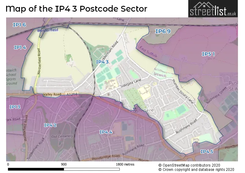
The IP4 3 Postcode shares a border with IP4 5 (IPSWICH, Rushmere St. Andrew), IP5 1 (Kesgrave, Rushmere St. Andrew), IP6 9 (Otley, Witnesham, Coddenham), IP1 4 (IPSWICH), IP1 6 (IPSWICH), IP4 2 (IPSWICH) and IP4 4 (IPSWICH).
The sector is within the post town of IPSWICH.
IP4 3 is a postcode sector within the IP4 postcode district which is within the IP Ipswich postcode area.
The Royal Mail delivery office for the IP4 3 postal sector is the Ipswich Delivery Office.
The area of the IP4 3 postcode sector is 1.29 square miles which is 3.34 square kilometres or 824.25 square acres.

Map of the IP4 3 Postcode Sector
Explore the IP4 3 postcode sector by using our free interactive map.
| I | P | 4 | - | 3 | X | X |
| I | P | 4 | Space | 3 | Letter | Letter |
Official List of Streets
IPSWICH (54 Streets)
Unofficial Streets or Alternative Spellings
IPSWICH
CEMETERY LANE PICTON AVENUERushmere St. Andrew
SEVEN COTTAGES LANEWesterfield
WESTERFIELD ROAD ABERDEEN WAY FONNEREAU WAY ORKNEY ROAD RUSHMERE STREETWeather Forecast for IP4 3
Press Button to Show Forecast for Ipswich
| Time Period | Icon | Description | Temperature | Rain Probability | Wind |
|---|---|---|---|---|---|
| 12:00 to 15:00 | Heavy rain | 7.0°C (feels like 6.0°C) | 84.00% | WNW 7 mph | |
| 15:00 to 18:00 | Cloudy | 8.0°C (feels like 5.0°C) | 50.00% | NNW 11 mph | |
| 18:00 to 21:00 | Cloudy | 8.0°C (feels like 5.0°C) | 4.00% | NNW 11 mph | |
| 21:00 to 00:00 | Overcast | 6.0°C (feels like 3.0°C) | 9.00% | NNW 9 mph |
Press Button to Show Forecast for Ipswich
| Time Period | Icon | Description | Temperature | Rain Probability | Wind |
|---|---|---|---|---|---|
| 00:00 to 03:00 | Cloudy | 5.0°C (feels like 2.0°C) | 7.00% | NW 9 mph | |
| 03:00 to 06:00 | Overcast | 5.0°C (feels like 1.0°C) | 7.00% | NW 11 mph | |
| 06:00 to 09:00 | Cloudy | 5.0°C (feels like 1.0°C) | 7.00% | NW 11 mph | |
| 09:00 to 12:00 | Overcast | 7.0°C (feels like 3.0°C) | 13.00% | NNW 13 mph | |
| 12:00 to 15:00 | Cloudy | 8.0°C (feels like 4.0°C) | 47.00% | NNW 16 mph | |
| 15:00 to 18:00 | Cloudy | 9.0°C (feels like 6.0°C) | 5.00% | NNW 16 mph | |
| 18:00 to 21:00 | Cloudy | 8.0°C (feels like 5.0°C) | 3.00% | N 11 mph | |
| 21:00 to 00:00 | Partly cloudy (night) | 5.0°C (feels like 3.0°C) | 1.00% | NW 4 mph |
Press Button to Show Forecast for Ipswich
| Time Period | Icon | Description | Temperature | Rain Probability | Wind |
|---|---|---|---|---|---|
| 00:00 to 03:00 | Cloudy | 5.0°C (feels like 2.0°C) | 5.00% | W 7 mph | |
| 03:00 to 06:00 | Cloudy | 4.0°C (feels like 2.0°C) | 8.00% | WSW 7 mph | |
| 06:00 to 09:00 | Cloudy | 5.0°C (feels like 2.0°C) | 6.00% | W 9 mph | |
| 09:00 to 12:00 | Cloudy | 8.0°C (feels like 5.0°C) | 8.00% | W 11 mph | |
| 12:00 to 15:00 | Cloudy | 10.0°C (feels like 7.0°C) | 14.00% | WNW 11 mph | |
| 15:00 to 18:00 | Light rain shower (day) | 10.0°C (feels like 7.0°C) | 33.00% | WNW 11 mph | |
| 18:00 to 21:00 | Light rain shower (day) | 8.0°C (feels like 6.0°C) | 29.00% | NNW 7 mph | |
| 21:00 to 00:00 | Partly cloudy (night) | 6.0°C (feels like 4.0°C) | 3.00% | N 7 mph |
Press Button to Show Forecast for Ipswich
| Time Period | Icon | Description | Temperature | Rain Probability | Wind |
|---|---|---|---|---|---|
| 00:00 to 03:00 | Partly cloudy (night) | 4.0°C (feels like 2.0°C) | 2.00% | NNW 7 mph | |
| 03:00 to 06:00 | Cloudy | 3.0°C (feels like 0.0°C) | 4.00% | NW 4 mph | |
| 06:00 to 09:00 | Cloudy | 4.0°C (feels like 2.0°C) | 4.00% | NNW 4 mph | |
| 09:00 to 12:00 | Cloudy | 8.0°C (feels like 7.0°C) | 7.00% | ENE 7 mph | |
| 12:00 to 15:00 | Cloudy | 10.0°C (feels like 8.0°C) | 9.00% | SE 9 mph | |
| 15:00 to 18:00 | Cloudy | 10.0°C (feels like 8.0°C) | 11.00% | SE 9 mph | |
| 18:00 to 21:00 | Cloudy | 9.0°C (feels like 7.0°C) | 10.00% | ESE 9 mph | |
| 21:00 to 00:00 | Cloudy | 8.0°C (feels like 6.0°C) | 14.00% | ESE 9 mph |
Press Button to Show Forecast for Ipswich
| Time Period | Icon | Description | Temperature | Rain Probability | Wind |
|---|---|---|---|---|---|
| 00:00 to 03:00 | Cloudy | 8.0°C (feels like 5.0°C) | 19.00% | ESE 9 mph | |
| 03:00 to 06:00 | Cloudy | 8.0°C (feels like 6.0°C) | 18.00% | SE 9 mph | |
| 06:00 to 09:00 | Cloudy | 9.0°C (feels like 6.0°C) | 14.00% | SE 9 mph | |
| 09:00 to 12:00 | Cloudy | 11.0°C (feels like 8.0°C) | 16.00% | SE 11 mph | |
| 12:00 to 15:00 | Cloudy | 12.0°C (feels like 9.0°C) | 17.00% | SE 13 mph | |
| 15:00 to 18:00 | Cloudy | 12.0°C (feels like 10.0°C) | 13.00% | ESE 11 mph | |
| 18:00 to 21:00 | Cloudy | 12.0°C (feels like 9.0°C) | 11.00% | ESE 11 mph | |
| 21:00 to 00:00 | Cloudy | 11.0°C (feels like 8.0°C) | 13.00% | ESE 11 mph |
Schools and Places of Education Within the IP4 3 Postcode Sector
Northgate High School
Community school
Sidegate Lane West, Ipswich, Suffolk, IP4 3DL
Head: Miss Rowena Mackie
Ofsted Rating: Good
Inspection: 2019-11-14 (1622 days ago)
Website: Visit Northgate High School Website
Phone: 01473210123
Number of Pupils: 1732
St Alban's Catholic High School
Academy converter
Digby Road, Ipswich, Suffolk, IP4 3NJ
Head: Headteacher Matt Baker
Ofsted Rating: Good
Inspection: 2020-01-22 (1553 days ago)
Website: Visit St Alban's Catholic High School Website
Phone: 01473726178
Number of Pupils: 1023
St Christopher's Academy
Academy alternative provision converter
St Christopher's Hall, Ipswich, Suffolk, IP4 3HG
Head: Mrs Kate Kingsford-Bere
Ofsted Rating: Good
Inspection: 2022-05-12 (712 days ago)
Website: Visit St Christopher's Academy Website
Phone: 01473725115
Number of Pupils: 0
House Prices in the IP4 3 Postcode Sector
| Type of Property | 2018 Average | 2018 Sales | 2017 Average | 2017 Sales | 2016 Average | 2016 Sales | 2015 Average | 2015 Sales |
|---|---|---|---|---|---|---|---|---|
| Detached | £415,083 | 24 | £387,963 | 27 | £338,109 | 31 | £305,540 | 37 |
| Semi-Detached | £247,529 | 34 | £230,180 | 25 | £240,193 | 31 | £210,231 | 29 |
| Terraced | £245,750 | 4 | £196,250 | 4 | £235,998 | 5 | £232,498 | 6 |
| Flats | £0 | 0 | £151,000 | 2 | £112,250 | 4 | £161,935 | 8 |
Important Postcodes IP4 3 in the Postcode Sector
IP4 3DH is the postcode for 214, Sidegate Lane
IP4 3DL is the postcode for LANGUAGE CENTRE B10, Northgate High School, Sidegate Lane, TECHNOLOGY BLOCK, Northgate High School, Sidegate Lane, ARTS CENTRE, Northgate High School, Sidegate Lane, LOWER SCHOOL, Northgate High School, Sidegate Lane, Central Block, Northgate High School, Sidegate Lane, MIDDLE BLOCK, Northgate High School, Sidegate Lane, SIXTH FORM, Northgate High School, Sidegate Lane, Northgate High School, Sidegate Lane, and NORTHGATE SPORTS CENTRE, Northgate High School, Sidegate Lane
IP4 3EJ is the postcode for Rushmere Hall Primary School, 20a Lanark Road, RUSHMERE HALL PRIMARY SCHOOL, 20A LANARK ROAD, IPSWICH, and 6 CLASS EXTENSION, Rushmere Hall Primary School, 20a Lanark Road
IP4 3HG is the postcode for 103A RENFREW ROAD, IPSWICH
IP4 3NJ is the postcode for SIXTH FORM, St. Albans RC High School, Digby Road, ART BLOCK, St. Alban's RC High School, Digby Road, St. Alban's RC High School, Digby Road, ART BLOCK, St. Albans RC High School, Digby Road, SCIENCE, St. Albans RC High School, Digby Road, and St. Albans RC High School, Digby Road
| The IP4 3 Sector is within these Local Authorities |
|
|---|---|
| The IP4 3 Sector is within these Counties |
|
| The IP4 3 Sector is within these Water Company Areas |
|