The IP5 2 postcode sector is within the county of Suffolk.
Did you know? According to the 2021 Census, the IP5 2 postcode sector is home to a bustling 10,764 residents!
Given that each sector allows for 400 unique postcode combinations. Letters C, I, K, M, O and V are not allowed in the last two letters of a postcode. With 201 postcodes already in use, this leaves 199 units available.
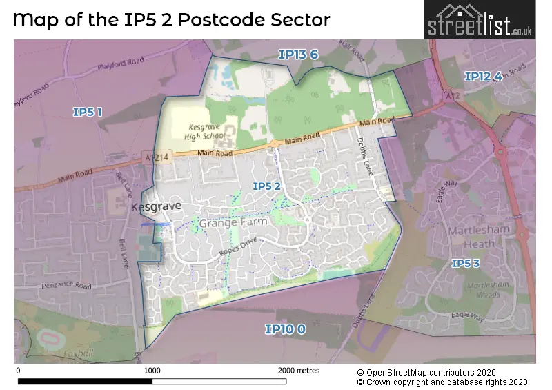
The IP5 2 postal code covers the settlement of Kesgrave.
The IP5 2 Postcode shares a border with IP5 1 (Kesgrave, Rushmere St. Andrew), IP13 6 (Grundisburgh, Ufford, Hasketon), IP5 3 (Martlesham Heath) and IP10 0 (Nacton, Kirton, Bucklesham).
The sector is within the post town of IPSWICH.
IP5 2 is a postcode sector within the IP5 postcode district which is within the IP Ipswich postcode area.
The Royal Mail delivery office for the IP5 2 postal sector is the Kesgrave Scale Payment Delivery Office and Ipswich East Delivery Office and Ipswich Delivery Office.
The area of the IP5 2 postcode sector is 1.15 square miles which is 2.98 square kilometres or 737.06 square acres.

Map of the IP5 2 Postcode Sector
Explore the IP5 2 postcode sector by using our free interactive map.
| I | P | 5 | - | 2 | X | X |
| I | P | 5 | Space | 2 | Letter | Letter |
Official List of Streets
Kesgrave (161 Streets)
Unofficial Streets or Alternative Spellings
Kesgrave
TWELVE ACRE APPROACH ALL SAINTS ROUNDABOUT ASHDALE WALK BADEN POWELL WAY CATCHPOLE CLOSE FENTONS WAY GRANGE BUSINESS CENTRE KESGRAVE BUSWAY LONG STROPS BRIDLEWAY PILBROUGHS WALK SAINT ISIDORES SAINT MARTINS COURT SIR WILLIAM COURT ST MARTINS COURT ST MICHAELS ROUNDABOUT WILKS COURTMartlesham Heath
DEBEN AVENUEWeather Forecast for IP5 2
Press Button to Show Forecast for Grundisburgh
| Time Period | Icon | Description | Temperature | Rain Probability | Wind |
|---|---|---|---|---|---|
| 21:00 to 00:00 | Partly cloudy (night) | 5.0°C (feels like 1.0°C) | 5.00% | NNW 13 mph |
Press Button to Show Forecast for Grundisburgh
| Time Period | Icon | Description | Temperature | Rain Probability | Wind |
|---|---|---|---|---|---|
| 00:00 to 03:00 | Partly cloudy (night) | 4.0°C (feels like 1.0°C) | 2.00% | NNW 11 mph | |
| 03:00 to 06:00 | Cloudy | 4.0°C (feels like 1.0°C) | 5.00% | NNW 11 mph | |
| 06:00 to 09:00 | Cloudy | 5.0°C (feels like 2.0°C) | 4.00% | NNW 9 mph | |
| 09:00 to 12:00 | Cloudy | 8.0°C (feels like 4.0°C) | 5.00% | N 13 mph | |
| 12:00 to 15:00 | Cloudy | 9.0°C (feels like 6.0°C) | 4.00% | N 16 mph | |
| 15:00 to 18:00 | Cloudy | 9.0°C (feels like 6.0°C) | 4.00% | N 16 mph | |
| 18:00 to 21:00 | Partly cloudy (day) | 7.0°C (feels like 4.0°C) | 2.00% | N 11 mph | |
| 21:00 to 00:00 | Cloudy | 5.0°C (feels like 2.0°C) | 6.00% | NNW 7 mph |
Press Button to Show Forecast for Grundisburgh
| Time Period | Icon | Description | Temperature | Rain Probability | Wind |
|---|---|---|---|---|---|
| 00:00 to 03:00 | Cloudy | 5.0°C (feels like 2.0°C) | 4.00% | NNW 7 mph | |
| 03:00 to 06:00 | Overcast | 4.0°C (feels like 1.0°C) | 8.00% | NNW 9 mph | |
| 06:00 to 09:00 | Overcast | 5.0°C (feels like 2.0°C) | 8.00% | NNW 9 mph | |
| 09:00 to 12:00 | Overcast | 8.0°C (feels like 5.0°C) | 10.00% | N 13 mph | |
| 12:00 to 15:00 | Cloudy | 9.0°C (feels like 7.0°C) | 7.00% | NNE 13 mph | |
| 15:00 to 18:00 | Cloudy | 10.0°C (feels like 7.0°C) | 6.00% | NNE 13 mph | |
| 18:00 to 21:00 | Partly cloudy (day) | 8.0°C (feels like 5.0°C) | 2.00% | NNE 11 mph | |
| 21:00 to 00:00 | Partly cloudy (night) | 6.0°C (feels like 3.0°C) | 2.00% | N 9 mph |
Press Button to Show Forecast for Grundisburgh
| Time Period | Icon | Description | Temperature | Rain Probability | Wind |
|---|---|---|---|---|---|
| 00:00 to 03:00 | Partly cloudy (night) | 5.0°C (feels like 2.0°C) | 1.00% | N 9 mph | |
| 03:00 to 06:00 | Clear night | 4.0°C (feels like 1.0°C) | 1.00% | N 7 mph | |
| 06:00 to 09:00 | Partly cloudy (day) | 5.0°C (feels like 2.0°C) | 2.00% | N 9 mph | |
| 09:00 to 12:00 | Cloudy | 9.0°C (feels like 6.0°C) | 6.00% | NNE 9 mph | |
| 12:00 to 15:00 | Cloudy | 9.0°C (feels like 8.0°C) | 9.00% | NNE 9 mph | |
| 15:00 to 18:00 | Overcast | 9.0°C (feels like 7.0°C) | 13.00% | NNE 9 mph | |
| 18:00 to 21:00 | Cloudy | 7.0°C (feels like 6.0°C) | 15.00% | NE 7 mph | |
| 21:00 to 00:00 | Cloudy | 6.0°C (feels like 4.0°C) | 11.00% | NE 7 mph |
Press Button to Show Forecast for Grundisburgh
| Time Period | Icon | Description | Temperature | Rain Probability | Wind |
|---|---|---|---|---|---|
| 00:00 to 03:00 | Cloudy | 5.0°C (feels like 3.0°C) | 10.00% | WNW 7 mph | |
| 03:00 to 06:00 | Cloudy | 4.0°C (feels like 2.0°C) | 12.00% | NW 7 mph | |
| 06:00 to 09:00 | Cloudy | 5.0°C (feels like 3.0°C) | 11.00% | NNW 7 mph | |
| 09:00 to 12:00 | Cloudy | 8.0°C (feels like 6.0°C) | 10.00% | NNE 7 mph | |
| 12:00 to 15:00 | Overcast | 10.0°C (feels like 7.0°C) | 11.00% | NNE 9 mph | |
| 15:00 to 18:00 | Overcast | 10.0°C (feels like 7.0°C) | 13.00% | NNE 9 mph | |
| 18:00 to 21:00 | Cloudy | 9.0°C (feels like 6.0°C) | 8.00% | NNE 9 mph | |
| 21:00 to 00:00 | Overcast | 6.0°C (feels like 4.0°C) | 8.00% | NNE 9 mph |
Schools and Places of Education Within the IP5 2 Postcode Sector
Cedarwood Primary School
Community school
Wilkinson Drive, Ipswich, Suffolk, IP5 2ES
Head: Mrs Tina Shute
Ofsted Rating: Good
Inspection: 2023-01-19 (456 days ago)
Website: Visit Cedarwood Primary School Website
Phone: 01473612981
Number of Pupils: 420
Kesgrave High School
Academy converter
Main Road, Ipswich, Suffolk, IP5 2PB
Head: Miss Julia Upton
Ofsted Rating: Good
Inspection: 2022-12-07 (499 days ago)
Website: Visit Kesgrave High School Website
Phone: 01473624855
Number of Pupils: 1875
House Prices in the IP5 2 Postcode Sector
| Type of Property | 2018 Average | 2018 Sales | 2017 Average | 2017 Sales | 2016 Average | 2016 Sales | 2015 Average | 2015 Sales |
|---|---|---|---|---|---|---|---|---|
| Detached | £358,883 | 92 | £348,097 | 118 | £331,295 | 99 | £306,146 | 124 |
| Semi-Detached | £252,630 | 33 | £254,521 | 44 | £240,028 | 33 | £217,485 | 33 |
| Terraced | £226,953 | 53 | £225,342 | 49 | £207,464 | 72 | £193,998 | 73 |
| Flats | £166,842 | 19 | £163,386 | 22 | £145,300 | 32 | £141,928 | 28 |
Important Postcodes IP5 2 in the Postcode Sector
IP5 2ES is the postcode for Cedarwood Primary School, Wilkinson Drive, and CEDARWOOD PRIMARY SCHOOL, WILKINSON DRIVE, KESGRAVE
IP5 2PB is the postcode for SPORTS HALL/DRAMA, Kesgrave High School, Main Road, Kesgrave High School, Main Road, Kesgrave, SIXTH FORM, Kesgrave High School, Main Road, SCIENCE BLOCK, Kesgrave High School, Main Road, TECHNICAL BLOCK, Kesgrave High School, Main Road, Kesgrave High School, Main Road, and COMMUNICATIONS BLOCK, Kesgrave High School, Main Road
| The IP5 2 Sector is within these Local Authorities |
|
|---|---|
| The IP5 2 Sector is within these Counties |
|
| The IP5 2 Sector is within these Water Company Areas |
|