The IP7 postcode district is a postal district located in the IP Ipswich postcode area with a population of 17,026 residents according to the 2021 England and Wales Census.
The area of the IP7 postcode district is 57.04 square miles which is 147.73 square kilometres or 36,505.89 acres.
Currently, the IP7 district has about 674 postcode units spread across 3 geographic postcode sectors.
Given that each sector allows for 400 unique postcode combinations, the district has a capacity of 1,200 postcodes. With 674 postcodes already in use, this leaves 526 units available.
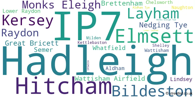
The largest settlement in the IP7 postal code is Hadleigh followed by Elmsett, and Bildeston.
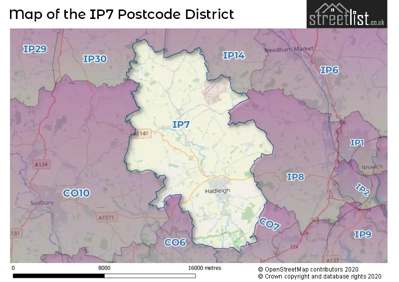
The IP7 Postcode shares a border with IP14 (STOWMARKET, Stowupland, Debenham), IP30 (Elmswell, Woolpit, Cockfield), IP8 (Bramford, IPSWICH, Sproughton), CO10 (SUDBURY, Great Cornard, Long Melford), CO6 (Coggeshall, Earls Colne, West Bergholt) and CO7 (Brightlingsea, Wivenhoe, Great Bentley).
The primary settlement in the IP7 postcode district is Hadleigh, located in Ipswich, Suffolk. Other significant settlements in the district include Aldham, Elmsett, Kersey, Semer, and Whatfield. The county where these settlements are situated is Suffolk, in England. The most significant post town in the IP7 postcode district is Ipswich.
For the district IP7, we have data on 4 postcode sectors. Here's a breakdown: The sector IP7 5, covers Hadleigh and Layham in Suffolk. The sector IP7 6, covers Hadleigh and Elmsett and Kersey in Suffolk. The sector IP7 7, covers Hitcham and Bildeston and Monks Eleigh in Suffolk. The sector IP7 9 is non-geographic. It's often designated for PO Boxes, large organisations, or special services.

Map of the IP7 Postcode District
Explore the IP7 postcode district by using our free interactive map.
When it comes to local government, postal geography often disregards political borders. However, for a breakdown in the IP7 District: the district mostly encompasses the Babergh District (651 postcodes), and finally, the Mid Suffolk District area (38 postcodes).
Recent House Sales in IP7
| Date | Price | Address |
|---|---|---|
| 20/09/2023 | £400,000 | Squirrells Mill Road, Bildeston, Ipswich, IP7 7DY |
| 15/09/2023 | £385,000 | Hadleigh Road, Elmsett, Ipswich, IP7 6ND |
| 01/09/2023 | £200,000 | Aylward Close, Hadleigh, Ipswich, IP7 5SJ |
| 21/08/2023 | £467,500 | Barnes Close, Hadleigh, Ipswich, IP7 5NN |
| 15/08/2023 | £450,000 | Dunningham Drive, Raydon, Ipswich, IP7 5FN |
| 15/08/2023 | £80,000 | Hadleigh Road, Elmsett, Ipswich, IP7 6ND |
| 14/08/2023 | £880,000 | High Street, Bildeston, Ipswich, IP7 7EF |
| 10/08/2023 | £370,000 | Windings Road, Elmsett, Ipswich, IP7 6QE |
| 01/08/2023 | £325,000 | Middle Meadow, Hadleigh, Ipswich, IP7 6FW |
| 31/07/2023 | £995,000 | Manor Road, Elmsett, Ipswich, IP7 6PN |
Weather Forecast for IP7
Press Button to Show Forecast for Hadleigh (Suffolk)
| Time Period | Icon | Description | Temperature | Rain Probability | Wind |
|---|---|---|---|---|---|
| 15:00 to 18:00 | Cloudy | 8.0°C (feels like 5.0°C) | 15.00% | NNW 11 mph | |
| 18:00 to 21:00 | Cloudy | 7.0°C (feels like 5.0°C) | 9.00% | NNE 7 mph | |
| 21:00 to 00:00 | Cloudy | 4.0°C (feels like 3.0°C) | 5.00% | N 2 mph |
Press Button to Show Forecast for Hadleigh (Suffolk)
| Time Period | Icon | Description | Temperature | Rain Probability | Wind |
|---|---|---|---|---|---|
| 00:00 to 03:00 | Clear night | 2.0°C (feels like 0.0°C) | 0.00% | N 4 mph | |
| 03:00 to 06:00 | Clear night | 0.0°C (feels like -2.0°C) | 0.00% | NNW 4 mph | |
| 06:00 to 09:00 | Sunny day | 3.0°C (feels like 0.0°C) | 1.00% | NNW 4 mph | |
| 09:00 to 12:00 | Partly cloudy (day) | 8.0°C (feels like 7.0°C) | 1.00% | NE 4 mph | |
| 12:00 to 15:00 | Cloudy | 11.0°C (feels like 10.0°C) | 7.00% | ENE 4 mph | |
| 15:00 to 18:00 | Overcast | 10.0°C (feels like 8.0°C) | 11.00% | ESE 7 mph | |
| 18:00 to 21:00 | Cloudy | 9.0°C (feels like 7.0°C) | 9.00% | ESE 7 mph | |
| 21:00 to 00:00 | Cloudy | 5.0°C (feels like 4.0°C) | 9.00% | ENE 4 mph |
Press Button to Show Forecast for Hadleigh (Suffolk)
| Time Period | Icon | Description | Temperature | Rain Probability | Wind |
|---|---|---|---|---|---|
| 00:00 to 03:00 | Cloudy | 4.0°C (feels like 2.0°C) | 11.00% | NE 4 mph | |
| 03:00 to 06:00 | Cloudy | 4.0°C (feels like 1.0°C) | 13.00% | NE 7 mph | |
| 06:00 to 09:00 | Cloudy | 5.0°C (feels like 3.0°C) | 19.00% | NE 7 mph | |
| 09:00 to 12:00 | Cloudy | 10.0°C (feels like 8.0°C) | 14.00% | E 9 mph | |
| 12:00 to 15:00 | Overcast | 12.0°C (feels like 10.0°C) | 17.00% | E 9 mph | |
| 15:00 to 18:00 | Cloudy | 12.0°C (feels like 10.0°C) | 13.00% | E 11 mph | |
| 18:00 to 21:00 | Cloudy | 10.0°C (feels like 8.0°C) | 18.00% | ENE 11 mph | |
| 21:00 to 00:00 | Light rain | 9.0°C (feels like 6.0°C) | 51.00% | ENE 11 mph |
Press Button to Show Forecast for Hadleigh (Suffolk)
| Time Period | Icon | Description | Temperature | Rain Probability | Wind |
|---|---|---|---|---|---|
| 00:00 to 03:00 | Light rain shower (night) | 10.0°C (feels like 7.0°C) | 42.00% | ENE 11 mph | |
| 03:00 to 06:00 | Heavy rain | 10.0°C (feels like 8.0°C) | 77.00% | ESE 9 mph | |
| 06:00 to 09:00 | Light rain shower (day) | 10.0°C (feels like 8.0°C) | 40.00% | SE 9 mph | |
| 09:00 to 12:00 | Light rain shower (day) | 12.0°C (feels like 9.0°C) | 40.00% | SSE 13 mph | |
| 12:00 to 15:00 | Light rain shower (day) | 12.0°C (feels like 9.0°C) | 40.00% | S 16 mph | |
| 15:00 to 18:00 | Heavy rain shower (day) | 13.0°C (feels like 11.0°C) | 58.00% | SSW 13 mph | |
| 18:00 to 21:00 | Partly cloudy (day) | 12.0°C (feels like 11.0°C) | 12.00% | SW 9 mph | |
| 21:00 to 00:00 | Partly cloudy (night) | 9.0°C (feels like 7.0°C) | 6.00% | WSW 9 mph |
Where is the IP7 Postcode District?
The postcode district IP7 is located in Ipswich. This district is near several towns, including Stowmarket to the north (8.20 miles), Sudbury to the west (8.60 miles), Bures to the southwest (9.92 miles), Manningtree to the southeast (12.35 miles), Colchester to the south (13.31 miles), Bury St. Edmunds to the northwest (14.49 miles), and Woodbridge to the east (16.22 miles). Additionally, IP7 is approximately 60.20 miles away from the centre of London.
The district is within the post town of IPSWICH.
The sector has postcodes within the nation of England.
The IP7 Postcode District is in the Suffolk region of East Anglia within the East of England.
| Postcode Sector | Delivery Office |
|---|---|
| IP7 5 | Hadleigh Delivery Office |
| IP7 6 | Hadleigh Delivery Office |
| IP7 6 | Ipswich Delivery Office |
| IP7 7 | Hadleigh Delivery Office |
| IP7 7 | Ipswich Delivery Office |
| I | P | 7 | - | X | X | X |
| I | P | 7 | Space | Numeric | Letter | Letter |
Tourist Attractions within the Postcode Area
We found 1 visitor attractions within the IP7 postcode area
| Orwell River Cruises Limited |
|---|
| Historic Properties |
| Other Historic / Scenic Transport Operator |
| View Orwell River Cruises Limited on Google Maps |
Current Monthly Rental Prices
| # Bedrooms | Min Price | Max Price | Avg Price |
|---|---|---|---|
| 2 | £725 | £1,050 | £906 |
| 3 | £1,500 | £1,500 | £1,500 |
Current House Prices
| # Bedrooms | Min Price | Max Price | Avg Price |
|---|---|---|---|
| £25,000 | £1,150,000 | £377,217 | |
| 1 | £165,000 | £275,000 | £222,500 |
| 2 | £75,000 | £750,000 | £256,383 |
| 3 | £250,000 | £875,000 | £408,587 |
| 4 | £325,000 | £1,150,000 | £568,023 |
| 5 | £525,000 | £1,900,000 | £1,012,099 |
| 6 | £650,000 | £1,650,000 | £1,207,500 |
| 7 | £1,850,000 | £1,850,000 | £1,850,000 |
Estate Agents who Operate in the IP7 District
| Logo | Name | Brand Name | Address | Contact Number | Total Properties |
|---|---|---|---|---|---|
 | Hadleigh | Frost and Partners | 62 High Street, Hadleigh, IP7 5EF | 01473 943944 | 34 |
 | Hadleigh | Chapman Stickels | The Corn Exchange, Market Place, Hadleigh, IP7 5DN | 01473 943929 | 21 |
 | Hadleigh | Hizzy | Hadleigh Business Centre Crockatt Road Hadleigh IP7 6RH | 01473 943623 | 14 |
 | Long Melford | Carter Jonas | St Marys Court, Little St. Marys, Long Melford, CO10 9LQ | 01787 322223 | 9 |
 | East Bergholt | Grier & Partners | The Street, East Bergholt, CO7 6TF | 01206 586076 | 7 |
- Aldham
- Bildeston
- Bird Street
- Brettenham
- Chelsworth
- Cook's Green
- Coopers Corner
- Cross Green
- Duke Street
- Elmsett
- Great Bricett
- Hadleigh
- Hitcham
- Kersey
- Lower Layham
- Lower Raydon
- Milden
- Monks Eleigh
- Naughton
- Nedging
- Nedging Tye
- Oaks Tye
- Polstead
- Polstead Heath
- Raydon
- Ringshall Stocks
- Semer
- Shelley
- Swingleton Green
- Thorpe Morieux
- Upper Layham
- Wattisham
- Wattisham Stone
- Whatfield
- Whelp Street
- William's Green
| Type of Property | 2018 Average | 2018 Sales | 2017 Average | 2017 Sales | 2016 Average | 2016 Sales | 2015 Average | 2015 Sales |
|---|---|---|---|---|---|---|---|---|
| Detached | £420,260 | 94 | £457,892 | 127 | £411,837 | 121 | £342,877 | 101 |
| Semi-Detached | £318,675 | 59 | £256,483 | 64 | £279,443 | 55 | £258,433 | 60 |
| Terraced | £223,320 | 54 | £261,416 | 47 | £214,181 | 41 | £210,341 | 56 |
| Flats | £155,400 | 5 | £65,125 | 2 | £64,000 | 2 | £67,081 | 3 |