The IV48 postcode district is a postal district located in the IV Inverness postcode area with a population of 81 residents according to the 2011 Scotland Census.
The area of the IV48 postcode district is 11.22 square miles which is 29.07 square kilometres or 7,182.56 acres.
Currently, the IV48 district has about 1 postcode units spread across 0 geographic postcode sectors.
Given that each sector allows for 400 unique postcode combinations, the district has a capacity of 0 postcodes. With 1 postcodes already in use, this leaves -1 units available.
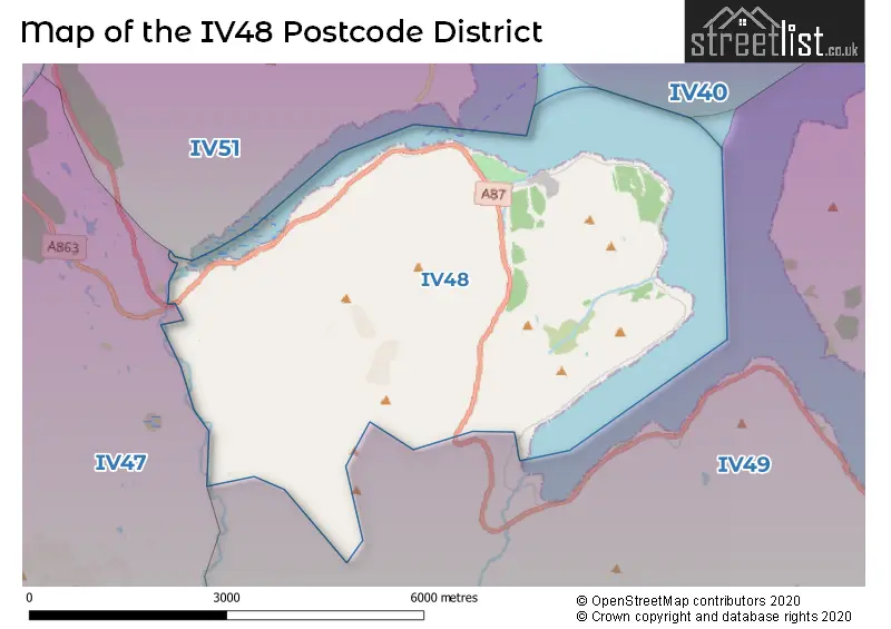
The IV48 postal code covers the settlement of Sconser.
The postcode area has a boundary with The Minch.
The IV48 Postcode shares a border with IV49 (Broadford, Elgol, Torrin).
The primary settlement in the IV48 postcode district is Sconser, located in Ross and Cromarty, within the county of Ross and Cromarty in Scotland. Additionally, there are no other significant settlements mentioned in the data. The most significant post town in this postcode district is Isle of Skye.
For the district IV48, we have data on 1 postcode sectors. Here's a breakdown: The sector IV48 8 is non-geographic. It's often designated for PO Boxes, large organisations, or special services.
IV48 Postcode Sectors


Map of the IV48 Postcode District
Explore the IV48 postcode district by using our free interactive map.
There are no postcodes assigned to any local authorities in the IV48 District.
Weather Forecast for IV48
Press Button to Show Forecast for Inverarish
| Time Period | Icon | Description | Temperature | Rain Probability | Wind |
|---|---|---|---|---|---|
| 21:00 to 00:00 | Clear night | 5.0°C (feels like 3.0°C) | 0.00% | NNE 9 mph |
Press Button to Show Forecast for Inverarish
| Time Period | Icon | Description | Temperature | Rain Probability | Wind |
|---|---|---|---|---|---|
| 00:00 to 03:00 | Clear night | 4.0°C (feels like 2.0°C) | 1.00% | NNE 7 mph | |
| 03:00 to 06:00 | Cloudy | 3.0°C (feels like 1.0°C) | 4.00% | NNE 4 mph | |
| 06:00 to 09:00 | Partly cloudy (day) | 4.0°C (feels like 2.0°C) | 0.00% | N 7 mph | |
| 09:00 to 12:00 | Partly cloudy (day) | 7.0°C (feels like 5.0°C) | 7.00% | N 7 mph | |
| 12:00 to 15:00 | Partly cloudy (day) | 8.0°C (feels like 6.0°C) | 33.00% | N 11 mph | |
| 15:00 to 18:00 | Light rain shower (day) | 8.0°C (feels like 6.0°C) | 32.00% | N 9 mph | |
| 18:00 to 21:00 | Partly cloudy (day) | 7.0°C (feels like 5.0°C) | 8.00% | N 9 mph | |
| 21:00 to 00:00 | Partly cloudy (night) | 5.0°C (feels like 3.0°C) | 1.00% | N 7 mph |
Press Button to Show Forecast for Inverarish
| Time Period | Icon | Description | Temperature | Rain Probability | Wind |
|---|---|---|---|---|---|
| 00:00 to 03:00 | Cloudy | 4.0°C (feels like 2.0°C) | 4.00% | N 4 mph | |
| 03:00 to 06:00 | Cloudy | 3.0°C (feels like 1.0°C) | 5.00% | N 4 mph | |
| 06:00 to 09:00 | Cloudy | 4.0°C (feels like 3.0°C) | 6.00% | NNE 2 mph | |
| 09:00 to 12:00 | Cloudy | 7.0°C (feels like 7.0°C) | 8.00% | NE 2 mph | |
| 12:00 to 15:00 | Cloudy | 9.0°C (feels like 8.0°C) | 16.00% | SE 4 mph | |
| 15:00 to 18:00 | Light rain shower (day) | 9.0°C (feels like 7.0°C) | 33.00% | NW 7 mph | |
| 18:00 to 21:00 | Light rain shower (day) | 8.0°C (feels like 7.0°C) | 29.00% | NE 4 mph | |
| 21:00 to 00:00 | Partly cloudy (night) | 6.0°C (feels like 5.0°C) | 3.00% | N 2 mph |
Press Button to Show Forecast for Inverarish
| Time Period | Icon | Description | Temperature | Rain Probability | Wind |
|---|---|---|---|---|---|
| 00:00 to 03:00 | Clear night | 4.0°C (feels like 3.0°C) | 2.00% | N 2 mph | |
| 03:00 to 06:00 | Clear night | 4.0°C (feels like 2.0°C) | 2.00% | N 4 mph | |
| 06:00 to 09:00 | Sunny day | 5.0°C (feels like 3.0°C) | 4.00% | NNE 2 mph | |
| 09:00 to 12:00 | Partly cloudy (day) | 8.0°C (feels like 7.0°C) | 9.00% | N 4 mph | |
| 12:00 to 15:00 | Cloudy | 9.0°C (feels like 8.0°C) | 13.00% | N 4 mph | |
| 15:00 to 18:00 | Cloudy | 9.0°C (feels like 8.0°C) | 17.00% | WNW 7 mph | |
| 18:00 to 21:00 | Partly cloudy (day) | 9.0°C (feels like 7.0°C) | 12.00% | NW 7 mph | |
| 21:00 to 00:00 | Cloudy | 7.0°C (feels like 5.0°C) | 10.00% | W 7 mph |
Where is the IV48 Postcode District?
The data postcode district IV48 is located in the town of Isle of Skye. Isle of Skye is situated in close proximity to various nearby towns. To the east of Isle of Skye is Edinburgh, which is approximately 14.8 miles away. To the north of Isle of Skye is Portree, which is roughly 16.1 miles away. To the south of Isle of Skye is Isle of Rum, located at a distance of about 20.3 miles. The south-west of Isle of Skye is Isle of Canna, roughly 22 miles away. Lastly, the south-east of Isle of Skye is Mallaig, which is approximately 22.6 miles away. In addition, the distance between Isle of Skye and the center of London is approximately 466.7 miles.
The district is within the post town of ISLE OF SKYE.
The sector has postcodes within the nation of Scotland.
The IV48 Postcode District is covers the following regions.
- Caithness & Sutherland and Ross & Cromarty - Highlands and Islands - Scotland
- Inverness & Nairn and Moray, Badenoch & Strathspey - Highlands and Islands - Scotland
- Lochaber, Skye & Lochalsh, Arran & Cumbrae and Argyll & Bute - Highlands and Islands - Scotland
Postcode Sectors within the IV48 District
Postcode Districts that Share a Border with IV48
| Postcode Sector | Delivery Office |
|---|---|
| IV48 8 | Sconser Scale Payment Delivery Office |
| I | V | 4 | 8 | - | X | X | X |
| I | V | 4 | 8 | Space | Numeric | Letter | Letter |
Current Monthly Rental Prices
| # Bedrooms | Min Price | Max Price | Avg Price |
|---|
Current House Prices
| # Bedrooms | Min Price | Max Price | Avg Price |
|---|
Estate Agents who Operate in the IV48 District
| Logo | Name | Brand Name | Address | Contact Number | Total Properties |
|---|