The KA15 postcode district is a postal district located in the KA Kilmarnock postcode area with a population of 7,166 residents according to the 2011 Scotland Census.
The area of the KA15 postcode district is 17.64 square miles which is 45.70 square kilometres or 11,291.47 acres.
Currently, the KA15 district has about 237 postcode units spread across 2 geographic postcode sectors.
Given that each sector allows for 400 unique postcode combinations, the district has a capacity of 800 postcodes. With 237 postcodes already in use, this leaves 563 units available.
The largest settlement in the KA15 postal code is BEITH followed by Barrmill, and Burnhouse.
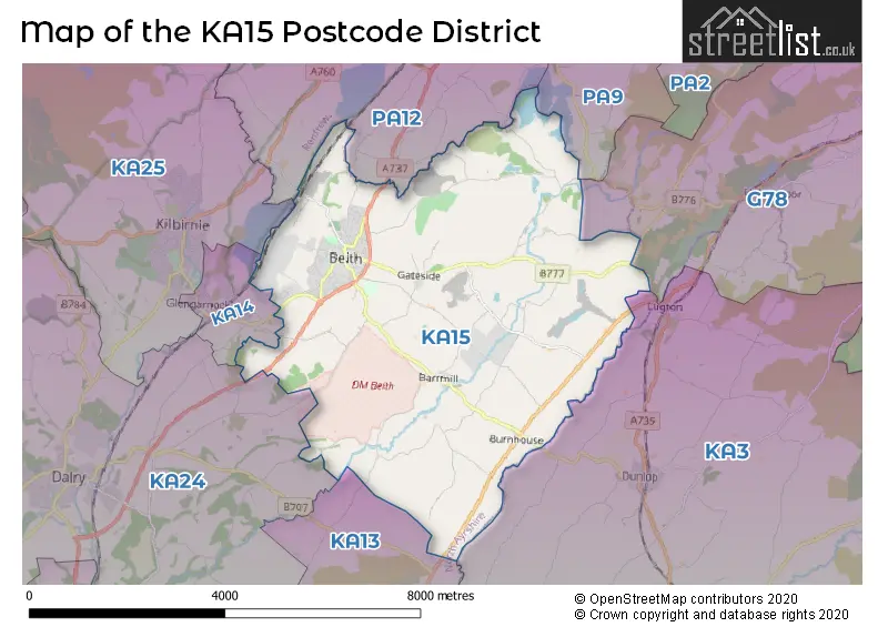
The KA15 Postcode shares a border with G78 (Barrhead, Neilston, Uplawmoor), KA3 (KILMARNOCK, Stewarton, Kilmaurs), KA24 (DALRY), PA9 (Howwood), PA12 (LOCHWINNOCH), KA14 (Glengarnock) and KA13 (KILWINNING).
The primary settlement in the KA15 postcode district is Beith, located in the county of Ayrshire and Arran. The most significant postal town in this district is Beith, which is also in Ayrshire and Arran.
For the district KA15, we have data on 2 postcode sectors. Here's a breakdown: The sector KA15 1, covers Beith in Ayrshire and Arran. The sector KA15 2, covers Beith in Ayrshire and Arran.

Map of the KA15 Postcode District
Explore the KA15 postcode district by using our free interactive map.
When it comes to local government, postal geography often disregards political borders. However, for a breakdown in the KA15 District: the district mostly encompasses the North Ayrshire area with a total of 237 postcodes.
Weather Forecast for KA15
Press Button to Show Forecast for Beith
| Time Period | Icon | Description | Temperature | Rain Probability | Wind |
|---|---|---|---|---|---|
| 09:00 to 12:00 | Sunny day | 7.0°C (feels like 5.0°C) | 0.00% | W 4 mph | |
| 12:00 to 15:00 | Sunny day | 10.0°C (feels like 8.0°C) | 0.00% | NW 4 mph | |
| 15:00 to 18:00 | Partly cloudy (day) | 11.0°C (feels like 9.0°C) | 1.00% | WNW 7 mph | |
| 18:00 to 21:00 | Sunny day | 10.0°C (feels like 7.0°C) | 0.00% | WNW 11 mph | |
| 21:00 to 00:00 | Partly cloudy (night) | 7.0°C (feels like 4.0°C) | 1.00% | WNW 9 mph |
Press Button to Show Forecast for Beith
| Time Period | Icon | Description | Temperature | Rain Probability | Wind |
|---|---|---|---|---|---|
| 00:00 to 03:00 | Cloudy | 5.0°C (feels like 3.0°C) | 4.00% | WNW 7 mph | |
| 03:00 to 06:00 | Cloudy | 4.0°C (feels like 2.0°C) | 5.00% | NW 4 mph | |
| 06:00 to 09:00 | Sunny day | 5.0°C (feels like 3.0°C) | 2.00% | N 4 mph | |
| 09:00 to 12:00 | Cloudy | 7.0°C (feels like 5.0°C) | 5.00% | N 7 mph | |
| 12:00 to 15:00 | Overcast | 9.0°C (feels like 7.0°C) | 11.00% | N 7 mph | |
| 15:00 to 18:00 | Light rain | 9.0°C (feels like 8.0°C) | 37.00% | NNE 4 mph | |
| 18:00 to 21:00 | Light rain | 8.0°C (feels like 7.0°C) | 38.00% | NE 4 mph | |
| 21:00 to 00:00 | Cloudy | 5.0°C (feels like 3.0°C) | 6.00% | ENE 7 mph |
Press Button to Show Forecast for Beith
| Time Period | Icon | Description | Temperature | Rain Probability | Wind |
|---|---|---|---|---|---|
| 00:00 to 03:00 | Cloudy | 4.0°C (feels like 1.0°C) | 8.00% | ENE 4 mph | |
| 03:00 to 06:00 | Cloudy | 3.0°C (feels like 1.0°C) | 9.00% | NE 4 mph | |
| 06:00 to 09:00 | Cloudy | 4.0°C (feels like 1.0°C) | 10.00% | NE 4 mph | |
| 09:00 to 12:00 | Cloudy | 6.0°C (feels like 4.0°C) | 11.00% | ENE 7 mph | |
| 12:00 to 15:00 | Light rain | 8.0°C (feels like 6.0°C) | 40.00% | ENE 7 mph | |
| 15:00 to 18:00 | Light rain | 8.0°C (feels like 7.0°C) | 42.00% | NE 4 mph | |
| 18:00 to 21:00 | Cloudy | 8.0°C (feels like 6.0°C) | 14.00% | NE 4 mph | |
| 21:00 to 00:00 | Partly cloudy (night) | 5.0°C (feels like 3.0°C) | 10.00% | ENE 4 mph |
Press Button to Show Forecast for Beith
| Time Period | Icon | Description | Temperature | Rain Probability | Wind |
|---|---|---|---|---|---|
| 00:00 to 03:00 | Partly cloudy (night) | 3.0°C (feels like 1.0°C) | 9.00% | NE 4 mph | |
| 03:00 to 06:00 | Cloudy | 3.0°C (feels like 0.0°C) | 11.00% | ENE 4 mph | |
| 06:00 to 09:00 | Cloudy | 4.0°C (feels like 2.0°C) | 12.00% | ENE 4 mph | |
| 09:00 to 12:00 | Light rain shower (day) | 7.0°C (feels like 5.0°C) | 31.00% | E 7 mph | |
| 12:00 to 15:00 | Light rain | 9.0°C (feels like 7.0°C) | 44.00% | E 7 mph | |
| 15:00 to 18:00 | Cloudy | 9.0°C (feels like 8.0°C) | 16.00% | E 7 mph | |
| 18:00 to 21:00 | Light rain shower (day) | 9.0°C (feels like 7.0°C) | 36.00% | ENE 7 mph | |
| 21:00 to 00:00 | Cloudy | 6.0°C (feels like 4.0°C) | 8.00% | ENE 7 mph |
Where is the KA15 Postcode District?
The postcode district for KA15 is located in the town of Beith. It is in close proximity to the nearby towns of Lochwinnoch, Kilbirnie, Kilwinning, Johnstone, and Glasgow. Additionally, it is approximately 345.46 miles away from the city centre of London.
The district is within the post town of BEITH.
The sector has postcodes within the nation of Scotland.
The KA15 Postcode District is covers the following regions.
- Lochaber, Skye & Lochalsh, Arran & Cumbrae and Argyll & Bute - Highlands and Islands - Scotland
- East Ayrshire and North Ayrshire mainland - Southern Scotland - Scotland
| Postcode Sector | Delivery Office |
|---|---|
| KA15 1 | Beith Delivery Office |
| KA15 2 | Beith Delivery Office |
| K | A | 1 | 5 | - | X | X | X |
| K | A | 1 | 5 | Space | Numeric | Letter | Letter |
Current Monthly Rental Prices
| # Bedrooms | Min Price | Max Price | Avg Price |
|---|---|---|---|
| 2 | £465 | £465 | £465 |
Current House Prices
| # Bedrooms | Min Price | Max Price | Avg Price |
|---|---|---|---|
| £75,000 | £295,000 | £185,000 | |
| 1 | £68,000 | £68,000 | £68,000 |
| 2 | £69,995 | £225,000 | £119,831 |
| 3 | £64,995 | £385,000 | £163,999 |
| 4 | £360,000 | £360,000 | £360,000 |
| 5 | £276,995 | £276,995 | £276,995 |
| 7 | £1,200,000 | £1,200,000 | £1,200,000 |
Estate Agents who Operate in the KA15 District
| Logo | Name | Brand Name | Address | Contact Number | Total Properties |
|---|---|---|---|---|---|
 | Glasgow | The Property Boom Ltd | 31 Braehead, Beith, North Ayrshire KA15 1EG | 03339 009089 | 6 |
 | Ayr | Galbraith | 7 Killoch Place, Ayr, KA7 2EA | 01292 431549 | 2 |
 | Scotland | Lowther Homes | �Wheatley House 25 Cochrane Street Glasgow G1 1HL | 0141 212 4419 | 1 |
 | Lytham | Sell My Group | The Old Bakery Green Street, Lytham, Lytham St. Annes, FY8 5LG | 020 3910 6164 | 1 |
 | Glasgow | Robb Residential | The Beacon 176 St Vincent Street Glasgow G2 5SG | 0141 673 4582 | 1 |