The KA6 postcode district is a postal district located in the KA Kilmarnock postcode area with a population of 19,471 residents according to the 2011 Scotland Census.
The area of the KA6 postcode district is 127.24 square miles which is 329.55 square kilometres or 81,433.41 acres.
Currently, the KA6 district has about 525 postcode units spread across 3 geographic postcode sectors.
Given that each sector allows for 400 unique postcode combinations, the district has a capacity of 1,200 postcodes. With 525 postcodes already in use, this leaves 675 units available.
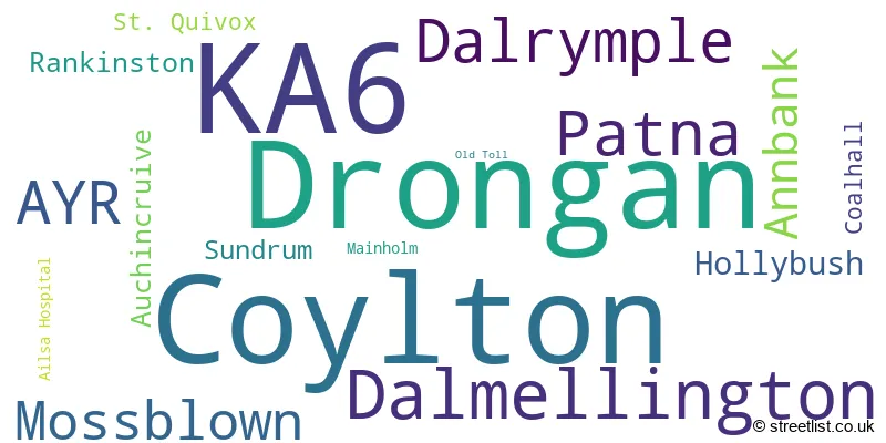
The largest settlement in the KA6 postal code is Dalmellington followed by Drongan, and Coylton.
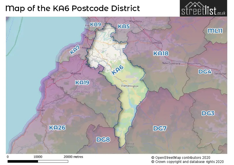
The KA6 Postcode shares a border with DG7 (CASTLE DOUGLAS, Gatehouse Of Fleet, Dalry), KA19 (MAYBOLE, Crosshill, Straiton), KA7 (AYR, Dunure, Doonfoot), KA9 (PRESTWICK, Monkton), KA18 (CUMNOCK, Auchinleck, New Cumnock), KA5 (MAUCHLINE, Catrine, Tarbolton) and DG8 (NEWTON STEWART, Wigtown, Glenluce).
The primary settlement in the KA6 postcode district is Mossblown, located in Ayrshire and Arran. The post town for this district is Ayr in the county of Ayrshire and Arran.There are also significant settlements in this district such as Coylton, Sundrum, and Auchincruive.
For the district KA6, we have data on 3 postcode sectors. Here's a breakdown: The sector KA6 5, covers Mossblown and Annbank and Ayr in Ayrshire and Arran. The sector KA6 6, covers Coylton and Dalrymple and Ayr in Ayrshire and Arran. The sector KA6 7, covers Drongan and Dalmellington and Patna in Ayrshire and Arran.

Map of the KA6 Postcode District
Explore the KA6 postcode district by using our free interactive map.
When it comes to local government, postal geography often disregards political borders. However, for a breakdown in the KA6 District: the district mostly encompasses the East Ayrshire (278 postcodes), and finally, the South Ayrshire area (247 postcodes).
Weather Forecast for KA6
Press Button to Show Forecast for Dalmellington
| Time Period | Icon | Description | Temperature | Rain Probability | Wind |
|---|---|---|---|---|---|
| 18:00 to 21:00 | Cloudy | 9.0°C (feels like 7.0°C) | 4.00% | NNW 7 mph | |
| 21:00 to 00:00 | Partly cloudy (night) | 6.0°C (feels like 4.0°C) | 0.00% | NNW 7 mph |
Press Button to Show Forecast for Dalmellington
| Time Period | Icon | Description | Temperature | Rain Probability | Wind |
|---|---|---|---|---|---|
| 00:00 to 03:00 | Partly cloudy (night) | 4.0°C (feels like 3.0°C) | 0.00% | NE 2 mph | |
| 03:00 to 06:00 | Cloudy | 4.0°C (feels like 2.0°C) | 4.00% | ENE 2 mph | |
| 06:00 to 09:00 | Sunny day | 4.0°C (feels like 3.0°C) | 0.00% | WNW 2 mph | |
| 09:00 to 12:00 | Cloudy | 9.0°C (feels like 7.0°C) | 3.00% | NW 7 mph | |
| 12:00 to 15:00 | Partly cloudy (day) | 10.0°C (feels like 9.0°C) | 1.00% | NW 7 mph | |
| 15:00 to 18:00 | Cloudy | 11.0°C (feels like 9.0°C) | 5.00% | NW 7 mph | |
| 18:00 to 21:00 | Partly cloudy (day) | 10.0°C (feels like 9.0°C) | 1.00% | WNW 7 mph | |
| 21:00 to 00:00 | Cloudy | 7.0°C (feels like 7.0°C) | 4.00% | WNW 2 mph |
Press Button to Show Forecast for Dalmellington
| Time Period | Icon | Description | Temperature | Rain Probability | Wind |
|---|---|---|---|---|---|
| 00:00 to 03:00 | Partly cloudy (night) | 6.0°C (feels like 5.0°C) | 7.00% | SW 2 mph | |
| 03:00 to 06:00 | Cloudy | 5.0°C (feels like 5.0°C) | 4.00% | SW 2 mph | |
| 06:00 to 09:00 | Partly cloudy (day) | 6.0°C (feels like 5.0°C) | 1.00% | S 2 mph | |
| 09:00 to 12:00 | Partly cloudy (day) | 10.0°C (feels like 9.0°C) | 1.00% | NNW 4 mph | |
| 12:00 to 15:00 | Cloudy | 12.0°C (feels like 11.0°C) | 5.00% | NNW 7 mph | |
| 15:00 to 18:00 | Cloudy | 12.0°C (feels like 11.0°C) | 4.00% | NNW 7 mph | |
| 18:00 to 21:00 | Cloudy | 11.0°C (feels like 11.0°C) | 5.00% | WNW 4 mph | |
| 21:00 to 00:00 | Cloudy | 8.0°C (feels like 8.0°C) | 5.00% | W 4 mph |
Press Button to Show Forecast for Dalmellington
| Time Period | Icon | Description | Temperature | Rain Probability | Wind |
|---|---|---|---|---|---|
| 00:00 to 03:00 | Cloudy | 7.0°C (feels like 6.0°C) | 5.00% | W 4 mph | |
| 03:00 to 06:00 | Overcast | 7.0°C (feels like 6.0°C) | 8.00% | WSW 4 mph | |
| 06:00 to 09:00 | Cloudy | 7.0°C (feels like 6.0°C) | 7.00% | W 4 mph | |
| 09:00 to 12:00 | Cloudy | 10.0°C (feels like 8.0°C) | 5.00% | NW 7 mph | |
| 12:00 to 15:00 | Cloudy | 12.0°C (feels like 10.0°C) | 4.00% | NW 9 mph | |
| 15:00 to 18:00 | Overcast | 13.0°C (feels like 11.0°C) | 11.00% | NNW 9 mph | |
| 18:00 to 21:00 | Cloudy | 12.0°C (feels like 11.0°C) | 13.00% | NNW 7 mph | |
| 21:00 to 00:00 | Cloudy | 9.0°C (feels like 8.0°C) | 4.00% | NNW 4 mph |
Press Button to Show Forecast for Dalmellington
| Time Period | Icon | Description | Temperature | Rain Probability | Wind |
|---|---|---|---|---|---|
| 00:00 to 03:00 | Partly cloudy (night) | 7.0°C (feels like 6.0°C) | 1.00% | NNW 4 mph | |
| 03:00 to 06:00 | Partly cloudy (night) | 6.0°C (feels like 4.0°C) | 1.00% | N 4 mph | |
| 06:00 to 09:00 | Partly cloudy (day) | 6.0°C (feels like 5.0°C) | 2.00% | NE 4 mph | |
| 09:00 to 12:00 | Cloudy | 9.0°C (feels like 8.0°C) | 5.00% | NNE 7 mph | |
| 12:00 to 15:00 | Cloudy | 11.0°C (feels like 10.0°C) | 5.00% | N 9 mph | |
| 15:00 to 18:00 | Partly cloudy (day) | 12.0°C (feels like 10.0°C) | 2.00% | N 9 mph | |
| 18:00 to 21:00 | Partly cloudy (day) | 11.0°C (feels like 10.0°C) | 3.00% | N 7 mph | |
| 21:00 to 00:00 | Clear night | 7.0°C (feels like 6.0°C) | 1.00% | N 4 mph |
Where is the KA6 Postcode District?
The KA6 postcode district is located in Ayr, a town in Scotland. The nearby towns to Ayr are Maybole, Cumnock, Dundee, Edinburgh, and Girvan. The distance from Ayr to London is 320.06831617443544 miles.
The district is within the post town of AYR.
The sector has postcodes within the nation of Scotland.
The KA6 Postcode District is covers the following regions.
- South Ayrshire - Southern Scotland - Scotland
- East Ayrshire and North Ayrshire mainland - Southern Scotland - Scotland
| Postcode Sector | Delivery Office |
|---|---|
| KA6 5 | Ayr Delivery Office |
| KA6 6 | Ayr Delivery Office |
| KA6 7 | Ayr Delivery Office |
| KA6 7 | Dalmellington Scale Payment Delivery Office |
| K | A | 6 | - | X | X | X |
| K | A | 6 | Space | Numeric | Letter | Letter |
Current Monthly Rental Prices
| # Bedrooms | Min Price | Max Price | Avg Price |
|---|---|---|---|
| 1 | £350 | £350 | £350 |
| 2 | £675 | £675 | £675 |
Current House Prices
| # Bedrooms | Min Price | Max Price | Avg Price |
|---|---|---|---|
| £4,000 | £85,000 | £31,875 | |
| 1 | £50,000 | £50,000 | £50,000 |
| 2 | £25,000 | £159,995 | £76,899 |
| 3 | £49,950 | £340,000 | £156,458 |
| 4 | £230,000 | £425,000 | £310,000 |
| 5 | £325,000 | £385,000 | £355,000 |
| 6 | £320,000 | £320,000 | £320,000 |
Estate Agents who Operate in the KA6 District
| Logo | Name | Brand Name | Address | Contact Number | Total Properties |
|---|---|---|---|---|---|
 | Ayr | Donald Ross Residential | 1 Beresford Terrace, Ayr, KA7 2ER | 01292 431305 | 6 |
 | Glasgow | Future Property Auctions | 241 Kilmarnock Road Glasgow G41 3JF | 0141 632 6599 | 5 |
 | Ayr | Corum | 14 Beresford Terrace, Ayr, KA7 2EG | 01292 431247 | 5 |
 | Ayr | Allen & Harris | 18 Parkhouse Street, Ayr, Scotland, KA7 2HH | 01292 431383 | 5 |
 | Newmilns | Greig Residential | 18 Henrietta Street Galston KA4 8HQ | 01563 501350 | 3 |
Hotels within the Postcode Area
We found 3 hotels and guest houses within the KA6 postcode area