The KT5 postcode district is a postal district located in the KT Kingston upon Thames postcode area with a population of 21,087 residents according to the 2021 England and Wales Census.
The area of the KT5 postcode district is 1.45 square miles which is 3.76 square kilometres or 929.24 acres.
Currently, the KT5 district has about 365 postcode units spread across 2 geographic postcode sectors.
Given that each sector allows for 400 unique postcode combinations, the district has a capacity of 800 postcodes. With 365 postcodes already in use, this leaves 435 units available.
The largest settlements in the KT5 postal code are SURBITON and TOLWORTH.
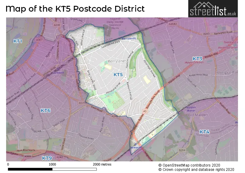
The KT5 Postcode shares a border with KT1 (KINGSTON UPON THAMES, HAMPTON WICK), KT3 (NEW MALDEN) and KT6 (SURBITON, TOLWORTH, LONG DITTON).
The primary settlement in the KT5 postcode district is Surbiton, located in Greater London. Surbiton has the highest count of postcodes in this district. There are no other significant settlements mentioned in the data for the KT5 district.
For the district KT5, we have data on 2 postcode sectors. Here's a breakdown: The sector KT5 8, covers Surbiton in Greater London. The sector KT5 9, covers Surbiton in Greater London.

Map of the KT5 Postcode District
Explore the KT5 postcode district by using our free interactive map.
When it comes to local government, postal geography often disregards political borders. However, for a breakdown in the KT5 District: the district mostly encompasses the Kingston upon Thames London Boro area with a total of 369 postcodes.
Recent House Sales in KT5
| Date | Price | Address |
|---|---|---|
| 18/09/2023 | £215,000 | Minstrel Gardens, Surbiton, KT5 8DD |
| 06/09/2023 | £835,000 | Greenfield Avenue, Surbiton, KT5 9HR |
| 05/09/2023 | £505,000 | Berrylands Road, Surbiton, KT5 8PE |
| 01/09/2023 | £355,000 | King Charles Road, Surbiton, KT5 8NY |
| 31/08/2023 | £744,000 | The Ridings, Surbiton, KT5 8HG |
| 31/08/2023 | £1,150,000 | Cranes Park Crescent, Surbiton, KT5 8AN |
| 25/08/2023 | £399,950 | Berrylands Road, Surbiton, KT5 8QX |
| 22/08/2023 | £465,000 | Knollmead, Surbiton, KT5 9QL |
| 18/08/2023 | £1,000,000 | Chiltern Drive, Surbiton, KT5 8LX |
| 18/08/2023 | £610,000 | Greenfield Avenue, Surbiton, KT5 9HR |
Weather Forecast for KT5
Press Button to Show Forecast for Kingston Upon Thames
| Time Period | Icon | Description | Temperature | Rain Probability | Wind |
|---|---|---|---|---|---|
| 03:00 to 06:00 | Partly cloudy (night) | 5.0°C (feels like 2.0°C) | 0.00% | NNW 7 mph | |
| 06:00 to 09:00 | Partly cloudy (day) | 5.0°C (feels like 2.0°C) | 1.00% | NNW 7 mph | |
| 09:00 to 12:00 | Cloudy | 8.0°C (feels like 5.0°C) | 3.00% | N 11 mph | |
| 12:00 to 15:00 | Cloudy | 11.0°C (feels like 8.0°C) | 4.00% | N 11 mph | |
| 15:00 to 18:00 | Cloudy | 12.0°C (feels like 9.0°C) | 4.00% | N 11 mph | |
| 18:00 to 21:00 | Cloudy | 11.0°C (feels like 9.0°C) | 4.00% | N 9 mph | |
| 21:00 to 00:00 | Cloudy | 8.0°C (feels like 7.0°C) | 4.00% | NNE 7 mph |
Press Button to Show Forecast for Kingston Upon Thames
| Time Period | Icon | Description | Temperature | Rain Probability | Wind |
|---|---|---|---|---|---|
| 00:00 to 03:00 | Cloudy | 7.0°C (feels like 5.0°C) | 5.00% | NNE 7 mph | |
| 03:00 to 06:00 | Cloudy | 6.0°C (feels like 4.0°C) | 5.00% | N 7 mph | |
| 06:00 to 09:00 | Cloudy | 6.0°C (feels like 3.0°C) | 5.00% | N 7 mph | |
| 09:00 to 12:00 | Overcast | 8.0°C (feels like 5.0°C) | 8.00% | NNE 9 mph | |
| 12:00 to 15:00 | Overcast | 10.0°C (feels like 8.0°C) | 8.00% | NNE 9 mph | |
| 15:00 to 18:00 | Cloudy | 12.0°C (feels like 9.0°C) | 6.00% | NNE 11 mph | |
| 18:00 to 21:00 | Partly cloudy (day) | 11.0°C (feels like 8.0°C) | 3.00% | NNE 11 mph | |
| 21:00 to 00:00 | Clear night | 8.0°C (feels like 6.0°C) | 2.00% | NNE 9 mph |
Press Button to Show Forecast for Kingston Upon Thames
| Time Period | Icon | Description | Temperature | Rain Probability | Wind |
|---|---|---|---|---|---|
| 00:00 to 03:00 | Partly cloudy (night) | 6.0°C (feels like 4.0°C) | 2.00% | NNE 7 mph | |
| 03:00 to 06:00 | Clear night | 5.0°C (feels like 3.0°C) | 2.00% | N 4 mph | |
| 06:00 to 09:00 | Sunny day | 5.0°C (feels like 3.0°C) | 3.00% | N 4 mph | |
| 09:00 to 12:00 | Cloudy | 8.0°C (feels like 6.0°C) | 7.00% | NNE 7 mph | |
| 12:00 to 15:00 | Cloudy | 10.0°C (feels like 8.0°C) | 9.00% | N 7 mph | |
| 15:00 to 18:00 | Overcast | 10.0°C (feels like 9.0°C) | 13.00% | NNW 7 mph | |
| 18:00 to 21:00 | Overcast | 10.0°C (feels like 8.0°C) | 15.00% | NNW 7 mph | |
| 21:00 to 00:00 | Light rain | 8.0°C (feels like 6.0°C) | 54.00% | NNW 4 mph |
Press Button to Show Forecast for Kingston Upon Thames
| Time Period | Icon | Description | Temperature | Rain Probability | Wind |
|---|---|---|---|---|---|
| 00:00 to 03:00 | Cloudy | 7.0°C (feels like 5.0°C) | 18.00% | ENE 4 mph | |
| 03:00 to 06:00 | Cloudy | 6.0°C (feels like 5.0°C) | 13.00% | NNW 4 mph | |
| 06:00 to 09:00 | Cloudy | 6.0°C (feels like 5.0°C) | 8.00% | NNE 4 mph | |
| 09:00 to 12:00 | Overcast | 9.0°C (feels like 7.0°C) | 12.00% | NNE 7 mph | |
| 12:00 to 15:00 | Cloudy | 11.0°C (feels like 9.0°C) | 14.00% | NNE 9 mph | |
| 15:00 to 18:00 | Overcast | 12.0°C (feels like 10.0°C) | 15.00% | NNE 9 mph | |
| 18:00 to 21:00 | Cloudy | 11.0°C (feels like 10.0°C) | 16.00% | NE 9 mph | |
| 21:00 to 00:00 | Clear night | 9.0°C (feels like 8.0°C) | 13.00% | NNE 7 mph |
Where is the KT5 Postcode District?
The postcode district KT5 is located in Surbiton. Surbiton is situated in close proximity to several nearby towns, including Tolworth to the south, New Malden to the northeast, Long Ditton to the west, Worcester Park to the southeast, Hampton Wick to the northwest, and Kingston upon Thames to the north. Surbiton is approximately 10.55 miles away from the center of London.
The district is within the post town of SURBITON.
The sector has postcodes within the nation of England.
The KT5 Postcode District is in the Merton, Kingston upon Thames and Sutton region of Outer London - South within the London.
| Postcode Sector | Delivery Office |
|---|---|
| KT5 8 | Kingston Upon Thames & Surbiton Delivery Office |
| KT5 9 | Kingston Upon Thames & Surbiton Delivery Office |
| K | T | 5 | - | X | X | X |
| K | T | 5 | Space | Numeric | Letter | Letter |
Current Monthly Rental Prices
| # Bedrooms | Min Price | Max Price | Avg Price |
|---|---|---|---|
| £850 | £2,000 | £1,200 | |
| 1 | £600 | £1,650 | £1,214 |
| 2 | £1,500 | £2,000 | £1,767 |
| 3 | £1,800 | £7,995 | £3,473 |
| 4 | £3,500 | £4,500 | £4,000 |
| 5 | £3,250 | £3,250 | £3,250 |
| 6 | £3,200 | £3,200 | £3,200 |
Current House Prices
| # Bedrooms | Min Price | Max Price | Avg Price |
|---|---|---|---|
| £45,000 | £300,000 | £216,667 | |
| 1 | £89,375 | £425,000 | £247,376 |
| 2 | £117,500 | £725,000 | £434,574 |
| 3 | £300,000 | £1,100,000 | £641,136 |
| 4 | £635,000 | £1,500,000 | £1,047,497 |
| 5 | £849,950 | £2,350,000 | £1,343,106 |
| 6 | £649,950 | £2,350,000 | £1,249,983 |
Estate Agents who Operate in the KT5 District
| Logo | Name | Brand Name | Address | Contact Number | Total Properties |
|---|---|---|---|---|---|
 | Surbiton | Dexters | 2 Claremont Road, Surbiton, KT6 4QU | 020 8390 6544 | 24 |
 | Surbiton | Greenfield Estate Agents | 13 Claremont Road, Surbiton, KT6 4QR | 020 3893 3405 | 12 |
 | Surbiton | Seymours Estate Agents | 13 Brighton Road, Surbiton, KT6 5LX | 020 3910 6352 | 11 |
 | Surbiton | Chancellors | 1-5 St. Marks Hill, Surbiton, KT6 4LH | 020 3879 5106 | 8 |
 | Surbiton | Barnard Marcus | 5A Surbiton Parade, St. Marks Hill, Surbiton, KT6 4RB | 020 3856 4123 | 8 |
| Type of Property | 2018 Average | 2018 Sales | 2017 Average | 2017 Sales | 2016 Average | 2016 Sales | 2015 Average | 2015 Sales |
|---|---|---|---|---|---|---|---|---|
| Detached | £877,220 | 28 | £845,600 | 25 | £833,423 | 26 | £856,530 | 32 |
| Semi-Detached | £654,976 | 95 | £675,414 | 124 | £669,601 | 105 | £589,253 | 121 |
| Terraced | £520,796 | 49 | £492,989 | 48 | £465,319 | 39 | £429,108 | 52 |
| Flats | £357,956 | 79 | £363,799 | 83 | £343,283 | 92 | £287,933 | 179 |
Hotels within the Postcode Area
We found 2 hotels and guest houses within the KT5 postcode area
The Angel Inn Hotel Surbiton
5 Howard Road, Surbiton, Kingston upon Thames, kingston-upon-thames, KT5 8SA.
View details