KY Kirkcaldy is a Postcode Area in the United Kingdom. The area code KY stands for the letters k and y in KirkcaldY. KY has a population of 364,238 and covers an area of 1,462,439 hectares. Fun fact: 0.56% of the population of Great Britain lives in this area.
The postcode sector falls within the following counties: Fife (95.85%), Perth and Kinross (4.11%), Clackmannan (0.03%).
Post Towns and Postcode Districts for the KY Postcode
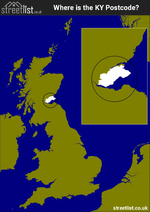
Where is the KY Postcode Area?
The KY Kirkcaldy Postcode is in Scotland. The postal area borders the following neighbouring postal areas: DD - Dundee, PH - Perth, FK - Falkirk and EH - Edinburgh, It also borders The North Sea and Firth of Forth.
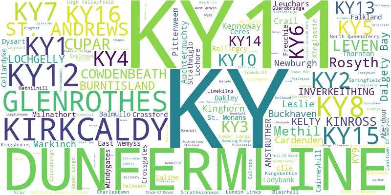
Postcode Districts within the KY Kirkcaldy Postcode Area
There are 16 postcode districts within the Kirkcaldy postcode area

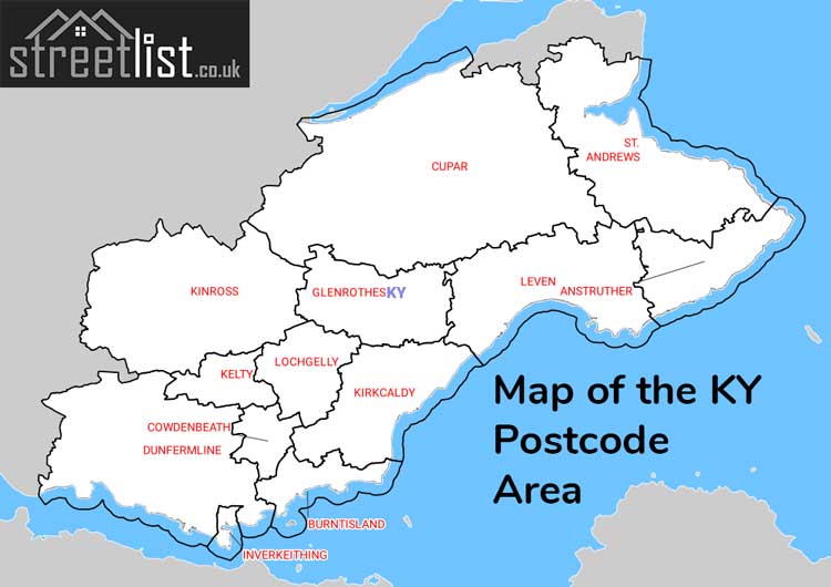
A map showing the boundary of in relation to other areas
Map of the KY Kirkcaldy Postcode Area
Explore the KY Kirkcaldy postcode area by using our free interactive map.
There are 19 towns within the Kirkcaldy postcode area.
| Unit | Area² |
|---|---|
| Hectares | 1,462,439² |
| Miles | 5,647² |
| Feet | 157,415,471,521² |
| Kilometres | 14,624² |
Postal Delivery Offices serving the KY Kirkcaldy Postcode Area
- Anstruther Delivery Office
- Burntisland Delivery Office
- Cowdenbeath Delivery Office
- Cupar Delivery Office
- Dunfermline Delivery Office
- Glenrothes Delivery Office
- Kinglassie Scale Payment Delivery Office
- Kinross Delivery Office
- Kirkcaldy Delivery Office
- Leven Delivery Office
- Limekilns Scale Payment Delivery Office
- Lochgelly Delivery Office
- Newmills Scale Payment Delivery Office
- Saline Scale Payment Delivery Office
- St Andrews Delivery Office
Councils with Postcodes in KY
Towns and Villages within the KY Kirkcaldy Postcode Area
- Aberdour - village
- Anstruther - town
- Arncroach - village
- Auchtermuchty - town
- Auchtertool - village
- Ballingry, Lochore and Crosshill -
- Balmullo - village
- Barnyards - village
- Blairhall - village
- Boarhills - village
- Bonnybank - village
- Buckhaven - town
- Burntisland - town
- Cairneyhill - village
- Cardenden and Auchterderran - village
- Carnock - village
- Ceres - village
- Cluny - village
- Coaltown of Balgonie - village
- Coaltown of Wemyss - village
- Colinsburgh - village
- Collessie - village
- Comrie (Fife) -
- Cowdenbeath and Lumphinnans -
- Craigrothie - village
- Crail - town
- Crombie - village
- Crook of Devon - village
- Crossford (Fife) -
- Crossgates - village
- Cupar - town
- Dalgety Bay - Settlement
- Drumoig - village
- Dunfermline - town
- Dunshalt - village
- East Wemyss - village
- Elie and Earlsferry -
- Falkland - town
- Fordell Firs - village
- Freuchie - village
- Gairney Bank - village
- Gateside - village
- Gauldry - village
- Glenrothes - town
- Gowkhall - village
- Grange of Lindores - village
- Guardbridge - village
- High Valleyfield, Low Valleyfield and Culross -
- Inverkeithing - town
- Kelty - village
- Kemback - village
- Kennoway - village
- Kilconquhar - village
- Kilmany - village
- Kilrenny - village
- Kinghorn - town
- Kinglassie - village
- Kingsbarns - village
- Kingseat (Fife) -
- Kingskettle and Kettlebridge -
- Kinnesswood - village
- Kinross - town
- Kirkcaldy and Dysart -
- Ladybank - town
- Largoward - village
- Leslie - town
- Letham - village
- Leuchars - village
- Leven -
- Limekilns and Charlestown -
- Lochgelly - town
- Lower Largo and Lundin Links -
- Markinch - town
- Methil - town
- Milnathort - village
- Milton of Balgonie - village
- Mount Melville - village
- Newbigging - village
- Newburgh (Fife) -
- Newton of Falkland - village
- North Queensferry - village
- Oakley -
- Osnaburgh / Dairsie - village
- Pitlessie - village
- Pitscottie - village
- Pittenweem - town
- Powmill - village
- Rosyth - Settlement
- Rumbling Bridge - village
- Saline - village
- Scotlandwell - village
- Springfield -
- St Andrews - town
- St Monans -
- Star - village
- Steelend - village
- Strathkinness - village
- Strathmiglo - village
- Strathore - otherSettlement
- Thornton -
- Torryburn and Newmills -
- Townhill -
- Upper Largo / Kirkton of Largo - village
- West Wemyss - village
- Wester Balgedie - village
- Windygates - village