The L10 6 postcode sector is within the county of Merseyside.
Did you know? According to the 2021 Census, the L10 6 postcode sector is home to a bustling 1,347 residents!
Given that each sector allows for 400 unique postcode combinations. Letters C, I, K, M, O and V are not allowed in the last two letters of a postcode. With 28 postcodes already in use, this leaves 372 units available.
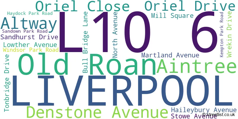
The largest settlement in the L10 6 postal code is LIVERPOOL followed by Aintree, and Old Roan.
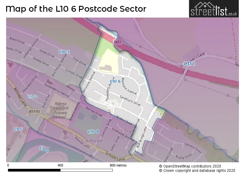
The L10 6 Postcode shares a border with L31 1 (Melling, Maghull, LIVERPOOL), L10 2 (LIVERPOOL, Old Roan), L10 3 (LIVERPOOL, Aintree) and L10 8 (LIVERPOOL, Aintree).
The sector is within the post town of LIVERPOOL.
L10 6 is a postcode sector within the L10 postcode district which is within the L Liverpool postcode area.
The Royal Mail delivery office for the L10 6 postal sector is the Walton (l) Delivery Office.
The area of the L10 6 postcode sector is 0.11 square miles which is 0.29 square kilometres or 71.81 square acres.
The L10 6 postcode sector is crossed by the M57 motorway.
Waterways within the L10 6 postcode sector include the River Alt.

Map of the L10 6 Postcode Sector
Explore the L10 6 postcode sector by using our free interactive map.
| L | 1 | 0 | - | 6 | X | X |
| L | 1 | 0 | Space | 6 | Letter | Letter |
Official List of Streets
LIVERPOOL (15 Streets)
Aintree (2 Streets)
Old Roan (1 Streets)
Unofficial Streets or Alternative Spellings
Weather Forecast for L10 6
Press Button to Show Forecast for Aintree
| Time Period | Icon | Description | Temperature | Rain Probability | Wind |
|---|---|---|---|---|---|
| 03:00 to 06:00 | Partly cloudy (night) | 6.0°C (feels like 5.0°C) | 0.00% | SSE 2 mph | |
| 06:00 to 09:00 | Partly cloudy (day) | 6.0°C (feels like 5.0°C) | 1.00% | SSE 2 mph | |
| 09:00 to 12:00 | Partly cloudy (day) | 9.0°C (feels like 8.0°C) | 1.00% | W 2 mph | |
| 12:00 to 15:00 | Partly cloudy (day) | 11.0°C (feels like 10.0°C) | 0.00% | NW 7 mph | |
| 15:00 to 18:00 | Partly cloudy (day) | 11.0°C (feels like 9.0°C) | 0.00% | NW 9 mph | |
| 18:00 to 21:00 | Cloudy | 10.0°C (feels like 8.0°C) | 3.00% | NNW 7 mph | |
| 21:00 to 00:00 | Partly cloudy (night) | 9.0°C (feels like 8.0°C) | 0.00% | NNW 4 mph |
Press Button to Show Forecast for Aintree
| Time Period | Icon | Description | Temperature | Rain Probability | Wind |
|---|---|---|---|---|---|
| 00:00 to 03:00 | Partly cloudy (night) | 8.0°C (feels like 8.0°C) | 0.00% | NNW 4 mph | |
| 03:00 to 06:00 | Cloudy | 8.0°C (feels like 7.0°C) | 4.00% | SW 4 mph | |
| 06:00 to 09:00 | Cloudy | 8.0°C (feels like 6.0°C) | 13.00% | S 4 mph | |
| 09:00 to 12:00 | Overcast | 9.0°C (feels like 8.0°C) | 14.00% | NNE 7 mph | |
| 12:00 to 15:00 | Cloudy | 10.0°C (feels like 9.0°C) | 7.00% | ENE 7 mph | |
| 15:00 to 18:00 | Cloudy | 11.0°C (feels like 10.0°C) | 7.00% | NE 7 mph | |
| 18:00 to 21:00 | Cloudy | 11.0°C (feels like 9.0°C) | 7.00% | NE 7 mph | |
| 21:00 to 00:00 | Cloudy | 9.0°C (feels like 8.0°C) | 6.00% | ENE 7 mph |
Press Button to Show Forecast for Aintree
| Time Period | Icon | Description | Temperature | Rain Probability | Wind |
|---|---|---|---|---|---|
| 00:00 to 03:00 | Overcast | 8.0°C (feels like 6.0°C) | 11.00% | ESE 7 mph | |
| 03:00 to 06:00 | Overcast | 7.0°C (feels like 6.0°C) | 11.00% | SSE 7 mph | |
| 06:00 to 09:00 | Overcast | 7.0°C (feels like 5.0°C) | 11.00% | S 7 mph | |
| 09:00 to 12:00 | Light rain | 8.0°C (feels like 7.0°C) | 47.00% | S 7 mph | |
| 12:00 to 15:00 | Cloudy | 10.0°C (feels like 8.0°C) | 10.00% | NNE 7 mph | |
| 15:00 to 18:00 | Cloudy | 11.0°C (feels like 9.0°C) | 9.00% | NNE 9 mph | |
| 18:00 to 21:00 | Cloudy | 11.0°C (feels like 9.0°C) | 15.00% | NE 9 mph | |
| 21:00 to 00:00 | Light rain | 10.0°C (feels like 8.0°C) | 49.00% | ENE 7 mph |
Press Button to Show Forecast for Aintree
| Time Period | Icon | Description | Temperature | Rain Probability | Wind |
|---|---|---|---|---|---|
| 00:00 to 03:00 | Cloudy | 9.0°C (feels like 8.0°C) | 5.00% | ESE 4 mph | |
| 03:00 to 06:00 | Overcast | 9.0°C (feels like 7.0°C) | 8.00% | ENE 7 mph | |
| 06:00 to 09:00 | Overcast | 8.0°C (feels like 7.0°C) | 8.00% | E 7 mph | |
| 09:00 to 12:00 | Partly cloudy (day) | 10.0°C (feels like 8.0°C) | 3.00% | NNE 7 mph | |
| 12:00 to 15:00 | Cloudy | 11.0°C (feels like 9.0°C) | 5.00% | NE 9 mph | |
| 15:00 to 18:00 | Cloudy | 12.0°C (feels like 9.0°C) | 5.00% | NNW 11 mph | |
| 18:00 to 21:00 | Partly cloudy (day) | 11.0°C (feels like 9.0°C) | 2.00% | NNW 11 mph | |
| 21:00 to 00:00 | Clear night | 9.0°C (feels like 7.0°C) | 1.00% | N 9 mph |
Schools and Places of Education Within the L10 6 Postcode Sector
Holy Rosary Catholic Primary School
Voluntary aided school
Oriel Drive, Liverpool, Merseyside, L10 6NJ
Head: Mrs M Stevenson
Ofsted Rating: Outstanding
Inspection: 2014-02-06 (3726 days ago)
Website: Visit Holy Rosary Catholic Primary School Website
Phone: 01512886206
Number of Pupils: 460
House Prices in the L10 6 Postcode Sector
| Type of Property | 2018 Average | 2018 Sales | 2017 Average | 2017 Sales | 2016 Average | 2016 Sales | 2015 Average | 2015 Sales |
|---|---|---|---|---|---|---|---|---|
| Detached | £284,000 | 1 | £0 | 0 | £0 | 0 | £165,000 | 1 |
| Semi-Detached | £170,115 | 13 | £160,050 | 10 | £154,682 | 14 | £146,954 | 13 |
| Terraced | £159,975 | 2 | £189,817 | 3 | £129,667 | 3 | £0 | 0 |
| Flats | £80,000 | 1 | £102,000 | 1 | £0 | 0 | £0 | 0 |
Important Postcodes L10 6 in the Postcode Sector
L10 6NJ is the postcode for Holy Rosary Catholic Primary School, Oriel Drive, Oriel Drive Medical Centre, Oriel Drive, and AINTREE YOUTH CENTRE, ORIEL DRIVE
| The L10 6 Sector is within these Local Authorities |
|
|---|---|
| The L10 6 Sector is within these Counties |
|
| The L10 6 Sector is within these Water Company Areas |
|