The L12 0 postcode sector is within the county of Merseyside.
Did you know? According to the 2021 Census, the L12 0 postcode sector is home to a bustling 9,330 residents!
Given that each sector allows for 400 unique postcode combinations. Letters C, I, K, M, O and V are not allowed in the last two letters of a postcode. With 168 postcodes already in use, this leaves 232 units available.
The largest settlements in the L12 0 postal code are LIVERPOOL and West Derby.
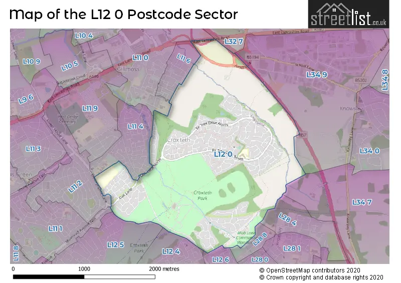
The L12 0 Postcode shares a border with L11 0 (LIVERPOOL, Gilmoss Industrial Estate, West Derby), L11 6 (LIVERPOOL, Croxteth), L12 4 (LIVERPOOL, West Derby), L32 7 (LIVERPOOL, Kirkby), L28 4 (LIVERPOOL), L28 8 (LIVERPOOL), L12 5 (LIVERPOOL, West Derby), L12 6 (LIVERPOOL), L11 1 (LIVERPOOL, Norris Green), L11 2 (LIVERPOOL, West Derby), L11 4 (LIVERPOOL, Croxteth), L34 7 (Knowsley) and L34 9 (Knowsley, Knowsley Business Park).
The sector is within the post town of LIVERPOOL.
L12 0 is a postcode sector within the L12 postcode district which is within the L Liverpool postcode area.
The Royal Mail delivery office for the L12 0 postal sector is the West Derby Delivery Office.
The area of the L12 0 postcode sector is 1.88 square miles which is 4.87 square kilometres or 1,202.72 square acres.
The L12 0 postcode sector is crossed by the M57 motorway.

Map of the L12 0 Postcode Sector
Explore the L12 0 postcode sector by using our free interactive map.
| L | 1 | 2 | - | 0 | X | X |
| L | 1 | 2 | Space | 0 | Letter | Letter |
Official List of Streets
LIVERPOOL (135 Streets)
West Derby (18 Streets)
Unofficial Streets or Alternative Spellings
Glazebury
EAST LANCASHIRE ROADLIVERPOOL
DEYSBROOK LANE DWERRYHOUSE LANE ELWICK DRIVE EXFORD ROAD MAB LANE PARKVIEW ROAD SPRINGFIELD WAY TINTAGEL ROADWest Derby
BERKLEY AVENUEKnowsley
GELLINGS LANE GELLINGS BRIDLEWAY MISTLETHRUSH WAY OAK LANE OAK LANE NORTH RANDLES FARM INTERCHANGE SAINT CUTHBERTS CLOSECroxteth
CROXTETH HALL LANEWeather Forecast for L12 0
Press Button to Show Forecast for Croxteth Hall
| Time Period | Icon | Description | Temperature | Rain Probability | Wind |
|---|---|---|---|---|---|
| 12:00 to 15:00 | Light rain shower (day) | 9.0°C (feels like 7.0°C) | 33.00% | N 9 mph | |
| 15:00 to 18:00 | Cloudy | 9.0°C (feels like 7.0°C) | 13.00% | N 9 mph | |
| 18:00 to 21:00 | Cloudy | 8.0°C (feels like 6.0°C) | 8.00% | NW 7 mph | |
| 21:00 to 00:00 | Cloudy | 7.0°C (feels like 5.0°C) | 5.00% | ENE 7 mph |
Press Button to Show Forecast for Croxteth Hall
| Time Period | Icon | Description | Temperature | Rain Probability | Wind |
|---|---|---|---|---|---|
| 00:00 to 03:00 | Partly cloudy (night) | 6.0°C (feels like 4.0°C) | 2.00% | E 7 mph | |
| 03:00 to 06:00 | Clear night | 4.0°C (feels like 2.0°C) | 1.00% | E 7 mph | |
| 06:00 to 09:00 | Sunny day | 4.0°C (feels like 2.0°C) | 2.00% | E 7 mph | |
| 09:00 to 12:00 | Cloudy | 7.0°C (feels like 5.0°C) | 5.00% | E 4 mph | |
| 12:00 to 15:00 | Cloudy | 9.0°C (feels like 8.0°C) | 6.00% | NE 4 mph | |
| 15:00 to 18:00 | Cloudy | 9.0°C (feels like 8.0°C) | 6.00% | N 4 mph | |
| 18:00 to 21:00 | Partly cloudy (day) | 9.0°C (feels like 7.0°C) | 3.00% | NNE 7 mph | |
| 21:00 to 00:00 | Cloudy | 7.0°C (feels like 5.0°C) | 7.00% | NE 9 mph |
Press Button to Show Forecast for Croxteth Hall
| Time Period | Icon | Description | Temperature | Rain Probability | Wind |
|---|---|---|---|---|---|
| 00:00 to 03:00 | Partly cloudy (night) | 5.0°C (feels like 3.0°C) | 4.00% | ESE 9 mph | |
| 03:00 to 06:00 | Partly cloudy (night) | 4.0°C (feels like 2.0°C) | 6.00% | ESE 7 mph | |
| 06:00 to 09:00 | Partly cloudy (day) | 5.0°C (feels like 2.0°C) | 4.00% | E 7 mph | |
| 09:00 to 12:00 | Cloudy | 8.0°C (feels like 6.0°C) | 8.00% | ESE 7 mph | |
| 12:00 to 15:00 | Overcast | 10.0°C (feels like 9.0°C) | 12.00% | E 7 mph | |
| 15:00 to 18:00 | Overcast | 10.0°C (feels like 9.0°C) | 18.00% | NE 7 mph | |
| 18:00 to 21:00 | Cloudy | 10.0°C (feels like 8.0°C) | 13.00% | ENE 9 mph | |
| 21:00 to 00:00 | Cloudy | 8.0°C (feels like 6.0°C) | 13.00% | NE 9 mph |
Press Button to Show Forecast for Croxteth Hall
| Time Period | Icon | Description | Temperature | Rain Probability | Wind |
|---|---|---|---|---|---|
| 00:00 to 03:00 | Light rain | 6.0°C (feels like 4.0°C) | 45.00% | NE 9 mph | |
| 03:00 to 06:00 | Cloudy | 6.0°C (feels like 3.0°C) | 15.00% | NNE 11 mph | |
| 06:00 to 09:00 | Light rain | 7.0°C (feels like 4.0°C) | 49.00% | NNE 11 mph | |
| 09:00 to 12:00 | Light rain | 8.0°C (feels like 5.0°C) | 49.00% | NNE 11 mph | |
| 12:00 to 15:00 | Light rain | 9.0°C (feels like 6.0°C) | 53.00% | N 11 mph | |
| 15:00 to 18:00 | Heavy rain | 10.0°C (feels like 7.0°C) | 70.00% | N 11 mph | |
| 18:00 to 21:00 | Partly cloudy (day) | 10.0°C (feels like 8.0°C) | 14.00% | NNW 11 mph | |
| 21:00 to 00:00 | Partly cloudy (night) | 9.0°C (feels like 7.0°C) | 9.00% | NW 9 mph |
Schools and Places of Education Within the L12 0 Postcode Sector
Emmaus Church of England and Catholic Primary School
Voluntary aided school
Fir Tree Drive South, LIVERPOOL, Merseyside, L12 0JE
Head: Mr Alan Williams
Ofsted Rating: Outstanding
Inspection: 2023-11-29 (148 days ago)
Website: Visit Emmaus Church of England and Catholic Primary School Website
Phone: 01512331414
Number of Pupils: 477
House Prices in the L12 0 Postcode Sector
| Type of Property | 2018 Average | 2018 Sales | 2017 Average | 2017 Sales | 2016 Average | 2016 Sales | 2015 Average | 2015 Sales |
|---|---|---|---|---|---|---|---|---|
| Detached | £200,568 | 53 | £189,695 | 61 | £184,075 | 65 | £184,007 | 60 |
| Semi-Detached | £132,116 | 47 | £127,605 | 40 | £125,837 | 59 | £118,536 | 52 |
| Terraced | £96,929 | 14 | £87,994 | 9 | £95,045 | 11 | £93,297 | 18 |
| Flats | £45,000 | 1 | £112,050 | 2 | £28,500 | 1 | £34,625 | 2 |
Important Postcodes L12 0 in the Postcode Sector
L12 0HB is the postcode for Croxteth Hall & Country Park, Croxteth Park, and CROXTETH HALL, CROXTETH HALL LANE, CROXTETH
L12 0JE is the postcode for Fir Tree Drive South Medical Centre, 103 Fir Tree Drive South, and Emmaus Primary School, Fir Tree Drive South
| The L12 0 Sector is within these Local Authorities |
|
|---|---|
| The L12 0 Sector is within these Counties |
|
| The L12 0 Sector is within these Water Company Areas |
|