The L12 1 postcode sector is within the county of Merseyside.
Did you know? According to the 2021 Census, the L12 1 postcode sector is home to a bustling 1,079 residents!
Given that each sector allows for 400 unique postcode combinations. Letters C, I, K, M, O and V are not allowed in the last two letters of a postcode. With 31 postcodes already in use, this leaves 369 units available.
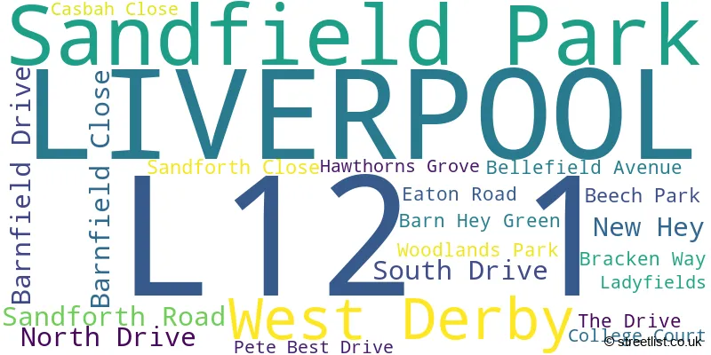
The largest settlement in the L12 1 postal code is LIVERPOOL followed by West Derby, and Sandfield Park.
The L12 1 Postcode shares a border with L12 7 (LIVERPOOL, West Derby), L12 8 (LIVERPOOL, West Derby), L12 2 (West Derby, LIVERPOOL, Sandfield Park) and L13 0 (LIVERPOOL, West Derby, Stoneycroft).
The sector is within the post town of LIVERPOOL.
L12 1 is a postcode sector within the L12 postcode district which is within the L Liverpool postcode area.
The Royal Mail delivery office for the L12 1 postal sector is the West Derby Delivery Office.
The area of the L12 1 postcode sector is 0.17 square miles which is 0.45 square kilometres or 110.40 square acres.

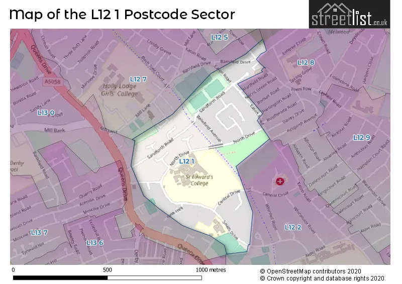
Map of the L12 1 Postcode Sector
Explore the L12 1 postcode sector by using our free interactive map.
| L | 1 | 2 | - | 1 | X | X |
| L | 1 | 2 | Space | 1 | Letter | Letter |
Official List of Streets
LIVERPOOL (12 Streets)
West Derby (4 Streets)
Sandfield Park (3 Streets)
Unofficial Streets or Alternative Spellings
Weather Forecast for L12 1
Press Button to Show Forecast for West Derby
| Time Period | Icon | Description | Temperature | Rain Probability | Wind |
|---|---|---|---|---|---|
| 15:00 to 18:00 | Heavy rain | 8.0°C (feels like 5.0°C) | 90.00% | WSW 13 mph | |
| 18:00 to 21:00 | Heavy rain | 10.0°C (feels like 7.0°C) | 76.00% | WSW 16 mph | |
| 21:00 to 00:00 | Light rain | 10.0°C (feels like 6.0°C) | 54.00% | W 16 mph |
Press Button to Show Forecast for West Derby
| Time Period | Icon | Description | Temperature | Rain Probability | Wind |
|---|---|---|---|---|---|
| 00:00 to 03:00 | Cloudy | 10.0°C (feels like 6.0°C) | 54.00% | WNW 18 mph | |
| 03:00 to 06:00 | Light rain shower (night) | 9.0°C (feels like 6.0°C) | 35.00% | WNW 18 mph | |
| 06:00 to 09:00 | Cloudy | 9.0°C (feels like 5.0°C) | 8.00% | NW 16 mph | |
| 09:00 to 12:00 | Cloudy | 10.0°C (feels like 6.0°C) | 5.00% | NW 20 mph | |
| 12:00 to 15:00 | Cloudy | 10.0°C (feels like 7.0°C) | 5.00% | NW 20 mph | |
| 15:00 to 18:00 | Cloudy | 11.0°C (feels like 8.0°C) | 4.00% | NW 18 mph | |
| 18:00 to 21:00 | Cloudy | 10.0°C (feels like 7.0°C) | 4.00% | NNW 13 mph | |
| 21:00 to 00:00 | Cloudy | 9.0°C (feels like 7.0°C) | 5.00% | N 9 mph |
Press Button to Show Forecast for West Derby
| Time Period | Icon | Description | Temperature | Rain Probability | Wind |
|---|---|---|---|---|---|
| 00:00 to 03:00 | Overcast | 7.0°C (feels like 6.0°C) | 7.00% | NE 7 mph | |
| 03:00 to 06:00 | Cloudy | 6.0°C (feels like 5.0°C) | 5.00% | ESE 4 mph | |
| 06:00 to 09:00 | Partly cloudy (day) | 6.0°C (feels like 5.0°C) | 2.00% | ENE 4 mph | |
| 09:00 to 12:00 | Partly cloudy (day) | 8.0°C (feels like 6.0°C) | 2.00% | NE 4 mph | |
| 12:00 to 15:00 | Partly cloudy (day) | 9.0°C (feels like 8.0°C) | 2.00% | NNW 7 mph | |
| 15:00 to 18:00 | Partly cloudy (day) | 10.0°C (feels like 8.0°C) | 1.00% | NW 7 mph | |
| 18:00 to 21:00 | Sunny day | 10.0°C (feels like 8.0°C) | 1.00% | NNW 7 mph | |
| 21:00 to 00:00 | Clear night | 9.0°C (feels like 7.0°C) | 1.00% | NNW 4 mph |
Press Button to Show Forecast for West Derby
| Time Period | Icon | Description | Temperature | Rain Probability | Wind |
|---|---|---|---|---|---|
| 00:00 to 03:00 | Clear night | 8.0°C (feels like 6.0°C) | 1.00% | N 4 mph | |
| 03:00 to 06:00 | Partly cloudy (night) | 7.0°C (feels like 6.0°C) | 1.00% | NW 4 mph | |
| 06:00 to 09:00 | Partly cloudy (day) | 7.0°C (feels like 6.0°C) | 1.00% | NNW 4 mph | |
| 09:00 to 12:00 | Cloudy | 10.0°C (feels like 8.0°C) | 4.00% | NW 7 mph | |
| 12:00 to 15:00 | Cloudy | 11.0°C (feels like 10.0°C) | 4.00% | N 7 mph | |
| 15:00 to 18:00 | Cloudy | 12.0°C (feels like 10.0°C) | 8.00% | N 7 mph | |
| 18:00 to 21:00 | Light rain | 12.0°C (feels like 10.0°C) | 38.00% | NE 7 mph | |
| 21:00 to 00:00 | Partly cloudy (night) | 10.0°C (feels like 8.0°C) | 1.00% | NE 7 mph |
Press Button to Show Forecast for West Derby
| Time Period | Icon | Description | Temperature | Rain Probability | Wind |
|---|---|---|---|---|---|
| 00:00 to 03:00 | Partly cloudy (night) | 8.0°C (feels like 6.0°C) | 2.00% | ENE 7 mph | |
| 03:00 to 06:00 | Cloudy | 7.0°C (feels like 5.0°C) | 6.00% | ENE 7 mph | |
| 06:00 to 09:00 | Cloudy | 7.0°C (feels like 5.0°C) | 6.00% | ENE 7 mph | |
| 09:00 to 12:00 | Cloudy | 9.0°C (feels like 7.0°C) | 6.00% | ENE 7 mph | |
| 12:00 to 15:00 | Light rain | 10.0°C (feels like 8.0°C) | 37.00% | ENE 9 mph | |
| 15:00 to 18:00 | Cloudy | 11.0°C (feels like 9.0°C) | 15.00% | ENE 9 mph | |
| 18:00 to 21:00 | Overcast | 11.0°C (feels like 9.0°C) | 11.00% | NNE 9 mph | |
| 21:00 to 00:00 | Cloudy | 9.0°C (feels like 8.0°C) | 7.00% | ENE 7 mph |
Schools and Places of Education Within the L12 1 Postcode Sector
Runnymede St Edward's Catholic Primary School
Voluntary aided school
North Drive, Liverpool, Merseyside, L12 1LE
Head: Miss Kate Peaston
Ofsted Rating: Good
Inspection: 2023-03-22 (393 days ago)
Website: Visit Runnymede St Edward's Catholic Primary School Website
Phone: 01512812300
Number of Pupils: 303
Sandfield Park School
Community special school
South Drive, Liverpool, Merseyside, L12 1LH
Head: Mr Mark Hilton
Ofsted Rating: Good
Inspection: 2019-03-19 (1857 days ago)
Website: Visit Sandfield Park School Website
Phone: 01512280324
Number of Pupils: 91
St Edward's College
Academy converter
Sandfield Park, Liverpool, Merseyside, L12 1LF
Head: Mr Stephen Morris
Ofsted Rating: Requires improvement
Inspection: 2022-11-09 (526 days ago)
Website: Visit St Edward's College Website
Phone: 01512811999
Number of Pupils: 1172
House Prices in the L12 1 Postcode Sector
| Type of Property | 2018 Average | 2018 Sales | 2017 Average | 2017 Sales | 2016 Average | 2016 Sales | 2015 Average | 2015 Sales |
|---|---|---|---|---|---|---|---|---|
| Detached | £428,500 | 8 | £410,000 | 2 | £394,748 | 9 | £440,745 | 33 |
| Semi-Detached | £164,975 | 2 | £183,750 | 4 | £240,000 | 1 | £165,900 | 5 |
| Terraced | £0 | 0 | £55,000 | 1 | £118,500 | 2 | £117,000 | 1 |
| Flats | £100,833 | 3 | £185,725 | 5 | £149,000 | 1 | £182,661 | 7 |
Important Postcodes L12 1 in the Postcode Sector
L12 1LE is the postcode for RUNNYMEDE ST EDWARDS SCHOOL, NORTH DRIVE, SANDFIELD PARK
L12 1LF is the postcode for THE FOLEY BUILDING, St. Edwards College, North Drive, CDT, St. Edwards College, North Drive, ST CLARE, St. Edwards College, North Drive, St. Edwards College, North Drive, Sandfield Park, St. Edwards College, North Drive, and THE JOHN MORGAN SPORTS COMPLEX, St. Edwards College, North Drive
L12 1LH is the postcode for Sandfield Park School, South Drive, Sandfield Park, and Sandfield Park School, South Drive
| The L12 1 Sector is within these Local Authorities |
|
|---|---|
| The L12 1 Sector is within these Counties |
|
| The L12 1 Sector is within these Water Company Areas |
|