The L12 6 postcode sector is within the county of Merseyside.
Did you know? According to the 2021 Census, the L12 6 postcode sector is home to a bustling 1,989 residents!
Given that each sector allows for 400 unique postcode combinations. Letters C, I, K, M, O and V are not allowed in the last two letters of a postcode. With 37 postcodes already in use, this leaves 363 units available.
The L12 6 postal code covers the settlement of LIVERPOOL.
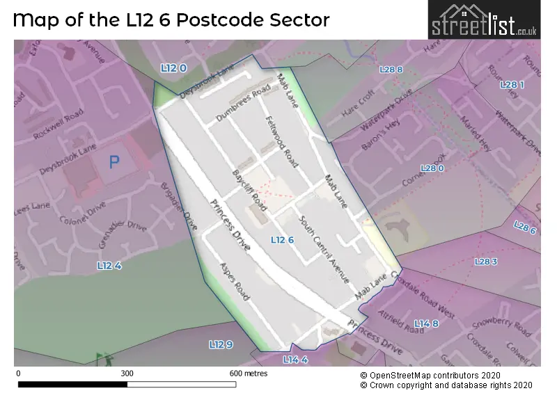
The L12 6 Postcode shares a border with L12 4 (LIVERPOOL, West Derby), L28 8 (LIVERPOOL), L12 9 (LIVERPOOL, West Derby), L12 0 (LIVERPOOL, West Derby), L14 4 (LIVERPOOL, Knotty Ash), L14 8 (LIVERPOOL), L28 3 (LIVERPOOL) and L28 0 (LIVERPOOL).
The sector is within the post town of LIVERPOOL.
L12 6 is a postcode sector within the L12 postcode district which is within the L Liverpool postcode area.
The Royal Mail delivery office for the L12 6 postal sector is the West Derby Delivery Office.
The area of the L12 6 postcode sector is 0.13 square miles which is 0.34 square kilometres or 84.35 square acres.

Map of the L12 6 Postcode Sector
Explore the L12 6 postcode sector by using our free interactive map.
| L | 1 | 2 | - | 6 | X | X |
| L | 1 | 2 | Space | 6 | Letter | Letter |
Official List of Streets
LIVERPOOL (19 Streets)
Unofficial Streets or Alternative Spellings
LIVERPOOL
BRIGADIER DRIVE COACHMANS DRIVE CORNER BROOK CROXDALE ROAD WEST WATERPARK DRIVEKnotty Ash
FINCH LANEWeather Forecast for L12 6
Press Button to Show Forecast for Croxteth Hall
| Time Period | Icon | Description | Temperature | Rain Probability | Wind |
|---|---|---|---|---|---|
| 03:00 to 06:00 | Light rain shower (night) | 9.0°C (feels like 6.0°C) | 43.00% | WNW 18 mph | |
| 06:00 to 09:00 | Cloudy | 9.0°C (feels like 5.0°C) | 9.00% | NW 18 mph | |
| 09:00 to 12:00 | Cloudy | 10.0°C (feels like 6.0°C) | 4.00% | NW 20 mph | |
| 12:00 to 15:00 | Partly cloudy (day) | 10.0°C (feels like 7.0°C) | 1.00% | NW 20 mph | |
| 15:00 to 18:00 | Partly cloudy (day) | 11.0°C (feels like 8.0°C) | 3.00% | NW 18 mph | |
| 18:00 to 21:00 | Cloudy | 10.0°C (feels like 7.0°C) | 4.00% | NNW 13 mph | |
| 21:00 to 00:00 | Cloudy | 9.0°C (feels like 7.0°C) | 4.00% | N 9 mph |
Press Button to Show Forecast for Croxteth Hall
| Time Period | Icon | Description | Temperature | Rain Probability | Wind |
|---|---|---|---|---|---|
| 00:00 to 03:00 | Overcast | 7.0°C (feels like 6.0°C) | 7.00% | ENE 7 mph | |
| 03:00 to 06:00 | Cloudy | 6.0°C (feels like 5.0°C) | 5.00% | E 4 mph | |
| 06:00 to 09:00 | Cloudy | 6.0°C (feels like 4.0°C) | 5.00% | ENE 4 mph | |
| 09:00 to 12:00 | Partly cloudy (day) | 8.0°C (feels like 6.0°C) | 2.00% | NE 4 mph | |
| 12:00 to 15:00 | Cloudy | 9.0°C (feels like 8.0°C) | 5.00% | NNW 7 mph | |
| 15:00 to 18:00 | Partly cloudy (day) | 10.0°C (feels like 8.0°C) | 2.00% | NW 9 mph | |
| 18:00 to 21:00 | Sunny day | 9.0°C (feels like 8.0°C) | 1.00% | NW 7 mph | |
| 21:00 to 00:00 | Clear night | 8.0°C (feels like 7.0°C) | 1.00% | NNW 4 mph |
Press Button to Show Forecast for Croxteth Hall
| Time Period | Icon | Description | Temperature | Rain Probability | Wind |
|---|---|---|---|---|---|
| 00:00 to 03:00 | Clear night | 7.0°C (feels like 6.0°C) | 1.00% | NNW 4 mph | |
| 03:00 to 06:00 | Partly cloudy (night) | 7.0°C (feels like 5.0°C) | 1.00% | NW 4 mph | |
| 06:00 to 09:00 | Cloudy | 7.0°C (feels like 6.0°C) | 4.00% | NE 4 mph | |
| 09:00 to 12:00 | Overcast | 10.0°C (feels like 8.0°C) | 7.00% | NW 7 mph | |
| 12:00 to 15:00 | Cloudy | 11.0°C (feels like 9.0°C) | 4.00% | NNW 7 mph | |
| 15:00 to 18:00 | Cloudy | 12.0°C (feels like 10.0°C) | 8.00% | NNW 7 mph | |
| 18:00 to 21:00 | Light rain | 11.0°C (feels like 10.0°C) | 37.00% | NNE 7 mph | |
| 21:00 to 00:00 | Partly cloudy (night) | 9.0°C (feels like 8.0°C) | 1.00% | NE 7 mph |
Press Button to Show Forecast for Croxteth Hall
| Time Period | Icon | Description | Temperature | Rain Probability | Wind |
|---|---|---|---|---|---|
| 00:00 to 03:00 | Cloudy | 8.0°C (feels like 6.0°C) | 4.00% | NE 7 mph | |
| 03:00 to 06:00 | Cloudy | 7.0°C (feels like 5.0°C) | 6.00% | ENE 7 mph | |
| 06:00 to 09:00 | Cloudy | 7.0°C (feels like 5.0°C) | 6.00% | ENE 7 mph | |
| 09:00 to 12:00 | Cloudy | 9.0°C (feels like 7.0°C) | 6.00% | ENE 7 mph | |
| 12:00 to 15:00 | Light rain | 10.0°C (feels like 8.0°C) | 38.00% | ENE 9 mph | |
| 15:00 to 18:00 | Cloudy | 11.0°C (feels like 9.0°C) | 15.00% | NE 9 mph | |
| 18:00 to 21:00 | Overcast | 11.0°C (feels like 9.0°C) | 11.00% | NNE 9 mph | |
| 21:00 to 00:00 | Cloudy | 9.0°C (feels like 7.0°C) | 6.00% | ENE 7 mph |
Schools and Places of Education Within the L12 6 Postcode Sector
Mab Lane Junior Mixed and Infant School
Community school
Mab Lane, Liverpool, Merseyside, L12 6QL
Head: Mrs Laura Tracey
Ofsted Rating: Good
Inspection: 2020-01-15 (1556 days ago)
Website: Visit Mab Lane Junior Mixed and Infant School Website
Phone: 01512594282
Number of Pupils: 312
House Prices in the L12 6 Postcode Sector
| Type of Property | 2018 Average | 2018 Sales | 2017 Average | 2017 Sales | 2016 Average | 2016 Sales | 2015 Average | 2015 Sales |
|---|---|---|---|---|---|---|---|---|
| Detached | £0 | 0 | £0 | 0 | £0 | 0 | £0 | 0 |
| Semi-Detached | £117,133 | 9 | £116,000 | 1 | £0 | 0 | £96,250 | 4 |
| Terraced | £94,545 | 11 | £83,700 | 5 | £82,000 | 10 | £67,820 | 10 |
| Flats | £71,625 | 4 | £66,333 | 3 | £51,500 | 6 | £49,118 | 5 |
Important Postcodes L12 6 in the Postcode Sector
L12 6QL is the postcode for Mab Lane Jmi School, Mab Lane
| The L12 6 Sector is within these Local Authorities |
|
|---|---|
| The L12 6 Sector is within these Counties |
|
| The L12 6 Sector is within these Water Company Areas |
|