The L13 postcode district is a postal district located in the L Liverpool postcode area with a population of 29,865 residents according to the 2021 England and Wales Census.
The area of the L13 postcode district is 2.01 square miles which is 5.21 square kilometres or 1,286.39 acres.
Currently, the L13 district has about 562 postcode units spread across 10 geographic postcode sectors.
Given that each sector allows for 400 unique postcode combinations, the district has a capacity of 4,000 postcodes. With 562 postcodes already in use, this leaves 3438 units available.
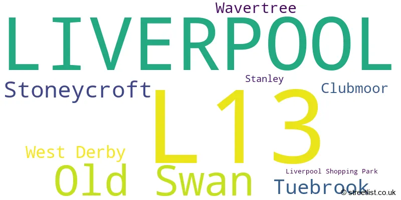
The largest settlement in the L13 postal code is LIVERPOOL followed by Old Swan, and Tuebrook.
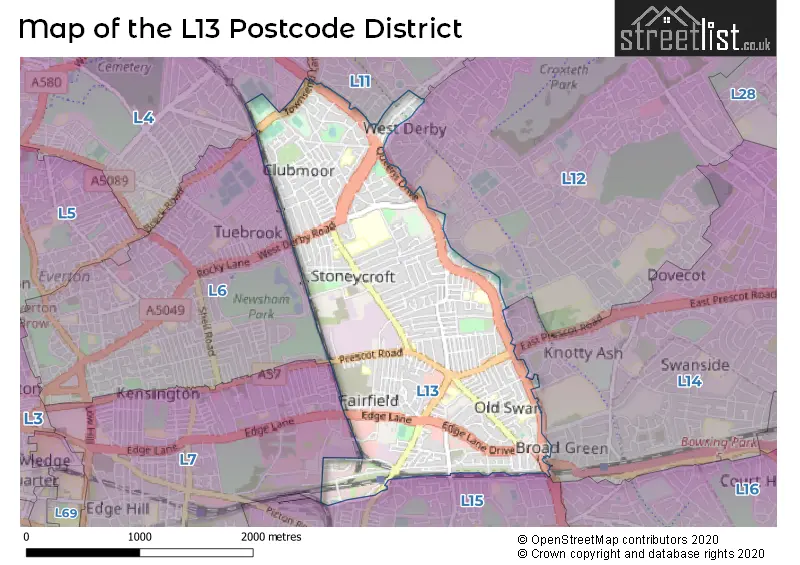
The L13 Postcode shares a border with L11 (LIVERPOOL, Norris Green, West Derby), L12 (LIVERPOOL, West Derby), L4 (LIVERPOOL, Walton, Anfield), L15 (LIVERPOOL, Wavertree), L7 (LIVERPOOL, Fairfield, Kensington) and L14 (LIVERPOOL, Knotty Ash, Broadgreen).
In the L13 postcode district, the primary settlement is Liverpool, located in the county of Merseyside in England. The most significant postal town in this district is Liverpool. Other significant settlements in this district include Old Swan, Stoneycroft, West Derby, Liverpool Shopping Park, Wavertree, Stanley, Tuebrook, and Clubmoor.
For the district L13, we have data on 10 postcode sectors. Here's a breakdown: The sector L13 0, covers Liverpool and West Derby in Merseyside. The sector L13 1, covers Liverpool and Wavertree and Old Swan in Merseyside. The sector L13 2, covers Liverpool in Merseyside. The sector L13 3, covers Liverpool and Old Swan in Merseyside. The sector L13 4, covers Liverpool and Old Swan in Merseyside. The sector L13 5, covers Liverpool and Old Swan in Merseyside. The sector L13 6, covers Liverpool in Merseyside. The sector L13 7, covers Liverpool and Stoneycroft in Merseyside. The sector L13 8, covers Liverpool and Tuebrook in Merseyside. The sector L13 9, covers Liverpool and Clubmoor in Merseyside.

Map of the L13 Postcode District
Explore the L13 postcode district by using our free interactive map.
When it comes to local government, postal geography often disregards political borders. However, for a breakdown in the L13 District: the district mostly encompasses the Liverpool District (B) area with a total of 560 postcodes.
Recent House Sales in L13
| Date | Price | Address |
|---|---|---|
| 20/10/2023 | £139,950 | Leinster Road, Liverpool, L13 5SX |
| 18/10/2023 | £127,500 | Craigs Road, Liverpool, L13 9AT |
| 17/10/2023 | £108,500 | Coral Street, Liverpool, L13 1DT |
| 06/10/2023 | £200,000 | Railbrook Hey, Old Swan, Liverpool, L13 1DL |
| 02/10/2023 | £70,000 | Baden Road, Liverpool, L13 5UN |
| 25/09/2023 | £197,500 | Guernsey Road, Liverpool, L13 6RY |
| 21/09/2023 | £25,000 | Buckingham Road, Tuebrook, Liverpool, L13 8AY |
| 13/09/2023 | £101,000 | Acanthus Road, Liverpool, L13 3DX |
| 13/09/2023 | £109,000 | Binns Road, Liverpool, L13 1BS |
| 01/09/2023 | £132,000 | Queens Drive, Stoneycroft, Liverpool, L13 5UB |
Weather Forecast for L13
Press Button to Show Forecast for West Derby
| Time Period | Icon | Description | Temperature | Rain Probability | Wind |
|---|---|---|---|---|---|
| 18:00 to 21:00 | Light rain shower (day) | 8.0°C (feels like 5.0°C) | 34.00% | NNW 13 mph | |
| 21:00 to 00:00 | Clear night | 7.0°C (feels like 5.0°C) | 2.00% | NNE 7 mph |
Press Button to Show Forecast for West Derby
| Time Period | Icon | Description | Temperature | Rain Probability | Wind |
|---|---|---|---|---|---|
| 00:00 to 03:00 | Clear night | 5.0°C (feels like 4.0°C) | 0.00% | NNE 4 mph | |
| 03:00 to 06:00 | Clear night | 4.0°C (feels like 2.0°C) | 0.00% | W 2 mph | |
| 06:00 to 09:00 | Sunny day | 4.0°C (feels like 3.0°C) | 0.00% | SSW 4 mph | |
| 09:00 to 12:00 | Cloudy | 8.0°C (feels like 6.0°C) | 5.00% | SW 7 mph | |
| 12:00 to 15:00 | Cloudy | 10.0°C (feels like 7.0°C) | 18.00% | W 13 mph | |
| 15:00 to 18:00 | Light rain | 9.0°C (feels like 6.0°C) | 56.00% | W 13 mph | |
| 18:00 to 21:00 | Heavy rain | 10.0°C (feels like 7.0°C) | 88.00% | WSW 13 mph | |
| 21:00 to 00:00 | Light rain | 10.0°C (feels like 7.0°C) | 53.00% | W 18 mph |
Press Button to Show Forecast for West Derby
| Time Period | Icon | Description | Temperature | Rain Probability | Wind |
|---|---|---|---|---|---|
| 00:00 to 03:00 | Overcast | 9.0°C (feels like 6.0°C) | 13.00% | WNW 18 mph | |
| 03:00 to 06:00 | Cloudy | 9.0°C (feels like 5.0°C) | 14.00% | WNW 18 mph | |
| 06:00 to 09:00 | Cloudy | 9.0°C (feels like 5.0°C) | 40.00% | NW 18 mph | |
| 09:00 to 12:00 | Partly cloudy (day) | 9.0°C (feels like 5.0°C) | 38.00% | NW 20 mph | |
| 12:00 to 15:00 | Partly cloudy (day) | 10.0°C (feels like 6.0°C) | 3.00% | NW 20 mph | |
| 15:00 to 18:00 | Sunny day | 11.0°C (feels like 7.0°C) | 1.00% | NW 20 mph | |
| 18:00 to 21:00 | Sunny day | 10.0°C (feels like 7.0°C) | 1.00% | NW 18 mph | |
| 21:00 to 00:00 | Partly cloudy (night) | 9.0°C (feels like 6.0°C) | 1.00% | NNW 11 mph |
Press Button to Show Forecast for West Derby
| Time Period | Icon | Description | Temperature | Rain Probability | Wind |
|---|---|---|---|---|---|
| 00:00 to 03:00 | Partly cloudy (night) | 7.0°C (feels like 5.0°C) | 2.00% | NNE 9 mph | |
| 03:00 to 06:00 | Partly cloudy (night) | 6.0°C (feels like 4.0°C) | 1.00% | NE 7 mph | |
| 06:00 to 09:00 | Sunny day | 5.0°C (feels like 4.0°C) | 1.00% | ENE 4 mph | |
| 09:00 to 12:00 | Sunny day | 8.0°C (feels like 6.0°C) | 1.00% | NNE 4 mph | |
| 12:00 to 15:00 | Sunny day | 10.0°C (feels like 8.0°C) | 1.00% | NNW 7 mph | |
| 15:00 to 18:00 | Partly cloudy (day) | 11.0°C (feels like 9.0°C) | 1.00% | NW 7 mph | |
| 18:00 to 21:00 | Sunny day | 10.0°C (feels like 9.0°C) | 1.00% | NW 7 mph | |
| 21:00 to 00:00 | Clear night | 9.0°C (feels like 7.0°C) | 0.00% | NNW 4 mph |
Press Button to Show Forecast for West Derby
| Time Period | Icon | Description | Temperature | Rain Probability | Wind |
|---|---|---|---|---|---|
| 00:00 to 03:00 | Clear night | 8.0°C (feels like 7.0°C) | 1.00% | N 4 mph | |
| 03:00 to 06:00 | Partly cloudy (night) | 7.0°C (feels like 6.0°C) | 2.00% | WSW 4 mph | |
| 06:00 to 09:00 | Cloudy | 7.0°C (feels like 6.0°C) | 4.00% | SSW 4 mph | |
| 09:00 to 12:00 | Cloudy | 10.0°C (feels like 9.0°C) | 5.00% | NW 4 mph | |
| 12:00 to 15:00 | Cloudy | 12.0°C (feels like 10.0°C) | 5.00% | NNW 7 mph | |
| 15:00 to 18:00 | Partly cloudy (day) | 13.0°C (feels like 11.0°C) | 8.00% | NE 9 mph | |
| 18:00 to 21:00 | Partly cloudy (day) | 13.0°C (feels like 11.0°C) | 1.00% | ENE 9 mph | |
| 21:00 to 00:00 | Cloudy | 11.0°C (feels like 9.0°C) | 4.00% | NNW 7 mph |
Where is the L13 Postcode District?
The data indicates that the postcode district L13 is located in Liverpool. Liverpool is surrounded by several nearby towns, including Bootle, Prescot, Wallasey, Birkenhead, and Ellesmere Port. Additionally, the distance between L13 and the center of London is approximately 177.09204853438766 miles.
The district is within the post town of LIVERPOOL.
The sector has postcodes within the nation of England.
The L13 Postcode District is in the Liverpool region of Merseyside within the North West (England).
Postcode Sectors within the L13 District
| Postcode Sector | Delivery Office |
|---|---|
| L13 0 | South Eastern (l) Delivery Office |
| L13 1 | South Eastern (l) Delivery Office |
| L13 2 | South Eastern (l) Delivery Office |
| L13 3 | South Eastern (l) Delivery Office |
| L13 4 | South Eastern (l) Delivery Office |
| L13 5 | South Eastern (l) Delivery Office |
| L13 6 | South Eastern (l) Delivery Office |
| L13 7 | South Eastern (l) Delivery Office |
| L13 8 | South Eastern (l) Delivery Office |
| L13 9 | South Eastern (l) Delivery Office |
| L | 1 | 3 | - | X | X | X |
| L | 1 | 3 | Space | Numeric | Letter | Letter |
Current Monthly Rental Prices
| # Bedrooms | Min Price | Max Price | Avg Price |
|---|---|---|---|
| £500 | £895 | £698 | |
| 1 | £398 | £800 | £581 |
| 2 | £699 | £2,500 | £977 |
| 3 | £750 | £900 | £828 |
| 4 | £950 | £2,167 | £1,559 |
| 5 | £542 | £542 | £542 |
| 6 | £2,400 | £2,400 | £2,400 |
| 8 | £351 | £351 | £351 |
Current House Prices
| # Bedrooms | Min Price | Max Price | Avg Price |
|---|---|---|---|
| £135,000 | £175,000 | £151,667 | |
| 1 | £27,000 | £110,000 | £81,355 |
| 2 | £50,000 | £199,950 | £115,365 |
| 3 | £70,000 | £230,000 | £150,532 |
| 4 | £120,000 | £425,000 | £224,750 |
| 5 | £230,000 | £230,000 | £230,000 |
| 6 | £300,000 | £300,000 | £300,000 |
| 7 | £330,000 | £350,000 | £340,000 |
Estate Agents who Operate in the L13 District
| Logo | Name | Brand Name | Address | Contact Number | Total Properties |
|---|---|---|---|---|---|
 | Old Swan | Entwistle Green | 11 Broadgreen Road, Liverpool, L13 5SD | 0151 453 4018 | 32 |
 | Liverpool | Acumen Estates | 40 East Prescot Road, Liverpool, L14 1PW | 0151 453 5452 | 11 |
 | Liverpool | Venmore | 8/10 Allerton Road, Mossley Hill, Liverpool, L18 1LN | 0151 453 6513 | 9 |
 | covering Liverpool | Purplebricks | Suite 7 First Floor Cranmore Drive Shirley Solihull B90 4RZ | 020 3907 2647 | 8 |
 | West Derby | Whitegates | 74 Mill Lane West Derby Liverpool L12 7JB | 0151 453 7273 | 8 |
| Type of Property | 2018 Average | 2018 Sales | 2017 Average | 2017 Sales | 2016 Average | 2016 Sales | 2015 Average | 2015 Sales |
|---|---|---|---|---|---|---|---|---|
| Detached | £150,417 | 6 | £193,929 | 7 | £176,800 | 5 | £133,758 | 12 |
| Semi-Detached | £133,662 | 94 | £127,895 | 79 | £121,774 | 99 | £118,407 | 76 |
| Terraced | £94,045 | 347 | £88,621 | 331 | £84,030 | 331 | £82,666 | 269 |
| Flats | £65,518 | 33 | £63,469 | 35 | £55,810 | 42 | £57,836 | 22 |
Hotels within the Postcode Area
We found 1 hotels and guest houses within the L13 postcode area