The L16 postcode district is a postal district located in the L Liverpool postcode area with a population of 14,672 residents according to the 2021 England and Wales Census.
The area of the L16 postcode district is 1.50 square miles which is 3.88 square kilometres or 957.69 acres.
Currently, the L16 district has about 243 postcode units spread across 10 geographic postcode sectors.
Given that each sector allows for 400 unique postcode combinations, the district has a capacity of 4,000 postcodes. With 243 postcodes already in use, this leaves 3757 units available.
The largest settlements in the L16 postal code are LIVERPOOL and Childwall.
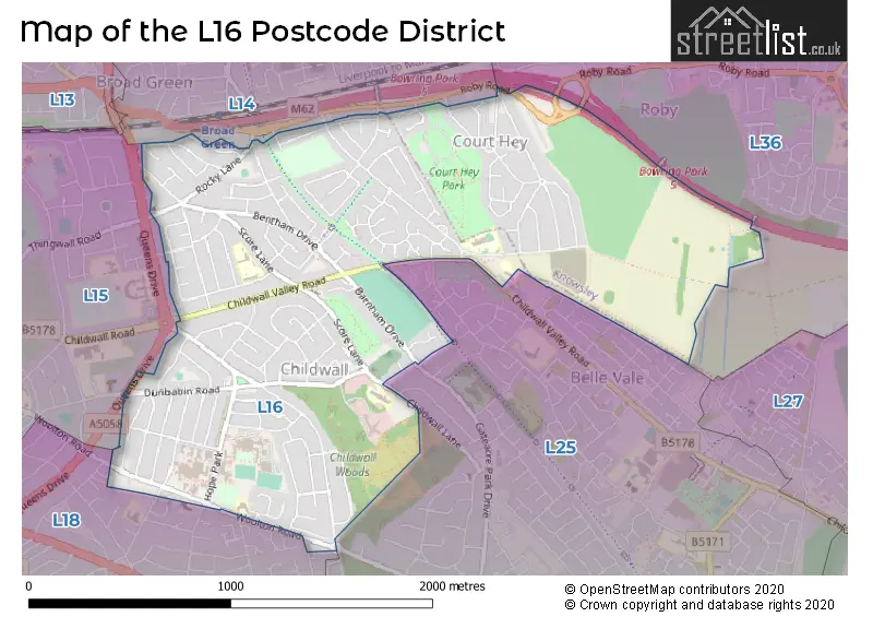
The L16 Postcode shares a border with L15 (LIVERPOOL, Wavertree), L18 (LIVERPOOL, Mossley Hill, Allerton), L14 (LIVERPOOL, Knotty Ash, Broadgreen), L25 (LIVERPOOL, Woolton, Hunts Cross) and L36 (LIVERPOOL, Huyton).
The primary settlement in the L16 postcode district is Liverpool, which is located in the county of Merseyside. Other significant settlements in the district include Childwall and Broadgreen. The most significant post town is Liverpool.
For the district L16, we have data on 10 postcode sectors. Here's a breakdown: The sector L16 0, covers Liverpool and Childwall in Merseyside. The sector L16 1, covers Liverpool and Childwall in Merseyside. The sector L16 2, covers Liverpool in Merseyside. The sector L16 3, covers Liverpool in Merseyside. The sector L16 4, covers Liverpool in Merseyside. The sector L16 5, covers Liverpool in Merseyside. The sector L16 6, covers Liverpool and Childwall in Merseyside. The sector L16 7, covers Liverpool in Merseyside. The sector L16 8, covers Liverpool and Childwall in Merseyside. The sector L16 9, covers Liverpool in Merseyside.

Map of the L16 Postcode District
Explore the L16 postcode district by using our free interactive map.
When it comes to local government, postal geography often disregards political borders. However, for a breakdown in the L16 District: the district mostly encompasses the Liverpool District (B) (214 postcodes), and finally, the Knowsley District (B) area (32 postcodes).
Recent House Sales in L16
| Date | Price | Address |
|---|---|---|
| 27/09/2023 | £632,500 | Childwall Park Avenue, Liverpool, L16 0JE |
| 11/09/2023 | £500,000 | Babbacombe Road, Liverpool, L16 9JN |
| 04/09/2023 | £1,000 | Thornton Road, Liverpool, L16 2LS |
| 31/08/2023 | £265,000 | Burford Road, Liverpool, L16 6AQ |
| 31/08/2023 | £265,000 | Keswick Villas, Huyton, Liverpool, L16 2NR |
| 25/08/2023 | £550,000 | Childwall Park Avenue, Liverpool, L16 0JF |
| 18/08/2023 | £258,000 | Christopher Close, Liverpool, L16 1JL |
| 18/08/2023 | £269,500 | Baldwin Avenue, Liverpool, L16 3GD |
| 18/08/2023 | £480,000 | Childwall Park Avenue, Liverpool, L16 0JH |
| 18/08/2023 | £350,000 | Score Lane, Liverpool, L16 5ED |
Weather Forecast for L16
Press Button to Show Forecast for Childwall
| Time Period | Icon | Description | Temperature | Rain Probability | Wind |
|---|---|---|---|---|---|
| 18:00 to 21:00 | Cloudy | 8.0°C (feels like 6.0°C) | 31.00% | NW 9 mph | |
| 21:00 to 00:00 | Cloudy | 7.0°C (feels like 5.0°C) | 5.00% | ENE 7 mph |
Press Button to Show Forecast for Childwall
| Time Period | Icon | Description | Temperature | Rain Probability | Wind |
|---|---|---|---|---|---|
| 00:00 to 03:00 | Cloudy | 6.0°C (feels like 3.0°C) | 5.00% | E 7 mph | |
| 03:00 to 06:00 | Clear night | 4.0°C (feels like 2.0°C) | 2.00% | E 7 mph | |
| 06:00 to 09:00 | Sunny day | 4.0°C (feels like 2.0°C) | 1.00% | E 4 mph | |
| 09:00 to 12:00 | Partly cloudy (day) | 7.0°C (feels like 5.0°C) | 1.00% | E 4 mph | |
| 12:00 to 15:00 | Cloudy | 9.0°C (feels like 8.0°C) | 6.00% | NE 4 mph | |
| 15:00 to 18:00 | Cloudy | 9.0°C (feels like 8.0°C) | 6.00% | N 4 mph | |
| 18:00 to 21:00 | Cloudy | 9.0°C (feels like 8.0°C) | 6.00% | NNE 7 mph | |
| 21:00 to 00:00 | Cloudy | 7.0°C (feels like 5.0°C) | 8.00% | NE 7 mph |
Press Button to Show Forecast for Childwall
| Time Period | Icon | Description | Temperature | Rain Probability | Wind |
|---|---|---|---|---|---|
| 00:00 to 03:00 | Partly cloudy (night) | 5.0°C (feels like 3.0°C) | 7.00% | ESE 7 mph | |
| 03:00 to 06:00 | Partly cloudy (night) | 4.0°C (feels like 2.0°C) | 7.00% | ESE 7 mph | |
| 06:00 to 09:00 | Partly cloudy (day) | 4.0°C (feels like 2.0°C) | 5.00% | E 7 mph | |
| 09:00 to 12:00 | Partly cloudy (day) | 8.0°C (feels like 6.0°C) | 5.00% | ESE 7 mph | |
| 12:00 to 15:00 | Overcast | 10.0°C (feels like 8.0°C) | 14.00% | E 7 mph | |
| 15:00 to 18:00 | Light rain | 10.0°C (feels like 9.0°C) | 46.00% | NE 7 mph | |
| 18:00 to 21:00 | Cloudy | 10.0°C (feels like 8.0°C) | 15.00% | ENE 9 mph | |
| 21:00 to 00:00 | Partly cloudy (night) | 8.0°C (feels like 6.0°C) | 13.00% | NE 9 mph |
Press Button to Show Forecast for Childwall
| Time Period | Icon | Description | Temperature | Rain Probability | Wind |
|---|---|---|---|---|---|
| 00:00 to 03:00 | Cloudy | 6.0°C (feels like 4.0°C) | 17.00% | NE 9 mph | |
| 03:00 to 06:00 | Cloudy | 6.0°C (feels like 3.0°C) | 16.00% | NNE 9 mph | |
| 06:00 to 09:00 | Light rain | 6.0°C (feels like 3.0°C) | 49.00% | NNE 11 mph | |
| 09:00 to 12:00 | Light rain | 8.0°C (feels like 5.0°C) | 49.00% | NNE 11 mph | |
| 12:00 to 15:00 | Light rain | 9.0°C (feels like 6.0°C) | 54.00% | N 11 mph | |
| 15:00 to 18:00 | Heavy rain | 10.0°C (feels like 7.0°C) | 71.00% | N 11 mph | |
| 18:00 to 21:00 | Partly cloudy (day) | 10.0°C (feels like 8.0°C) | 14.00% | NW 11 mph | |
| 21:00 to 00:00 | Clear night | 9.0°C (feels like 7.0°C) | 11.00% | WNW 9 mph |
Where is the L16 Postcode District?
The postcode district L16 is located in LIVERPOOL. It is situated east of PRESCOT, northwest of BOOTLE, west of BIRKENHEAD, northeast of ST. HELENS, and south of ELLESMERE PORT. L16 is approximately 174.94 miles away from the center of London.
The district is within the post town of LIVERPOOL.
The sector has postcodes within the nation of England.
The L16 Postcode District is covers the following regions.
- Liverpool - Merseyside - North West (England)
- East Merseyside - Merseyside - North West (England)
Postcode Sectors within the L16 District
| Postcode Sector | Delivery Office |
|---|---|
| L16 0 | South Eastern (l) Delivery Office |
| L16 1 | South Eastern (l) Delivery Office |
| L16 2 | South Eastern (l) Delivery Office |
| L16 3 | South Eastern (l) Delivery Office |
| L16 4 | South Eastern (l) Delivery Office |
| L16 5 | South Eastern (l) Delivery Office |
| L16 6 | South Eastern (l) Delivery Office |
| L16 7 | South Eastern (l) Delivery Office |
| L16 8 | South Eastern (l) Delivery Office |
| L16 9 | South Eastern (l) Delivery Office |
| L | 1 | 6 | - | X | X | X |
| L | 1 | 6 | Space | Numeric | Letter | Letter |
Current Monthly Rental Prices
| # Bedrooms | Min Price | Max Price | Avg Price |
|---|---|---|---|
| £450 | £525 | £490 | |
| 1 | £412 | £412 | £412 |
| 3 | £800 | £1,300 | £1,158 |
Current House Prices
| # Bedrooms | Min Price | Max Price | Avg Price |
|---|---|---|---|
| 2 | £180,000 | £275,000 | £227,500 |
| 3 | £165,000 | £400,000 | £281,624 |
| 4 | £250,000 | £590,000 | £416,373 |
| 5 | £290,000 | £490,000 | £390,000 |
| 6 | £550,000 | £550,000 | £550,000 |
Estate Agents who Operate in the L16 District
| Logo | Name | Brand Name | Address | Contact Number | Total Properties |
|---|---|---|---|---|---|
 | Allerton | Sutton Kersh | 38 Allerton Road Mossley Hill Liverpool L18 1LN | 0151 453 2272 | 12 |
 | Mossley Hill | Move Residential | 52/54 Allerton Road, Mossley Hill, Liverpool, L18 1LN | 0151 453 1497 | 10 |
 | covering Liverpool | Purplebricks | Suite 7 First Floor Cranmore Drive Shirley Solihull B90 4RZ | 020 3907 2647 | 9 |
 | Liverpool | Find Your Eden Limited | Liverpool | 0151 312 8288 | 8 |
 | Liverpool | Atlas Estate Agents | 2 Allerton Road Mossley Hill Liverpool L18 1LN | 0151 453 6186 | 5 |
| Type of Property | 2018 Average | 2018 Sales | 2017 Average | 2017 Sales | 2016 Average | 2016 Sales | 2015 Average | 2015 Sales |
|---|---|---|---|---|---|---|---|---|
| Detached | £313,944 | 18 | £330,914 | 29 | £263,856 | 18 | £273,952 | 27 |
| Semi-Detached | £232,433 | 146 | £220,720 | 155 | £219,919 | 118 | £202,446 | 143 |
| Terraced | £192,478 | 23 | £181,591 | 22 | £177,845 | 10 | £154,753 | 23 |
| Flats | £111,667 | 6 | £126,500 | 8 | £102,500 | 5 | £108,333 | 6 |