The L17 postcode district is a postal district located in the L Liverpool postcode area with a population of 22,910 residents according to the 2021 England and Wales Census.
The area of the L17 postcode district is 2.27 square miles which is 5.87 square kilometres or 1,451.51 acres.
Currently, the L17 district has about 454 postcode units spread across 10 geographic postcode sectors.
Given that each sector allows for 400 unique postcode combinations, the district has a capacity of 4,000 postcodes. With 454 postcodes already in use, this leaves 3546 units available.
The largest settlement in the L17 postal code is LIVERPOOL followed by Aigburth, and Sefton Park.
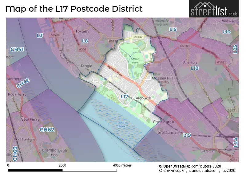
The postcode area has a boundary with Mersey.
The L17 Postcode shares a border with L19 (LIVERPOOL, Garston, Cressington), L15 (LIVERPOOL, Wavertree), L18 (LIVERPOOL, Mossley Hill, Allerton) and L8 (LIVERPOOL, Toxteth, Princes Park).
In the L17 postcode district in Liverpool, the primary settlement is Aigburth, which has the highest count. Other significant settlements in this district include Sefton Park. The L17 postcode district is part of the post town of Liverpool in the county of Merseyside, England.
For the district L17, we have data on 10 postcode sectors. Here's a breakdown: The sector L17 0, covers Liverpool and Aigburth in Merseyside. The sector L17 1, covers Liverpool and Sefton Park in Merseyside. The sector L17 2, covers Liverpool and Sefton Park in Merseyside. The sector L17 3, covers Liverpool and Sefton Park in Merseyside. The sector L17 4, covers Liverpool in Merseyside. The sector L17 5, covers Liverpool in Merseyside. The sector L17 6, covers Liverpool and Aigburth in Merseyside. The sector L17 7, covers Liverpool and Aigburth in Merseyside. The sector L17 8, covers Liverpool and Aigburth in Merseyside. The sector L17 9, covers Liverpool in Merseyside.


Map of the L17 Postcode District
Explore the L17 postcode district by using our free interactive map.
When it comes to local government, postal geography often disregards political borders. However, for a breakdown in the L17 District: the district mostly encompasses the Liverpool District (B) area with a total of 455 postcodes.
Recent House Sales in L17
| Date | Price | Address |
|---|---|---|
| 29/09/2023 | £186,000 | Birchtree Road, Liverpool, L17 0DS |
| 29/09/2023 | £400,000 | Ashfield Road, Liverpool, L17 0BZ |
| 29/09/2023 | £515,000 | Gresford Avenue, Wavertree, Liverpool, L17 2AN |
| 28/09/2023 | £220,547 | Belgrave Road, Aigburth, Liverpool, L17 7AH |
| 21/09/2023 | £365,000 | Fulwood Road, Liverpool, L17 9QA |
| 19/09/2023 | £316,100 | Belgrave Road, Aigburth, Liverpool, L17 7AQ |
| 15/09/2023 | £205,000 | Aigburth Vale, Liverpool, L17 0HG |
| 08/09/2023 | £575,000 | Ibbotsons Lane, Liverpool, L17 1AL |
| 08/09/2023 | £175,000 | Aigburth Vale, Liverpool, L17 0DG |
| 08/09/2023 | £333,500 | Ibbotsons Lane, Liverpool, L17 1AL |
Weather Forecast for L17
Press Button to Show Forecast for Liverpool Youth Hostel
| Time Period | Icon | Description | Temperature | Rain Probability | Wind |
|---|---|---|---|---|---|
| 12:00 to 15:00 | Cloudy | 10.0°C (feels like 7.0°C) | 6.00% | NW 11 mph | |
| 15:00 to 18:00 | Cloudy | 9.0°C (feels like 7.0°C) | 12.00% | NNW 9 mph | |
| 18:00 to 21:00 | Light rain | 8.0°C (feels like 6.0°C) | 43.00% | NNE 7 mph | |
| 21:00 to 00:00 | Cloudy | 7.0°C (feels like 5.0°C) | 4.00% | ENE 7 mph |
Press Button to Show Forecast for Liverpool Youth Hostel
| Time Period | Icon | Description | Temperature | Rain Probability | Wind |
|---|---|---|---|---|---|
| 00:00 to 03:00 | Cloudy | 6.0°C (feels like 4.0°C) | 4.00% | ESE 7 mph | |
| 03:00 to 06:00 | Clear night | 5.0°C (feels like 2.0°C) | 2.00% | E 7 mph | |
| 06:00 to 09:00 | Sunny day | 4.0°C (feels like 2.0°C) | 1.00% | E 7 mph | |
| 09:00 to 12:00 | Partly cloudy (day) | 7.0°C (feels like 6.0°C) | 1.00% | E 4 mph | |
| 12:00 to 15:00 | Cloudy | 9.0°C (feels like 8.0°C) | 6.00% | NNE 4 mph | |
| 15:00 to 18:00 | Cloudy | 10.0°C (feels like 8.0°C) | 6.00% | N 7 mph | |
| 18:00 to 21:00 | Cloudy | 9.0°C (feels like 8.0°C) | 6.00% | NNE 7 mph | |
| 21:00 to 00:00 | Cloudy | 7.0°C (feels like 5.0°C) | 8.00% | NE 9 mph |
Press Button to Show Forecast for Liverpool Youth Hostel
| Time Period | Icon | Description | Temperature | Rain Probability | Wind |
|---|---|---|---|---|---|
| 00:00 to 03:00 | Partly cloudy (night) | 6.0°C (feels like 3.0°C) | 6.00% | ESE 9 mph | |
| 03:00 to 06:00 | Partly cloudy (night) | 5.0°C (feels like 2.0°C) | 6.00% | ESE 7 mph | |
| 06:00 to 09:00 | Partly cloudy (day) | 5.0°C (feels like 2.0°C) | 5.00% | E 7 mph | |
| 09:00 to 12:00 | Cloudy | 8.0°C (feels like 6.0°C) | 8.00% | ESE 7 mph | |
| 12:00 to 15:00 | Overcast | 10.0°C (feels like 9.0°C) | 14.00% | E 7 mph | |
| 15:00 to 18:00 | Cloudy | 11.0°C (feels like 9.0°C) | 18.00% | NE 7 mph | |
| 18:00 to 21:00 | Cloudy | 10.0°C (feels like 8.0°C) | 15.00% | ENE 9 mph | |
| 21:00 to 00:00 | Partly cloudy (night) | 9.0°C (feels like 6.0°C) | 13.00% | ENE 9 mph |
Press Button to Show Forecast for Liverpool Youth Hostel
| Time Period | Icon | Description | Temperature | Rain Probability | Wind |
|---|---|---|---|---|---|
| 00:00 to 03:00 | Cloudy | 7.0°C (feels like 4.0°C) | 17.00% | NE 9 mph | |
| 03:00 to 06:00 | Cloudy | 6.0°C (feels like 3.0°C) | 16.00% | NNE 11 mph | |
| 06:00 to 09:00 | Light rain | 7.0°C (feels like 4.0°C) | 47.00% | NNE 11 mph | |
| 09:00 to 12:00 | Light rain | 8.0°C (feels like 6.0°C) | 49.00% | NNE 11 mph | |
| 12:00 to 15:00 | Light rain | 9.0°C (feels like 7.0°C) | 54.00% | NNE 11 mph | |
| 15:00 to 18:00 | Heavy rain | 10.0°C (feels like 8.0°C) | 71.00% | N 11 mph | |
| 18:00 to 21:00 | Partly cloudy (day) | 10.0°C (feels like 8.0°C) | 13.00% | WNW 13 mph | |
| 21:00 to 00:00 | Clear night | 9.0°C (feels like 7.0°C) | 11.00% | WNW 11 mph |
Where is the L17 Postcode District?
The postcode district L17 is located in Liverpool. It is nearby towns such as Birkenhead, Wallasey, Bootle, Ellesmere Port, Prescot, Neston, and Widnes. It is approximately 175.5 miles away from the centre of London.
The district is within the post town of LIVERPOOL.
The sector has postcodes within the nation of England.
The L17 Postcode District is in the Liverpool region of Merseyside within the North West (England).
Postcode Sectors within the L17 District
| Postcode Sector | Delivery Office |
|---|---|
| L17 0 | Lark Lane Delivery Office |
| L17 1 | Lark Lane Delivery Office |
| L17 2 | Lark Lane Delivery Office |
| L17 3 | Lark Lane Delivery Office |
| L17 4 | Lark Lane Delivery Office |
| L17 5 | Lark Lane Delivery Office |
| L17 6 | Lark Lane Delivery Office |
| L17 7 | Lark Lane Delivery Office |
| L17 8 | Lark Lane Delivery Office |
| L17 9 | Lark Lane Delivery Office |
| L | 1 | 7 | - | X | X | X |
| L | 1 | 7 | Space | Numeric | Letter | Letter |
Current Monthly Rental Prices
| # Bedrooms | Min Price | Max Price | Avg Price |
|---|---|---|---|
| £525 | £650 | £588 | |
| 1 | £320 | £850 | £506 |
| 2 | £725 | £1,750 | £1,140 |
| 3 | £520 | £2,395 | £1,258 |
| 4 | £410 | £1,750 | £1,310 |
| 5 | £90 | £1,625 | £595 |
| 6 | £394 | £2,550 | £792 |
| 7 | £346 | £2,975 | £826 |
| 8 | £282 | £282 | £282 |
Current House Prices
| # Bedrooms | Min Price | Max Price | Avg Price |
|---|---|---|---|
| £53,500 | £110,000 | £75,500 | |
| 1 | £34,250 | £210,000 | £119,881 |
| 2 | £77,600 | £425,000 | £210,100 |
| 3 | £150,000 | £425,000 | £275,572 |
| 4 | £230,000 | £1,200,000 | £511,471 |
| 5 | £375,000 | £1,150,000 | £682,389 |
| 6 | £400,000 | £550,000 | £483,333 |
| 9 | £725,000 | £725,000 | £725,000 |
Estate Agents who Operate in the L17 District
| Logo | Name | Brand Name | Address | Contact Number | Total Properties |
|---|---|---|---|---|---|
 | Mossley Hill | Move Residential | 52/54 Allerton Road, Mossley Hill, Liverpool, L18 1LN | 0151 453 1497 | 22 |
 | Liverpool | Find Your Eden Limited | Liverpool | 0151 312 8288 | 17 |
 | Liverpool | Venmore | 8/10 Allerton Road, Mossley Hill, Liverpool, L18 1LN | 0151 453 6513 | 15 |
 | covering Liverpool | Purplebricks | Suite 7 First Floor Cranmore Drive Shirley Solihull B90 4RZ | 020 3907 2647 | 12 |
 | Liverpool | Rooms4u | 467a Smithdown Road, Wavertree, Liverpool, L15 5AE | 0151 453 8343 | 11 |
| Type of Property | 2018 Average | 2018 Sales | 2017 Average | 2017 Sales | 2016 Average | 2016 Sales | 2015 Average | 2015 Sales |
|---|---|---|---|---|---|---|---|---|
| Detached | £378,721 | 47 | £359,684 | 30 | £384,370 | 33 | £349,048 | 47 |
| Semi-Detached | £253,669 | 50 | £259,908 | 76 | £251,948 | 61 | £274,168 | 46 |
| Terraced | £197,399 | 195 | £179,949 | 193 | £171,861 | 185 | £161,898 | 214 |
| Flats | £159,214 | 157 | £149,740 | 165 | £171,357 | 183 | £147,884 | 163 |