The L19 9 postcode sector is within the county of Merseyside.
Did you know? According to the 2021 Census, the L19 9 postcode sector is home to a bustling 3,341 residents!
Given that each sector allows for 400 unique postcode combinations. Letters C, I, K, M, O and V are not allowed in the last two letters of a postcode. With 71 postcodes already in use, this leaves 329 units available.
The largest settlements in the L19 9 postal code are LIVERPOOL and Garston.
The L19 9 Postcode shares a border with L19 7 (LIVERPOOL, Garston), L18 4 (LIVERPOOL), L19 0 (LIVERPOOL, Garston, Cressington), L19 1 (LIVERPOOL, Garston) and L19 3 (LIVERPOOL, Aigburth).
The sector is within the post town of LIVERPOOL.
L19 9 is a postcode sector within the L19 postcode district which is within the L Liverpool postcode area.
The Royal Mail delivery office for the L19 9 postal sector is the Garston Delivery Office.
The area of the L19 9 postcode sector is 0.22 square miles which is 0.56 square kilometres or 138.69 square acres.

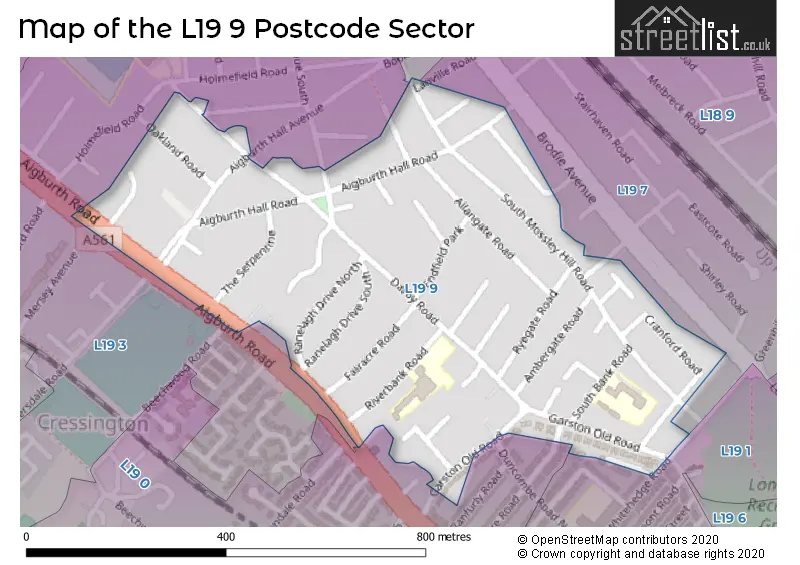
Map of the L19 9 Postcode Sector
Explore the L19 9 postcode sector by using our free interactive map.
| L | 1 | 9 | - | 9 | X | X |
| L | 1 | 9 | Space | 9 | Letter | Letter |
Official List of Streets
LIVERPOOL (38 Streets)
Garston (2 Streets)
Unofficial Streets or Alternative Spellings
LIVERPOOL
COOPER AVENUE SOUTH DUNCOMBE ROAD NORTH HALFPENNY CLOSE HOLMEFIELD AVENUE LANVILLE ROAD TORRINGTON ROADAigburth
MERSEY AVENUE RIVERSDALE ROADCressington
BEECHWOOD ROAD SOUTH BANK ROADWeather Forecast for L19 9
Press Button to Show Forecast for Grassendale
| Time Period | Icon | Description | Temperature | Rain Probability | Wind |
|---|---|---|---|---|---|
| 00:00 to 03:00 | Cloudy | 7.0°C (feels like 4.0°C) | 7.00% | W 7 mph | |
| 03:00 to 06:00 | Light rain | 7.0°C (feels like 5.0°C) | 46.00% | WNW 7 mph | |
| 06:00 to 09:00 | Cloudy | 7.0°C (feels like 4.0°C) | 10.00% | WNW 9 mph | |
| 09:00 to 12:00 | Cloudy | 8.0°C (feels like 5.0°C) | 11.00% | NW 11 mph | |
| 12:00 to 15:00 | Cloudy | 10.0°C (feels like 7.0°C) | 8.00% | NW 9 mph | |
| 15:00 to 18:00 | Cloudy | 9.0°C (feels like 8.0°C) | 35.00% | NNE 7 mph | |
| 18:00 to 21:00 | Cloudy | 8.0°C (feels like 6.0°C) | 31.00% | N 7 mph | |
| 21:00 to 00:00 | Cloudy | 7.0°C (feels like 5.0°C) | 5.00% | NE 7 mph |
Press Button to Show Forecast for Grassendale
| Time Period | Icon | Description | Temperature | Rain Probability | Wind |
|---|---|---|---|---|---|
| 00:00 to 03:00 | Partly cloudy (night) | 5.0°C (feels like 3.0°C) | 2.00% | E 7 mph | |
| 03:00 to 06:00 | Clear night | 4.0°C (feels like 2.0°C) | 2.00% | E 7 mph | |
| 06:00 to 09:00 | Sunny day | 4.0°C (feels like 1.0°C) | 1.00% | E 7 mph | |
| 09:00 to 12:00 | Cloudy | 7.0°C (feels like 5.0°C) | 4.00% | E 4 mph | |
| 12:00 to 15:00 | Overcast | 9.0°C (feels like 8.0°C) | 9.00% | E 4 mph | |
| 15:00 to 18:00 | Cloudy | 10.0°C (feels like 9.0°C) | 8.00% | E 4 mph | |
| 18:00 to 21:00 | Cloudy | 9.0°C (feels like 8.0°C) | 6.00% | NNE 4 mph | |
| 21:00 to 00:00 | Cloudy | 6.0°C (feels like 4.0°C) | 8.00% | NE 7 mph |
Press Button to Show Forecast for Grassendale
| Time Period | Icon | Description | Temperature | Rain Probability | Wind |
|---|---|---|---|---|---|
| 00:00 to 03:00 | Partly cloudy (night) | 5.0°C (feels like 2.0°C) | 7.00% | E 7 mph | |
| 03:00 to 06:00 | Partly cloudy (night) | 3.0°C (feels like 1.0°C) | 6.00% | E 7 mph | |
| 06:00 to 09:00 | Partly cloudy (day) | 4.0°C (feels like 2.0°C) | 5.00% | E 7 mph | |
| 09:00 to 12:00 | Partly cloudy (day) | 8.0°C (feels like 6.0°C) | 5.00% | ESE 7 mph | |
| 12:00 to 15:00 | Overcast | 10.0°C (feels like 8.0°C) | 14.00% | E 7 mph | |
| 15:00 to 18:00 | Light rain | 11.0°C (feels like 9.0°C) | 46.00% | ENE 9 mph | |
| 18:00 to 21:00 | Cloudy | 10.0°C (feels like 8.0°C) | 15.00% | ENE 9 mph | |
| 21:00 to 00:00 | Partly cloudy (night) | 8.0°C (feels like 5.0°C) | 12.00% | ENE 9 mph |
Press Button to Show Forecast for Grassendale
| Time Period | Icon | Description | Temperature | Rain Probability | Wind |
|---|---|---|---|---|---|
| 00:00 to 03:00 | Cloudy | 6.0°C (feels like 3.0°C) | 17.00% | NE 9 mph | |
| 03:00 to 06:00 | Cloudy | 6.0°C (feels like 3.0°C) | 16.00% | NNE 9 mph | |
| 06:00 to 09:00 | Light rain | 6.0°C (feels like 3.0°C) | 49.00% | NNE 9 mph | |
| 09:00 to 12:00 | Light rain | 8.0°C (feels like 5.0°C) | 51.00% | N 9 mph | |
| 12:00 to 15:00 | Light rain | 9.0°C (feels like 6.0°C) | 54.00% | N 11 mph | |
| 15:00 to 18:00 | Light rain | 10.0°C (feels like 7.0°C) | 53.00% | N 11 mph | |
| 18:00 to 21:00 | Partly cloudy (day) | 10.0°C (feels like 8.0°C) | 13.00% | NW 11 mph | |
| 21:00 to 00:00 | Clear night | 8.0°C (feels like 5.0°C) | 11.00% | W 9 mph |
Schools and Places of Education Within the L19 9 Postcode Sector
St Austin's Catholic Primary School
Voluntary aided school
Riverbank Road, Liverpool, Merseyside, L19 9DH
Head: Mrs Colette Hickey
Ofsted Rating: Good
Inspection: 2023-10-04 (204 days ago)
Website: Visit St Austin's Catholic Primary School Website
Phone: 01514271800
Number of Pupils: 432
House Prices in the L19 9 Postcode Sector
| Type of Property | 2018 Average | 2018 Sales | 2017 Average | 2017 Sales | 2016 Average | 2016 Sales | 2015 Average | 2015 Sales |
|---|---|---|---|---|---|---|---|---|
| Detached | £433,464 | 7 | £441,600 | 5 | £433,000 | 5 | £483,750 | 4 |
| Semi-Detached | £316,221 | 26 | £284,563 | 35 | £264,469 | 24 | £248,197 | 27 |
| Terraced | £170,333 | 6 | £192,190 | 5 | £210,907 | 15 | £176,200 | 5 |
| Flats | £137,590 | 5 | £40,000 | 2 | £146,849 | 15 | £121,938 | 4 |
Important Postcodes L19 9 in the Postcode Sector
L19 9AR is the postcode for Gilmour Infant School, Southbank Road, and GILMOUR INFANT SCHOOL, SOUTHBANK ROAD, LIVERPOOL
L19 9DH is the postcode for St. Austins Catholic Primary School, Riverbank Road
| The L19 9 Sector is within these Local Authorities |
|
|---|---|
| The L19 9 Sector is within these Counties |
|
| The L19 9 Sector is within these Water Company Areas |
|