The L2 postcode district is a postal district located in the L Liverpool postcode area with a population of 1,854 residents according to the 2021 England and Wales Census.
The area of the L2 postcode district is 0.12 square miles which is 0.32 square kilometres or 79.38 acres.
Currently, the L2 district has about 176 postcode units spread across 103 geographic postcode sectors.
Given that each sector allows for 400 unique postcode combinations, the district has a capacity of 41,200 postcodes. With 176 postcodes already in use, this leaves 41024 units available.
The L2 postal code covers the settlement of LIVERPOOL.
The postcode area has a boundary with Mersey.
The L2 Postcode shares a border with L3 (LIVERPOOL, Brunswick Business Park) and L1 (LIVERPOOL).
The primary settlement in the L2 postcode district is Liverpool in Merseyside, England. It has the highest count of 38. There are other significant settlements within the district, including Liverpool with counts ranging from 6 to 22. The post town for the L2 postcode district is also Liverpool in Merseyside, England.
For the district L2, we have data on 10 postcode sectors. Here's a breakdown: The sector L2 0, covers Liverpool in Merseyside. The sector L2 1, covers Liverpool in Merseyside. The sector L2 2, covers Liverpool in Merseyside. The sector L2 3, covers Liverpool in Merseyside. The sector L2 4, covers Liverpool in Merseyside. The sector L2 5, covers Liverpool in Merseyside. The sector L2 6, covers Liverpool in Merseyside. The sector L2 7, covers Liverpool in Merseyside. The sector L2 8, covers Liverpool in Merseyside. The sector L2 9, covers Liverpool in Merseyside.
L2 Postcode Sectors


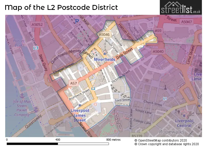
Map of the L2 Postcode District
Explore the L2 postcode district by using our free interactive map.
When it comes to local government, postal geography often disregards political borders. However, for a breakdown in the L2 District: the district mostly encompasses the Liverpool District (B) area with a total of 172 postcodes.
Recent House Sales in L21
| Date | Price | Address |
|---|---|---|
| 16/10/2023 | £65,000 | Kirk Road, Liverpool, L21 8HX |
| 11/10/2023 | £160,000 | Beach Road, Liverpool, L21 2PN |
| 10/10/2023 | £125,000 | Field Lane, Litherland, Liverpool, L21 9QE |
| 04/10/2023 | £155,000 | Sterrix Lane, Liverpool, L21 0DA |
| 28/09/2023 | £120,000 | Trawden Way, Liverpool, L21 0HX |
| 15/09/2023 | £120,000 | Durham Road, Liverpool, L21 1EE |
| 11/09/2023 | £60,000 | School Lane, Litherland, Liverpool, L21 7LZ |
| 08/09/2023 | £130,000 | William Wall Road, Liverpool, L21 0DU |
| 01/09/2023 | £105,000 | Sefton Avenue, Liverpool, L21 6NH |
| 01/09/2023 | £143,000 | Moorhead Close, Litherland, Liverpool, L21 2NA |
Weather Forecast for L2
Press Button to Show Forecast for Liverpool
| Time Period | Icon | Description | Temperature | Rain Probability | Wind |
|---|---|---|---|---|---|
| 09:00 to 12:00 | Cloudy | 9.0°C (feels like 7.0°C) | 3.00% | N 7 mph | |
| 12:00 to 15:00 | Cloudy | 10.0°C (feels like 8.0°C) | 4.00% | NNW 9 mph | |
| 15:00 to 18:00 | Sunny day | 11.0°C (feels like 8.0°C) | 1.00% | NW 13 mph | |
| 18:00 to 21:00 | Partly cloudy (day) | 10.0°C (feels like 8.0°C) | 1.00% | NW 11 mph | |
| 21:00 to 00:00 | Cloudy | 9.0°C (feels like 7.0°C) | 5.00% | NNW 9 mph |
Press Button to Show Forecast for Liverpool
| Time Period | Icon | Description | Temperature | Rain Probability | Wind |
|---|---|---|---|---|---|
| 00:00 to 03:00 | Cloudy | 9.0°C (feels like 7.0°C) | 16.00% | NW 7 mph | |
| 03:00 to 06:00 | Overcast | 8.0°C (feels like 6.0°C) | 9.00% | NNE 7 mph | |
| 06:00 to 09:00 | Cloudy | 7.0°C (feels like 4.0°C) | 6.00% | NNE 9 mph | |
| 09:00 to 12:00 | Partly cloudy (day) | 8.0°C (feels like 6.0°C) | 5.00% | NNE 9 mph | |
| 12:00 to 15:00 | Cloudy | 9.0°C (feels like 6.0°C) | 6.00% | N 11 mph | |
| 15:00 to 18:00 | Cloudy | 9.0°C (feels like 7.0°C) | 6.00% | NNW 11 mph | |
| 18:00 to 21:00 | Cloudy | 9.0°C (feels like 7.0°C) | 6.00% | N 11 mph | |
| 21:00 to 00:00 | Clear night | 8.0°C (feels like 5.0°C) | 2.00% | N 9 mph |
Press Button to Show Forecast for Liverpool
| Time Period | Icon | Description | Temperature | Rain Probability | Wind |
|---|---|---|---|---|---|
| 00:00 to 03:00 | Partly cloudy (night) | 6.0°C (feels like 4.0°C) | 5.00% | NNE 7 mph | |
| 03:00 to 06:00 | Cloudy | 6.0°C (feels like 3.0°C) | 7.00% | NNE 9 mph | |
| 06:00 to 09:00 | Cloudy | 6.0°C (feels like 3.0°C) | 6.00% | NNE 9 mph | |
| 09:00 to 12:00 | Cloudy | 7.0°C (feels like 5.0°C) | 7.00% | NNE 7 mph | |
| 12:00 to 15:00 | Cloudy | 9.0°C (feels like 7.0°C) | 8.00% | NW 7 mph | |
| 15:00 to 18:00 | Cloudy | 9.0°C (feels like 7.0°C) | 8.00% | NNW 9 mph | |
| 18:00 to 21:00 | Cloudy | 9.0°C (feels like 7.0°C) | 8.00% | NNW 7 mph | |
| 21:00 to 00:00 | Cloudy | 8.0°C (feels like 7.0°C) | 9.00% | N 7 mph |
Press Button to Show Forecast for Liverpool
| Time Period | Icon | Description | Temperature | Rain Probability | Wind |
|---|---|---|---|---|---|
| 00:00 to 03:00 | Cloudy | 8.0°C (feels like 6.0°C) | 8.00% | SE 7 mph | |
| 03:00 to 06:00 | Overcast | 7.0°C (feels like 5.0°C) | 12.00% | E 7 mph | |
| 06:00 to 09:00 | Overcast | 7.0°C (feels like 5.0°C) | 11.00% | ENE 7 mph | |
| 09:00 to 12:00 | Cloudy | 8.0°C (feels like 6.0°C) | 10.00% | NNW 9 mph | |
| 12:00 to 15:00 | Cloudy | 10.0°C (feels like 8.0°C) | 12.00% | NNW 9 mph | |
| 15:00 to 18:00 | Cloudy | 10.0°C (feels like 8.0°C) | 17.00% | NNW 9 mph | |
| 18:00 to 21:00 | Cloudy | 10.0°C (feels like 8.0°C) | 11.00% | N 9 mph | |
| 21:00 to 00:00 | Cloudy | 9.0°C (feels like 7.0°C) | 12.00% | N 9 mph |
Where is the L2 Postcode District?
The data indicates that the "L2" postcode district is located in the town of Liverpool. This district is also in close proximity to several nearby towns. To the North West, there is Wallasey, which is approximately 2.69 miles away. To the South West, there is Birkenhead, which is around 3.14 miles away. Bootle is situated to the North and is approximately 4.15 miles away. To the South, Neston is located around 8.07 miles away. Prescot is to the East, about 8.14 miles away. Finally, to the South East, there is Ellesmere Port, which is approximately 9.31 miles away. Moreover, the postcode district L2 is around 178.43 miles away from the center of London.
The district is within the post town of LIVERPOOL.
The sector has postcodes within the nation of England.
The L2 Postcode District is in the Liverpool region of Merseyside within the North West (England).
Postcode Sectors within the L2 District
- L2 0
- L2 1
- L2 2
- L2 3
- L2 4
- L2 5
- L2 6
- L2 7
- L2 8
- L2 9
- L20 0
- L20 1
- L20 2
- L20 3
- L20 4
- L20 5
- L20 6
- L20 7
- L20 8
- L20 9
- L21 0
- L21 1
- L21 2
- L21 3
- L21 4
- L21 5
- L21 6
- L21 7
- L21 8
- L21 9
- L22 0
- L22 1
- L22 2
- L22 3
- L22 4
- L22 5
- L22 6
- L22 7
- L22 8
- L22 9
- L23 0
- L23 1
- L23 2
- L23 3
- L23 4
- L23 5
- L23 6
- L23 7
- L23 8
- L23 9
- L24 0
- L24 1
- L24 2
- L24 3
- L24 4
- L24 5
- L24 6
- L24 7
- L24 8
- L24 9
- L25 0
- L25 1
- L25 2
- L25 3
- L25 4
- L25 5
- L25 6
- L25 7
- L25 8
- L25 9
- L26 0
- L26 1
- L26 2
- L26 3
- L26 4
- L26 5
- L26 6
- L26 7
- L26 8
- L26 9
- L27 0
- L27 1
- L27 2
- L27 3
- L27 4
- L27 5
- L27 6
- L27 7
- L27 8
- L28 0
- L28 1
- L28 3
- L28 4
- L28 5
- L28 6
- L28 7
- L28 8
- L29 1
- L29 5
- L29 6
- L29 7
- L29 8
- L29 9
| Postcode Sector | Delivery Office |
|---|---|
| L2 0 | Liverpool 1-3 |
| L2 1 | Liverpool 1-3 |
| L2 2 | Liverpool 1-3 |
| L2 3 | Liverpool 1-3 |
| L2 4 | Liverpool 1-3 |
| L2 5 | Liverpool 1-3 |
| L2 6 | Liverpool 1-3 |
| L2 7 | Liverpool 1-3 |
| L2 8 | Liverpool 1-3 |
| L2 9 | Liverpool 1-3 |
| L | 2 | - | X | X | X |
| L | 2 | Space | Numeric | Letter | Letter |
Current Monthly Rental Prices
| # Bedrooms | Min Price | Max Price | Avg Price |
|---|---|---|---|
| £125 | £4,050 | £952 | |
| 1 | £390 | £1,440 | £806 |
| 2 | £850 | £1,750 | £1,223 |
| 5 | £498 | £607 | £553 |
Current House Prices
| # Bedrooms | Min Price | Max Price | Avg Price |
|---|---|---|---|
| £40,000 | £135,000 | £91,499 | |
| 1 | £30,000 | £190,000 | £125,151 |
| 2 | £85,000 | £350,000 | £196,013 |
Estate Agents who Operate in the L2 District
| Logo | Name | Brand Name | Address | Contact Number | Total Properties |
|---|---|---|---|---|---|
 | Liverpool | RW Invest | Unit 101, Tea Factory, 82 Wood Street, Liverpool, L1 4DQ | 0151 453 4672 | 25 |
 | Liverpool | Elite Realty Invest | Suite 222B 2nd Floor, Cotton Exchange Building, Bixteth Street Liverpool L3 9JR | 0151 453 2241 | 21 |
 | London | RW Invest | City Point 1 Ropemaker St London EC2Y 9AW | 020 3907 9852 | 18 |
 | Canary Wharf | Flambard Williams Limited | 30 Churchill Place, London, E14 5RE | 020 3640 9331 | 10 |
 | Liverpool | Ascend | Unit 1A, Old Haymarket, 73-89 Victoria Street Liverpool, L1 6DE | 0151 453 5621 | 10 |
| Type of Property | 2018 Average | 2018 Sales | 2017 Average | 2017 Sales | 2016 Average | 2016 Sales | 2015 Average | 2015 Sales |
|---|---|---|---|---|---|---|---|---|
| Detached | £1,260,000 | 1 | £0 | 0 | £0 | 0 | £0 | 0 |
| Semi-Detached | £130,500 | 2 | £0 | 0 | £0 | 0 | £0 | 0 |
| Terraced | £0 | 0 | £0 | 0 | £0 | 0 | £0 | 0 |
| Flats | £149,146 | 321 | £143,122 | 305 | £129,380 | 235 | £116,896 | 26 |