The L21 postcode district is a postal district located in the L Liverpool postcode area with a population of 24,954 residents according to the 2021 England and Wales Census.
The area of the L21 postcode district is 2.63 square miles which is 6.81 square kilometres or 1,681.94 acres.
Currently, the L21 district has about 562 postcode units spread across 10 geographic postcode sectors.
Given that each sector allows for 400 unique postcode combinations, the district has a capacity of 4,000 postcodes. With 562 postcodes already in use, this leaves 3438 units available.
The largest settlement in the L21 postal code is LIVERPOOL followed by Litherland, and Seaforth.
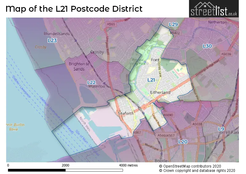
The postcode area has a boundary with Mersey and The Irish Sea.
The L21 Postcode shares a border with L20 (BOOTLE, LIVERPOOL, Kirkdale), L22 (Waterloo, LIVERPOOL, Brighton-le-Sands) and L23 (LIVERPOOL, Crosby, Thornton).
The primary settlement in the L21 postcode district is Liverpool, which is located in the county of Merseyside, England. It has the highest count of 55. Other significant settlements include Ford and Seaforth. The most significant post town in this postcode district is also Liverpool.
For the district L21, we have data on 10 postcode sectors. Here's a breakdown: The sector L21 0, covers Liverpool and Ford in Merseyside. The sector L21 1, covers Liverpool and Seaforth in Merseyside. The sector L21 2, covers Liverpool and Litherland in Merseyside. The sector L21 3, covers Liverpool and Seaforth in Merseyside. The sector L21 4, covers Liverpool and Seaforth in Merseyside. The sector L21 5, covers Liverpool and Litherland in Merseyside. The sector L21 6, covers Liverpool and Litherland in Merseyside. The sector L21 7, covers Liverpool and Litherland in Merseyside. The sector L21 8, covers Liverpool and Litherland in Merseyside. The sector L21 9, covers Liverpool and Litherland in Merseyside.

Map of the L21 Postcode District
Explore the L21 postcode district by using our free interactive map.
When it comes to local government, postal geography often disregards political borders. However, for a breakdown in the L21 District: the district mostly encompasses the Sefton District (B) area with a total of 570 postcodes.
Recent House Sales in L21
| Date | Price | Address |
|---|---|---|
| 16/10/2023 | £65,000 | Kirk Road, Liverpool, L21 8HX |
| 11/10/2023 | £160,000 | Beach Road, Liverpool, L21 2PN |
| 10/10/2023 | £125,000 | Field Lane, Litherland, Liverpool, L21 9QE |
| 04/10/2023 | £155,000 | Sterrix Lane, Liverpool, L21 0DA |
| 28/09/2023 | £120,000 | Trawden Way, Liverpool, L21 0HX |
| 15/09/2023 | £120,000 | Durham Road, Liverpool, L21 1EE |
| 11/09/2023 | £60,000 | School Lane, Litherland, Liverpool, L21 7LZ |
| 08/09/2023 | £130,000 | William Wall Road, Liverpool, L21 0DU |
| 01/09/2023 | £105,000 | Sefton Avenue, Liverpool, L21 6NH |
| 01/09/2023 | £143,000 | Moorhead Close, Litherland, Liverpool, L21 2NA |
Weather Forecast for L21
Press Button to Show Forecast for Litherland
| Time Period | Icon | Description | Temperature | Rain Probability | Wind |
|---|---|---|---|---|---|
| 00:00 to 03:00 | Partly cloudy (night) | 6.0°C (feels like 4.0°C) | 2.00% | E 7 mph | |
| 03:00 to 06:00 | Clear night | 4.0°C (feels like 2.0°C) | 2.00% | E 7 mph | |
| 06:00 to 09:00 | Sunny day | 4.0°C (feels like 2.0°C) | 2.00% | E 7 mph | |
| 09:00 to 12:00 | Partly cloudy (day) | 7.0°C (feels like 5.0°C) | 5.00% | ESE 4 mph | |
| 12:00 to 15:00 | Cloudy | 9.0°C (feels like 8.0°C) | 6.00% | N 4 mph | |
| 15:00 to 18:00 | Cloudy | 9.0°C (feels like 8.0°C) | 6.00% | N 7 mph | |
| 18:00 to 21:00 | Cloudy | 9.0°C (feels like 7.0°C) | 6.00% | NNE 7 mph | |
| 21:00 to 00:00 | Cloudy | 7.0°C (feels like 5.0°C) | 7.00% | NE 9 mph |
Press Button to Show Forecast for Litherland
| Time Period | Icon | Description | Temperature | Rain Probability | Wind |
|---|---|---|---|---|---|
| 00:00 to 03:00 | Partly cloudy (night) | 6.0°C (feels like 3.0°C) | 4.00% | ESE 9 mph | |
| 03:00 to 06:00 | Partly cloudy (night) | 4.0°C (feels like 2.0°C) | 6.00% | ESE 7 mph | |
| 06:00 to 09:00 | Partly cloudy (day) | 5.0°C (feels like 2.0°C) | 4.00% | E 7 mph | |
| 09:00 to 12:00 | Cloudy | 8.0°C (feels like 6.0°C) | 8.00% | ESE 7 mph | |
| 12:00 to 15:00 | Overcast | 10.0°C (feels like 9.0°C) | 12.00% | E 7 mph | |
| 15:00 to 18:00 | Overcast | 10.0°C (feels like 9.0°C) | 18.00% | NE 7 mph | |
| 18:00 to 21:00 | Cloudy | 10.0°C (feels like 8.0°C) | 14.00% | ENE 9 mph | |
| 21:00 to 00:00 | Cloudy | 8.0°C (feels like 6.0°C) | 13.00% | ENE 9 mph |
Press Button to Show Forecast for Litherland
| Time Period | Icon | Description | Temperature | Rain Probability | Wind |
|---|---|---|---|---|---|
| 00:00 to 03:00 | Light rain | 7.0°C (feels like 4.0°C) | 45.00% | NE 9 mph | |
| 03:00 to 06:00 | Cloudy | 6.0°C (feels like 3.0°C) | 15.00% | NNE 11 mph | |
| 06:00 to 09:00 | Light rain | 7.0°C (feels like 4.0°C) | 48.00% | NNE 11 mph | |
| 09:00 to 12:00 | Cloudy | 8.0°C (feels like 5.0°C) | 20.00% | NNE 11 mph | |
| 12:00 to 15:00 | Light rain | 9.0°C (feels like 6.0°C) | 50.00% | N 11 mph | |
| 15:00 to 18:00 | Heavy rain | 10.0°C (feels like 7.0°C) | 70.00% | NNW 11 mph | |
| 18:00 to 21:00 | Partly cloudy (day) | 10.0°C (feels like 7.0°C) | 14.00% | WNW 13 mph | |
| 21:00 to 00:00 | Partly cloudy (night) | 9.0°C (feels like 7.0°C) | 9.00% | WNW 11 mph |
Where is the L21 Postcode District?
The postcode district L21 is located in the town of Liverpool. It is in close proximity to the nearby towns of Bootle, Wallasey, Prenton, Ormskirk, and Prescot. Additionally, it is approximately 182.14 miles away from the center of London.
The district is within the post town of LIVERPOOL.
The sector has postcodes within the nation of England.
The L21 Postcode District is in the Sefton region of Merseyside within the North West (England).
Postcode Sectors within the L21 District
| Postcode Sector | Delivery Office |
|---|---|
| L21 0 | Seaforth Delivery Office |
| L21 1 | Seaforth Delivery Office |
| L21 2 | Seaforth Delivery Office |
| L21 3 | Seaforth Delivery Office |
| L21 4 | Seaforth Delivery Office |
| L21 5 | Seaforth Delivery Office |
| L21 6 | Seaforth Delivery Office |
| L21 7 | Seaforth Delivery Office |
| L21 8 | Seaforth Delivery Office |
| L21 9 | Seaforth Delivery Office |
| L | 2 | 1 | - | X | X | X |
| L | 2 | 1 | Space | Numeric | Letter | Letter |
Current Monthly Rental Prices
| # Bedrooms | Min Price | Max Price | Avg Price |
|---|---|---|---|
| £550 | £550 | £550 | |
| 1 | £450 | £450 | £450 |
| 2 | £625 | £800 | £700 |
| 3 | £550 | £875 | £783 |
| 4 | £2,299 | £2,299 | £2,299 |
Current House Prices
| # Bedrooms | Min Price | Max Price | Avg Price |
|---|---|---|---|
| £105,000 | £150,000 | £130,000 | |
| 1 | £60,000 | £60,000 | £60,000 |
| 2 | £55,000 | £165,000 | £98,739 |
| 3 | £25,000 | £350,000 | £170,616 |
| 4 | £110,000 | £280,000 | £185,385 |
| 5 | £100,000 | £430,000 | £265,000 |
| 8 | £700,000 | £700,000 | £700,000 |
| 16 | £1,100,000 | £1,100,000 | £1,100,000 |
Estate Agents who Operate in the L21 District
| Logo | Name | Brand Name | Address | Contact Number | Total Properties |
|---|---|---|---|---|---|
 | Sefton | Whitegates | 9 Harris Drive, Bootle, Liverpool, L20 6LD | 0151 453 3896 | 25 |
 | Liverpool | Lyons Estates Ltd | 50 Aintree Road, Liverpool, L20 9DN | 0151 453 3674 | 17 |
 | Crosby | Entwistle Green | 86 Coronation Road, Crosby, Liverpool, L23 5RH | 0151 453 7877 | 12 |
 | Liverpool | Logic | 97 South Road, Waterloo, Liverpool, L22 0LR | 0151 453 5490 | 8 |
 | Crosby | Abode | 82 Coronation Road, Crosby, Liverpool, L23 5RH | 0151 453 8369 | 8 |
| Type of Property | 2018 Average | 2018 Sales | 2017 Average | 2017 Sales | 2016 Average | 2016 Sales | 2015 Average | 2015 Sales |
|---|---|---|---|---|---|---|---|---|
| Detached | £189,708 | 12 | £243,719 | 16 | £177,753 | 9 | £199,637 | 21 |
| Semi-Detached | £144,433 | 89 | £139,462 | 116 | £125,017 | 98 | £133,734 | 125 |
| Terraced | £79,155 | 178 | £79,598 | 160 | £74,503 | 165 | £69,574 | 147 |
| Flats | £63,333 | 27 | £61,860 | 75 | £61,950 | 12 | £65,853 | 17 |