The L26 postcode district is a postal district located in the L Liverpool postcode area with a population of 15,321 residents according to the 2021 England and Wales Census.
The area of the L26 postcode district is 2.96 square miles which is 7.66 square kilometres or 1,892.04 acres.
Currently, the L26 district has about 323 postcode units spread across 10 geographic postcode sectors.
Given that each sector allows for 400 unique postcode combinations, the district has a capacity of 4,000 postcodes. With 323 postcodes already in use, this leaves 3677 units available.
The largest settlements in the L26 postal code are LIVERPOOL and Halewood.
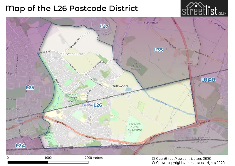
The L26 Postcode shares a border with L27 (LIVERPOOL, Netherley) and L35 (Rainhill, Whiston, PRESCOT).
The primary settlement in the L26 postcode district is Liverpool, located in the county of Merseyside in England. Other significant settlements include Halewood, also in Liverpool.
For the district L26, we have data on 10 postcode sectors. Here's a breakdown: The sector L26 0, covers Liverpool and Halewood in Merseyside. The sector L26 1, covers Liverpool and Halewood in Merseyside. The sector L26 2, covers Liverpool and Halewood in Merseyside. The sector L26 3, covers Liverpool and Halewood in Merseyside. The sector L26 4, covers Liverpool in Merseyside. The sector L26 5, covers Liverpool and Halewood in Merseyside. The sector L26 6, covers Halewood and Liverpool in Merseyside. The sector L26 7, covers Liverpool in Merseyside. The sector L26 8, covers Halewood in Merseyside. The sector L26 9, covers Liverpool and Halewood in Merseyside.


Map of the L26 Postcode District
Explore the L26 postcode district by using our free interactive map.
When it comes to local government, postal geography often disregards political borders. However, for a breakdown in the L26 District: the district mostly encompasses the Knowsley District (B) (341 postcodes), and finally, the Liverpool District (B) area (4 postcodes).
Recent House Sales in L26
| Date | Price | Address |
|---|---|---|
| 20/10/2023 | £245,000 | Abingdon Grove, Halewood, Liverpool, L26 6LS |
| 05/10/2023 | £330,000 | Higher Road, Liverpool, L26 9UE |
| 20/09/2023 | £240,000 | Heron Court, Liverpool, L26 7WX |
| 07/09/2023 | £185,000 | Ravenfield Close, Liverpool, L26 7AQ |
| 04/09/2023 | £280,000 | Crantock Close, Halewood, Liverpool, L26 0XG |
| 25/08/2023 | £295,000 | Fernwood Drive, Liverpool, L26 7ZB |
| 25/08/2023 | £158,000 | Rusholme Close, Liverpool, L26 9US |
| 23/08/2023 | £127,000 | Holland Road, Halewood, Liverpool, L26 1UE |
| 16/08/2023 | £1,200,000 | Lower Road, Liverpool, L26 3UB |
| 15/08/2023 | £174,995 | Aldersgate Drive, Liverpool, L26 9YB |
Weather Forecast for L26
Press Button to Show Forecast for Halewood
| Time Period | Icon | Description | Temperature | Rain Probability | Wind |
|---|---|---|---|---|---|
| 09:00 to 12:00 | Cloudy | 10.0°C (feels like 6.0°C) | 5.00% | NW 20 mph | |
| 12:00 to 15:00 | Partly cloudy (day) | 11.0°C (feels like 7.0°C) | 1.00% | NW 20 mph | |
| 15:00 to 18:00 | Cloudy | 11.0°C (feels like 8.0°C) | 5.00% | NNW 18 mph | |
| 18:00 to 21:00 | Partly cloudy (day) | 10.0°C (feels like 8.0°C) | 6.00% | NNW 13 mph | |
| 21:00 to 00:00 | Cloudy | 9.0°C (feels like 7.0°C) | 5.00% | NNW 7 mph |
Press Button to Show Forecast for Halewood
| Time Period | Icon | Description | Temperature | Rain Probability | Wind |
|---|---|---|---|---|---|
| 00:00 to 03:00 | Cloudy | 7.0°C (feels like 6.0°C) | 7.00% | NE 4 mph | |
| 03:00 to 06:00 | Cloudy | 6.0°C (feels like 5.0°C) | 4.00% | ENE 2 mph | |
| 06:00 to 09:00 | Cloudy | 6.0°C (feels like 5.0°C) | 4.00% | NE 2 mph | |
| 09:00 to 12:00 | Partly cloudy (day) | 8.0°C (feels like 7.0°C) | 2.00% | NE 4 mph | |
| 12:00 to 15:00 | Cloudy | 10.0°C (feels like 9.0°C) | 5.00% | N 7 mph | |
| 15:00 to 18:00 | Cloudy | 11.0°C (feels like 9.0°C) | 4.00% | NNW 7 mph | |
| 18:00 to 21:00 | Sunny day | 10.0°C (feels like 9.0°C) | 1.00% | NNW 7 mph | |
| 21:00 to 00:00 | Clear night | 8.0°C (feels like 7.0°C) | 1.00% | NNW 4 mph |
Press Button to Show Forecast for Halewood
| Time Period | Icon | Description | Temperature | Rain Probability | Wind |
|---|---|---|---|---|---|
| 00:00 to 03:00 | Partly cloudy (night) | 7.0°C (feels like 6.0°C) | 1.00% | NW 4 mph | |
| 03:00 to 06:00 | Partly cloudy (night) | 6.0°C (feels like 5.0°C) | 1.00% | NW 4 mph | |
| 06:00 to 09:00 | Cloudy | 7.0°C (feels like 6.0°C) | 3.00% | NW 4 mph | |
| 09:00 to 12:00 | Cloudy | 10.0°C (feels like 9.0°C) | 4.00% | NW 7 mph | |
| 12:00 to 15:00 | Cloudy | 12.0°C (feels like 10.0°C) | 4.00% | N 7 mph | |
| 15:00 to 18:00 | Cloudy | 12.0°C (feels like 11.0°C) | 9.00% | N 7 mph | |
| 18:00 to 21:00 | Light rain | 12.0°C (feels like 10.0°C) | 39.00% | NE 7 mph | |
| 21:00 to 00:00 | Partly cloudy (night) | 10.0°C (feels like 8.0°C) | 1.00% | NE 7 mph |
Press Button to Show Forecast for Halewood
| Time Period | Icon | Description | Temperature | Rain Probability | Wind |
|---|---|---|---|---|---|
| 00:00 to 03:00 | Partly cloudy (night) | 8.0°C (feels like 6.0°C) | 2.00% | ENE 7 mph | |
| 03:00 to 06:00 | Cloudy | 7.0°C (feels like 5.0°C) | 6.00% | ENE 7 mph | |
| 06:00 to 09:00 | Cloudy | 7.0°C (feels like 5.0°C) | 6.00% | ENE 7 mph | |
| 09:00 to 12:00 | Cloudy | 9.0°C (feels like 7.0°C) | 6.00% | ENE 7 mph | |
| 12:00 to 15:00 | Light rain | 10.0°C (feels like 8.0°C) | 37.00% | ENE 9 mph | |
| 15:00 to 18:00 | Cloudy | 11.0°C (feels like 9.0°C) | 15.00% | ENE 9 mph | |
| 18:00 to 21:00 | Overcast | 11.0°C (feels like 10.0°C) | 11.00% | NNE 7 mph | |
| 21:00 to 00:00 | Cloudy | 9.0°C (feels like 8.0°C) | 7.00% | ENE 7 mph |
Where is the L26 Postcode District?
The data shows that the postcode district L26 is located in LIVERPOOL. It is in close proximity to several nearby towns, including WIDNES to the East (distance: 3.31 miles), PRESCOT to the North (distance: 3.98 miles), RUNCORN to the South East (distance: 5.72 miles), ELLESMERE PORT to the South West (distance: 6.24 miles), ST. HELENS to the North East (distance: 7.51 miles), BIRKENHEAD to the West (distance: 9.20 miles), and BOOTLE to the North West (distance: 9.62 miles). Additionally, the distance from L26 to London's centre is 171.67 miles.
The district is within the post town of LIVERPOOL.
The sector has postcodes within the nation of England.
The L26 Postcode District is covers the following regions.
- East Merseyside - Merseyside - North West (England)
- Liverpool - Merseyside - North West (England)
Postcode Sectors within the L26 District
| Postcode Sector | Delivery Office |
|---|---|
| L26 0 | Woolton Delivery Office |
| L26 1 | Woolton Delivery Office |
| L26 2 | Woolton Delivery Office |
| L26 3 | Woolton Delivery Office |
| L26 4 | Woolton Delivery Office |
| L26 5 | Woolton Delivery Office |
| L26 6 | Woolton Delivery Office |
| L26 7 | Woolton Delivery Office |
| L26 8 | Woolton Delivery Office |
| L26 9 | Woolton Delivery Office |
| L | 2 | 6 | - | X | X | X |
| L | 2 | 6 | Space | Numeric | Letter | Letter |
Current Monthly Rental Prices
| # Bedrooms | Min Price | Max Price | Avg Price |
|---|---|---|---|
| 3 | £1,095 | £1,095 | £1,095 |
Current House Prices
| # Bedrooms | Min Price | Max Price | Avg Price |
|---|---|---|---|
| 1 | £45,000 | £110,000 | £77,500 |
| 2 | £67,350 | £325,000 | £126,939 |
| 3 | £95,000 | £475,000 | £251,706 |
| 4 | £200,000 | £625,000 | £372,783 |
| 5 | £400,000 | £571,995 | £508,997 |
Estate Agents who Operate in the L26 District
| Logo | Name | Brand Name | Address | Contact Number | Total Properties |
|---|---|---|---|---|---|
 | Woolton | Whitegates | 30a Allerton Road, Woolton, Liverpool, L25 7RG | 0151 453 3725 | 14 |
 | covering Liverpool | Purplebricks | Suite 7 First Floor Cranmore Drive Shirley Solihull B90 4RZ | 020 3907 2647 | 7 |
 | Allerton | Jones & Chapman | 36 Allerton Road Mossley Hill Liverpool L18 1LN | 0151 453 9780 | 5 |
 | Liverpool | Strike | Nationwide | 0151 453 3496 | 4 |
 | Mossley Hill | Move Residential | 52/54 Allerton Road, Mossley Hill, Liverpool, L18 1LN | 0151 453 1497 | 4 |
| Type of Property | 2018 Average | 2018 Sales | 2017 Average | 2017 Sales | 2016 Average | 2016 Sales | 2015 Average | 2015 Sales |
|---|---|---|---|---|---|---|---|---|
| Detached | £240,834 | 71 | £248,039 | 89 | £221,813 | 41 | £219,639 | 53 |
| Semi-Detached | £163,289 | 124 | £153,174 | 98 | £145,450 | 72 | £137,295 | 78 |
| Terraced | £115,954 | 45 | £105,867 | 70 | £103,402 | 44 | £106,726 | 48 |
| Flats | £74,658 | 6 | £79,000 | 2 | £63,500 | 2 | £88,317 | 3 |