The L28 1 postcode sector is within the county of Merseyside.
Did you know? According to the 2021 Census, the L28 1 postcode sector is home to a bustling 1,778 residents!
Given that each sector allows for 400 unique postcode combinations. Letters C, I, K, M, O and V are not allowed in the last two letters of a postcode. With 30 postcodes already in use, this leaves 370 units available.
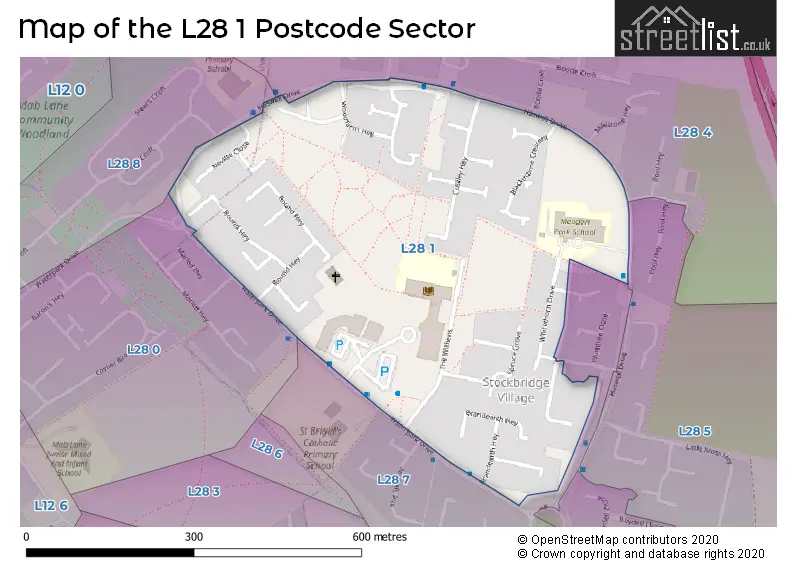
The largest settlements in the L28 1 postal code are LIVERPOOL and Stockbridge Village.
The L28 1 Postcode shares a border with L28 4 (LIVERPOOL), L28 5 (LIVERPOOL, Stockbridge Village), L28 7 (LIVERPOOL, Stockbridge Village), L28 8 (LIVERPOOL) and L28 0 (LIVERPOOL).
The sector is within the post town of LIVERPOOL.
L28 1 is a postcode sector within the L28 postcode district which is within the L Liverpool postcode area.
The Royal Mail delivery office for the L28 1 postal sector is the West Derby Delivery Office.
The area of the L28 1 postcode sector is 0.15 square miles which is 0.38 square kilometres or 94.63 square acres.


Map of the L28 1 Postcode Sector
Explore the L28 1 postcode sector by using our free interactive map.
| L | 2 | 8 | - | 1 | X | X |
| L | 2 | 8 | Space | 1 | Letter | Letter |
Official List of Streets
LIVERPOOL (14 Streets)
Stockbridge Village (3 Streets)
Unofficial Streets or Alternative Spellings
Weather Forecast for L28 1
Press Button to Show Forecast for Croxteth Hall
| Time Period | Icon | Description | Temperature | Rain Probability | Wind |
|---|---|---|---|---|---|
| 06:00 to 09:00 | Overcast | 7.0°C (feels like 4.0°C) | 9.00% | NW 11 mph | |
| 09:00 to 12:00 | Cloudy | 8.0°C (feels like 5.0°C) | 8.00% | NW 13 mph | |
| 12:00 to 15:00 | Light rain shower (day) | 9.0°C (feels like 7.0°C) | 33.00% | N 9 mph | |
| 15:00 to 18:00 | Cloudy | 9.0°C (feels like 7.0°C) | 13.00% | N 9 mph | |
| 18:00 to 21:00 | Cloudy | 8.0°C (feels like 6.0°C) | 8.00% | NW 7 mph | |
| 21:00 to 00:00 | Cloudy | 7.0°C (feels like 5.0°C) | 5.00% | ENE 7 mph |
Press Button to Show Forecast for Croxteth Hall
| Time Period | Icon | Description | Temperature | Rain Probability | Wind |
|---|---|---|---|---|---|
| 00:00 to 03:00 | Partly cloudy (night) | 6.0°C (feels like 4.0°C) | 2.00% | E 7 mph | |
| 03:00 to 06:00 | Clear night | 4.0°C (feels like 2.0°C) | 1.00% | E 7 mph | |
| 06:00 to 09:00 | Sunny day | 4.0°C (feels like 2.0°C) | 2.00% | E 7 mph | |
| 09:00 to 12:00 | Cloudy | 7.0°C (feels like 5.0°C) | 5.00% | E 4 mph | |
| 12:00 to 15:00 | Cloudy | 9.0°C (feels like 8.0°C) | 6.00% | NE 4 mph | |
| 15:00 to 18:00 | Cloudy | 9.0°C (feels like 8.0°C) | 6.00% | N 4 mph | |
| 18:00 to 21:00 | Partly cloudy (day) | 9.0°C (feels like 7.0°C) | 3.00% | NNE 7 mph | |
| 21:00 to 00:00 | Cloudy | 7.0°C (feels like 5.0°C) | 7.00% | NE 9 mph |
Press Button to Show Forecast for Croxteth Hall
| Time Period | Icon | Description | Temperature | Rain Probability | Wind |
|---|---|---|---|---|---|
| 00:00 to 03:00 | Partly cloudy (night) | 5.0°C (feels like 3.0°C) | 4.00% | ESE 9 mph | |
| 03:00 to 06:00 | Partly cloudy (night) | 4.0°C (feels like 2.0°C) | 6.00% | ESE 7 mph | |
| 06:00 to 09:00 | Partly cloudy (day) | 5.0°C (feels like 2.0°C) | 4.00% | E 7 mph | |
| 09:00 to 12:00 | Cloudy | 8.0°C (feels like 6.0°C) | 8.00% | ESE 7 mph | |
| 12:00 to 15:00 | Overcast | 10.0°C (feels like 9.0°C) | 12.00% | E 7 mph | |
| 15:00 to 18:00 | Overcast | 10.0°C (feels like 9.0°C) | 18.00% | NE 7 mph | |
| 18:00 to 21:00 | Cloudy | 10.0°C (feels like 8.0°C) | 13.00% | ENE 9 mph | |
| 21:00 to 00:00 | Cloudy | 8.0°C (feels like 6.0°C) | 13.00% | NE 9 mph |
Press Button to Show Forecast for Croxteth Hall
| Time Period | Icon | Description | Temperature | Rain Probability | Wind |
|---|---|---|---|---|---|
| 00:00 to 03:00 | Light rain | 6.0°C (feels like 4.0°C) | 45.00% | NE 9 mph | |
| 03:00 to 06:00 | Cloudy | 6.0°C (feels like 3.0°C) | 15.00% | NNE 11 mph | |
| 06:00 to 09:00 | Light rain | 7.0°C (feels like 4.0°C) | 49.00% | NNE 11 mph | |
| 09:00 to 12:00 | Light rain | 8.0°C (feels like 5.0°C) | 49.00% | NNE 11 mph | |
| 12:00 to 15:00 | Light rain | 9.0°C (feels like 6.0°C) | 53.00% | N 11 mph | |
| 15:00 to 18:00 | Heavy rain | 10.0°C (feels like 7.0°C) | 70.00% | N 11 mph | |
| 18:00 to 21:00 | Partly cloudy (day) | 10.0°C (feels like 8.0°C) | 14.00% | NNW 11 mph | |
| 21:00 to 00:00 | Partly cloudy (night) | 9.0°C (feels like 7.0°C) | 9.00% | NW 9 mph |
Schools and Places of Education Within the L28 1 Postcode Sector
Meadow Park School
Pupil referral unit
Haswell Drive, Knowsley, Merseyside, L28 1RX
Head: Miss Jacqueline Cleary
Ofsted Rating: Good
Inspection: 2017-06-13 (2508 days ago)
Website: Visit Meadow Park School Website
Phone: 01514778100
Number of Pupils: 50
Stockbridge Village Primary School
Community school
The Withens, Stockbridge Village, Merseyside, L28 1AB
Head: Mr James Austin
Ofsted Rating: Good
Inspection: 2022-11-30 (512 days ago)
Website: Visit Stockbridge Village Primary School Website
Phone: 01514778020
Number of Pupils: 222
House Prices in the L28 1 Postcode Sector
| Type of Property | 2018 Average | 2018 Sales | 2017 Average | 2017 Sales | 2016 Average | 2016 Sales | 2015 Average | 2015 Sales |
|---|---|---|---|---|---|---|---|---|
| Detached | £126,000 | 1 | £118,000 | 1 | £0 | 0 | £105,295 | 1 |
| Semi-Detached | £89,167 | 3 | £86,500 | 2 | £86,500 | 2 | £102,000 | 1 |
| Terraced | £70,000 | 1 | £50,000 | 1 | £61,083 | 6 | £54,667 | 9 |
| Flats | £0 | 0 | £0 | 0 | £0 | 0 | £0 | 0 |
Important Postcodes L28 1 in the Postcode Sector
L28 1AB is the postcode for LEISURE CENTRE, Stockbridge Village Neighbourhood Centre, The Withens
L28 1NW is the postcode for STOCKBRIDGE ACTIVITY BASE, Learning Disabilty Services, Roughsedge Hey
L28 1RX is the postcode for Meadow Park School, Haswell Drive
L28 1ST is the postcode for Stockbridge Village Health Centre, Leachcroft,Waterpark Drive
L28 1SU is the postcode for Heat Wave Leisure, Heat Wave Building, The Withens, Stockbridge Village Primary School, The Withens, Stockbridge Village, Knowsley, and Stockbridge Village Primary School, The Withens
| The L28 1 Sector is within these Local Authorities |
|
|---|---|
| The L28 1 Sector is within these Counties |
|
| The L28 1 Sector is within these Water Company Areas |
|