The L34 0 postcode sector is within the county of Merseyside.
Did you know? According to the 2021 Census, the L34 0 postcode sector is home to a bustling 2,073 residents!
Given that each sector allows for 400 unique postcode combinations. Letters C, I, K, M, O and V are not allowed in the last two letters of a postcode. With 53 postcodes already in use, this leaves 347 units available.
The L34 0 postal code covers the settlement of Knowsley.
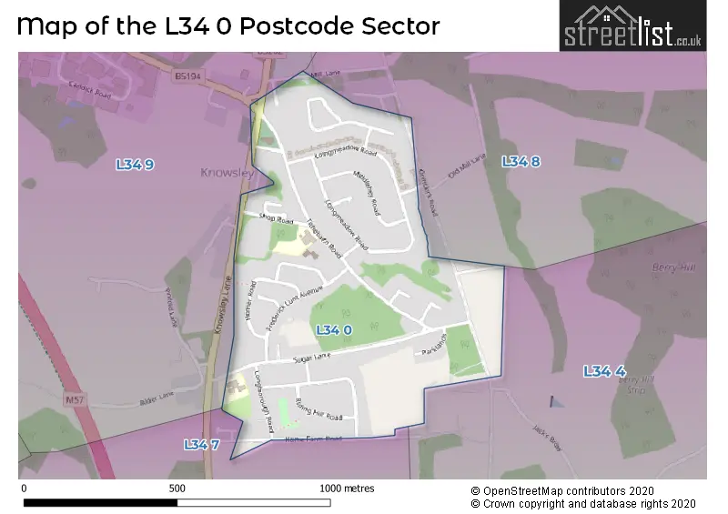
The L34 0 Postcode shares a border with L34 8 (Knowsley), L34 7 (Knowsley), L34 9 (Knowsley, Knowsley Business Park) and L34 4 (Knowsley, Knowsley Park).
The sector is within the post town of PRESCOT.
L34 0 is a postcode sector within the L34 postcode district which is within the L Liverpool postcode area.
The Royal Mail delivery office for the L34 0 postal sector is the Prescot Delivery Office.
The area of the L34 0 postcode sector is 0.30 square miles which is 0.76 square kilometres or 188.82 square acres.

Map of the L34 0 Postcode Sector
Explore the L34 0 postcode sector by using our free interactive map.
| L | 3 | 4 | - | 0 | X | X |
| L | 3 | 4 | Space | 0 | Letter | Letter |
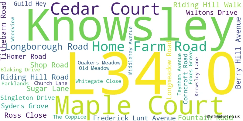
Official List of Streets
Knowsley (30 Streets)
Unofficial Streets or Alternative Spellings
Knowsley
DUMBREEZE GROVE MILL LANE ORMSKIRK ROAD CLORIAN CLOSE MIDDLEHEY ROADKnowsley Business Park
SCHOOL LANEWeather Forecast for L34 0
Press Button to Show Forecast for Croxteth Hall
| Time Period | Icon | Description | Temperature | Rain Probability | Wind |
|---|---|---|---|---|---|
| 21:00 to 00:00 | Cloudy | 7.0°C (feels like 5.0°C) | 5.00% | ENE 7 mph |
Press Button to Show Forecast for Croxteth Hall
| Time Period | Icon | Description | Temperature | Rain Probability | Wind |
|---|---|---|---|---|---|
| 00:00 to 03:00 | Partly cloudy (night) | 6.0°C (feels like 4.0°C) | 2.00% | E 7 mph | |
| 03:00 to 06:00 | Clear night | 4.0°C (feels like 2.0°C) | 1.00% | E 7 mph | |
| 06:00 to 09:00 | Sunny day | 4.0°C (feels like 2.0°C) | 2.00% | E 7 mph | |
| 09:00 to 12:00 | Cloudy | 7.0°C (feels like 5.0°C) | 5.00% | E 4 mph | |
| 12:00 to 15:00 | Cloudy | 9.0°C (feels like 8.0°C) | 6.00% | NE 4 mph | |
| 15:00 to 18:00 | Cloudy | 9.0°C (feels like 8.0°C) | 6.00% | N 4 mph | |
| 18:00 to 21:00 | Partly cloudy (day) | 9.0°C (feels like 7.0°C) | 3.00% | NNE 7 mph | |
| 21:00 to 00:00 | Cloudy | 7.0°C (feels like 5.0°C) | 7.00% | NE 9 mph |
Press Button to Show Forecast for Croxteth Hall
| Time Period | Icon | Description | Temperature | Rain Probability | Wind |
|---|---|---|---|---|---|
| 00:00 to 03:00 | Partly cloudy (night) | 5.0°C (feels like 3.0°C) | 4.00% | ESE 9 mph | |
| 03:00 to 06:00 | Partly cloudy (night) | 4.0°C (feels like 2.0°C) | 6.00% | ESE 7 mph | |
| 06:00 to 09:00 | Partly cloudy (day) | 5.0°C (feels like 2.0°C) | 4.00% | E 7 mph | |
| 09:00 to 12:00 | Cloudy | 8.0°C (feels like 6.0°C) | 8.00% | ESE 7 mph | |
| 12:00 to 15:00 | Overcast | 10.0°C (feels like 9.0°C) | 12.00% | E 7 mph | |
| 15:00 to 18:00 | Overcast | 10.0°C (feels like 9.0°C) | 18.00% | NE 7 mph | |
| 18:00 to 21:00 | Cloudy | 10.0°C (feels like 8.0°C) | 13.00% | ENE 9 mph | |
| 21:00 to 00:00 | Cloudy | 8.0°C (feels like 6.0°C) | 13.00% | NE 9 mph |
Press Button to Show Forecast for Croxteth Hall
| Time Period | Icon | Description | Temperature | Rain Probability | Wind |
|---|---|---|---|---|---|
| 00:00 to 03:00 | Light rain | 6.0°C (feels like 4.0°C) | 45.00% | NE 9 mph | |
| 03:00 to 06:00 | Cloudy | 6.0°C (feels like 3.0°C) | 15.00% | NNE 11 mph | |
| 06:00 to 09:00 | Light rain | 7.0°C (feels like 4.0°C) | 49.00% | NNE 11 mph | |
| 09:00 to 12:00 | Light rain | 8.0°C (feels like 5.0°C) | 49.00% | NNE 11 mph | |
| 12:00 to 15:00 | Light rain | 9.0°C (feels like 6.0°C) | 53.00% | N 11 mph | |
| 15:00 to 18:00 | Heavy rain | 10.0°C (feels like 7.0°C) | 70.00% | N 11 mph | |
| 18:00 to 21:00 | Partly cloudy (day) | 10.0°C (feels like 8.0°C) | 14.00% | NNW 11 mph | |
| 21:00 to 00:00 | Partly cloudy (night) | 9.0°C (feels like 7.0°C) | 9.00% | NW 9 mph |
Schools and Places of Education Within the L34 0 Postcode Sector
Knowsley Village School
Community school
Sugar Lane, Prescot, Merseyside, L34 0ER
Head: Mrs J Barlow
Ofsted Rating: Requires improvement
Inspection: 2023-02-23 (427 days ago)
Website: Visit Knowsley Village School Website
Phone: 01512895349
Number of Pupils: 211
St John Fisher Catholic Primary School
Voluntary aided school
Tithebarn Road, Prescot, Merseyside, L34 0HA
Head: Mrs Claire Lewis
Ofsted Rating: Good
Inspection: 2021-06-10 (1050 days ago)
Website: Visit St John Fisher Catholic Primary School Website
Phone: 01514778590
Number of Pupils: 224
House Prices in the L34 0 Postcode Sector
| Type of Property | 2018 Average | 2018 Sales | 2017 Average | 2017 Sales | 2016 Average | 2016 Sales | 2015 Average | 2015 Sales |
|---|---|---|---|---|---|---|---|---|
| Detached | £264,667 | 9 | £247,571 | 7 | £212,769 | 13 | £231,919 | 13 |
| Semi-Detached | £150,637 | 15 | £156,528 | 9 | £144,590 | 5 | £133,900 | 5 |
| Terraced | £123,750 | 10 | £105,357 | 7 | £102,530 | 15 | £107,350 | 7 |
| Flats | £98,500 | 2 | £98,000 | 1 | £0 | 0 | £80,975 | 2 |
Important Postcodes L34 0 in the Postcode Sector
L34 0ER is the postcode for Knowsley Village Primary School, Sugar Lane, Knowsley, and Knowsley Village Primary School, Sugar Lane
L34 0HA is the postcode for St. John Fisher Primary School, Tithebarn Road
L34 0HF is the postcode for Knowsley medical Centre, Frederick Lunt Avenue, Knowsley
| The L34 0 Sector is within these Local Authorities |
|
|---|---|
| The L34 0 Sector is within these Counties |
|
| The L34 0 Sector is within these Water Company Areas |
|