The L35 postcode district is a postal district located in the L Liverpool postcode area with a population of 30,554 residents according to the 2021 England and Wales Census.
The area of the L35 postcode district is 8.27 square miles which is 21.41 square kilometres or 5,289.71 acres.
Currently, the L35 district has about 688 postcode units spread across 10 geographic postcode sectors.
Given that each sector allows for 400 unique postcode combinations, the district has a capacity of 4,000 postcodes. With 688 postcodes already in use, this leaves 3312 units available.
The largest settlement in the L35 postal code is Rainhill followed by Whiston, and PRESCOT.
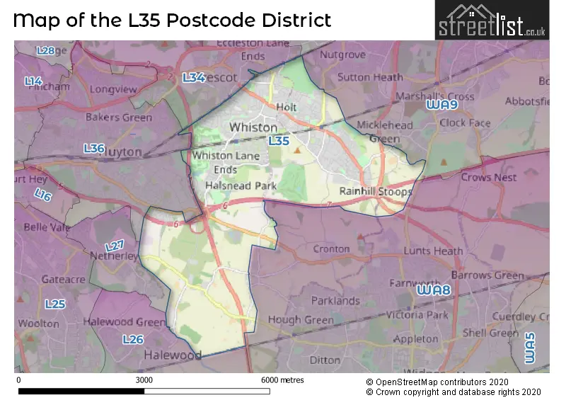
The L35 Postcode shares a border with WA8 (WIDNES), L34 (PRESCOT, Knowsley, Eccleston Park), L36 (LIVERPOOL, Huyton), WA9 (ST. HELENS, Clock Face, Sutton Manor) and L26 (LIVERPOOL, Halewood).
The primary settlement in the L35 postcode district is Prescot, located in the county of Merseyside, England. Other significant settlements in this district include Rainhill, Tarbock Green, Whiston, and Eccleston Park. The most significant post town in the L35 postcode district is Prescot.
For the district L35, we have data on 10 postcode sectors. Here's a breakdown: The sector L35 0, covers Rainhill in Merseyside. The sector L35 1, covers Tarbock Green and Tarbock in Merseyside. The sector L35 2, covers Whiston in Merseyside. The sector L35 3, covers Whiston in Merseyside. The sector L35 4, covers Rainhill in Merseyside. The sector L35 5, covers Prescot in Merseyside. The sector L35 6, covers Rainhill in Merseyside. The sector L35 7, covers Whiston and Prescot in Merseyside. The sector L35 8, covers Rainhill in Merseyside. The sector L35 9, covers Rainhill in Merseyside.


Map of the L35 Postcode District
Explore the L35 postcode district by using our free interactive map.
When it comes to local government, postal geography often disregards political borders. However, for a breakdown in the L35 District: the district mostly encompasses the Knowsley District (B) (403 postcodes), and finally, the St. Helens District (B) area (294 postcodes).
Recent House Sales in L35
| Date | Price | Address |
|---|---|---|
| 11/10/2023 | £85,000 | Blundell Road, Whiston, Prescot, L35 7JP |
| 06/10/2023 | £84,200 | Cook Street, Whiston, Prescot, L35 2UJ |
| 29/09/2023 | £154,000 | Craven Road, Rainhill, Prescot, L35 0LT |
| 21/09/2023 | £225,656 | Juniper Avenue, Whiston, Prescot, L35 1AA |
| 21/09/2023 | £225,657 | Juniper Avenue, Whiston, Prescot, L35 1AA |
| 14/09/2023 | £108,000 | Martock, Whiston, Prescot, L35 3JZ |
| 11/09/2023 | £158,000 | Poplar Grove, Prescot, L35 5AZ |
| 11/09/2023 | £90,000 | Dragon Lane, Whiston, Prescot, L35 3QX |
| 04/09/2023 | £224,995 | Watling Way, Whiston, Prescot, L35 7NG |
| 01/09/2023 | £325,000 | The Meadows, Rainhill, Prescot, L35 0PQ |
Weather Forecast for L35
Press Button to Show Forecast for Whiston Cross
| Time Period | Icon | Description | Temperature | Rain Probability | Wind |
|---|---|---|---|---|---|
| 15:00 to 18:00 | Cloudy | 11.0°C (feels like 9.0°C) | 5.00% | NNW 11 mph | |
| 18:00 to 21:00 | Overcast | 10.0°C (feels like 8.0°C) | 7.00% | NW 11 mph | |
| 21:00 to 00:00 | Overcast | 9.0°C (feels like 7.0°C) | 7.00% | NNW 7 mph |
Press Button to Show Forecast for Whiston Cross
| Time Period | Icon | Description | Temperature | Rain Probability | Wind |
|---|---|---|---|---|---|
| 00:00 to 03:00 | Cloudy | 8.0°C (feels like 7.0°C) | 4.00% | ENE 4 mph | |
| 03:00 to 06:00 | Cloudy | 7.0°C (feels like 5.0°C) | 3.00% | ENE 4 mph | |
| 06:00 to 09:00 | Partly cloudy (day) | 6.0°C (feels like 4.0°C) | 0.00% | NNE 4 mph | |
| 09:00 to 12:00 | Sunny day | 7.0°C (feels like 6.0°C) | 0.00% | NNE 4 mph | |
| 12:00 to 15:00 | Partly cloudy (day) | 10.0°C (feels like 8.0°C) | 1.00% | N 7 mph | |
| 15:00 to 18:00 | Partly cloudy (day) | 11.0°C (feels like 8.0°C) | 1.00% | NW 9 mph | |
| 18:00 to 21:00 | Sunny day | 9.0°C (feels like 7.0°C) | 0.00% | NW 9 mph | |
| 21:00 to 00:00 | Clear night | 7.0°C (feels like 5.0°C) | 1.00% | NW 7 mph |
Press Button to Show Forecast for Whiston Cross
| Time Period | Icon | Description | Temperature | Rain Probability | Wind |
|---|---|---|---|---|---|
| 00:00 to 03:00 | Cloudy | 6.0°C (feels like 4.0°C) | 4.00% | WNW 7 mph | |
| 03:00 to 06:00 | Cloudy | 6.0°C (feels like 4.0°C) | 4.00% | WNW 9 mph | |
| 06:00 to 09:00 | Cloudy | 7.0°C (feels like 4.0°C) | 7.00% | WNW 9 mph | |
| 09:00 to 12:00 | Cloudy | 8.0°C (feels like 5.0°C) | 9.00% | NW 9 mph | |
| 12:00 to 15:00 | Cloudy | 10.0°C (feels like 7.0°C) | 10.00% | NW 11 mph | |
| 15:00 to 18:00 | Cloudy | 10.0°C (feels like 8.0°C) | 6.00% | NW 9 mph | |
| 18:00 to 21:00 | Cloudy | 9.0°C (feels like 8.0°C) | 6.00% | NNW 7 mph | |
| 21:00 to 00:00 | Cloudy | 7.0°C (feels like 6.0°C) | 6.00% | NNE 4 mph |
Press Button to Show Forecast for Whiston Cross
| Time Period | Icon | Description | Temperature | Rain Probability | Wind |
|---|---|---|---|---|---|
| 00:00 to 03:00 | Cloudy | 6.0°C (feels like 4.0°C) | 8.00% | E 7 mph | |
| 03:00 to 06:00 | Cloudy | 5.0°C (feels like 3.0°C) | 10.00% | ESE 7 mph | |
| 06:00 to 09:00 | Cloudy | 5.0°C (feels like 2.0°C) | 11.00% | ESE 7 mph | |
| 09:00 to 12:00 | Cloudy | 7.0°C (feels like 5.0°C) | 12.00% | ESE 7 mph | |
| 12:00 to 15:00 | Overcast | 9.0°C (feels like 7.0°C) | 16.00% | ESE 7 mph | |
| 15:00 to 18:00 | Cloudy | 10.0°C (feels like 8.0°C) | 16.00% | E 7 mph | |
| 18:00 to 21:00 | Cloudy | 9.0°C (feels like 8.0°C) | 11.00% | E 7 mph | |
| 21:00 to 00:00 | Cloudy | 7.0°C (feels like 5.0°C) | 12.00% | E 9 mph |
Press Button to Show Forecast for Whiston Cross
| Time Period | Icon | Description | Temperature | Rain Probability | Wind |
|---|---|---|---|---|---|
| 00:00 to 03:00 | Cloudy | 6.0°C (feels like 4.0°C) | 13.00% | E 7 mph | |
| 03:00 to 06:00 | Cloudy | 6.0°C (feels like 3.0°C) | 18.00% | E 7 mph | |
| 06:00 to 09:00 | Cloudy | 6.0°C (feels like 3.0°C) | 17.00% | ENE 7 mph | |
| 09:00 to 12:00 | Cloudy | 8.0°C (feels like 6.0°C) | 18.00% | E 9 mph | |
| 12:00 to 15:00 | Overcast | 11.0°C (feels like 8.0°C) | 20.00% | ENE 9 mph | |
| 15:00 to 18:00 | Cloudy | 11.0°C (feels like 9.0°C) | 43.00% | ENE 9 mph | |
| 18:00 to 21:00 | Cloudy | 10.0°C (feels like 8.0°C) | 14.00% | NE 9 mph | |
| 21:00 to 00:00 | Cloudy | 9.0°C (feels like 7.0°C) | 15.00% | NE 9 mph |
Where is the L35 Postcode District?
The postcode district L35 is located in Prescot, which is a town in the United Kingdom. It is situated near several other towns, including Widnes to the South East, St. Helens to the North East, Liverpool to the North West, Warrington to the East, Frodsham to the South, and Ellesmere Port to the South West. The distance from L35 to the center of London is approximately 172.52 miles.
The district is within the post town of PRESCOT.
The sector has postcodes within the nation of England.
The L35 Postcode District is in the East Merseyside region of Merseyside within the North West (England).
Postcode Sectors within the L35 District
| Postcode Sector | Delivery Office |
|---|---|
| L35 0 | Prescot Delivery Office |
| L35 1 | Prescot Delivery Office |
| L35 2 | Prescot Delivery Office |
| L35 3 | Prescot Delivery Office |
| L35 4 | Prescot Delivery Office |
| L35 5 | Prescot Delivery Office |
| L35 6 | Prescot Delivery Office |
| L35 7 | Prescot Delivery Office |
| L35 8 | Prescot Delivery Office |
| L35 9 | Prescot Delivery Office |
| L | 3 | 5 | - | X | X | X |
| L | 3 | 5 | Space | Numeric | Letter | Letter |
Current Monthly Rental Prices
| # Bedrooms | Min Price | Max Price | Avg Price |
|---|---|---|---|
| 2 | £600 | £2,000 | £1,125 |
| 3 | £800 | £950 | £900 |
| 4 | £2,200 | £2,200 | £2,200 |
Current House Prices
| # Bedrooms | Min Price | Max Price | Avg Price |
|---|---|---|---|
| 1 | £80,000 | £80,000 | £80,000 |
| 2 | £55,000 | £295,000 | £130,332 |
| 3 | £40,000 | £400,000 | £224,989 |
| 4 | £185,000 | £699,000 | £373,717 |
| 5 | £310,000 | £1,295,000 | £565,905 |
Estate Agents who Operate in the L35 District
| Logo | Name | Brand Name | Address | Contact Number | Total Properties |
|---|---|---|---|---|---|
 | St Helens | Stapleton Derby | 73 Corporation Street St. Helens WA10 1SX | 01744 903754 | 20 |
 | Huyton | Whitegates | 1 Tarbock Road, Roby, Liverpool, L36 5YB | 0151 453 0810 | 20 |
 | Prescot | Brooks Estate and Letting Agents Ltd | 35 Eccleston Street, Prescot, L34 5QA | 0151 453 8027 | 18 |
 | Prescot | Reeds Rains | 18 Eccleston Street Prescot L34 5QE | 0151 453 8584 | 14 |
 | covering Liverpool | Purplebricks | Suite 7 First Floor Cranmore Drive Shirley Solihull B90 4RZ | 020 3907 2647 | 12 |
| Type of Property | 2018 Average | 2018 Sales | 2017 Average | 2017 Sales | 2016 Average | 2016 Sales | 2015 Average | 2015 Sales |
|---|---|---|---|---|---|---|---|---|
| Detached | £259,885 | 81 | £259,940 | 76 | £249,823 | 94 | £233,199 | 81 |
| Semi-Detached | £138,311 | 190 | £135,893 | 193 | £137,961 | 205 | £131,273 | 148 |
| Terraced | £108,626 | 105 | £108,587 | 117 | £98,263 | 106 | £104,219 | 100 |
| Flats | £97,048 | 13 | £71,390 | 20 | £74,745 | 26 | £80,691 | 34 |