The L35 4 postcode sector is within the county of Merseyside.
Did you know? According to the 2021 Census, the L35 4 postcode sector is home to a bustling 3,221 residents!
Given that each sector allows for 400 unique postcode combinations. Letters C, I, K, M, O and V are not allowed in the last two letters of a postcode. With 76 postcodes already in use, this leaves 324 units available.
The L35 4 postal code covers the settlement of Rainhill.
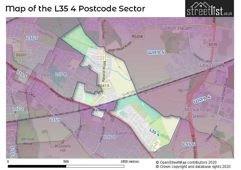
The L35 4 Postcode shares a border with WA9 5 (ST. HELENS, Thatto Heath, Sherdley Road Industrial Estate), WA9 4 (Clock Face, ST. HELENS, Sutton Manor), L35 0 (Rainhill), L35 6 (Rainhill), L35 7 (PRESCOT, Whiston, Eccleston Park), L35 8 (Rainhill) and L35 9 (Rainhill).
The sector is within the post town of PRESCOT.
L35 4 is a postcode sector within the L35 postcode district which is within the L Liverpool postcode area.
The Royal Mail delivery office for the L35 4 postal sector is the Prescot Delivery Office.
The area of the L35 4 postcode sector is 0.46 square miles which is 1.18 square kilometres or 292.04 square acres.

Map of the L35 4 Postcode Sector
Explore the L35 4 postcode sector by using our free interactive map.
| L | 3 | 5 | - | 4 | X | X |
| L | 3 | 5 | Space | 4 | Letter | Letter |
Official List of Streets
Rainhill (48 Streets)
Unofficial Streets or Alternative Spellings
ST. HELENS
ELTON HEAD ROADRainhill
AMANDA ROAD KING EDWARD ROAD NORCLIFFE ROAD RATCLIFFE PLACE SANDON CLOSE STATION ROAD STATION STREET VINCENT ROAD WEAVER AVENUEBold Heath
WARRINGTON ROAD "77 STEPS" ASHFIELD BRAITHAITE CLOSE ELDERSWOOD ROAD HOUGHTON STREET SAINT ANN PLACE SKEW BRIDGE ST JAMES ROADWeather Forecast for L35 4
Press Button to Show Forecast for Thatto Heath
| Time Period | Icon | Description | Temperature | Rain Probability | Wind |
|---|---|---|---|---|---|
| 21:00 to 00:00 | Cloudy | 6.0°C (feels like 4.0°C) | 46.00% | ENE 7 mph |
Press Button to Show Forecast for Thatto Heath
| Time Period | Icon | Description | Temperature | Rain Probability | Wind |
|---|---|---|---|---|---|
| 00:00 to 03:00 | Partly cloudy (night) | 5.0°C (feels like 3.0°C) | 3.00% | E 7 mph | |
| 03:00 to 06:00 | Clear night | 3.0°C (feels like 1.0°C) | 1.00% | E 4 mph | |
| 06:00 to 09:00 | Sunny day | 3.0°C (feels like 1.0°C) | 1.00% | E 4 mph | |
| 09:00 to 12:00 | Partly cloudy (day) | 7.0°C (feels like 5.0°C) | 2.00% | E 4 mph | |
| 12:00 to 15:00 | Cloudy | 9.0°C (feels like 8.0°C) | 9.00% | ENE 4 mph | |
| 15:00 to 18:00 | Cloudy | 10.0°C (feels like 9.0°C) | 9.00% | E 2 mph | |
| 18:00 to 21:00 | Cloudy | 9.0°C (feels like 8.0°C) | 7.00% | ENE 4 mph | |
| 21:00 to 00:00 | Cloudy | 6.0°C (feels like 3.0°C) | 7.00% | NE 7 mph |
Press Button to Show Forecast for Thatto Heath
| Time Period | Icon | Description | Temperature | Rain Probability | Wind |
|---|---|---|---|---|---|
| 00:00 to 03:00 | Partly cloudy (night) | 4.0°C (feels like 2.0°C) | 6.00% | E 7 mph | |
| 03:00 to 06:00 | Partly cloudy (night) | 3.0°C (feels like 0.0°C) | 6.00% | E 4 mph | |
| 06:00 to 09:00 | Partly cloudy (day) | 4.0°C (feels like 1.0°C) | 6.00% | E 7 mph | |
| 09:00 to 12:00 | Cloudy | 8.0°C (feels like 6.0°C) | 8.00% | ESE 7 mph | |
| 12:00 to 15:00 | Overcast | 10.0°C (feels like 8.0°C) | 16.00% | E 7 mph | |
| 15:00 to 18:00 | Cloudy | 11.0°C (feels like 9.0°C) | 18.00% | ENE 9 mph | |
| 18:00 to 21:00 | Cloudy | 10.0°C (feels like 8.0°C) | 15.00% | ENE 9 mph | |
| 21:00 to 00:00 | Partly cloudy (night) | 7.0°C (feels like 5.0°C) | 14.00% | NE 9 mph |
Press Button to Show Forecast for Thatto Heath
| Time Period | Icon | Description | Temperature | Rain Probability | Wind |
|---|---|---|---|---|---|
| 00:00 to 03:00 | Cloudy | 5.0°C (feels like 3.0°C) | 16.00% | NE 7 mph | |
| 03:00 to 06:00 | Cloudy | 5.0°C (feels like 2.0°C) | 17.00% | NNE 9 mph | |
| 06:00 to 09:00 | Cloudy | 6.0°C (feels like 3.0°C) | 21.00% | N 9 mph | |
| 09:00 to 12:00 | Light rain | 8.0°C (feels like 5.0°C) | 52.00% | N 9 mph | |
| 12:00 to 15:00 | Light rain | 9.0°C (feels like 6.0°C) | 56.00% | N 11 mph | |
| 15:00 to 18:00 | Light rain | 9.0°C (feels like 7.0°C) | 51.00% | N 9 mph | |
| 18:00 to 21:00 | Cloudy | 10.0°C (feels like 8.0°C) | 18.00% | N 9 mph | |
| 21:00 to 00:00 | Clear night | 7.0°C (feels like 5.0°C) | 10.00% | NW 7 mph |
Schools and Places of Education Within the L35 4 Postcode Sector
Rainhill Community Nursery
Local authority nursery school
Deepdale Drive, Prescot, Merseyside, L35 4NW
Head: Miss Emma Nicholson
Ofsted Rating: Outstanding
Inspection: 2021-11-18 (889 days ago)
Website: Visit Rainhill Community Nursery Website
Phone: 01744677635
Number of Pupils: 61
House Prices in the L35 4 Postcode Sector
| Type of Property | 2018 Average | 2018 Sales | 2017 Average | 2017 Sales | 2016 Average | 2016 Sales | 2015 Average | 2015 Sales |
|---|---|---|---|---|---|---|---|---|
| Detached | £213,375 | 4 | £243,499 | 4 | £169,375 | 8 | £250,000 | 4 |
| Semi-Detached | £155,143 | 22 | £174,248 | 22 | £156,383 | 18 | £155,381 | 21 |
| Terraced | £119,514 | 18 | £128,684 | 16 | £97,887 | 11 | £112,917 | 12 |
| Flats | £113,197 | 6 | £69,667 | 3 | £73,000 | 1 | £55,000 | 2 |
Important Postcodes L35 4 in the Postcode Sector
L35 4NW is the postcode for Rainhill Community Nursery School, Deepdale Drive
| The L35 4 Sector is within these Local Authorities |
|
|---|---|
| The L35 4 Sector is within these Counties |
|
| The L35 4 Sector is within these Water Company Areas |
|