The L38 postcode district is a postal district located in the L Liverpool postcode area with a population of 2,469 residents according to the 2021 England and Wales Census.
The area of the L38 postcode district is 4.62 square miles which is 11.97 square kilometres or 2,958.58 acres.
Currently, the L38 district has about 99 postcode units spread across 6 geographic postcode sectors.
Given that each sector allows for 400 unique postcode combinations, the district has a capacity of 2,400 postcodes. With 99 postcodes already in use, this leaves 2301 units available.
The largest settlement in the L38 postal code is Hightown followed by LIVERPOOL, and Ince Blundell.
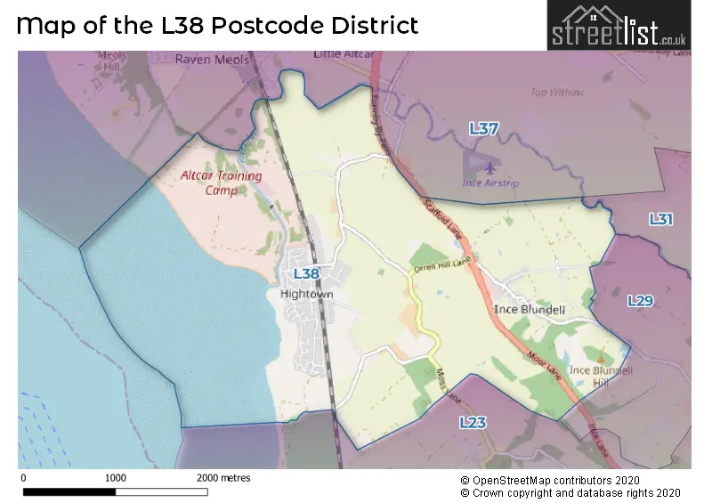
The postcode area has a boundary with The Irish Sea.
The L38 Postcode shares a border with L23 (LIVERPOOL, Crosby, Thornton), L37 (Formby, LIVERPOOL) and L31 (LIVERPOOL, Maghull, Melling).
The primary settlement in the L38 postcode district is Hightown in Liverpool, Merseyside. Other significant settlements in the district include Ince Blundell. The district is located in Merseyside, England. The most significant post town in the district is Liverpool.
For the district L38, we have data on 9 postcode sectors. Here's a breakdown: The sector L38 0, covers Hightown in Merseyside. The sector L38 1, covers Liverpool in Merseyside. The sector L38 3, covers Hightown in Merseyside. The sector L38 4 is non-geographic. It's often designated for PO Boxes, large organisations, or special services. The sector L38 5, covers Hightown and Liverpool in Merseyside. The sector L38 6, covers Ince Blundell and Liverpool in Merseyside. The sector L38 7 is non-geographic. It's often designated for PO Boxes, large organisations, or special services. The sector L38 8 is non-geographic. It's often designated for PO Boxes, large organisations, or special services. The sector L38 9, covers Hightown in Merseyside.

Map of the L38 Postcode District
Explore the L38 postcode district by using our free interactive map.
When it comes to local government, postal geography often disregards political borders. However, for a breakdown in the L38 District: the district mostly encompasses the Sefton District (B) area with a total of 100 postcodes.
Recent House Sales in L38
| Date | Price | Address |
|---|---|---|
| 13/10/2023 | £390,000 | Riverside, Hightown, Liverpool, L38 0BU |
| 02/10/2023 | £340,000 | North Dunes, Hightown, Liverpool, L38 0BS |
| 03/07/2023 | £370,000 | Blundell Grove, Hightown, Liverpool, L38 9EB |
| 24/05/2023 | £630,000 | Elmcroft Lane, Hightown, Liverpool, L38 3RW |
| 24/05/2023 | £675,000 | Back Othe Town Lane, Ince Blundell, Liverpool, L38 6JJ |
| 24/05/2023 | £630,000 | Elmcroft Lane, Hightown, Liverpool, L38 3RW |
| 16/05/2023 | £315,000 | Rathbone Road, Hightown, Liverpool, L38 0BR |
| 05/05/2023 | £785,000 | Elmcroft Lane, Hightown, Liverpool, L38 3RW |
| 27/04/2023 | £245,000 | Carr House Lane, Liverpool, L38 1QG |
| 27/04/2023 | £212,500 | The Roundway, Hightown, Liverpool, L38 9EJ |
Weather Forecast for L38
Press Button to Show Forecast for Crosby
| Time Period | Icon | Description | Temperature | Rain Probability | Wind |
|---|---|---|---|---|---|
| 03:00 to 06:00 | Light rain | 8.0°C (feels like 4.0°C) | 47.00% | WNW 16 mph | |
| 06:00 to 09:00 | Cloudy | 7.0°C (feels like 4.0°C) | 12.00% | NW 16 mph | |
| 09:00 to 12:00 | Cloudy | 8.0°C (feels like 5.0°C) | 43.00% | NW 16 mph | |
| 12:00 to 15:00 | Partly cloudy (day) | 10.0°C (feels like 8.0°C) | 6.00% | NW 11 mph | |
| 15:00 to 18:00 | Partly cloudy (day) | 10.0°C (feels like 8.0°C) | 0.00% | NW 11 mph | |
| 18:00 to 21:00 | Cloudy | 9.0°C (feels like 7.0°C) | 6.00% | NNE 9 mph | |
| 21:00 to 00:00 | Cloudy | 7.0°C (feels like 5.0°C) | 5.00% | ENE 7 mph |
Press Button to Show Forecast for Crosby
| Time Period | Icon | Description | Temperature | Rain Probability | Wind |
|---|---|---|---|---|---|
| 00:00 to 03:00 | Cloudy | 6.0°C (feels like 4.0°C) | 5.00% | E 7 mph | |
| 03:00 to 06:00 | Clear night | 4.0°C (feels like 2.0°C) | 3.00% | E 7 mph | |
| 06:00 to 09:00 | Sunny day | 4.0°C (feels like 2.0°C) | 1.00% | E 7 mph | |
| 09:00 to 12:00 | Cloudy | 7.0°C (feels like 6.0°C) | 5.00% | ESE 4 mph | |
| 12:00 to 15:00 | Cloudy | 10.0°C (feels like 9.0°C) | 6.00% | NNE 7 mph | |
| 15:00 to 18:00 | Cloudy | 10.0°C (feels like 9.0°C) | 6.00% | N 9 mph | |
| 18:00 to 21:00 | Cloudy | 9.0°C (feels like 8.0°C) | 6.00% | NNE 9 mph | |
| 21:00 to 00:00 | Cloudy | 7.0°C (feels like 5.0°C) | 7.00% | NE 9 mph |
Press Button to Show Forecast for Crosby
| Time Period | Icon | Description | Temperature | Rain Probability | Wind |
|---|---|---|---|---|---|
| 00:00 to 03:00 | Partly cloudy (night) | 6.0°C (feels like 3.0°C) | 4.00% | ESE 9 mph | |
| 03:00 to 06:00 | Partly cloudy (night) | 4.0°C (feels like 2.0°C) | 5.00% | ESE 7 mph | |
| 06:00 to 09:00 | Partly cloudy (day) | 5.0°C (feels like 2.0°C) | 4.00% | E 7 mph | |
| 09:00 to 12:00 | Cloudy | 8.0°C (feels like 6.0°C) | 8.00% | ESE 9 mph | |
| 12:00 to 15:00 | Overcast | 11.0°C (feels like 10.0°C) | 12.00% | E 7 mph | |
| 15:00 to 18:00 | Overcast | 11.0°C (feels like 10.0°C) | 18.00% | NE 9 mph | |
| 18:00 to 21:00 | Cloudy | 10.0°C (feels like 8.0°C) | 14.00% | ENE 11 mph | |
| 21:00 to 00:00 | Cloudy | 9.0°C (feels like 6.0°C) | 13.00% | NE 11 mph |
Press Button to Show Forecast for Crosby
| Time Period | Icon | Description | Temperature | Rain Probability | Wind |
|---|---|---|---|---|---|
| 00:00 to 03:00 | Light rain | 7.0°C (feels like 4.0°C) | 45.00% | NE 9 mph | |
| 03:00 to 06:00 | Cloudy | 6.0°C (feels like 3.0°C) | 15.00% | NNE 11 mph | |
| 06:00 to 09:00 | Light rain | 7.0°C (feels like 4.0°C) | 48.00% | NNE 11 mph | |
| 09:00 to 12:00 | Cloudy | 9.0°C (feels like 6.0°C) | 20.00% | NNE 11 mph | |
| 12:00 to 15:00 | Light rain | 11.0°C (feels like 8.0°C) | 50.00% | N 13 mph | |
| 15:00 to 18:00 | Heavy rain | 11.0°C (feels like 8.0°C) | 69.00% | N 13 mph | |
| 18:00 to 21:00 | Partly cloudy (day) | 10.0°C (feels like 8.0°C) | 14.00% | NNW 16 mph | |
| 21:00 to 00:00 | Partly cloudy (night) | 9.0°C (feels like 7.0°C) | 9.00% | WNW 11 mph |
Where is the L38 Postcode District?
The data shows that the L38 postcode district is located in Liverpool. This district is nearby several towns, including Bootle, Wallasey, Ormskirk, Southport, and Skelmersdale. It is also approximately 185.99 miles away from the center of London.
The district is within the post town of LIVERPOOL.
The sector has postcodes within the nation of England.
The L38 Postcode District is in the Sefton region of Merseyside within the North West (England).
| Postcode Sector | Delivery Office |
|---|---|
| L38 0 | Formby Delivery Office |
| L38 1 | Formby Delivery Office |
| L38 2 | Formby Delivery Office |
| L38 3 | Formby Delivery Office |
| L38 4 | Formby Delivery Office |
| L38 5 | Formby Delivery Office |
| L38 6 | Formby Delivery Office |
| L38 7 | Formby Delivery Office |
| L38 8 | Formby Delivery Office |
| L38 9 | Formby Delivery Office |
| L | 3 | 8 | - | X | X | X |
| L | 3 | 8 | Space | Numeric | Letter | Letter |
Current Monthly Rental Prices
| # Bedrooms | Min Price | Max Price | Avg Price |
|---|---|---|---|
| 3 | £1,150 | £1,150 | £1,150 |
| 4 | £2,300 | £2,300 | £2,300 |
Current House Prices
| # Bedrooms | Min Price | Max Price | Avg Price |
|---|---|---|---|
| 2 | £349,000 | £349,000 | £349,000 |
| 3 | £285,000 | £295,000 | £290,000 |
| 4 | £245,000 | £785,000 | £504,286 |
| 5 | £475,000 | £525,000 | £500,000 |
Estate Agents who Operate in the L38 District
| Logo | Name | Brand Name | Address | Contact Number | Total Properties |
|---|---|---|---|---|---|
 | Formby | Entwistle Green | 3 Chapel Lane, Formby, Liverpool, L37 4DL | 01704 334128 | 4 |
 | Liverpool | Logic | 97 South Road, Waterloo, Liverpool, L22 0LR | 0151 453 5490 | 2 |
 | Mossley Hill | Move Residential | 52/54 Allerton Road, Mossley Hill, Liverpool, L18 1LN | 0151 453 1497 | 1 |
 | Crosby | Berkeley Shaw Estate Agents | 35 Liverpool Road, Crosby, Liverpool, L23 5SD | 0151 924 6000 | 1 |
 | Maghull | Alastair Saville | 25 Central Square, Maghull, Liverpool, L31 0AE | 0151 453 5689 | 1 |
| Type of Property | 2018 Average | 2018 Sales | 2017 Average | 2017 Sales | 2016 Average | 2016 Sales | 2015 Average | 2015 Sales |
|---|---|---|---|---|---|---|---|---|
| Detached | £296,667 | 15 | £379,662 | 41 | £295,818 | 22 | £244,817 | 30 |
| Semi-Detached | £240,000 | 10 | £226,186 | 14 | £184,153 | 14 | £192,145 | 10 |
| Terraced | £185,000 | 2 | £227,000 | 2 | £202,500 | 6 | £0 | 0 |
| Flats | £0 | 0 | £144,000 | 3 | £141,000 | 2 | £119,333 | 3 |