The L39 7 postcode sector stands on the Lancashire and Merseyside border.
Did you know? According to the 2021 Census, the L39 7 postcode sector is home to a bustling 1,366 residents!
Given that each sector allows for 400 unique postcode combinations. Letters C, I, K, M, O and V are not allowed in the last two letters of a postcode. With 50 postcodes already in use, this leaves 350 units available.
The largest settlement in the L39 7 postal code is Downholland followed by Aughton, and Haskayne.
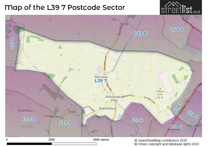
The L39 7 Postcode shares a border with L31 4 (LIVERPOOL, Lydiate, Maghull), L37 9 (Formby, LIVERPOOL), L37 0 (Formby), L39 3 (ORMSKIRK, Aughton), L39 6 (Aughton) and L39 8 (Halsall, Shirdley Hill, ORMSKIRK).
The sector is within the post town of ORMSKIRK.
L39 7 is a postcode sector within the L39 postcode district which is within the L Liverpool postcode area.
The Royal Mail delivery office for the L39 7 postal sector is the Ormskirk Delivery Office.
The area of the L39 7 postcode sector is 7.39 square miles which is 19.15 square kilometres or 4,732.76 square acres.
Waterways within the L39 7 postcode sector include the Leeds and Liverpool Canal.

Map of the L39 7 Postcode Sector
Explore the L39 7 postcode sector by using our free interactive map.
| L | 3 | 9 | - | 7 | X | X |
| L | 3 | 9 | Space | 7 | Letter | Letter |
Official List of Streets
Downholland (15 Streets)
Aughton (11 Streets)
Halsall (4 Streets)
Barton (4 Streets)
Haskayne (7 Streets)
Clieves Hills (1 Streets)
Unofficial Streets or Alternative Spellings
Aughton
BACK LANEDownholland
BLACK-A-MOOR LANE ALDER LANE BACK LANE BELLS LANE BIRCHS BROW CHESHIRE LINES PATH CLIEVES HILL DOWNHOLLAND AND MOSS LANE DOWNHOLLAND CANAL BRIDGE DOWNHOLLAND HALL SWING BRIDGE GREENS LANE HARKERS BRIDGE HEATHY LANE KASKAYNE BRIDGE MOSS BRIDGE NARROW LANE CLIEVES HILLS NEW LANE OLD LANE OLD MOSS LANE PARK CRESCENT SHAW LANE SMALL LANE TRUNDLE PIE LANE WELL LANEFormby
WOOD LANEHalsall
CUT LANE HALSALL LANEWeather Forecast for L39 7
Press Button to Show Forecast for Maghull
| Time Period | Icon | Description | Temperature | Rain Probability | Wind |
|---|---|---|---|---|---|
| 15:00 to 18:00 | Cloudy | 9.0°C (feels like 7.0°C) | 46.00% | N 9 mph | |
| 18:00 to 21:00 | Cloudy | 8.0°C (feels like 6.0°C) | 5.00% | ENE 7 mph | |
| 21:00 to 00:00 | Cloudy | 7.0°C (feels like 5.0°C) | 5.00% | ENE 7 mph |
Press Button to Show Forecast for Maghull
| Time Period | Icon | Description | Temperature | Rain Probability | Wind |
|---|---|---|---|---|---|
| 00:00 to 03:00 | Cloudy | 6.0°C (feels like 3.0°C) | 5.00% | E 7 mph | |
| 03:00 to 06:00 | Clear night | 4.0°C (feels like 2.0°C) | 2.00% | E 7 mph | |
| 06:00 to 09:00 | Partly cloudy (day) | 4.0°C (feels like 2.0°C) | 2.00% | E 4 mph | |
| 09:00 to 12:00 | Cloudy | 7.0°C (feels like 6.0°C) | 6.00% | E 4 mph | |
| 12:00 to 15:00 | Cloudy | 9.0°C (feels like 8.0°C) | 6.00% | N 4 mph | |
| 15:00 to 18:00 | Cloudy | 9.0°C (feels like 8.0°C) | 6.00% | N 7 mph | |
| 18:00 to 21:00 | Partly cloudy (day) | 9.0°C (feels like 7.0°C) | 3.00% | NNE 7 mph | |
| 21:00 to 00:00 | Cloudy | 7.0°C (feels like 5.0°C) | 7.00% | NE 9 mph |
Press Button to Show Forecast for Maghull
| Time Period | Icon | Description | Temperature | Rain Probability | Wind |
|---|---|---|---|---|---|
| 00:00 to 03:00 | Partly cloudy (night) | 5.0°C (feels like 3.0°C) | 4.00% | ESE 9 mph | |
| 03:00 to 06:00 | Partly cloudy (night) | 4.0°C (feels like 2.0°C) | 5.00% | ESE 7 mph | |
| 06:00 to 09:00 | Partly cloudy (day) | 5.0°C (feels like 2.0°C) | 4.00% | E 7 mph | |
| 09:00 to 12:00 | Cloudy | 8.0°C (feels like 6.0°C) | 8.00% | ESE 7 mph | |
| 12:00 to 15:00 | Overcast | 10.0°C (feels like 9.0°C) | 12.00% | E 7 mph | |
| 15:00 to 18:00 | Overcast | 10.0°C (feels like 9.0°C) | 18.00% | NE 7 mph | |
| 18:00 to 21:00 | Cloudy | 10.0°C (feels like 8.0°C) | 14.00% | ENE 9 mph | |
| 21:00 to 00:00 | Cloudy | 8.0°C (feels like 6.0°C) | 13.00% | ENE 9 mph |
Press Button to Show Forecast for Maghull
| Time Period | Icon | Description | Temperature | Rain Probability | Wind |
|---|---|---|---|---|---|
| 00:00 to 03:00 | Light rain | 6.0°C (feels like 4.0°C) | 45.00% | NE 9 mph | |
| 03:00 to 06:00 | Cloudy | 6.0°C (feels like 3.0°C) | 15.00% | NNE 11 mph | |
| 06:00 to 09:00 | Light rain | 7.0°C (feels like 4.0°C) | 48.00% | NNE 11 mph | |
| 09:00 to 12:00 | Cloudy | 8.0°C (feels like 5.0°C) | 20.00% | NNE 11 mph | |
| 12:00 to 15:00 | Light rain | 9.0°C (feels like 6.0°C) | 52.00% | N 11 mph | |
| 15:00 to 18:00 | Heavy rain | 10.0°C (feels like 7.0°C) | 70.00% | NNW 11 mph | |
| 18:00 to 21:00 | Partly cloudy (day) | 10.0°C (feels like 8.0°C) | 15.00% | WNW 11 mph | |
| 21:00 to 00:00 | Partly cloudy (night) | 9.0°C (feels like 7.0°C) | 9.00% | WNW 9 mph |
Schools and Places of Education Within the L39 7 Postcode Sector
Downholland-Haskayne Voluntary Aided Church of England Primary School
Voluntary aided school
Black-A-Moor Lane, Ormskirk, Lancashire, L39 7HX
Head: Mrs Jane Smethurst
Ofsted Rating: Good
Inspection: 2018-12-13 (1960 days ago)
Website: Visit Downholland-Haskayne Voluntary Aided Church of England Primary School Website
Phone: 01515260614
Number of Pupils: 43
House Prices in the L39 7 Postcode Sector
| Type of Property | 2018 Average | 2018 Sales | 2017 Average | 2017 Sales | 2016 Average | 2016 Sales | 2015 Average | 2015 Sales |
|---|---|---|---|---|---|---|---|---|
| Detached | £390,139 | 9 | £380,000 | 9 | £336,814 | 11 | £296,102 | 13 |
| Semi-Detached | £225,950 | 10 | £227,250 | 11 | £177,333 | 6 | £233,667 | 3 |
| Terraced | £110,000 | 1 | £201,570 | 4 | £152,500 | 1 | £194,579 | 5 |
| Flats | £0 | 0 | £0 | 0 | £97,500 | 1 | £0 | 0 |
| The L39 7 Sector is within these Local Authorities |
|
|---|---|
| The L39 7 Sector is within these Counties |
|
| The L39 7 Sector is within these Water Company Areas |
|