The L39 9 postcode sector is within the county of Lancashire.
Did you know? According to the 2021 Census, the L39 9 postcode sector is home to a bustling 160 residents!
Given that each sector allows for 400 unique postcode combinations. Letters C, I, K, M, O and V are not allowed in the last two letters of a postcode. With 15 postcodes already in use, this leaves 385 units available.
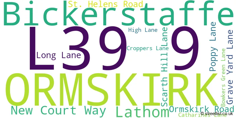
The largest settlement in the L39 9 postal code is Bickerstaffe followed by Lathom, and ORMSKIRK.
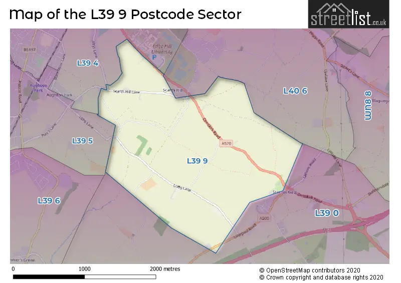
The L39 9 Postcode shares a border with L39 4 (ORMSKIRK, Aughton), L39 0 (Bickerstaffe), L39 5 (Aughton) and L40 6 (Westhead, Lathom).
The sector is within the post town of ORMSKIRK.
L39 9 is a postcode sector within the L39 postcode district which is within the L Liverpool postcode area.
The Royal Mail delivery office for the L39 9 postal sector is the Ormskirk Delivery Office.
The area of the L39 9 postcode sector is 1.78 square miles which is 4.62 square kilometres or 1,140.89 square acres.

Map of the L39 9 Postcode Sector
Explore the L39 9 postcode sector by using our free interactive map.
| L | 3 | 9 | - | 9 | X | X |
| L | 3 | 9 | Space | 9 | Letter | Letter |
Official List of Streets
Bickerstaffe (8 Streets)
ORMSKIRK (2 Streets)
Lathom (2 Streets)
Unofficial Streets or Alternative Spellings
Lathom
WHITELEYS LANEBickerstaffe
LIVERPOOL ROADORMSKIRK
ALTYS LANEAughton
LONG LANE MALTKILN LANE SCARTH HILL LANE GRAVE-YARD LANEWeather Forecast for L39 9
Press Button to Show Forecast for Ormskirk
| Time Period | Icon | Description | Temperature | Rain Probability | Wind |
|---|---|---|---|---|---|
| 21:00 to 00:00 | Overcast | 9.0°C (feels like 7.0°C) | 7.00% | NNW 7 mph |
Press Button to Show Forecast for Ormskirk
| Time Period | Icon | Description | Temperature | Rain Probability | Wind |
|---|---|---|---|---|---|
| 00:00 to 03:00 | Cloudy | 8.0°C (feels like 7.0°C) | 4.00% | SSW 4 mph | |
| 03:00 to 06:00 | Cloudy | 7.0°C (feels like 5.0°C) | 3.00% | NE 4 mph | |
| 06:00 to 09:00 | Partly cloudy (day) | 5.0°C (feels like 3.0°C) | 0.00% | NNE 7 mph | |
| 09:00 to 12:00 | Partly cloudy (day) | 7.0°C (feels like 5.0°C) | 1.00% | NNE 7 mph | |
| 12:00 to 15:00 | Partly cloudy (day) | 9.0°C (feels like 7.0°C) | 0.00% | NNW 7 mph | |
| 15:00 to 18:00 | Partly cloudy (day) | 9.0°C (feels like 6.0°C) | 1.00% | NW 11 mph | |
| 18:00 to 21:00 | Sunny day | 8.0°C (feels like 6.0°C) | 1.00% | NW 9 mph | |
| 21:00 to 00:00 | Partly cloudy (night) | 7.0°C (feels like 5.0°C) | 1.00% | WNW 7 mph |
Press Button to Show Forecast for Ormskirk
| Time Period | Icon | Description | Temperature | Rain Probability | Wind |
|---|---|---|---|---|---|
| 00:00 to 03:00 | Cloudy | 7.0°C (feels like 4.0°C) | 4.00% | WNW 9 mph | |
| 03:00 to 06:00 | Cloudy | 7.0°C (feels like 4.0°C) | 5.00% | WNW 11 mph | |
| 06:00 to 09:00 | Cloudy | 7.0°C (feels like 4.0°C) | 7.00% | NW 11 mph | |
| 09:00 to 12:00 | Partly cloudy (day) | 8.0°C (feels like 5.0°C) | 5.00% | NW 11 mph | |
| 12:00 to 15:00 | Partly cloudy (day) | 9.0°C (feels like 6.0°C) | 4.00% | NW 11 mph | |
| 15:00 to 18:00 | Partly cloudy (day) | 9.0°C (feels like 7.0°C) | 2.00% | NW 11 mph | |
| 18:00 to 21:00 | Partly cloudy (day) | 9.0°C (feels like 7.0°C) | 2.00% | NW 9 mph | |
| 21:00 to 00:00 | Cloudy | 7.0°C (feels like 5.0°C) | 8.00% | NE 7 mph |
Press Button to Show Forecast for Ormskirk
| Time Period | Icon | Description | Temperature | Rain Probability | Wind |
|---|---|---|---|---|---|
| 00:00 to 03:00 | Cloudy | 6.0°C (feels like 4.0°C) | 8.00% | ESE 7 mph | |
| 03:00 to 06:00 | Cloudy | 5.0°C (feels like 3.0°C) | 9.00% | ESE 7 mph | |
| 06:00 to 09:00 | Cloudy | 5.0°C (feels like 2.0°C) | 13.00% | ESE 9 mph | |
| 09:00 to 12:00 | Cloudy | 7.0°C (feels like 4.0°C) | 11.00% | ESE 9 mph | |
| 12:00 to 15:00 | Overcast | 9.0°C (feels like 7.0°C) | 15.00% | E 9 mph | |
| 15:00 to 18:00 | Cloudy | 10.0°C (feels like 8.0°C) | 13.00% | E 7 mph | |
| 18:00 to 21:00 | Cloudy | 9.0°C (feels like 8.0°C) | 11.00% | E 7 mph | |
| 21:00 to 00:00 | Cloudy | 8.0°C (feels like 5.0°C) | 12.00% | ENE 9 mph |
Press Button to Show Forecast for Ormskirk
| Time Period | Icon | Description | Temperature | Rain Probability | Wind |
|---|---|---|---|---|---|
| 00:00 to 03:00 | Cloudy | 7.0°C (feels like 4.0°C) | 12.00% | E 9 mph | |
| 03:00 to 06:00 | Cloudy | 6.0°C (feels like 3.0°C) | 16.00% | E 9 mph | |
| 06:00 to 09:00 | Overcast | 6.0°C (feels like 3.0°C) | 19.00% | E 9 mph | |
| 09:00 to 12:00 | Cloudy | 8.0°C (feels like 5.0°C) | 15.00% | E 11 mph | |
| 12:00 to 15:00 | Overcast | 10.0°C (feels like 8.0°C) | 17.00% | E 11 mph | |
| 15:00 to 18:00 | Cloudy | 11.0°C (feels like 9.0°C) | 41.00% | ENE 11 mph | |
| 18:00 to 21:00 | Cloudy | 10.0°C (feels like 8.0°C) | 13.00% | NE 11 mph | |
| 21:00 to 00:00 | Cloudy | 9.0°C (feels like 6.0°C) | 14.00% | ENE 11 mph |
House Prices in the L39 9 Postcode Sector
| Type of Property | 2018 Average | 2018 Sales | 2017 Average | 2017 Sales | 2016 Average | 2016 Sales | 2015 Average | 2015 Sales |
|---|---|---|---|---|---|---|---|---|
| Detached | £0 | 0 | £397,500 | 2 | £0 | 0 | £431,500 | 1 |
| Semi-Detached | £0 | 0 | £0 | 0 | £0 | 0 | £235,000 | 1 |
| Terraced | £0 | 0 | £0 | 0 | £0 | 0 | £0 | 0 |
| Flats | £0 | 0 | £0 | 0 | £0 | 0 | £0 | 0 |
| The L39 9 Sector is within these Local Authorities |
|
|---|---|
| The L39 9 Sector is within these Counties |
|
| The L39 9 Sector is within these Water Company Areas |
|