The L5 2 postcode sector is within the county of Merseyside.
Did you know? According to the 2021 Census, the L5 2 postcode sector is home to a bustling 1,242 residents!
Given that each sector allows for 400 unique postcode combinations. Letters C, I, K, M, O and V are not allowed in the last two letters of a postcode. With 49 postcodes already in use, this leaves 351 units available.
The largest settlements in the L5 2 postal code are LIVERPOOL and Kirkdale.
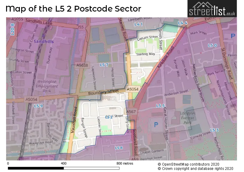
The L5 2 Postcode shares a border with L5 9 (LIVERPOOL, Kirkdale), L4 1 (LIVERPOOL, Kirkdale), L5 8 (LIVERPOOL), L4 4 (LIVERPOOL, Kirkdale), L5 5 (LIVERPOOL) and L5 7 (LIVERPOOL, Kirkdale).
The sector is within the post town of LIVERPOOL.
L5 2 is a postcode sector within the L5 postcode district which is within the L Liverpool postcode area.
The Royal Mail delivery office for the L5 2 postal sector is the Liverpool 4-5.
The area of the L5 2 postcode sector is 0.10 square miles which is 0.26 square kilometres or 65.32 square acres.
Waterways within the L5 2 postcode sector include the Leeds and Liverpool Canal.

Map of the L5 2 Postcode Sector
Explore the L5 2 postcode sector by using our free interactive map.
| L | 5 | - | 2 | X | X |
| L | 5 | Space | 2 | Letter | Letter |
Official List of Streets
LIVERPOOL (29 Streets)
Unofficial Streets or Alternative Spellings
Weather Forecast for L5 2
Press Button to Show Forecast for Liverpool
| Time Period | Icon | Description | Temperature | Rain Probability | Wind |
|---|---|---|---|---|---|
| 09:00 to 12:00 | Cloudy | 8.0°C (feels like 5.0°C) | 11.00% | NW 13 mph | |
| 12:00 to 15:00 | Partly cloudy (day) | 10.0°C (feels like 7.0°C) | 3.00% | NW 11 mph | |
| 15:00 to 18:00 | Cloudy | 10.0°C (feels like 7.0°C) | 12.00% | NNW 11 mph | |
| 18:00 to 21:00 | Cloudy | 9.0°C (feels like 7.0°C) | 7.00% | NNE 7 mph | |
| 21:00 to 00:00 | Cloudy | 7.0°C (feels like 5.0°C) | 4.00% | ENE 7 mph |
Press Button to Show Forecast for Liverpool
| Time Period | Icon | Description | Temperature | Rain Probability | Wind |
|---|---|---|---|---|---|
| 00:00 to 03:00 | Cloudy | 6.0°C (feels like 4.0°C) | 5.00% | E 7 mph | |
| 03:00 to 06:00 | Clear night | 5.0°C (feels like 2.0°C) | 2.00% | E 7 mph | |
| 06:00 to 09:00 | Partly cloudy (day) | 4.0°C (feels like 2.0°C) | 1.00% | E 7 mph | |
| 09:00 to 12:00 | Partly cloudy (day) | 7.0°C (feels like 6.0°C) | 1.00% | E 4 mph | |
| 12:00 to 15:00 | Cloudy | 9.0°C (feels like 8.0°C) | 6.00% | NNE 4 mph | |
| 15:00 to 18:00 | Cloudy | 10.0°C (feels like 8.0°C) | 6.00% | N 7 mph | |
| 18:00 to 21:00 | Cloudy | 9.0°C (feels like 8.0°C) | 6.00% | NNE 7 mph | |
| 21:00 to 00:00 | Cloudy | 7.0°C (feels like 5.0°C) | 8.00% | NE 9 mph |
Press Button to Show Forecast for Liverpool
| Time Period | Icon | Description | Temperature | Rain Probability | Wind |
|---|---|---|---|---|---|
| 00:00 to 03:00 | Partly cloudy (night) | 6.0°C (feels like 3.0°C) | 6.00% | ESE 9 mph | |
| 03:00 to 06:00 | Partly cloudy (night) | 4.0°C (feels like 2.0°C) | 6.00% | ESE 7 mph | |
| 06:00 to 09:00 | Partly cloudy (day) | 5.0°C (feels like 2.0°C) | 5.00% | E 7 mph | |
| 09:00 to 12:00 | Cloudy | 8.0°C (feels like 6.0°C) | 8.00% | ESE 7 mph | |
| 12:00 to 15:00 | Overcast | 10.0°C (feels like 9.0°C) | 14.00% | E 7 mph | |
| 15:00 to 18:00 | Cloudy | 11.0°C (feels like 9.0°C) | 18.00% | NE 7 mph | |
| 18:00 to 21:00 | Cloudy | 10.0°C (feels like 8.0°C) | 15.00% | ENE 9 mph | |
| 21:00 to 00:00 | Partly cloudy (night) | 9.0°C (feels like 6.0°C) | 13.00% | NE 9 mph |
Press Button to Show Forecast for Liverpool
| Time Period | Icon | Description | Temperature | Rain Probability | Wind |
|---|---|---|---|---|---|
| 00:00 to 03:00 | Cloudy | 7.0°C (feels like 4.0°C) | 17.00% | NE 9 mph | |
| 03:00 to 06:00 | Cloudy | 6.0°C (feels like 3.0°C) | 16.00% | NNE 11 mph | |
| 06:00 to 09:00 | Light rain | 7.0°C (feels like 4.0°C) | 47.00% | NNE 11 mph | |
| 09:00 to 12:00 | Light rain | 8.0°C (feels like 5.0°C) | 49.00% | NNE 11 mph | |
| 12:00 to 15:00 | Light rain | 9.0°C (feels like 6.0°C) | 52.00% | NNE 11 mph | |
| 15:00 to 18:00 | Light rain | 10.0°C (feels like 7.0°C) | 52.00% | N 11 mph | |
| 18:00 to 21:00 | Partly cloudy (day) | 10.0°C (feels like 8.0°C) | 13.00% | WNW 13 mph | |
| 21:00 to 00:00 | Clear night | 9.0°C (feels like 7.0°C) | 11.00% | WNW 11 mph |
House Prices in the L5 2 Postcode Sector
| Type of Property | 2018 Average | 2018 Sales | 2017 Average | 2017 Sales | 2016 Average | 2016 Sales | 2015 Average | 2015 Sales |
|---|---|---|---|---|---|---|---|---|
| Detached | £0 | 0 | £0 | 0 | £0 | 0 | £0 | 0 |
| Semi-Detached | £125,000 | 1 | £90,000 | 1 | £0 | 0 | £65,417 | 3 |
| Terraced | £136,490 | 15 | £97,000 | 6 | £74,000 | 3 | £149,964 | 1 |
| Flats | £91,667 | 3 | £81,425 | 20 | £0 | 0 | £63,583 | 3 |
Important Postcodes L5 2 in the Postcode Sector
L5 2QD is the postcode for North Liverpool Community Justice Centre, Boundary Street
| The L5 2 Sector is within these Local Authorities |
|
|---|---|
| The L5 2 Sector is within these Counties |
|
| The L5 2 Sector is within these Water Company Areas |
|