The L7 postcode district is a postal district located in the L Liverpool postcode area with a population of 21,614 residents according to the 2021 England and Wales Census.
The area of the L7 postcode district is 1.33 square miles which is 3.43 square kilometres or 848.43 acres.
Currently, the L7 district has about 454 postcode units spread across 10 geographic postcode sectors.
Given that each sector allows for 400 unique postcode combinations, the district has a capacity of 4,000 postcodes. With 454 postcodes already in use, this leaves 3546 units available.
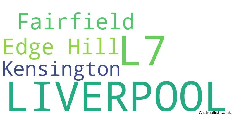
The largest settlement in the L7 postal code is LIVERPOOL followed by Fairfield, and Kensington.
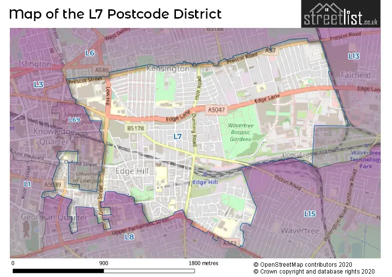
The L7 Postcode shares a border with L3 (LIVERPOOL, Brunswick Business Park), L13 (LIVERPOOL, Old Swan, Tuebrook), L69 (LIVERPOOL, BOOTLE), L15 (LIVERPOOL, Wavertree), L6 (LIVERPOOL, Anfield, Fairfield) and L8 (LIVERPOOL, Toxteth, Princes Park).
The primary settlement in the L7 postcode district is Liverpool, located in the county of Merseyside, England.
For the district L7, we have data on 10 postcode sectors. Here's a breakdown: The sector L7 0, covers Liverpool and Fairfield in Merseyside. The sector L7 1, covers Liverpool in Merseyside. The sector L7 2, covers Liverpool and Edge Hill in Merseyside. The sector L7 3, covers Liverpool in Merseyside. The sector L7 4, covers Liverpool in Merseyside. The sector L7 5, covers Liverpool in Merseyside. The sector L7 6, covers Liverpool in Merseyside. The sector L7 7, covers Liverpool and Edge Hill in Merseyside. The sector L7 8, covers Liverpool and Kensington in Merseyside. The sector L7 9, covers Liverpool and Fairfield in Merseyside.

Map of the L7 Postcode District
Explore the L7 postcode district by using our free interactive map.
When it comes to local government, postal geography often disregards political borders. However, for a breakdown in the L7 District: the district mostly encompasses the Liverpool District (B) area with a total of 462 postcodes.
Recent House Sales in L7
| Date | Price | Address |
|---|---|---|
| 24/10/2023 | £39,710 | Lindale Road, Liverpool, L7 0JS |
| 13/10/2023 | £18,000 | Earle Road, Liverpool, L7 6HH |
| 10/10/2023 | £108,000 | Holland Street, Liverpool, L7 0JG |
| 27/09/2023 | £280,000 | Marrow Drive, Liverpool, L7 0AB |
| 07/09/2023 | £300,000 | Hall Lane, Kensington, Liverpool, L7 8TE |
| 31/08/2023 | £190,000 | Wavertree Road, Liverpool, L7 1PE |
| 18/08/2023 | £195,000 | Connaught Road, Liverpool, L7 8RW |
| 16/08/2023 | £234,000 | Chatham Street, Liverpool, L7 7BA |
| 14/08/2023 | £180,000 | Fell Street, Liverpool, L7 2QD |
| 11/08/2023 | £161,000 | Connaught Road, Liverpool, L7 8RP |
Weather Forecast for L7
Press Button to Show Forecast for Edge Hill
| Time Period | Icon | Description | Temperature | Rain Probability | Wind |
|---|---|---|---|---|---|
| 09:00 to 12:00 | Sunny day | 7.0°C (feels like 5.0°C) | 0.00% | NNE 7 mph | |
| 12:00 to 15:00 | Partly cloudy (day) | 9.0°C (feels like 7.0°C) | 1.00% | NW 9 mph | |
| 15:00 to 18:00 | Sunny day | 10.0°C (feels like 7.0°C) | 1.00% | NW 11 mph | |
| 18:00 to 21:00 | Sunny day | 9.0°C (feels like 6.0°C) | 0.00% | NW 9 mph | |
| 21:00 to 00:00 | Clear night | 8.0°C (feels like 6.0°C) | 1.00% | NW 9 mph |
Press Button to Show Forecast for Edge Hill
| Time Period | Icon | Description | Temperature | Rain Probability | Wind |
|---|---|---|---|---|---|
| 00:00 to 03:00 | Cloudy | 7.0°C (feels like 5.0°C) | 4.00% | WNW 9 mph | |
| 03:00 to 06:00 | Cloudy | 7.0°C (feels like 4.0°C) | 4.00% | WNW 11 mph | |
| 06:00 to 09:00 | Cloudy | 7.0°C (feels like 4.0°C) | 7.00% | NW 11 mph | |
| 09:00 to 12:00 | Cloudy | 8.0°C (feels like 5.0°C) | 9.00% | NW 13 mph | |
| 12:00 to 15:00 | Partly cloudy (day) | 9.0°C (feels like 6.0°C) | 6.00% | NW 11 mph | |
| 15:00 to 18:00 | Partly cloudy (day) | 10.0°C (feels like 7.0°C) | 2.00% | NW 11 mph | |
| 18:00 to 21:00 | Cloudy | 9.0°C (feels like 7.0°C) | 5.00% | NW 9 mph | |
| 21:00 to 00:00 | Cloudy | 8.0°C (feels like 6.0°C) | 5.00% | N 7 mph |
Press Button to Show Forecast for Edge Hill
| Time Period | Icon | Description | Temperature | Rain Probability | Wind |
|---|---|---|---|---|---|
| 00:00 to 03:00 | Cloudy | 7.0°C (feels like 5.0°C) | 7.00% | E 7 mph | |
| 03:00 to 06:00 | Cloudy | 6.0°C (feels like 3.0°C) | 11.00% | SE 7 mph | |
| 06:00 to 09:00 | Cloudy | 5.0°C (feels like 3.0°C) | 11.00% | ESE 7 mph | |
| 09:00 to 12:00 | Cloudy | 7.0°C (feels like 5.0°C) | 12.00% | SE 9 mph | |
| 12:00 to 15:00 | Overcast | 9.0°C (feels like 7.0°C) | 15.00% | E 9 mph | |
| 15:00 to 18:00 | Overcast | 10.0°C (feels like 8.0°C) | 18.00% | ENE 7 mph | |
| 18:00 to 21:00 | Cloudy | 9.0°C (feels like 8.0°C) | 12.00% | E 7 mph | |
| 21:00 to 00:00 | Overcast | 8.0°C (feels like 6.0°C) | 16.00% | ENE 9 mph |
Press Button to Show Forecast for Edge Hill
| Time Period | Icon | Description | Temperature | Rain Probability | Wind |
|---|---|---|---|---|---|
| 00:00 to 03:00 | Overcast | 7.0°C (feels like 4.0°C) | 17.00% | ENE 9 mph | |
| 03:00 to 06:00 | Overcast | 6.0°C (feels like 4.0°C) | 21.00% | E 9 mph | |
| 06:00 to 09:00 | Cloudy | 6.0°C (feels like 4.0°C) | 17.00% | E 9 mph | |
| 09:00 to 12:00 | Cloudy | 8.0°C (feels like 5.0°C) | 16.00% | E 9 mph | |
| 12:00 to 15:00 | Overcast | 10.0°C (feels like 8.0°C) | 19.00% | E 9 mph | |
| 15:00 to 18:00 | Cloudy | 11.0°C (feels like 9.0°C) | 17.00% | ENE 11 mph | |
| 18:00 to 21:00 | Cloudy | 10.0°C (feels like 8.0°C) | 15.00% | ENE 9 mph | |
| 21:00 to 00:00 | Cloudy | 9.0°C (feels like 7.0°C) | 15.00% | ENE 9 mph |
Where is the L7 Postcode District?
The postcode district L7 is located in Liverpool, which is a town in the United Kingdom. Liverpool is the district town for this postcode. It is worth noting that L7 is approximately 177.18 miles away from the center of London. In terms of nearby towns, L7 is surrounded by several towns: Wallasey, Bootle, Birkenhead, Prescot, and Ellesmere Port. Wallasey is located to the west of L7, Bootle to the north, Birkenhead to the southwest, Prescot to the east, and Ellesmere Port to the south.
The district is within the post town of LIVERPOOL.
The sector has postcodes within the nation of England.
The L7 Postcode District is in the Liverpool region of Merseyside within the North West (England).
| Postcode Sector | Delivery Office |
|---|---|
| L7 0 | Liverpool 6-7 |
| L7 1 | Liverpool 6-7 |
| L7 2 | Liverpool 6-7 |
| L7 3 | Liverpool 6-7 |
| L7 4 | Liverpool 6-7 |
| L7 5 | Liverpool 6-7 |
| L7 6 | Liverpool 6-7 |
| L7 7 | Liverpool 6-7 |
| L7 8 | Liverpool 6-7 |
| L7 9 | Liverpool 6-7 |
| L | 7 | - | X | X | X |
| L | 7 | Space | Numeric | Letter | Letter |
Current Monthly Rental Prices
| # Bedrooms | Min Price | Max Price | Avg Price |
|---|---|---|---|
| £325 | £1,018 | £630 | |
| 1 | £368 | £672 | £498 |
| 2 | £105 | £1,300 | £650 |
| 3 | £368 | £1,235 | £644 |
| 4 | £368 | £1,924 | £719 |
| 5 | £390 | £2,492 | £808 |
| 6 | £347 | £2,887 | £804 |
| 7 | £368 | £477 | £423 |
| 8 | £347 | £433 | £383 |
| 9 | £412 | £563 | £493 |
| 11 | £425 | £425 | £425 |
Current House Prices
| # Bedrooms | Min Price | Max Price | Avg Price |
|---|---|---|---|
| £25,000 | £60,000 | £38,269 | |
| 1 | £37,500 | £120,000 | £64,549 |
| 2 | £75,000 | £290,000 | £127,206 |
| 3 | £77,500 | £270,000 | £150,123 |
| 4 | £150,000 | £275,000 | £210,000 |
| 5 | £210,000 | £300,000 | £255,000 |
| 6 | £210,000 | £530,000 | £360,000 |
| 7 | £350,000 | £350,000 | £350,000 |
| 8 | £185,000 | £185,000 | £185,000 |
| 9 | £750,000 | £750,000 | £750,000 |
Estate Agents who Operate in the L7 District
| Logo | Name | Brand Name | Address | Contact Number | Total Properties |
|---|---|---|---|---|---|
 | Liverpool | Address Properties | 183 - 185 Rose Lane, Mossley Hill, Liverpool, L18 5EA | 0151 453 2756 | 30 |
 | Liverpool | Rooms4u | 467a Smithdown Road, Wavertree, Liverpool, L15 5AE | 0151 453 8343 | 25 |
 | London | OpenRent | 39 Great Windmill Street London W1D 7LX | 020 3322 3265 | 20 |
 | London | HYBR | 101 Blenheim Crescent, London, W11 2EQ | 020 3966 4594 | 20 |
 | Liverpool | Urban Evolution | Edmund Street, Liverpool, L3 9NG | 0151 227 2223 | 17 |
| Type of Property | 2018 Average | 2018 Sales | 2017 Average | 2017 Sales | 2016 Average | 2016 Sales | 2015 Average | 2015 Sales |
|---|---|---|---|---|---|---|---|---|
| Detached | £196,247 | 23 | £189,455 | 50 | £169,613 | 30 | £134,535 | 8 |
| Semi-Detached | £140,198 | 75 | £129,744 | 55 | £118,188 | 42 | £100,831 | 21 |
| Terraced | £118,896 | 194 | £101,137 | 202 | £97,064 | 156 | £89,694 | 151 |
| Flats | £107,290 | 59 | £79,653 | 102 | £62,501 | 103 | £80,863 | 56 |