The L7 9 postcode sector is within the county of Merseyside.
Did you know? According to the 2021 Census, the L7 9 postcode sector is home to a bustling 689 residents!
Given that each sector allows for 400 unique postcode combinations. Letters C, I, K, M, O and V are not allowed in the last two letters of a postcode. With 34 postcodes already in use, this leaves 366 units available.
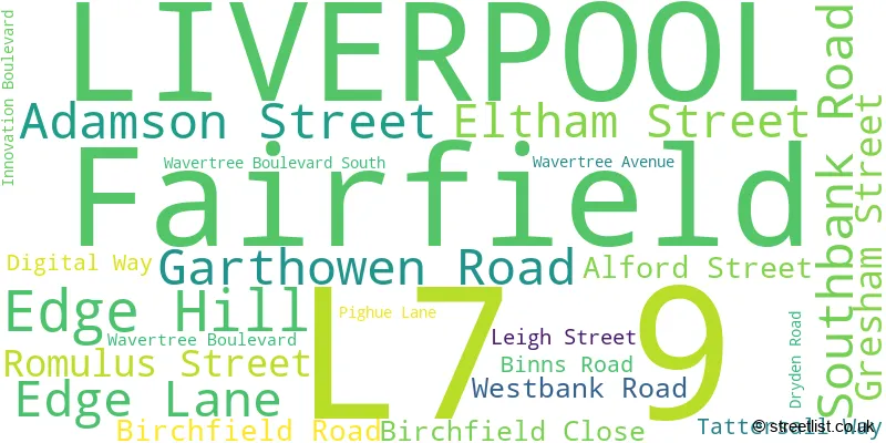
The largest settlement in the L7 9 postal code is LIVERPOOL followed by Fairfield, and Edge Hill.
The L7 9 Postcode shares a border with L7 6 (LIVERPOOL), L13 2 (LIVERPOOL, Old Swan, Stanley), L7 0 (LIVERPOOL, Fairfield), L7 5 (LIVERPOOL, Edge Hill), L7 2 (LIVERPOOL, Edge Hill), L13 1 (LIVERPOOL, Old Swan, Wavertree), L15 2 (LIVERPOOL, Wavertree) and L15 4 (LIVERPOOL, Wavertree).
The sector is within the post town of LIVERPOOL.
L7 9 is a postcode sector within the L7 postcode district which is within the L Liverpool postcode area.
The Royal Mail delivery office for the L7 9 postal sector is the Liverpool 6-7.
The area of the L7 9 postcode sector is 0.31 square miles which is 0.80 square kilometres or 197.65 square acres.

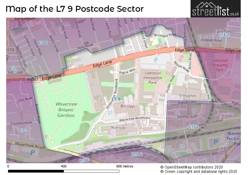
Map of the L7 9 Postcode Sector
Explore the L7 9 postcode sector by using our free interactive map.
| L | 7 | - | 9 | X | X |
| L | 7 | Space | 9 | Letter | Letter |
Official List of Streets
LIVERPOOL (17 Streets)
Edge Hill (2 Streets)
Unofficial Streets or Alternative Spellings
Liverpool Shopping Park
MONTROSE WAY CLYDE ROAD CRAWFORD WAY MILTON ROADLIVERPOOL
BEECH STREET BOTANIC PLACE BOTANIC ROAD BRADFIELD STREET CLINT ROAD CROSFIELD ROAD DEANE ROAD EDGE GROVE FAIRFIELD STREET GRAMPIAN ROAD LAUREL ROAD LOMOND ROAD WAVERTREE ROADWavertree
FARADAY ROADEdge Hill
EDGE LANEWeather Forecast for L7 9
Press Button to Show Forecast for Wavertree
| Time Period | Icon | Description | Temperature | Rain Probability | Wind |
|---|---|---|---|---|---|
| 18:00 to 21:00 | Sunny day | 8.0°C (feels like 6.0°C) | 0.00% | WNW 9 mph | |
| 21:00 to 00:00 | Clear night | 8.0°C (feels like 5.0°C) | 0.00% | NW 7 mph |
Press Button to Show Forecast for Wavertree
| Time Period | Icon | Description | Temperature | Rain Probability | Wind |
|---|---|---|---|---|---|
| 00:00 to 03:00 | Cloudy | 8.0°C (feels like 5.0°C) | 13.00% | NW 9 mph | |
| 03:00 to 06:00 | Light rain | 7.0°C (feels like 5.0°C) | 53.00% | WNW 9 mph | |
| 06:00 to 09:00 | Cloudy | 7.0°C (feels like 4.0°C) | 7.00% | NW 11 mph | |
| 09:00 to 12:00 | Cloudy | 8.0°C (feels like 5.0°C) | 12.00% | NW 11 mph | |
| 12:00 to 15:00 | Cloudy | 9.0°C (feels like 7.0°C) | 8.00% | NW 9 mph | |
| 15:00 to 18:00 | Cloudy | 9.0°C (feels like 7.0°C) | 13.00% | N 9 mph | |
| 18:00 to 21:00 | Light rain | 8.0°C (feels like 6.0°C) | 48.00% | N 7 mph | |
| 21:00 to 00:00 | Cloudy | 7.0°C (feels like 5.0°C) | 5.00% | ENE 7 mph |
Press Button to Show Forecast for Wavertree
| Time Period | Icon | Description | Temperature | Rain Probability | Wind |
|---|---|---|---|---|---|
| 00:00 to 03:00 | Partly cloudy (night) | 6.0°C (feels like 3.0°C) | 3.00% | E 7 mph | |
| 03:00 to 06:00 | Clear night | 4.0°C (feels like 2.0°C) | 2.00% | E 7 mph | |
| 06:00 to 09:00 | Sunny day | 4.0°C (feels like 2.0°C) | 1.00% | E 4 mph | |
| 09:00 to 12:00 | Partly cloudy (day) | 7.0°C (feels like 5.0°C) | 1.00% | E 4 mph | |
| 12:00 to 15:00 | Cloudy | 9.0°C (feels like 8.0°C) | 6.00% | NNE 4 mph | |
| 15:00 to 18:00 | Cloudy | 9.0°C (feels like 8.0°C) | 6.00% | N 4 mph | |
| 18:00 to 21:00 | Cloudy | 9.0°C (feels like 8.0°C) | 6.00% | NNE 7 mph | |
| 21:00 to 00:00 | Cloudy | 7.0°C (feels like 5.0°C) | 8.00% | NE 7 mph |
Press Button to Show Forecast for Wavertree
| Time Period | Icon | Description | Temperature | Rain Probability | Wind |
|---|---|---|---|---|---|
| 00:00 to 03:00 | Partly cloudy (night) | 5.0°C (feels like 3.0°C) | 6.00% | ESE 7 mph | |
| 03:00 to 06:00 | Partly cloudy (night) | 4.0°C (feels like 2.0°C) | 7.00% | ESE 7 mph | |
| 06:00 to 09:00 | Partly cloudy (day) | 4.0°C (feels like 2.0°C) | 5.00% | E 7 mph | |
| 09:00 to 12:00 | Partly cloudy (day) | 8.0°C (feels like 6.0°C) | 5.00% | ESE 7 mph | |
| 12:00 to 15:00 | Overcast | 10.0°C (feels like 8.0°C) | 14.00% | E 7 mph | |
| 15:00 to 18:00 | Light rain | 10.0°C (feels like 9.0°C) | 46.00% | NE 7 mph | |
| 18:00 to 21:00 | Cloudy | 10.0°C (feels like 8.0°C) | 15.00% | ENE 9 mph | |
| 21:00 to 00:00 | Partly cloudy (night) | 8.0°C (feels like 6.0°C) | 13.00% | NE 9 mph |
Press Button to Show Forecast for Wavertree
| Time Period | Icon | Description | Temperature | Rain Probability | Wind |
|---|---|---|---|---|---|
| 00:00 to 03:00 | Cloudy | 6.0°C (feels like 4.0°C) | 17.00% | NE 9 mph | |
| 03:00 to 06:00 | Cloudy | 6.0°C (feels like 3.0°C) | 16.00% | NNE 9 mph | |
| 06:00 to 09:00 | Light rain | 7.0°C (feels like 3.0°C) | 49.00% | NNE 11 mph | |
| 09:00 to 12:00 | Light rain | 8.0°C (feels like 5.0°C) | 49.00% | NNE 11 mph | |
| 12:00 to 15:00 | Light rain | 9.0°C (feels like 6.0°C) | 54.00% | N 11 mph | |
| 15:00 to 18:00 | Heavy rain | 10.0°C (feels like 7.0°C) | 73.00% | N 11 mph | |
| 18:00 to 21:00 | Partly cloudy (day) | 10.0°C (feels like 8.0°C) | 13.00% | NW 11 mph | |
| 21:00 to 00:00 | Clear night | 9.0°C (feels like 7.0°C) | 11.00% | WNW 9 mph |
Schools and Places of Education Within the L7 9 Postcode Sector
Phoenix Primary School
Community school
Birchfield Road, Liverpool, Merseyside, L7 9LY
Head: Mrs Terri Cheung
Ofsted Rating: Good
Inspection: 2022-06-15 (679 days ago)
Website: Visit Phoenix Primary School Website
Phone: 01512283831
Number of Pupils: 250
House Prices in the L7 9 Postcode Sector
| Type of Property | 2018 Average | 2018 Sales | 2017 Average | 2017 Sales | 2016 Average | 2016 Sales | 2015 Average | 2015 Sales |
|---|---|---|---|---|---|---|---|---|
| Detached | £0 | 0 | £0 | 0 | £0 | 0 | £0 | 0 |
| Semi-Detached | £94,000 | 3 | £0 | 0 | £0 | 0 | £87,500 | 2 |
| Terraced | £103,568 | 14 | £71,889 | 9 | £99,379 | 10 | £78,333 | 3 |
| Flats | £0 | 0 | £0 | 0 | £0 | 0 | £0 | 0 |
Important Postcodes L7 9 in the Postcode Sector
L7 9LY is the postcode for Phoenix Primary School, Birchfield Road, and PHOENIX PRIMARY SCHOOL, BIRCHFIELD ROAD, EDGE HILL
L7 9NJ is the postcode for ICDC, Faraday House
| The L7 9 Sector is within these Local Authorities |
|
|---|---|
| The L7 9 Sector is within these Counties |
|
| The L7 9 Sector is within these Water Company Areas |
|