The L9 postcode district is a postal district located in the L Liverpool postcode area with a population of 31,884 residents according to the 2021 England and Wales Census.
The area of the L9 postcode district is 3.28 square miles which is 8.49 square kilometres or 2,099.07 acres.
Currently, the L9 district has about 628 postcode units spread across 10 geographic postcode sectors.
Given that each sector allows for 400 unique postcode combinations, the district has a capacity of 4,000 postcodes. With 628 postcodes already in use, this leaves 3372 units available.
The largest settlement in the L9 postal code is LIVERPOOL followed by Walton, and Orrell Park.
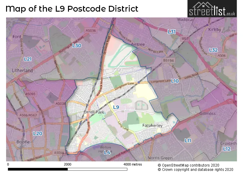
The L9 Postcode shares a border with L20 (BOOTLE, LIVERPOOL, Kirkdale), L10 (LIVERPOOL, Fazakerley, Aintree), L11 (LIVERPOOL, Norris Green, West Derby), L4 (LIVERPOOL, Walton, Anfield) and L30 (BOOTLE, Netherton).
The primary settlement in the L9 postcode district is Liverpool, which is located in the county of Merseyside in England. The most significant postal town in the district is Liverpool. Other significant settlements in the district include Aintree and Fazakerley.
For the district L9, we have data on 10 postcode sectors. Here's a breakdown: The sector L9 0, covers Liverpool and Walton in Merseyside. The sector L9 1, covers Liverpool and Walton in Merseyside. The sector L9 2, covers Liverpool and Walton in Merseyside. The sector L9 3, covers Liverpool in Merseyside. The sector L9 4, covers Liverpool and Walton in Merseyside. The sector L9 5, covers Liverpool and Aintree Racecourse Retail & Bus Pk in Merseyside. The sector L9 6, covers Liverpool and Walton in Merseyside. The sector L9 7, covers Liverpool and Walton in Merseyside. The sector L9 8, covers Liverpool and Orrell Park in Merseyside. The sector L9 9, covers Liverpool in Merseyside.

Map of the L9 Postcode District
Explore the L9 postcode district by using our free interactive map.
When it comes to local government, postal geography often disregards political borders. However, for a breakdown in the L9 District: the district mostly encompasses the Liverpool District (B) (602 postcodes), and finally, the Sefton District (B) area (28 postcodes).
Recent House Sales in L9
| Date | Price | Address |
|---|---|---|
| 27/10/2023 | £70,000 | Rice Lane, Liverpool, L9 1LS |
| 18/10/2023 | £83,000 | Bechers Row, Liverpool, L9 8EX |
| 16/10/2023 | £50,000 | Warbreck Moor, Liverpool, L9 0HX |
| 13/10/2023 | £60,000 | Guildhall Road, Liverpool, L9 4SJ |
| 29/09/2023 | £86,000 | Imison Street, Liverpool, L9 1EF |
| 20/09/2023 | £224,000 | Chapel Avenue, Liverpool, L9 2BY |
| 11/09/2023 | £102,000 | Sixth Avenue, Liverpool, L9 9DU |
| 08/09/2023 | £137,000 | Nelville Road, Liverpool, L9 9BR |
| 08/09/2023 | £165,000 | Highfield Road, Walton, Liverpool, L9 1AS |
| 08/09/2023 | £75,000 | Harbreck Grove, Liverpool, L9 6GB |
Weather Forecast for L9
Press Button to Show Forecast for Fazakerley
| Time Period | Icon | Description | Temperature | Rain Probability | Wind |
|---|---|---|---|---|---|
| 12:00 to 15:00 | Cloudy | 10.0°C (feels like 7.0°C) | 6.00% | NNW 9 mph | |
| 15:00 to 18:00 | Cloudy | 9.0°C (feels like 7.0°C) | 7.00% | N 9 mph | |
| 18:00 to 21:00 | Light rain | 8.0°C (feels like 6.0°C) | 47.00% | ENE 7 mph | |
| 21:00 to 00:00 | Cloudy | 7.0°C (feels like 5.0°C) | 5.00% | ENE 7 mph |
Press Button to Show Forecast for Fazakerley
| Time Period | Icon | Description | Temperature | Rain Probability | Wind |
|---|---|---|---|---|---|
| 00:00 to 03:00 | Partly cloudy (night) | 6.0°C (feels like 4.0°C) | 2.00% | E 7 mph | |
| 03:00 to 06:00 | Clear night | 4.0°C (feels like 2.0°C) | 2.00% | E 7 mph | |
| 06:00 to 09:00 | Sunny day | 4.0°C (feels like 2.0°C) | 2.00% | E 4 mph | |
| 09:00 to 12:00 | Cloudy | 7.0°C (feels like 5.0°C) | 6.00% | ESE 4 mph | |
| 12:00 to 15:00 | Cloudy | 9.0°C (feels like 8.0°C) | 6.00% | NNE 4 mph | |
| 15:00 to 18:00 | Cloudy | 10.0°C (feels like 8.0°C) | 6.00% | N 4 mph | |
| 18:00 to 21:00 | Partly cloudy (day) | 9.0°C (feels like 7.0°C) | 3.00% | NNE 7 mph | |
| 21:00 to 00:00 | Cloudy | 7.0°C (feels like 5.0°C) | 7.00% | NE 9 mph |
Press Button to Show Forecast for Fazakerley
| Time Period | Icon | Description | Temperature | Rain Probability | Wind |
|---|---|---|---|---|---|
| 00:00 to 03:00 | Partly cloudy (night) | 6.0°C (feels like 3.0°C) | 4.00% | ESE 9 mph | |
| 03:00 to 06:00 | Partly cloudy (night) | 4.0°C (feels like 2.0°C) | 5.00% | ESE 7 mph | |
| 06:00 to 09:00 | Partly cloudy (day) | 5.0°C (feels like 2.0°C) | 4.00% | E 7 mph | |
| 09:00 to 12:00 | Cloudy | 8.0°C (feels like 6.0°C) | 8.00% | ESE 7 mph | |
| 12:00 to 15:00 | Overcast | 10.0°C (feels like 9.0°C) | 12.00% | E 7 mph | |
| 15:00 to 18:00 | Overcast | 10.0°C (feels like 9.0°C) | 18.00% | NE 7 mph | |
| 18:00 to 21:00 | Cloudy | 10.0°C (feels like 8.0°C) | 14.00% | ENE 9 mph | |
| 21:00 to 00:00 | Cloudy | 8.0°C (feels like 6.0°C) | 13.00% | NE 9 mph |
Press Button to Show Forecast for Fazakerley
| Time Period | Icon | Description | Temperature | Rain Probability | Wind |
|---|---|---|---|---|---|
| 00:00 to 03:00 | Light rain | 6.0°C (feels like 4.0°C) | 45.00% | NE 9 mph | |
| 03:00 to 06:00 | Cloudy | 6.0°C (feels like 3.0°C) | 15.00% | NNE 11 mph | |
| 06:00 to 09:00 | Light rain | 7.0°C (feels like 4.0°C) | 48.00% | NNE 11 mph | |
| 09:00 to 12:00 | Cloudy | 8.0°C (feels like 5.0°C) | 20.00% | NNE 11 mph | |
| 12:00 to 15:00 | Light rain | 9.0°C (feels like 6.0°C) | 53.00% | N 11 mph | |
| 15:00 to 18:00 | Heavy rain | 10.0°C (feels like 7.0°C) | 69.00% | N 11 mph | |
| 18:00 to 21:00 | Partly cloudy (day) | 10.0°C (feels like 8.0°C) | 14.00% | NNW 13 mph | |
| 21:00 to 00:00 | Partly cloudy (night) | 9.0°C (feels like 7.0°C) | 9.00% | WNW 9 mph |
Where is the L9 Postcode District?
The postcode district L9 is located in Liverpool. It is situated near the towns of Bootle to the west, Wallasey to the south west, Prescot to the south east, Ormskirk to the north east, and St. Helens to the east. The distance between L9 and the center of London is approximately 180.08 miles.
The district is within the post town of LIVERPOOL.
The sector has postcodes within the nation of England.
The L9 Postcode District is covers the following regions.
- Liverpool - Merseyside - North West (England)
- Sefton - Merseyside - North West (England)
| Postcode Sector | Delivery Office |
|---|---|
| L9 0 | Walton (l) Delivery Office |
| L9 1 | Walton (l) Delivery Office |
| L9 2 | Walton (l) Delivery Office |
| L9 3 | Walton (l) Delivery Office |
| L9 4 | Walton (l) Delivery Office |
| L9 5 | Walton (l) Delivery Office |
| L9 6 | Walton (l) Delivery Office |
| L9 7 | Walton (l) Delivery Office |
| L9 8 | Walton (l) Delivery Office |
| L9 9 | Walton (l) Delivery Office |
| L | 9 | - | X | X | X |
| L | 9 | Space | Numeric | Letter | Letter |
Current Monthly Rental Prices
| # Bedrooms | Min Price | Max Price | Avg Price |
|---|---|---|---|
| £330 | £330 | £330 | |
| 1 | £425 | £823 | £636 |
| 2 | £550 | £750 | £675 |
| 3 | £850 | £995 | £913 |
| 5 | £1,200 | £1,200 | £1,200 |
Current House Prices
| # Bedrooms | Min Price | Max Price | Avg Price |
|---|---|---|---|
| £160,000 | £550,000 | £345,000 | |
| 1 | £45,000 | £79,950 | £64,238 |
| 2 | £45,000 | £140,000 | £99,996 |
| 3 | £75,000 | £270,000 | £153,564 |
| 4 | £140,000 | £550,000 | £227,647 |
| 5 | £200,000 | £335,000 | £278,000 |
| 6 | £190,000 | £250,000 | £226,667 |
| 7 | £310,000 | £310,000 | £310,000 |
| 9 | £220,000 | £220,000 | £220,000 |
Estate Agents who Operate in the L9 District
| Logo | Name | Brand Name | Address | Contact Number | Total Properties |
|---|---|---|---|---|---|
 | Walton Vale | Entwistle Green | 51 Walton Vale, Liverpool, L9 4RF | 0151 453 2738 | 21 |
 | Walton Vale, Liverpool | Whitegates | 498 Rice Lane Walton Vale Liverpool L9 2BW | 0151 453 8569 | 20 |
 | Liverpool | Strike | Nationwide | 0151 453 3496 | 11 |
 | covering Liverpool | Purplebricks | Suite 7 First Floor Cranmore Drive Shirley Solihull B90 4RZ | 020 3907 2647 | 10 |
 | Aintree | Grosvenor Waterford Estate Agents | 197 Altway, Aintree, Liverpool, L10 6LB | 0151 453 1251 | 10 |
| Type of Property | 2018 Average | 2018 Sales | 2017 Average | 2017 Sales | 2016 Average | 2016 Sales | 2015 Average | 2015 Sales |
|---|---|---|---|---|---|---|---|---|
| Detached | £201,161 | 64 | £188,847 | 43 | £173,266 | 72 | £161,888 | 41 |
| Semi-Detached | £131,131 | 115 | £126,545 | 145 | £133,360 | 171 | £108,803 | 115 |
| Terraced | £85,668 | 260 | £85,186 | 224 | £81,138 | 232 | £82,610 | 197 |
| Flats | £69,361 | 36 | £57,609 | 22 | £56,577 | 30 | £57,015 | 20 |