The LA12 0 postcode sector is within the county of Cumbria.
Did you know? According to the 2021 Census, the LA12 0 postcode sector is home to a bustling 6,066 residents!
Given that each sector allows for 400 unique postcode combinations. Letters C, I, K, M, O and V are not allowed in the last two letters of a postcode. With 262 postcodes already in use, this leaves 138 units available.
The largest settlement in the LA12 0 postal code is ULVERSTON followed by Swarthmoor, and Lindal.
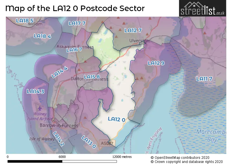
The LA12 0 Postcode shares a border with LA12 9 (ULVERSTON, Bardsea, Baycliff), LA13 0 (BARROW-IN-FURNESS, Newton In Furness, Stainton With Adgarley), LA12 7 (ULVERSTON, Penny Bridge, Greenodd), LA16 7 (ASKAM-IN-FURNESS), LA17 7 (KIRKBY-IN-FURNESS, Grizebeck, Soutergate) and LA15 8 (DALTON-IN-FURNESS).
The sector is within the post town of ULVERSTON.
LA12 0 is a postcode sector within the LA12 postcode district which is within the LA Lancaster postcode area.
The Royal Mail delivery office for the LA12 0 postal sector is the Ulverston Delivery Office.
The area of the LA12 0 postcode sector is 14.16 square miles which is 36.67 square kilometres or 9,060.46 square acres.
The LA12 0 postcode sector is crossed by the A590 Major A road.

Map of the LA12 0 Postcode Sector
Explore the LA12 0 postcode sector by using our free interactive map.
| L | A | 1 | 2 | - | 0 | X | X |
| L | A | 1 | 2 | Space | 0 | Letter | Letter |
Official List of Streets
ULVERSTON (53 Streets)
Lindal (16 Streets)
Scales (3 Streets)
Swarthmoor (23 Streets)
Little Urswick (4 Streets)
Great Urswick (7 Streets)
Roosebeck (1 Streets)
Gleaston (6 Streets)
Marton (5 Streets)
Leece (2 Streets)
Pennington (3 Streets)
Wood Head (1 Streets)
Newbiggin (4 Streets)
Dragley Beck (1 Streets)
Unofficial Streets or Alternative Spellings
ULVERSTON
BIRKETT DRIVE DEVONSHIRE ROAD PRIORY ROAD QUEBEC STREET SYCAMORE AVENUE URSWICK ROAD ASH TREE COURT BRACKEN BED LANE BRAKEN BEDS LANE CARRS LANE CHURCH HILL COUNTY ROAD DIMPLES HOLE LANE HALIER HOW LANE HARD KNOTTS LANE HEN PARROCK LANE HOOK LANE KILN LANE LONG LANE LYNDHURST PARK MALKINS BANK MEADOW LANE MELTON BROW MIDDLE BARROW LANE MILL LANE MOSS LANE PRINCES STREET RED SYKE BRIDGE RIDDINGS LANE SEG LANE STAINTON LANE STONE BARROW LANE STONE DIKE LANE SUNNY BANK SWARTHMOOR HALL LANE VICTORIA STREET WHITE GILL LANESwarthmoor
CROSS-A-MOORBardsea
COAST ROADDALTON-IN-FURNESS
URSWICK ROADStank
STANK LANEStainton With Adgarley
LONG LANENewton In Furness
GREYSTONE LANEBARROW-IN-FURNESS
DUNGEON LANERoose
LEECE LANEWeather Forecast for LA12 0
Press Button to Show Forecast for Dalton-In-Furness
| Time Period | Icon | Description | Temperature | Rain Probability | Wind |
|---|---|---|---|---|---|
| 21:00 to 00:00 | Partly cloudy (night) | 5.0°C (feels like 3.0°C) | 1.00% | ENE 7 mph |
Press Button to Show Forecast for Dalton-In-Furness
| Time Period | Icon | Description | Temperature | Rain Probability | Wind |
|---|---|---|---|---|---|
| 00:00 to 03:00 | Clear night | 4.0°C (feels like 1.0°C) | 1.00% | ENE 7 mph | |
| 03:00 to 06:00 | Clear night | 2.0°C (feels like 0.0°C) | 1.00% | ENE 7 mph | |
| 06:00 to 09:00 | Sunny day | 3.0°C (feels like 1.0°C) | 1.00% | ENE 4 mph | |
| 09:00 to 12:00 | Partly cloudy (day) | 7.0°C (feels like 6.0°C) | 1.00% | ENE 4 mph | |
| 12:00 to 15:00 | Cloudy | 8.0°C (feels like 7.0°C) | 12.00% | N 4 mph | |
| 15:00 to 18:00 | Light rain shower (day) | 9.0°C (feels like 8.0°C) | 31.00% | WSW 4 mph | |
| 18:00 to 21:00 | Partly cloudy (day) | 8.0°C (feels like 7.0°C) | 7.00% | N 4 mph | |
| 21:00 to 00:00 | Clear night | 5.0°C (feels like 4.0°C) | 2.00% | NNE 4 mph |
Press Button to Show Forecast for Dalton-In-Furness
| Time Period | Icon | Description | Temperature | Rain Probability | Wind |
|---|---|---|---|---|---|
| 00:00 to 03:00 | Clear night | 4.0°C (feels like 1.0°C) | 3.00% | ENE 7 mph | |
| 03:00 to 06:00 | Partly cloudy (night) | 3.0°C (feels like 1.0°C) | 3.00% | ENE 4 mph | |
| 06:00 to 09:00 | Sunny day | 4.0°C (feels like 2.0°C) | 4.00% | ENE 4 mph | |
| 09:00 to 12:00 | Partly cloudy (day) | 8.0°C (feels like 7.0°C) | 7.00% | E 7 mph | |
| 12:00 to 15:00 | Overcast | 10.0°C (feels like 9.0°C) | 14.00% | ESE 7 mph | |
| 15:00 to 18:00 | Cloudy | 10.0°C (feels like 9.0°C) | 12.00% | NE 4 mph | |
| 18:00 to 21:00 | Cloudy | 10.0°C (feels like 9.0°C) | 10.00% | ENE 7 mph | |
| 21:00 to 00:00 | Cloudy | 7.0°C (feels like 5.0°C) | 10.00% | NE 7 mph |
Press Button to Show Forecast for Dalton-In-Furness
| Time Period | Icon | Description | Temperature | Rain Probability | Wind |
|---|---|---|---|---|---|
| 00:00 to 03:00 | Cloudy | 5.0°C (feels like 3.0°C) | 13.00% | NE 7 mph | |
| 03:00 to 06:00 | Partly cloudy (night) | 5.0°C (feels like 2.0°C) | 11.00% | NNE 7 mph | |
| 06:00 to 09:00 | Cloudy | 6.0°C (feels like 4.0°C) | 14.00% | NNE 7 mph | |
| 09:00 to 12:00 | Cloudy | 9.0°C (feels like 7.0°C) | 17.00% | NNE 9 mph | |
| 12:00 to 15:00 | Cloudy | 11.0°C (feels like 9.0°C) | 15.00% | NNE 9 mph | |
| 15:00 to 18:00 | Cloudy | 11.0°C (feels like 9.0°C) | 18.00% | NW 11 mph | |
| 18:00 to 21:00 | Sunny day | 10.0°C (feels like 8.0°C) | 12.00% | NNW 11 mph | |
| 21:00 to 00:00 | Clear night | 8.0°C (feels like 5.0°C) | 8.00% | NNW 9 mph |
Schools and Places of Education Within the LA12 0 Postcode Sector
Low Furness CofE Primary School
Voluntary controlled school
Church Road, Ulverston, Cumbria, LA12 0TA
Head: Mrs Sue Little
Ofsted Rating: Good
Inspection: 2019-06-13 (1778 days ago)
Website: Visit Low Furness CofE Primary School Website
Phone: 01229588708
Number of Pupils: 143
Pennington CofE School
Voluntary controlled school
Pennington, Ulverston, Cumbria, LA12 0RR
Head: Mrs Helen Storey
Ofsted Rating: Good
Inspection: 2020-03-11 (1506 days ago)
Website: Visit Pennington CofE School Website
Phone: 01229587253
Number of Pupils: 196
Sandside Lodge School
Community special school
Springfield Road, Ulverston, Cumbria, LA12 0DZ
Head: Miss Helen Grice
Ofsted Rating: Good
Inspection: 2017-09-12 (2417 days ago)
Website: Visit Sandside Lodge School Website
Phone: 01229588825
Number of Pupils: 84
Sir John Barrow School
Community school
Argyle Street, Ulverston, Cumbria, LA12 0BD
Head: Mrs Helen Pearson
Ofsted Rating: Outstanding
Inspection: 2023-03-02 (420 days ago)
Website: Visit Sir John Barrow School Website
Phone: 01229483960
Number of Pupils: 223
Ulverston Victoria High School
Community school
Springfield Road, Ulverston, Cumbria, LA12 0EB
Head: Mr Matthew Hardwick
Ofsted Rating: Good
Inspection: 2023-09-21 (217 days ago)
Website: Visit Ulverston Victoria High School Website
Phone: 01229483900
Number of Pupils: 1339
House Prices in the LA12 0 Postcode Sector
| Type of Property | 2018 Average | 2018 Sales | 2017 Average | 2017 Sales | 2016 Average | 2016 Sales | 2015 Average | 2015 Sales |
|---|---|---|---|---|---|---|---|---|
| Detached | £318,927 | 39 | £299,328 | 39 | £289,297 | 34 | £275,080 | 36 |
| Semi-Detached | £224,338 | 28 | £220,038 | 35 | £189,962 | 13 | £178,914 | 25 |
| Terraced | £170,357 | 49 | £169,751 | 38 | £162,264 | 62 | £156,276 | 48 |
| Flats | £123,200 | 7 | £136,750 | 2 | £109,400 | 5 | £112,250 | 4 |
Important Postcodes LA12 0 in the Postcode Sector
LA12 0BD is the postcode for Sir John Barrow School, Argyle Street
LA12 0BT is the postcode for Public Library, Kings Road
LA12 0EA is the postcode for St. Marys Catholic Primary School, Springfield Road
LA12 0EB is the postcode for DT, ART AND SPORTS, Ulverston Victoria High School, Springfield Road, CENTRE AND TOWNSLAND, Ulverston Victoria High School, Springfield Road, MAIN BLOCK, Ulverston Victoria High School, Springfield Road, SOUTH BLOCK, Ulverston Victoria High School, Springfield Road, Ulverston Victoria High School, Springfield Road, SPORTS BLOCK ULVERSTON VICTORIA HIGH SCHOOL, Ulverston Victoria High School, Springfield Road, GYMNASIUM, Ulverston Victoria High School, Springfield Road, NORTH BLOCK, Ulverston Victoria High School, Springfield Road, and A BLOCK ULVERSTON VICTORIA HIGH SCHOOL, Ulverston Victoria High School, Springfield Road
LA12 0ER is the postcode for Cumbria County Council, Marsh House, Victoria Road, and Marsh House EPH, Victoria Road
| The LA12 0 Sector is within these Local Authorities |
|
|---|---|
| The LA12 0 Sector is within these Counties |
|
| The LA12 0 Sector is within these Water Company Areas |
|