The LA2 6 postcode sector is within the county of Lancashire.
Did you know? According to the 2021 Census, the LA2 6 postcode sector is home to a bustling 5,794 residents!
Given that each sector allows for 400 unique postcode combinations. Letters C, I, K, M, O and V are not allowed in the last two letters of a postcode. With 208 postcodes already in use, this leaves 192 units available.
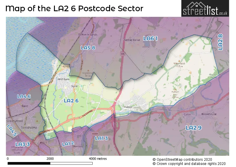
The largest settlement in the LA2 6 postal code is Halton followed by Hest Bank, and Slyne.
The LA2 6 Postcode shares a border with LA1 2 (LANCASTER), LA1 3 (LANCASTER, Lansil Industrial Estate), LA2 8 (Clapham, Austwick, Hornby), LA2 9 (Caton, Brookhouse, Dolphinholme), LA4 6 (MORECAMBE), LA5 8 (Bolton Le Sands, Nether Kellet) and LA6 1 (Holme, Burton, Nether Kellet).
The sector is within the post town of LANCASTER.
LA2 6 is a postcode sector within the LA2 postcode district which is within the LA Lancaster postcode area.
The Royal Mail delivery office for the LA2 6 postal sector is the Lancaster Delivery Office.
The area of the LA2 6 postcode sector is 7.42 square miles which is 19.22 square kilometres or 4,748.90 square acres.
The LA2 6 postcode sector is crossed by the M6 motorway.
Waterways within the LA2 6 postcode sector include the River Lune, Lancaster Canal.

Map of the LA2 6 Postcode Sector
Explore the LA2 6 postcode sector by using our free interactive map.
| L | A | 2 | - | 6 | X | X |
| L | A | 2 | Space | 6 | Letter | Letter |
Official List of Streets
Halton (47 Streets)
Slyne (35 Streets)
Hest Bank (37 Streets)
LANCASTER (2 Streets)
Unofficial Streets or Alternative Spellings
Halton
VICTORIA PLACE AUGHTON ROAD BAY GATEWAY BLIND LANE BRIDGE CHURCH STREET CLOU GHA AVENUE CROSS BAY WALK DENNY BECK LANE FOLLY BRIDGE FOLLY ROAD GREEN HILL LANE GREEN LANE GROVE COURT HAMMERTON HALL LANE LAVERICK ROAD LITTLEDALE MEWS LUNE VIEW LUNE VIEW PARK OCCUPATION BRIDGE PARK LANE POWDER HOUSE LANE RAILWAY FOOTBRIDGE RAKES HEAD BRIDGE RUSHLEY WAY SHEFFERLANDS ROUNDABOUT TOWNFIELD LANE WILLIAMLANDS BRIDGEBolton Le Sands
ANCLIFFE LANE COASTAL ROAD MADISON AVENUE SLYNE ROADLANCASTER
BARLEY COP LANE HALTON ROADMORECAMBE
SLYNE ROADNether Kellet
DUNALD MILL LANE SCARGILL ROADCrook O Lune
LOW ROADWeather Forecast for LA2 6
Press Button to Show Forecast for Carnforth
| Time Period | Icon | Description | Temperature | Rain Probability | Wind |
|---|---|---|---|---|---|
| 09:00 to 12:00 | Cloudy | 8.0°C (feels like 6.0°C) | 5.00% | N 9 mph | |
| 12:00 to 15:00 | Cloudy | 9.0°C (feels like 8.0°C) | 5.00% | N 7 mph | |
| 15:00 to 18:00 | Cloudy | 10.0°C (feels like 8.0°C) | 6.00% | N 7 mph | |
| 18:00 to 21:00 | Cloudy | 8.0°C (feels like 6.0°C) | 5.00% | ENE 7 mph | |
| 21:00 to 00:00 | Clear night | 5.0°C (feels like 4.0°C) | 3.00% | ENE 4 mph |
Press Button to Show Forecast for Carnforth
| Time Period | Icon | Description | Temperature | Rain Probability | Wind |
|---|---|---|---|---|---|
| 00:00 to 03:00 | Clear night | 3.0°C (feels like 0.0°C) | 1.00% | ENE 4 mph | |
| 03:00 to 06:00 | Clear night | 1.0°C (feels like -1.0°C) | 1.00% | ENE 4 mph | |
| 06:00 to 09:00 | Sunny day | 2.0°C (feels like 1.0°C) | 1.00% | ENE 4 mph | |
| 09:00 to 12:00 | Cloudy | 7.0°C (feels like 6.0°C) | 5.00% | NE 4 mph | |
| 12:00 to 15:00 | Overcast | 9.0°C (feels like 8.0°C) | 11.00% | NE 4 mph | |
| 15:00 to 18:00 | Overcast | 9.0°C (feels like 8.0°C) | 11.00% | N 4 mph | |
| 18:00 to 21:00 | Cloudy | 8.0°C (feels like 7.0°C) | 8.00% | NNE 4 mph | |
| 21:00 to 00:00 | Partly cloudy (night) | 5.0°C (feels like 3.0°C) | 2.00% | ENE 4 mph |
Press Button to Show Forecast for Carnforth
| Time Period | Icon | Description | Temperature | Rain Probability | Wind |
|---|---|---|---|---|---|
| 00:00 to 03:00 | Partly cloudy (night) | 4.0°C (feels like 1.0°C) | 2.00% | E 4 mph | |
| 03:00 to 06:00 | Partly cloudy (night) | 2.0°C (feels like 0.0°C) | 3.00% | E 4 mph | |
| 06:00 to 09:00 | Partly cloudy (day) | 4.0°C (feels like 2.0°C) | 3.00% | E 4 mph | |
| 09:00 to 12:00 | Partly cloudy (day) | 8.0°C (feels like 6.0°C) | 6.00% | E 7 mph | |
| 12:00 to 15:00 | Cloudy | 10.0°C (feels like 8.0°C) | 9.00% | E 7 mph | |
| 15:00 to 18:00 | Cloudy | 10.0°C (feels like 9.0°C) | 14.00% | E 7 mph | |
| 18:00 to 21:00 | Cloudy | 9.0°C (feels like 7.0°C) | 11.00% | E 9 mph | |
| 21:00 to 00:00 | Partly cloudy (night) | 6.0°C (feels like 4.0°C) | 9.00% | ENE 7 mph |
Press Button to Show Forecast for Carnforth
| Time Period | Icon | Description | Temperature | Rain Probability | Wind |
|---|---|---|---|---|---|
| 00:00 to 03:00 | Cloudy | 5.0°C (feels like 2.0°C) | 13.00% | NE 7 mph | |
| 03:00 to 06:00 | Cloudy | 5.0°C (feels like 2.0°C) | 11.00% | NNE 9 mph | |
| 06:00 to 09:00 | Cloudy | 6.0°C (feels like 3.0°C) | 15.00% | NNE 9 mph | |
| 09:00 to 12:00 | Cloudy | 8.0°C (feels like 5.0°C) | 20.00% | NE 9 mph | |
| 12:00 to 15:00 | Light rain | 9.0°C (feels like 7.0°C) | 46.00% | NNE 11 mph | |
| 15:00 to 18:00 | Heavy rain shower (day) | 10.0°C (feels like 8.0°C) | 57.00% | N 9 mph | |
| 18:00 to 21:00 | Light rain shower (day) | 10.0°C (feels like 8.0°C) | 39.00% | NNW 9 mph | |
| 21:00 to 00:00 | Partly cloudy (night) | 8.0°C (feels like 5.0°C) | 10.00% | WNW 9 mph |
Schools and Places of Education Within the LA2 6 Postcode Sector
Beaumont College - A Salutem/Ambito College
Special post 16 institution
Slyne Road, Lancaster, , LA2 6AP
Head: Principal Angela Johnson
Ofsted Rating: Good
Inspection: 2022-11-23 (519 days ago)
Website: Visit Beaumont College - A Salutem/Ambito College Website
Phone: 01524541400
Number of Pupils: 0
Slyne-with-Hest, St Luke's, Church of England Primary School
Voluntary aided school
Shady Lane, Lancaster, Lancashire, LA2 6JL
Head: Mr Paul Bowden
Ofsted Rating: Good
Inspection: 2022-01-12 (834 days ago)
Website: Visit Slyne-with-Hest, St Luke's, Church of England Primary School Website
Phone: 01524823505
Number of Pupils: 218
St Wilfrid's Cof E Primary School
Voluntary aided school
Pennystone Road, Lancaster, Lancashire, LA2 6QE
Head: Mr Mark Curwen
Ofsted Rating: Good
Inspection: 2020-01-16 (1561 days ago)
Website: Visit St Wilfrid's Cof E Primary School Website
Phone: 01524811230
Number of Pupils: 231
House Prices in the LA2 6 Postcode Sector
| Type of Property | 2018 Average | 2018 Sales | 2017 Average | 2017 Sales | 2016 Average | 2016 Sales | 2015 Average | 2015 Sales |
|---|---|---|---|---|---|---|---|---|
| Detached | £332,766 | 47 | £322,105 | 52 | £302,518 | 53 | £299,878 | 37 |
| Semi-Detached | £211,093 | 23 | £204,293 | 35 | £205,701 | 41 | £187,005 | 38 |
| Terraced | £192,650 | 10 | £187,089 | 18 | £233,029 | 17 | £230,970 | 17 |
| Flats | £117,400 | 5 | £144,733 | 6 | £134,000 | 7 | £115,346 | 13 |
Important Postcodes LA2 6 in the Postcode Sector
LA2 6AP is the postcode for Beaumont College, Slyne Road
LA2 6JL is the postcode for Slyne With Hest C of E School, Shady Lane
LA2 6QE is the postcode for St. Wilfreds C of E Primary School, Penny Stone Road
| The LA2 6 Sector is within these Local Authorities |
|
|---|---|
| The LA2 6 Sector is within these Counties |
|
| The LA2 6 Sector is within these Water Company Areas |
|