The LA20 postcode district is a postal district located in the LA Lancaster postcode area with a population of 1,191 residents according to the 2021 England and Wales Census.
The area of the LA20 postcode district is 52.01 square miles which is 134.70 square kilometres or 33,286.06 acres.
Currently, the LA20 district has about 87 postcode units spread across 1 geographic postcode sectors.
Given that each sector allows for 400 unique postcode combinations, the district has a capacity of 400 postcodes. With 87 postcodes already in use, this leaves 313 units available.
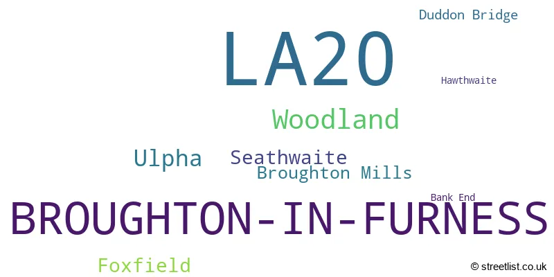
The largest settlement in the LA20 postal code is BROUGHTON-IN-FURNESS followed by Ulpha, and Seathwaite.
The postcode area has a boundary with The Irish Sea.
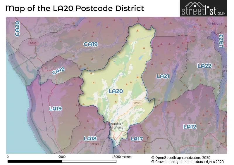
The LA20 Postcode shares a border with LA21 (CONISTON, Torver, Haws Bank), LA22 (AMBLESIDE, Grasmere, Hawkshead), LA18 (MILLOM, Haverigg, Silecroft), LA17 (KIRKBY-IN-FURNESS, Grizebeck, Soutergate), LA19 (Bootle, Bootle Station, Waberthwaite) and CA19 (Drigg, Eskdale, HOLMROOK).
In the LA20 postcode district in Cumbria, the primary settlement is Broughton-in-Furness. Other significant settlements in the district include Bank End, Broughton Mills, Duddon Bridge, Foxfield, Hawthwaite, Seathwaite, Ulpha, and Woodland. The most significant Postal Town in the district is Broughton-in-Furness.
For the district LA20, we have data on 1 postcode sectors. Here's a breakdown: The sector LA20 6, covers Broughton-In-Furness and Woodland in Cumbria.
LA20 Postcode Sectors

Map of the LA20 Postcode District
Explore the LA20 postcode district by using our free interactive map.
When it comes to local government, postal geography often disregards political borders. However, for a breakdown in the LA20 District: the district mostly encompasses the Westmorland and Furness (78 postcodes), and finally, the Cumberland area (10 postcodes).
Recent House Sales in LA20
| Date | Price | Address |
|---|---|---|
| 05/09/2023 | £800,000 | Broughton-in-furness, LA20 6BA |
| 23/08/2023 | £610,000 | Church Street, Broughton-in-furness, LA20 6HJ |
| 21/07/2023 | £180,000 | Foxfield, Broughton-in-furness, LA20 6BT |
| 03/07/2023 | £325,000 | The Square, Broughton-in-furness, LA20 6JA |
| 09/05/2023 | £252,500 | Duddon Mews, Foxfield, Broughton-in-furness, LA20 6BE |
| 05/05/2023 | £340,000 | Copper Rigg, Broughton-in-furness, LA20 6AJ |
| 28/04/2023 | £335,000 | Foxfield Road, Broughton-in-furness, LA20 6EZ |
| 06/04/2023 | £500,000 | Broughton-in-furness, LA20 6DS |
| 05/04/2023 | £150,000 | Foxfield, Broughton-in-furness, LA20 6BX |
| 04/04/2023 | £560,000 | Broughton-in-furness, LA20 6BP |
Weather Forecast for LA20
Press Button to Show Forecast for Broughton Mills
| Time Period | Icon | Description | Temperature | Rain Probability | Wind |
|---|---|---|---|---|---|
| 09:00 to 12:00 | Sunny day | 7.0°C (feels like 6.0°C) | 0.00% | NNE 7 mph | |
| 12:00 to 15:00 | Partly cloudy (day) | 10.0°C (feels like 8.0°C) | 1.00% | N 7 mph | |
| 15:00 to 18:00 | Partly cloudy (day) | 10.0°C (feels like 8.0°C) | 1.00% | NW 9 mph | |
| 18:00 to 21:00 | Sunny day | 9.0°C (feels like 7.0°C) | 0.00% | NW 9 mph | |
| 21:00 to 00:00 | Cloudy | 6.0°C (feels like 5.0°C) | 4.00% | WNW 4 mph |
Press Button to Show Forecast for Broughton Mills
| Time Period | Icon | Description | Temperature | Rain Probability | Wind |
|---|---|---|---|---|---|
| 00:00 to 03:00 | Partly cloudy (night) | 6.0°C (feels like 3.0°C) | 1.00% | WNW 7 mph | |
| 03:00 to 06:00 | Cloudy | 5.0°C (feels like 3.0°C) | 13.00% | NW 7 mph | |
| 06:00 to 09:00 | Cloudy | 6.0°C (feels like 4.0°C) | 17.00% | NW 7 mph | |
| 09:00 to 12:00 | Partly cloudy (day) | 9.0°C (feels like 6.0°C) | 4.00% | NNW 9 mph | |
| 12:00 to 15:00 | Overcast | 9.0°C (feels like 8.0°C) | 10.00% | NNW 9 mph | |
| 15:00 to 18:00 | Cloudy | 10.0°C (feels like 8.0°C) | 10.00% | NNW 7 mph | |
| 18:00 to 21:00 | Cloudy | 9.0°C (feels like 7.0°C) | 6.00% | NNE 7 mph | |
| 21:00 to 00:00 | Cloudy | 6.0°C (feels like 4.0°C) | 7.00% | ENE 4 mph |
Press Button to Show Forecast for Broughton Mills
| Time Period | Icon | Description | Temperature | Rain Probability | Wind |
|---|---|---|---|---|---|
| 00:00 to 03:00 | Cloudy | 4.0°C (feels like 2.0°C) | 7.00% | ENE 4 mph | |
| 03:00 to 06:00 | Cloudy | 3.0°C (feels like 1.0°C) | 10.00% | ENE 4 mph | |
| 06:00 to 09:00 | Cloudy | 4.0°C (feels like 2.0°C) | 10.00% | ENE 4 mph | |
| 09:00 to 12:00 | Cloudy | 7.0°C (feels like 5.0°C) | 11.00% | E 7 mph | |
| 12:00 to 15:00 | Light rain | 9.0°C (feels like 7.0°C) | 43.00% | SE 7 mph | |
| 15:00 to 18:00 | Cloudy | 9.0°C (feels like 8.0°C) | 15.00% | SE 7 mph | |
| 18:00 to 21:00 | Cloudy | 9.0°C (feels like 7.0°C) | 12.00% | E 7 mph | |
| 21:00 to 00:00 | Cloudy | 7.0°C (feels like 5.0°C) | 10.00% | ENE 7 mph |
Press Button to Show Forecast for Broughton Mills
| Time Period | Icon | Description | Temperature | Rain Probability | Wind |
|---|---|---|---|---|---|
| 00:00 to 03:00 | Cloudy | 6.0°C (feels like 3.0°C) | 11.00% | E 7 mph | |
| 03:00 to 06:00 | Cloudy | 5.0°C (feels like 2.0°C) | 13.00% | ENE 7 mph | |
| 06:00 to 09:00 | Overcast | 6.0°C (feels like 3.0°C) | 16.00% | ENE 7 mph | |
| 09:00 to 12:00 | Cloudy | 8.0°C (feels like 6.0°C) | 18.00% | E 9 mph | |
| 12:00 to 15:00 | Overcast | 10.0°C (feels like 8.0°C) | 20.00% | E 11 mph | |
| 15:00 to 18:00 | Cloudy | 11.0°C (feels like 9.0°C) | 21.00% | E 9 mph | |
| 18:00 to 21:00 | Cloudy | 10.0°C (feels like 8.0°C) | 12.00% | ENE 9 mph | |
| 21:00 to 00:00 | Cloudy | 7.0°C (feels like 5.0°C) | 11.00% | ENE 9 mph |
Where is the LA20 Postcode District?
The postcode district LA20 is located in Broughton-in-Furness. This district is in close proximity to several nearby towns: Coniston is located to the east, Kirkby-in-Furness is to the south, Ravenglass is to the west, Ulverston is to the southeast, and Ambleside is to the northeast. Additionally, Broughton-in-Furness is approximately 233.95 miles away from the center of London.
The district is within the post town of BROUGHTON-IN-FURNESS.
The sector has postcodes within the nation of England.
The LA20 Postcode District is covers the following regions.
- East Cumbria - Cumbria - North West (England)
- West Cumbria - Cumbria - North West (England)
Postcode Sectors within the LA20 District
| Postcode Sector | Delivery Office |
|---|---|
| LA20 6 | Broughton-in-furness Scale Payment Delivery Office |
| L | A | 2 | 0 | - | X | X | X |
| L | A | 2 | 0 | Space | Numeric | Letter | Letter |
Current Monthly Rental Prices
| # Bedrooms | Min Price | Max Price | Avg Price |
|---|---|---|---|
| 6 | £1,500 | £1,500 | £1,500 |
Current House Prices
| # Bedrooms | Min Price | Max Price | Avg Price |
|---|---|---|---|
| 1 | £185,000 | £185,000 | £185,000 |
| 2 | £349,000 | £375,000 | £362,000 |
| 3 | £535,000 | £535,000 | £535,000 |
| 4 | £250,000 | £585,000 | £416,000 |
| 5 | £570,000 | £570,000 | £570,000 |
| 6 | £749,000 | £749,000 | £749,000 |
Estate Agents who Operate in the LA20 District
| Logo | Name | Brand Name | Address | Contact Number | Total Properties |
|---|---|---|---|---|---|
 | Ulverston | Corrie and Co Ltd | 14 King Street, Ulverston, LA12 7DZ | 01229 441921 | 3 |
 | Ulverston | Poole Townsend | County Square Ulverston LA12 7LZ | 01229 444794 | 3 |
 | Barrow-in-Furness | Poole Townsend | 69-75 Duke Street, Barrow-In-Furness, LA14 1RP | 01229 260973 | 1 |
 | Millom | Corrie and Co Ltd | 31 Lapstone Road, Millom, LA18 4BT | 01229 260970 | 1 |
 | Ulverston | J H Homes | 2 New Market Street, Ulverston, LA12 7LN | 01229 445004 | 1 |
| Type of Property | 2018 Average | 2018 Sales | 2017 Average | 2017 Sales | 2016 Average | 2016 Sales | 2015 Average | 2015 Sales |
|---|---|---|---|---|---|---|---|---|
| Detached | £259,998 | 2 | £347,045 | 11 | £283,642 | 6 | £296,943 | 7 |
| Semi-Detached | £307,500 | 4 | £500,000 | 1 | £270,079 | 7 | £315,000 | 1 |
| Terraced | £221,167 | 6 | £176,038 | 13 | £184,688 | 8 | £169,243 | 7 |
| Flats | £0 | 0 | £0 | 0 | £0 | 0 | £0 | 0 |