The LA8 postcode district is a postal district located in the LA Lancaster postcode area with a population of 8,917 residents according to the 2021 England and Wales Census.
The area of the LA8 postcode district is 142.86 square miles which is 370.02 square kilometres or 91,433.20 acres.
Currently, the LA8 district has about 492 postcode units spread across 3 geographic postcode sectors.
Given that each sector allows for 400 unique postcode combinations, the district has a capacity of 1,200 postcodes. With 492 postcodes already in use, this leaves 708 units available.
The largest settlement in the LA8 postal code is Staveley followed by Levens, and Endmoor.
The postcode area has a boundary with Morecambe Bay.
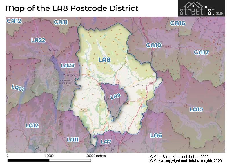
The LA8 Postcode shares a border with LA10 (SEDBERGH, Dent, Garsdale), LA6 (Ingleton, Kirkby Lonsdale, Holme), CA10 (Shap, Whinfell, Lazonby), LA23 (WINDERMERE, Bowness-on-Windermere, Troutbeck Bridge), LA9 (KENDAL, Burneside, Oxenholme), LA7 (MILNTHORPE, Storth, Heversham) and LA11 (GRANGE-OVER-SANDS, Flookburgh, Cartmel).
The primary settlement in the LA8 postcode district is Kendal, located in the county of Cumbria, England. Other significant settlements within this postcode district include Barrows Green, Crosscrake, Docker, Endmoor, Gatebeck, Howgill, Killington, Lambrigg, Levens, Levens Hall, Lowgill, New Hutton, Old Hutton, Oxenholme, Scalthwaiterigg, Sedgwick, Stainton, Bonningate, Brigsteer, Crook, Crosthwaite, Heaves, Helsington, Lyth, Sizergh, Underbarrow, Bowston, Burneside, Garnett Bridge, Garth Row, Grayrigg, Ings, Kentmere, Longsleddale, Mealbank, Patton, Plantation Bridge, Selside, Skelsmergh, Staveley, and Whinfell. The most significant Post Town in the LA8 postcode district is Kendal.
For the district LA8, we have data on 3 postcode sectors. Here's a breakdown: The sector LA8 0, covers Endmoor and Old Hutton and New Hutton and Sedgwick in Cumbria. The sector LA8 8, covers Levens and Crosthwaite and Underbarrow in Cumbria. The sector LA8 9, covers Staveley and Selside in Cumbria.

Map of the LA8 Postcode District
Explore the LA8 postcode district by using our free interactive map.
When it comes to local government, postal geography often disregards political borders. However, for a breakdown in the LA8 District: the district mostly encompasses the Westmorland and Furness area with a total of 498 postcodes.
Recent House Sales in LA8
| Date | Price | Address |
|---|---|---|
| 13/10/2023 | £462,000 | The Park, Old Hutton, Kendal, LA8 0NX |
| 28/09/2023 | £510,500 | Meadow Wood, Levens, Kendal, LA8 8EY |
| 18/09/2023 | £370,000 | Cowan Head, Kendal, LA8 9HL |
| 14/09/2023 | £360,000 | Laverock Hill, Mealbank, Kendal, LA8 9EP |
| 11/09/2023 | £375,000 | Howe Lane, Lyth, Kendal, LA8 8DF |
| 31/08/2023 | £530,000 | New Hutton, Kendal, LA8 0AS |
| 22/08/2023 | £150,000 | Levens, Kendal, LA8 8NZ |
| 21/08/2023 | £456,000 | Mealbank, Kendal, LA8 9DJ |
| 21/08/2023 | £475,000 | Church Close, Levens, Kendal, LA8 8QE |
| 21/08/2023 | £224,000 | Mealbank, Kendal, LA8 9DJ |
Weather Forecast for LA8
Press Button to Show Forecast for Kendal
| Time Period | Icon | Description | Temperature | Rain Probability | Wind |
|---|---|---|---|---|---|
| 03:00 to 06:00 | Clear night | 0.0°C (feels like -2.0°C) | 0.00% | ENE 2 mph | |
| 06:00 to 09:00 | Partly cloudy (day) | 2.0°C (feels like 1.0°C) | 0.00% | SSW 2 mph | |
| 09:00 to 12:00 | Cloudy | 7.0°C (feels like 5.0°C) | 34.00% | SSW 7 mph | |
| 12:00 to 15:00 | Light rain | 8.0°C (feels like 5.0°C) | 60.00% | WSW 11 mph | |
| 15:00 to 18:00 | Heavy rain | 8.0°C (feels like 5.0°C) | 87.00% | WSW 11 mph | |
| 18:00 to 21:00 | Heavy rain | 9.0°C (feels like 6.0°C) | 83.00% | WSW 13 mph | |
| 21:00 to 00:00 | Light rain | 9.0°C (feels like 6.0°C) | 55.00% | W 11 mph |
Press Button to Show Forecast for Kendal
| Time Period | Icon | Description | Temperature | Rain Probability | Wind |
|---|---|---|---|---|---|
| 00:00 to 03:00 | Cloudy | 8.0°C (feels like 6.0°C) | 15.00% | W 11 mph | |
| 03:00 to 06:00 | Cloudy | 8.0°C (feels like 5.0°C) | 34.00% | WNW 11 mph | |
| 06:00 to 09:00 | Cloudy | 7.0°C (feels like 5.0°C) | 8.00% | WNW 9 mph | |
| 09:00 to 12:00 | Cloudy | 9.0°C (feels like 6.0°C) | 7.00% | NW 16 mph | |
| 12:00 to 15:00 | Partly cloudy (day) | 11.0°C (feels like 8.0°C) | 3.00% | NW 16 mph | |
| 15:00 to 18:00 | Cloudy | 11.0°C (feels like 8.0°C) | 5.00% | NNW 13 mph | |
| 18:00 to 21:00 | Cloudy | 10.0°C (feels like 8.0°C) | 5.00% | NNW 9 mph | |
| 21:00 to 00:00 | Cloudy | 7.0°C (feels like 5.0°C) | 5.00% | N 7 mph |
Press Button to Show Forecast for Kendal
| Time Period | Icon | Description | Temperature | Rain Probability | Wind |
|---|---|---|---|---|---|
| 00:00 to 03:00 | Cloudy | 5.0°C (feels like 3.0°C) | 5.00% | NNE 4 mph | |
| 03:00 to 06:00 | Clear night | 3.0°C (feels like 1.0°C) | 1.00% | NE 4 mph | |
| 06:00 to 09:00 | Partly cloudy (day) | 4.0°C (feels like 2.0°C) | 1.00% | NNE 4 mph | |
| 09:00 to 12:00 | Partly cloudy (day) | 7.0°C (feels like 6.0°C) | 1.00% | NNW 4 mph | |
| 12:00 to 15:00 | Cloudy | 10.0°C (feels like 8.0°C) | 4.00% | NW 4 mph | |
| 15:00 to 18:00 | Partly cloudy (day) | 11.0°C (feels like 9.0°C) | 1.00% | NW 7 mph | |
| 18:00 to 21:00 | Sunny day | 10.0°C (feels like 9.0°C) | 1.00% | NW 4 mph | |
| 21:00 to 00:00 | Partly cloudy (night) | 5.0°C (feels like 4.0°C) | 1.00% | W 2 mph |
Press Button to Show Forecast for Kendal
| Time Period | Icon | Description | Temperature | Rain Probability | Wind |
|---|---|---|---|---|---|
| 00:00 to 03:00 | Partly cloudy (night) | 4.0°C (feels like 3.0°C) | 1.00% | SW 2 mph | |
| 03:00 to 06:00 | Partly cloudy (night) | 4.0°C (feels like 3.0°C) | 1.00% | N 2 mph | |
| 06:00 to 09:00 | Cloudy | 6.0°C (feels like 5.0°C) | 5.00% | NE 2 mph | |
| 09:00 to 12:00 | Cloudy | 9.0°C (feels like 9.0°C) | 5.00% | NNW 2 mph | |
| 12:00 to 15:00 | Cloudy | 12.0°C (feels like 11.0°C) | 5.00% | N 4 mph | |
| 15:00 to 18:00 | Cloudy | 13.0°C (feels like 12.0°C) | 5.00% | N 7 mph | |
| 18:00 to 21:00 | Cloudy | 12.0°C (feels like 11.0°C) | 5.00% | NNE 7 mph | |
| 21:00 to 00:00 | Cloudy | 8.0°C (feels like 7.0°C) | 5.00% | NNW 4 mph |
Where is the LA8 Postcode District?
The postcode district for LA8 is located in KENDAL. KENDAL is a nearby town to other towns such as Windermere, Ambleside, Sedbergh, Milnthorpe, Grange-over-Sands, and Appleby-in-Westmorland. The district is approximately 225.87 miles away from the center of London.
The district is within the post town of KENDAL.
The sector has postcodes within the nation of England.
The LA8 Postcode District is in the East Cumbria region of Cumbria within the North West (England).
| Postcode Sector | Delivery Office |
|---|---|
| LA8 0 | Kendal Delivery Office |
| LA8 8 | Levens Scale Payment Delivery Office |
| LA8 8 | Kendal Delivery Office |
| LA8 9 | Kendal Delivery Office |
| L | A | 8 | - | X | X | X |
| L | A | 8 | Space | Numeric | Letter | Letter |
Tourist Attractions within the Postcode Area
We found 1 visitor attractions within the LA8 postcode area
| Sizergh Castle and Garden |
|---|
| Historic Properties |
| Historic House / House and Garden / Palace |
| View Sizergh Castle and Garden on Google Maps |
Current Monthly Rental Prices
| # Bedrooms | Min Price | Max Price | Avg Price |
|---|---|---|---|
| 2 | £1,250 | £1,250 | £1,250 |
| 3 | £950 | £995 | £973 |
Current House Prices
| # Bedrooms | Min Price | Max Price | Avg Price |
|---|---|---|---|
| £25,000 | £800,000 | £202,143 | |
| 1 | £155,000 | £425,000 | £290,000 |
| 2 | £42,495 | £475,000 | £174,536 |
| 3 | £54,995 | £850,000 | £387,323 |
| 4 | £465,000 | £1,150,000 | £676,361 |
| 5 | £375,000 | £2,100,000 | £763,527 |
| 6 | £450,000 | £2,750,000 | £1,495,833 |
| 8 | £525,000 | £525,000 | £525,000 |
| 9 | £1,600,000 | £1,600,000 | £1,600,000 |
Estate Agents who Operate in the LA8 District
| Logo | Name | Brand Name | Address | Contact Number | Total Properties |
|---|---|---|---|---|---|
 | Kendal | Hackney & Leigh | 100 Stricklandgate Kendal Cumbria LA9 4PU | 01539 885313 | 12 |
 | Preston | Tempo Estates | 12 - 14 Preston Old Road, Freckleton, Preston, PR4 1PD | 01772 633399 | 10 |
 | The Lakes | AshdownJones | 1C Low Cleabarrow Business Centre Windermere Cumbria LA23 3ND | 01539 885290 | 10 |
 | Kendal | Thomson Hayton Winkley Estate Agents | 112 Stricklandgate Kendal LA9 4QA | 01539 885305 | 8 |
 | Lancaster | Mighty House | 53 Market Street Lancaster LA1 1JG | 01524 938548 | 8 |
- Bonning Gate
- Bowston
- Brigsteer
- Burneside
- Cowan Head
- Crook
- Crosthwaite
- Endmoor
- Garth Row
- Grayrigg
- Halfpenny
- Howgill
- Ings
- Kendal
- Kentmere
- Leasgill
- Levens
- Meal Bank
- Millholme
- Natland
- New Hutton
- Old Hutton
- Oxenholme
- Plumgarths
- Row
- Sampool
- Sandside
- Sedgwick
- Skelsmergh
- Stainton
- Staveley
- Summerlands
- Underbarrow
- Windermere
- Winster
| Type of Property | 2018 Average | 2018 Sales | 2017 Average | 2017 Sales | 2016 Average | 2016 Sales | 2015 Average | 2015 Sales |
|---|---|---|---|---|---|---|---|---|
| Detached | £393,296 | 69 | £395,664 | 68 | £405,046 | 61 | £357,936 | 55 |
| Semi-Detached | £248,135 | 47 | £312,859 | 43 | £274,114 | 22 | £271,185 | 30 |
| Terraced | £248,238 | 38 | £289,119 | 36 | £223,717 | 30 | £247,199 | 29 |
| Flats | £274,611 | 9 | £223,341 | 11 | £215,259 | 4 | £212,548 | 6 |
Hotels within the Postcode Area
We found 24 hotels and guest houses within the LA8 postcode area
Days Inn Kendal - Killington Lake
Killington Lake Motorway Service Area, M6 Southbound, Kendal, kendal, LA8 0NW.
View detailsTranthwaite Hall Bed & Breakfast
Tranthwaite Hall Underbarrow, Kendal, kendal, LA8 8HG.
View detailsMillers Beck Country Guest House and Self Catering
Millbridge Lane, Stainton, Kendal, kendal, LA8 0DU.
View detailsThe Lodge at High Gregg Hall Farm
The Lodge, High Gregg Hall Farm, Underbarrow, Cumbria. LA8 8BL, Under Arrow, underbarrow, LA8 8BL.
View detailsThe Hare and Hounds, Levens
The Hare and Hounds, Levens, Cumbria, Levens, levens, LA8 8PN.
View details