The LD3 postcode district is a postal district located in the LD Llandrindod Wells postcode area with a population of 19,512 residents according to the 2021 England and Wales Census.
The area of the LD3 postcode district is 295.15 square miles which is 764.44 square kilometres or 188,897.25 acres.
Currently, the LD3 district has about 877 postcode units spread across 4 geographic postcode sectors.
Given that each sector allows for 400 unique postcode combinations, the district has a capacity of 1,600 postcodes. With 877 postcodes already in use, this leaves 723 units available.
The largest settlement in the LD3 postal code is BRECON followed by TALGARTH, and LLAN-FAES.
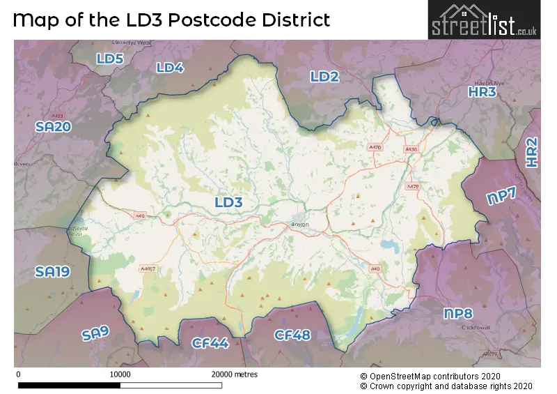
The LD3 Postcode shares a border with LD2 (BUILTH WELLS, LLANELWEDD, LLANAFANFAWR), LD4 (LLANGAMMARCH WELLS, GARTH, TIRABAD), SA20 (LLANDOVERY, RHANDIRMWYN, CYNGHORDY), HR3 (HAY-ON-WYE, Eardisley, GLASBURY), NP7 (ABERGAVENNY, Gilwern, Llanfoist), CF44 (ABERDARE, HIRWAUN, Aberaman), CF48 (DOWLAIS, MERTHYR TYDFIL, TROEDYRHIW), NP8 (CRICKHOWELL, LLANGYNIDR, LLANGATTOCK) and SA9 (YSTRADGYNLAIS, Ystalyfera, LOWER CWMTWRCH).
The primary settlement in the LD3 postcode district is Brecon, located in the county of Powys in Wales. Other significant settlements in this district include Talgarth, which also belongs to the county of Powys, and Bwlch. The main post town in this district is Brecon.
For the district LD3, we have data on 5 postcode sectors. Here's a breakdown: The sector LD3 0, covers Talgarth and Bronllys in Powys. The sector LD3 3 is non-geographic. It's often designated for PO Boxes, large organisations, or special services. The sector LD3 7, covers Brecon and Talybont-On-Usk in Powys. The sector LD3 8, covers Brecon and Sennybridge in Powys. The sector LD3 9, covers Brecon in Powys.

Map of the LD3 Postcode District
Explore the LD3 postcode district by using our free interactive map.
When it comes to local government, postal geography often disregards political borders. However, for a breakdown in the LD3 District: the district mostly encompasses the Powys - Powys area with a total of 875 postcodes.
Recent House Sales in LD3
| Date | Price | Address |
|---|---|---|
| 27/10/2023 | £330,000 | Beech Grove, Brecon, LD3 9EY |
| 11/10/2023 | £124,000 | Hay Road, Brecon, LD3 9SW |
| 28/09/2023 | £215,000 | Coedwaungar, Sennybridge, Brecon, LD3 8TP |
| 14/09/2023 | £855,000 | Three Cocks, Brecon, LD3 0SW |
| 13/09/2023 | £262,500 | Westfields, Talgarth, Brecon, LD3 0HG |
| 12/09/2023 | £530,000 | Llanfilo, Brecon, LD3 0RE |
| 12/09/2023 | £220,000 | Coed Y Bryn, Bwlch, Brecon, LD3 7HJ |
| 05/09/2023 | £360,000 | Regent Street, Talgarth, Brecon, LD3 0DB |
| 05/09/2023 | £327,500 | Church Row, Talgarth, Brecon, LD3 0BE |
| 04/09/2023 | £98,500 | Gwenllian Morgan Court, Brecon, LD3 7EE |
Weather Forecast for LD3
Press Button to Show Forecast for Brecon
| Time Period | Icon | Description | Temperature | Rain Probability | Wind |
|---|---|---|---|---|---|
| 00:00 to 03:00 | Partly cloudy (night) | 4.0°C (feels like 3.0°C) | 1.00% | NW 2 mph | |
| 03:00 to 06:00 | Clear night | 3.0°C (feels like 1.0°C) | 0.00% | WNW 2 mph | |
| 06:00 to 09:00 | Sunny day | 3.0°C (feels like 2.0°C) | 0.00% | N 2 mph | |
| 09:00 to 12:00 | Partly cloudy (day) | 9.0°C (feels like 9.0°C) | 3.00% | NNW 2 mph | |
| 12:00 to 15:00 | Cloudy | 12.0°C (feels like 11.0°C) | 5.00% | N 4 mph | |
| 15:00 to 18:00 | Cloudy | 13.0°C (feels like 12.0°C) | 4.00% | NNE 4 mph | |
| 18:00 to 21:00 | Cloudy | 12.0°C (feels like 11.0°C) | 8.00% | N 4 mph | |
| 21:00 to 00:00 | Cloudy | 8.0°C (feels like 7.0°C) | 4.00% | NE 2 mph |
Press Button to Show Forecast for Brecon
| Time Period | Icon | Description | Temperature | Rain Probability | Wind |
|---|---|---|---|---|---|
| 00:00 to 03:00 | Clear night | 5.0°C (feels like 4.0°C) | 0.00% | ENE 2 mph | |
| 03:00 to 06:00 | Clear night | 3.0°C (feels like 2.0°C) | 0.00% | NNW 2 mph | |
| 06:00 to 09:00 | Sunny day | 5.0°C (feels like 4.0°C) | 1.00% | NNW 2 mph | |
| 09:00 to 12:00 | Partly cloudy (day) | 10.0°C (feels like 9.0°C) | 1.00% | NE 4 mph | |
| 12:00 to 15:00 | Cloudy | 12.0°C (feels like 11.0°C) | 5.00% | NNE 7 mph | |
| 15:00 to 18:00 | Overcast | 12.0°C (feels like 11.0°C) | 8.00% | NNE 7 mph | |
| 18:00 to 21:00 | Cloudy | 11.0°C (feels like 9.0°C) | 8.00% | NE 7 mph | |
| 21:00 to 00:00 | Cloudy | 7.0°C (feels like 6.0°C) | 4.00% | NE 4 mph |
Press Button to Show Forecast for Brecon
| Time Period | Icon | Description | Temperature | Rain Probability | Wind |
|---|---|---|---|---|---|
| 00:00 to 03:00 | Cloudy | 6.0°C (feels like 5.0°C) | 4.00% | NE 4 mph | |
| 03:00 to 06:00 | Cloudy | 5.0°C (feels like 4.0°C) | 5.00% | ENE 2 mph | |
| 06:00 to 09:00 | Cloudy | 6.0°C (feels like 5.0°C) | 5.00% | ENE 2 mph | |
| 09:00 to 12:00 | Overcast | 9.0°C (feels like 8.0°C) | 11.00% | NW 4 mph | |
| 12:00 to 15:00 | Overcast | 10.0°C (feels like 9.0°C) | 12.00% | NW 7 mph | |
| 15:00 to 18:00 | Light rain | 12.0°C (feels like 10.0°C) | 43.00% | NNW 9 mph | |
| 18:00 to 21:00 | Cloudy | 10.0°C (feels like 9.0°C) | 11.00% | N 7 mph | |
| 21:00 to 00:00 | Cloudy | 8.0°C (feels like 7.0°C) | 8.00% | NNE 4 mph |
Press Button to Show Forecast for Brecon
| Time Period | Icon | Description | Temperature | Rain Probability | Wind |
|---|---|---|---|---|---|
| 00:00 to 03:00 | Cloudy | 7.0°C (feels like 6.0°C) | 6.00% | NE 4 mph | |
| 03:00 to 06:00 | Cloudy | 7.0°C (feels like 6.0°C) | 7.00% | N 2 mph | |
| 06:00 to 09:00 | Cloudy | 7.0°C (feels like 6.0°C) | 18.00% | N 2 mph | |
| 09:00 to 12:00 | Cloudy | 10.0°C (feels like 9.0°C) | 6.00% | N 7 mph | |
| 12:00 to 15:00 | Light rain shower (day) | 12.0°C (feels like 11.0°C) | 27.00% | N 9 mph | |
| 15:00 to 18:00 | Cloudy | 12.0°C (feels like 10.0°C) | 8.00% | N 9 mph | |
| 18:00 to 21:00 | Partly cloudy (day) | 11.0°C (feels like 9.0°C) | 11.00% | N 9 mph | |
| 21:00 to 00:00 | Clear night | 8.0°C (feels like 7.0°C) | 10.00% | NNE 4 mph |
Where is the LD3 Postcode District?
The LD3 postcode district is located in Brecon, a town in Wales. It is situated near several towns, including Meifod to the South East (10.88 miles away), Builth Wells to the North (11.80 miles away), Llangammarch Wells to the North West (11.93 miles away), Merthyr Tydfil to the South (14.46 miles away), and Llandovery to the West (15.63 miles away). Additionally, the LD3 postcode district is approximately 145.24 miles away from the centre of London.
The district is within the post town of BRECON.
The sector has postcodes within the nation of Wales.
The LD3 Postcode District is in the Powys region of East Wales within the Wales.
| Postcode Sector | Delivery Office |
|---|---|
| LD3 0 | Brecon Delivery Office |
| LD3 1 | Brecon Delivery Office |
| LD3 2 | Brecon Delivery Office |
| LD3 3 | Brecon Delivery Office |
| LD3 4 | Brecon Delivery Office |
| LD3 5 | Brecon Delivery Office |
| LD3 6 | Brecon Delivery Office |
| LD3 7 | Brecon Delivery Office |
| LD3 8 | Brecon Delivery Office |
| LD3 9 | Brecon Delivery Office |
| L | D | 3 | - | X | X | X |
| L | D | 3 | Space | Numeric | Letter | Letter |
Tourist Attractions within the Postcode Area
We found 2 visitor attractions within the LD3 postcode area
| Brecknock Museum & Art Gallery |
|---|
| View Brecknock Museum & Art Gallery on Google Maps |
| The Regimental Museum of The Royal Welsh |
| View The Regimental Museum of The Royal Welsh on Google Maps |
Current Monthly Rental Prices
| # Bedrooms | Min Price | Max Price | Avg Price |
|---|---|---|---|
| 2 | £450 | £450 | £450 |
| 3 | £750 | £750 | £750 |
| 4 | £1,400 | £1,400 | £1,400 |
Current House Prices
| # Bedrooms | Min Price | Max Price | Avg Price |
|---|---|---|---|
| £60,000 | £695,000 | £264,444 | |
| 1 | £110,000 | £625,000 | £247,500 |
| 2 | £130,000 | £795,000 | £311,065 |
| 3 | £170,000 | £800,000 | £339,939 |
| 4 | £200,000 | £1,450,000 | £552,364 |
| 5 | £139,950 | £1,400,000 | £616,636 |
| 6 | £725,000 | £895,000 | £818,333 |
| 7 | £435,000 | £1,700,000 | £1,177,000 |
| 8 | £500,000 | £5,000,000 | £1,679,000 |
| 9 | £895,000 | £1,665,000 | £1,153,333 |
| 10 | £1,350,000 | £1,700,000 | £1,583,333 |
| 11 | £2,400,000 | £2,400,000 | £2,400,000 |
Estate Agents who Operate in the LD3 District
| Logo | Name | Brand Name | Address | Contact Number | Total Properties |
|---|---|---|---|---|---|
 | Brecon | James.Dean | 19 Ship Street, Brecon, LD3 9AD | 01874 641259 | 70 |
 | Brecon | McCartneys LLP | 40 High Street, Brecon, LD3 7AP | 01874 640382 | 22 |
 | Brecon | Fine & Country | 40 High Street, Brecon, LD3 7AP | 01874 641300 | 15 |
 | Hay-On-Wye | Chancellors | 16a Castle Street, Hay-On-Wye, HR3 5DF | 01497 701043 | 11 |
 | Brecon | Clee Tompkinson & Francis | 13 Lion Street, Brecon, LD3 7HY | 01874 640385 | 8 |
- Aberhonddu
- Aberllynfi
- Battle
- Bochrwyd
- Bronllys
- Bwlch
- Cradoc
- Cwmdu
- Defynnog
- Erwyd
- Felindre
- Felinfach
- Glyntawe
- Groesffordd
- Llanddew
- Llanfihangel Tal-y-llyn
- Llanfrynach
- Llangors
- Llangynidr
- Llanspyddid
- Llyswen
- Lower Chapel
- Pennorth
- Pwllgloyw
- Sennybridge
- Tai'r Bull
- Talgarth
- Talybont-on-Usk
- Trecastle
- Trefecca
- Upper Chapel
| Type of Property | 2018 Average | 2018 Sales | 2017 Average | 2017 Sales | 2016 Average | 2016 Sales | 2015 Average | 2015 Sales |
|---|---|---|---|---|---|---|---|---|
| Detached | £325,269 | 114 | £274,547 | 111 | £282,261 | 111 | £264,653 | 101 |
| Semi-Detached | £196,249 | 89 | £191,225 | 66 | £185,266 | 80 | £178,879 | 59 |
| Terraced | £163,597 | 66 | £155,003 | 80 | £161,967 | 80 | £146,797 | 75 |
| Flats | £147,000 | 6 | £117,600 | 5 | £113,667 | 9 | £100,100 | 10 |
Hotels within the Postcode Area
We found 43 hotels and guest houses within the LD3 postcode area
Peterstone Court Country House Restaurant & Spa
Llanhamlach, Brecon, Powys, brecon-powys, LD3 7YB.
View detailsAbereithrin Cottage
Abereithrin, Pentrebach, Sennybridge, Brecon, pentre-bach, LD3 8UB.
View detailsCaebetran Farm & The Stable
Caebetran Farm, Felinfach, Brecon, Powys, Brecon, llandefalle, LD3 0UL.
View details