The LE1 7 postcode sector is within the county of Leicestershire.
Did you know? According to the 2021 Census, the LE1 7 postcode sector is home to a bustling 1,307 residents!
Given that each sector allows for 400 unique postcode combinations. Letters C, I, K, M, O and V are not allowed in the last two letters of a postcode. With 73 postcodes already in use, this leaves 327 units available.
The LE1 7 postal code covers the settlement of LEICESTER.
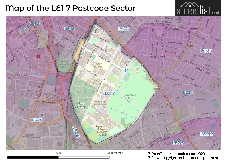
The LE1 7 Postcode shares a border with LE1 6 (LEICESTER), LE2 0 (LEICESTER), LE2 1 (LEICESTER) and LE2 6 (LEICESTER).
The sector is within the post town of LEICESTER.
LE1 7 is a postcode sector within the LE1 postcode district which is within the LE Leicester postcode area.
The Royal Mail delivery office for the LE1 7 postal sector is the Leicester Central Delivery Office.
The area of the LE1 7 postcode sector is 0.36 square miles which is 0.92 square kilometres or 227.44 square acres.

Map of the LE1 7 Postcode Sector
Explore the LE1 7 postcode sector by using our free interactive map.
| L | E | 1 | - | 7 | X | X |
| L | E | 1 | Space | 7 | Letter | Letter |
Official List of Streets
LEICESTER (21 Streets)
Unofficial Streets or Alternative Spellings
Weather Forecast for LE1 7
Press Button to Show Forecast for Clarendon Park
| Time Period | Icon | Description | Temperature | Rain Probability | Wind |
|---|---|---|---|---|---|
| 21:00 to 00:00 | Cloudy | 7.0°C (feels like 5.0°C) | 3.00% | N 7 mph |
Press Button to Show Forecast for Clarendon Park
| Time Period | Icon | Description | Temperature | Rain Probability | Wind |
|---|---|---|---|---|---|
| 00:00 to 03:00 | Overcast | 6.0°C (feels like 3.0°C) | 7.00% | NNW 7 mph | |
| 03:00 to 06:00 | Cloudy | 5.0°C (feels like 3.0°C) | 3.00% | NNW 9 mph | |
| 06:00 to 09:00 | Cloudy | 5.0°C (feels like 2.0°C) | 3.00% | N 9 mph | |
| 09:00 to 12:00 | Cloudy | 7.0°C (feels like 3.0°C) | 3.00% | N 11 mph | |
| 12:00 to 15:00 | Overcast | 8.0°C (feels like 6.0°C) | 8.00% | N 11 mph | |
| 15:00 to 18:00 | Cloudy | 10.0°C (feels like 7.0°C) | 7.00% | N 9 mph | |
| 18:00 to 21:00 | Cloudy | 9.0°C (feels like 8.0°C) | 7.00% | N 7 mph | |
| 21:00 to 00:00 | Cloudy | 6.0°C (feels like 5.0°C) | 4.00% | E 7 mph |
Press Button to Show Forecast for Clarendon Park
| Time Period | Icon | Description | Temperature | Rain Probability | Wind |
|---|---|---|---|---|---|
| 00:00 to 03:00 | Cloudy | 5.0°C (feels like 3.0°C) | 4.00% | WSW 4 mph | |
| 03:00 to 06:00 | Cloudy | 4.0°C (feels like 1.0°C) | 4.00% | WSW 7 mph | |
| 06:00 to 09:00 | Cloudy | 4.0°C (feels like 2.0°C) | 6.00% | W 7 mph | |
| 09:00 to 12:00 | Cloudy | 8.0°C (feels like 5.0°C) | 9.00% | WNW 9 mph | |
| 12:00 to 15:00 | Overcast | 9.0°C (feels like 7.0°C) | 14.00% | NW 9 mph | |
| 15:00 to 18:00 | Cloudy | 10.0°C (feels like 8.0°C) | 10.00% | NW 9 mph | |
| 18:00 to 21:00 | Cloudy | 8.0°C (feels like 6.0°C) | 10.00% | N 7 mph | |
| 21:00 to 00:00 | Cloudy | 6.0°C (feels like 4.0°C) | 5.00% | NNE 4 mph |
Press Button to Show Forecast for Clarendon Park
| Time Period | Icon | Description | Temperature | Rain Probability | Wind |
|---|---|---|---|---|---|
| 00:00 to 03:00 | Cloudy | 4.0°C (feels like 2.0°C) | 4.00% | ENE 4 mph | |
| 03:00 to 06:00 | Cloudy | 3.0°C (feels like 1.0°C) | 5.00% | ENE 4 mph | |
| 06:00 to 09:00 | Cloudy | 4.0°C (feels like 1.0°C) | 9.00% | NE 4 mph | |
| 09:00 to 12:00 | Cloudy | 7.0°C (feels like 5.0°C) | 10.00% | E 7 mph | |
| 12:00 to 15:00 | Overcast | 10.0°C (feels like 8.0°C) | 17.00% | E 7 mph | |
| 15:00 to 18:00 | Overcast | 10.0°C (feels like 8.0°C) | 18.00% | ESE 9 mph | |
| 18:00 to 21:00 | Overcast | 9.0°C (feels like 7.0°C) | 16.00% | E 9 mph | |
| 21:00 to 00:00 | Overcast | 7.0°C (feels like 5.0°C) | 16.00% | E 9 mph |
Press Button to Show Forecast for Clarendon Park
| Time Period | Icon | Description | Temperature | Rain Probability | Wind |
|---|---|---|---|---|---|
| 00:00 to 03:00 | Cloudy | 6.0°C (feels like 3.0°C) | 20.00% | ESE 9 mph | |
| 03:00 to 06:00 | Overcast | 5.0°C (feels like 3.0°C) | 24.00% | E 7 mph | |
| 06:00 to 09:00 | Cloudy | 6.0°C (feels like 3.0°C) | 17.00% | E 9 mph | |
| 09:00 to 12:00 | Overcast | 9.0°C (feels like 6.0°C) | 18.00% | E 9 mph | |
| 12:00 to 15:00 | Overcast | 11.0°C (feels like 9.0°C) | 21.00% | E 9 mph | |
| 15:00 to 18:00 | Cloudy | 12.0°C (feels like 9.0°C) | 19.00% | E 11 mph | |
| 18:00 to 21:00 | Light rain shower (day) | 10.0°C (feels like 8.0°C) | 35.00% | ENE 9 mph | |
| 21:00 to 00:00 | Cloudy | 9.0°C (feels like 7.0°C) | 17.00% | E 9 mph |
Schools and Places of Education Within the LE1 7 Postcode Sector
WQE and Regent College Group
Further education
University Road, Leicester, Leicestershire, LE1 7RJ
Head: Mr Paul Wilson
Ofsted Rating: Good
Inspection: 2022-03-25 (760 days ago)
Website: Visit WQE and Regent College Group Website
Phone: 01162471147
Number of Pupils: 0
House Prices in the LE1 7 Postcode Sector
| Type of Property | 2018 Average | 2018 Sales | 2017 Average | 2017 Sales | 2016 Average | 2016 Sales | 2015 Average | 2015 Sales |
|---|---|---|---|---|---|---|---|---|
| Detached | £0 | 0 | £393,750 | 2 | £181,500 | 1 | £0 | 0 |
| Semi-Detached | £0 | 0 | £0 | 0 | £177,717 | 3 | £0 | 0 |
| Terraced | £385,000 | 1 | £326,340 | 2 | £290,000 | 2 | £272,667 | 3 |
| Flats | £187,200 | 5 | £189,962 | 13 | £194,139 | 14 | £162,902 | 26 |
Important Postcodes LE1 7 in the Postcode Sector
LE1 7AB is the postcode for The Museum Studies Building, 19 University Road
LE1 7BA is the postcode for NHS Dental Access Centre, 10 Nelson Street
LE1 7DA is the postcode for Prospect House, 94 Regents Road
LE1 7DD is the postcode for UNIVERSITY OF LEICESTER, Enkalon House, 86-92 Regent Road, HM REVENUE & CUSTOMS, Valuation Office, Enkalon House, 86-92 Regent Road, and Valuation Office, Enkalon House, 86-92 Regent Road
LE1 7DF is the postcode for University of Leicester, Readson House, 96-98 Regent Road, Reasdon House, 96-98 Regent Road, Readson House, University of Leicester, 96-98 Regent Road, and Prospect House, University of Leicester, 94 Regent Road
LE1 7DQ is the postcode for University of Leicester, 54 Princess Road East
LE1 7EA is the postcode for Museum & Art Gallery, 53 New Walk, and 106, New Walk
LE1 7HA is the postcode for George Davies Building, University of Leicester, Lancaster Road, and University of Leicester, Centre for Medicine
LE1 7HB is the postcode for Central Fire and Rescue Station, Lancaster Place, Preclinical Research Facility, University of Leicester, Lancaster Road, WORKSHOPS, Central Fire and Rescue Station, Lancaster Place, and Attenborough Arts Centre, University of Leicester, Lancaster Road
LE1 7JA is the postcode for Bankfield House, 132 New Walk, and Bankfield House, University of Leicester, 132 New Walk
LE1 7LA is the postcode for Squash Courts, 121 Princess Road East, School of Social Work, 107-109 Princess Road East, 107-111 Princess Road East, University of Leicester, and 107-111 Princess Road East
LE1 7LG is the postcode for University of Leicester, 103-105 Princess Road East
LE1 7LT is the postcode for 118, Regent Road
LE1 7LW is the postcode for Regent College New Sports Hall, Regent College, Regent Road, Regent Road Campus, Wyggeston & Queen Elizabeth 1 College, Regent Road, Regent Road Campus, Wyggeston & Queen Elizabeth 1 College, and REGENT COLLEGE NEW SPORTS HALL, Regent Road Campus, Wyggeston & Queen Elizabeth 1 College
LE1 7PA is the postcode for University of Leicester, 128 Regent Road
LE1 7QA is the postcode for 152-154 Upper New Walk, 152-154 Upper New Walk, University of Leicester, and 162-166 Upper New Walk
LE1 7QR is the postcode for 7-9, Salisbury Road, 14, Salisbury Road, 1, Salisbury Road, University of Leicester, Marc Fitch House, 3-5 Salisbury Road, and 6, Salisbury Road
LE1 7RA is the postcode for Fraser Noble Building, University of Leicester, 2 University Road
LE1 7RB is the postcode for 6, University Road, Fraser Noble Building, 2 University Road, and Science Learning Centre, 2 University Road
LE1 7RF is the postcode for School of Education, 21 University Road
LE1 7RH is the postcode for BENNETT BUILDING, University of Leicester, University Road, CHARLES WILSON BUILDING, University of Leicester, University Road, BENNETT LINK, University of Leicester, University Road, GEORGE PORTER BUILDING, University of Leicester, University Road, INFORMATIKS BUILDING, University of Leicester, University Road, MICHAEL ATIYAH ANNEXE, University of Leicester, University Road, COLLEGE HOUSE, University of Leicester, University Road, Maurice Shock Medical Sciences Building (MSB), University of Leicester, University Road, PERCY GEE BUILDING, University of Leicester, University Road, DAVID WILSON LIBRARY, University of Leicester, University Road, ARCHAEOLOGY & ANCIENT HISTORY BUILDING, University of Leicester, University Road, PHYSICS & ASTRONOMY BUILDING, University of Leicester, University Road, ASTLEY CLARKE BUILDING, University of Leicester, University Road, ENGINEERING BUILDING, University of Leicester, University Road, ATTENBOROUGH SEMINAR BLOCK, University of Leicester, University Road, MICHAEL ATIYAH BUILDING, University of Leicester, University Road, ENGINEERING DESIGN LABORATORY, University of Leicester, University Road, FIELDING JOHNSON BUILDING, University of Leicester, University Road, 15, University of Leicester, University Road, RATTRAY LECTURE THEATRE, University of Leicester, University Road, BENNETT-PHYSICS UNDERPASS, University of Leicester, University Road, ADRIAN BUILDING, University of Leicester, University Road, Computer/Materials Centre, University of Leicester, University Road, Informatics Building, University of Leicester, University Road, COMPUTER BIO CENTRE, University of Leicester, University Road, KEN EDWARDS BUILDING, University of Leicester, University Road, and ATTENBOROUGH TOWER, University of Leicester, University Road
LE1 7RJ is the postcode for MAIN BUILDING, Wyggeston & Queen Elizabeth I College, University Road, Danielle Brown Sports Centre, Wyggeston Drive, University Road, Danielle Brown Sports Centre, Wyggeston Drive, B BLOCK, Wyggeston & Queen Elizabeth I College, University Road, JAMES WENT BUILDING, Wyggeston & Queen Elizabeth I College, University Road, J BUILDING, Wyggeston & Queen Elizabeth I College, University Road, Wyggeston & Queen Elizabeth I College, University Road, and G BUILDING, Wyggeston & Queen Elizabeth I College, University Road
LE1 7RU is the postcode for De Montfort Hall, Granville Road, Leicester City Council, De Montfort Hall, Granville Road, and DE MONTFORT HALL, GRANVILLE ROAD, LEICESTER
| The LE1 7 Sector is within these Local Authorities |
|
|---|---|
| The LE1 7 Sector is within these Counties |
|
| The LE1 7 Sector is within these Water Company Areas |
|