The LE11 2 postcode sector is within the county of Leicestershire.
Did you know? According to the 2021 Census, the LE11 2 postcode sector is home to a bustling 16,441 residents!
Given that each sector allows for 400 unique postcode combinations. Letters C, I, K, M, O and V are not allowed in the last two letters of a postcode. With 301 postcodes already in use, this leaves 99 units available.
The LE11 2 postal code covers the settlement of LOUGHBOROUGH.
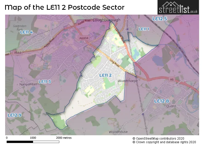
The LE11 2 Postcode shares a border with LE11 3 (LOUGHBOROUGH, Nanpantan), LE12 8 (Barrow Upon Soar, Quorn, Woodhouse Eaves), LE11 1 (LOUGHBOROUGH) and LE11 5 (LOUGHBOROUGH).
The sector is within the post town of LOUGHBOROUGH.
LE11 2 is a postcode sector within the LE11 postcode district which is within the LE Leicester postcode area.
The Royal Mail delivery office for the LE11 2 postal sector is the Loughborough Delivery Office.
The area of the LE11 2 postcode sector is 2.16 square miles which is 5.59 square kilometres or 1,381.40 square acres.
Waterways within the LE11 2 postcode sector include the Grand Union Canal.

Map of the LE11 2 Postcode Sector
Explore the LE11 2 postcode sector by using our free interactive map.
| L | E | 1 | 1 | - | 2 | X | X |
| L | E | 1 | 1 | Space | 2 | Letter | Letter |
Official List of Streets
LOUGHBOROUGH (190 Streets)
Unofficial Streets or Alternative Spellings
LOUGHBOROUGH
ALBERT PROMENADE BARROW STREET BAXTER GATE BROWNS LANE COLGROVE ROAD EPINAL WAY FACTORY STREET GREGORY STREET HOLT DRIVE KING EDWARD ROAD KING STREET MARKET PLACE MOIRA STREET OUTWOODS DRIVE PINFOLD GATE SOUTH STREET SWAN STREET VALLEY ROAD WALLACE ROAD WINDMILL ROADWoodthorpe
MAIN STREETNanpantan
WOODHOUSE LANEWeather Forecast for LE11 2
Press Button to Show Forecast for Loughborough
| Time Period | Icon | Description | Temperature | Rain Probability | Wind |
|---|---|---|---|---|---|
| 03:00 to 06:00 | Cloudy | 4.0°C (feels like 2.0°C) | 4.00% | WSW 7 mph | |
| 06:00 to 09:00 | Cloudy | 5.0°C (feels like 2.0°C) | 45.00% | W 7 mph | |
| 09:00 to 12:00 | Cloudy | 7.0°C (feels like 5.0°C) | 32.00% | W 9 mph | |
| 12:00 to 15:00 | Light rain | 8.0°C (feels like 5.0°C) | 54.00% | NNW 9 mph | |
| 15:00 to 18:00 | Cloudy | 8.0°C (feels like 7.0°C) | 14.00% | NNE 4 mph | |
| 18:00 to 21:00 | Cloudy | 8.0°C (feels like 7.0°C) | 6.00% | NE 4 mph | |
| 21:00 to 00:00 | Partly cloudy (night) | 5.0°C (feels like 3.0°C) | 3.00% | E 4 mph |
Press Button to Show Forecast for Loughborough
| Time Period | Icon | Description | Temperature | Rain Probability | Wind |
|---|---|---|---|---|---|
| 00:00 to 03:00 | Partly cloudy (night) | 3.0°C (feels like 1.0°C) | 2.00% | ENE 4 mph | |
| 03:00 to 06:00 | Partly cloudy (night) | 2.0°C (feels like 0.0°C) | 1.00% | NE 2 mph | |
| 06:00 to 09:00 | Sunny day | 2.0°C (feels like 1.0°C) | 1.00% | NE 4 mph | |
| 09:00 to 12:00 | Partly cloudy (day) | 7.0°C (feels like 5.0°C) | 1.00% | NE 7 mph | |
| 12:00 to 15:00 | Cloudy | 9.0°C (feels like 8.0°C) | 10.00% | NE 4 mph | |
| 15:00 to 18:00 | Overcast | 10.0°C (feels like 9.0°C) | 11.00% | NE 4 mph | |
| 18:00 to 21:00 | Cloudy | 8.0°C (feels like 6.0°C) | 9.00% | ENE 7 mph | |
| 21:00 to 00:00 | Partly cloudy (night) | 5.0°C (feels like 3.0°C) | 6.00% | ENE 7 mph |
Press Button to Show Forecast for Loughborough
| Time Period | Icon | Description | Temperature | Rain Probability | Wind |
|---|---|---|---|---|---|
| 00:00 to 03:00 | Partly cloudy (night) | 4.0°C (feels like 2.0°C) | 7.00% | ENE 4 mph | |
| 03:00 to 06:00 | Cloudy | 3.0°C (feels like 1.0°C) | 12.00% | NE 4 mph | |
| 06:00 to 09:00 | Cloudy | 4.0°C (feels like 2.0°C) | 11.00% | NE 7 mph | |
| 09:00 to 12:00 | Cloudy | 8.0°C (feels like 6.0°C) | 12.00% | ENE 9 mph | |
| 12:00 to 15:00 | Overcast | 10.0°C (feels like 8.0°C) | 21.00% | ENE 9 mph | |
| 15:00 to 18:00 | Overcast | 11.0°C (feels like 8.0°C) | 21.00% | ENE 11 mph | |
| 18:00 to 21:00 | Cloudy | 10.0°C (feels like 7.0°C) | 17.00% | ENE 11 mph | |
| 21:00 to 00:00 | Cloudy | 7.0°C (feels like 4.0°C) | 16.00% | NE 11 mph |
Press Button to Show Forecast for Loughborough
| Time Period | Icon | Description | Temperature | Rain Probability | Wind |
|---|---|---|---|---|---|
| 00:00 to 03:00 | Overcast | 7.0°C (feels like 4.0°C) | 21.00% | NE 11 mph | |
| 03:00 to 06:00 | Light rain | 7.0°C (feels like 4.0°C) | 54.00% | NE 13 mph | |
| 06:00 to 09:00 | Heavy rain | 7.0°C (feels like 4.0°C) | 78.00% | NE 13 mph | |
| 09:00 to 12:00 | Heavy rain | 9.0°C (feels like 6.0°C) | 78.00% | NE 11 mph | |
| 12:00 to 15:00 | Heavy rain | 10.0°C (feels like 8.0°C) | 73.00% | NE 11 mph | |
| 15:00 to 18:00 | Light rain shower (day) | 11.0°C (feels like 8.0°C) | 42.00% | NNE 11 mph | |
| 18:00 to 21:00 | Light rain shower (day) | 10.0°C (feels like 8.0°C) | 38.00% | NNE 9 mph | |
| 21:00 to 00:00 | Overcast | 8.0°C (feels like 6.0°C) | 14.00% | S 7 mph |
Schools and Places of Education Within the LE11 2 Postcode Sector
Beacon Academy
Academy sponsor led
Woodthorpe Road, Loughborough, Leicestershire, LE11 2NF
Head: Mr Ben Kilgannon
Ofsted Rating: Good
Inspection: 2021-11-24 (883 days ago)
Website: Visit Beacon Academy Website
Phone: 01509212227
Number of Pupils: 328
Outwoods Edge Primary School
Academy converter
21 Redwood Road, Loughborough, Leicestershire, LE11 2LD
Head: Mr Mark Wilson
Ofsted Rating: Good
Inspection: 2021-10-13 (925 days ago)
Website: Visit Outwoods Edge Primary School Website
Phone: 01509216177
Number of Pupils: 414
Sacred Heart Catholic Voluntary Academy
Academy converter
Beacon Road, Loughborough, Leicestershire, LE11 2BG
Head: Mrs Lisa Atkins
Ofsted Rating: Good
Inspection: 2020-03-04 (1513 days ago)
Website: Visit Sacred Heart Catholic Voluntary Academy Website
Phone: 01509212204
Number of Pupils: 193
Woodbrook Vale School
Academy converter
Grasmere Road, Loughborough, Leicestershire, LE11 2ST
Head: Mrs Rachael Fraser
Ofsted Rating: Good
Inspection: 2022-02-09 (806 days ago)
Website: Visit Woodbrook Vale School Website
Phone: 01509557560
Number of Pupils: 837
House Prices in the LE11 2 Postcode Sector
| Type of Property | 2018 Average | 2018 Sales | 2017 Average | 2017 Sales | 2016 Average | 2016 Sales | 2015 Average | 2015 Sales |
|---|---|---|---|---|---|---|---|---|
| Detached | £302,936 | 132 | £307,228 | 138 | £291,003 | 139 | £264,910 | 108 |
| Semi-Detached | £203,252 | 149 | £191,553 | 126 | £189,036 | 109 | £165,537 | 96 |
| Terraced | £197,960 | 85 | £172,819 | 92 | £173,368 | 71 | £157,628 | 66 |
| Flats | £127,838 | 16 | £104,196 | 24 | £97,646 | 12 | £120,128 | 18 |
Important Postcodes LE11 2 in the Postcode Sector
LE11 2AF is the postcode for Territorial Army, 139 Leicester Road
LE11 2AG is the postcode for PARK VIEW SURGERY, 24-28 LEICESTER ROAD
LE11 2BG is the postcode for Sacred Heart RC Primary School, Beacon Road, and Ashmount School, Beacon Road
LE11 2LD is the postcode for Outwoods Edge Primary School, 21 Redwood Road, and BLOCKS A B C, Outwoods Edge Primary School, 21 Redwood Road
LE11 2NF is the postcode for MAIN BUILDING, Beacon Academy, Woodthorpe Road, and BLOCKS ABCE, Beacon Academy, Woodthorpe Road
LE11 2ST is the postcode for NEW 6 CLASSROOM BLOCK, Woodbrook Vale High School, Grasmere Road, SPORTS CENTRE, Woodbrook Vale High School, Grasmere Road, Woodbrook Vale High School, Grasmere Road, and MOBILE BLOCK, Woodbrook Vale High School, Grasmere Road
LE11 2TW is the postcode for Immigration Appellate Authority, Crown House, Southfield Road
LE11 2TX is the postcode for Charnwood Borough Council, Council Offices, Southfield Road
LE11 2TZ is the postcode for 55 Woodgate, Woodgate Chambers, 70 Woodgate, WOODGATE CHAMBERS, 70 WOODGATE, LOUGHBOROUGH, and 56 Woodgate
LE11 2XB is the postcode for Clerk to the Justices, The Court House, Woodgate
LE11 2XF is the postcode for Loughborough Police Station, Southfield Road
| The LE11 2 Sector is within these Local Authorities |
|
|---|---|
| The LE11 2 Sector is within these Counties |
|
| The LE11 2 Sector is within these Water Company Areas |
|