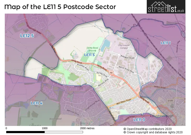
The LE11 5 postcode sector stands on the Leicestershire and Nottinghamshire border.
Did you know? According to the 2021 Census, the LE11 5 postcode sector is home to a bustling 10,759 residents!
Given that each sector allows for 400 unique postcode combinations. Letters C, I, K, M, O and V are not allowed in the last two letters of a postcode. With 216 postcodes already in use, this leaves 184 units available.
The LE11 5 postal code covers the settlement of LOUGHBOROUGH.
The LE11 5 Postcode shares a border with LE11 2 (LOUGHBOROUGH), LE11 3 (LOUGHBOROUGH, Nanpantan), LE12 5 (Hathern, Sutton Bonington, Burton-on-the-Wolds), LE11 1 (LOUGHBOROUGH) and LE11 4 (LOUGHBOROUGH).
The sector is within the post town of LOUGHBOROUGH.
LE11 5 is a postcode sector within the LE11 postcode district which is within the LE Leicester postcode area.
The Royal Mail delivery office for the LE11 5 postal sector is the Loughborough Delivery Office.
The area of the LE11 5 postcode sector is 1.84 square miles which is 4.76 square kilometres or 1,176.35 square acres.
Waterways within the LE11 5 postcode sector include the Loughborough Wharf, Grand Union Canal, River Soar, Black Brook.

Map of the LE11 5 Postcode Sector
Explore the LE11 5 postcode sector by using our free interactive map.
| L | E | 1 | 1 | - | 5 | X | X |
| L | E | 1 | 1 | Space | 5 | Letter | Letter |
Official List of Streets
LOUGHBOROUGH (147 Streets)
Unofficial Streets or Alternative Spellings
LOUGHBOROUGH
ASHBY ROAD BELTON ROAD BIGGIN STREET BOTTLEACRE LANE BRIDGE STREET BRUSH DRIVE CANAL BANK EDWARD STREET EPINAL WAY FREDERICK STREET GRANGE STREET HERRIOT WAY MARKET PLACE MARKET STREET MATTHEW ARNOLD COURT SHAKESPEARE STREET WESLEY CLOSE ALAN MOSS ROAD ROUNDABOUT BEAUMONT COURT BISHOP MEADOW BRIDGE BLACK BROOK WAY BOWLER WAY CRICKETERS DRIVE CUMBERLAND INDUSTRIAL ESTATE DISHLEY WAY ELLABY ROAD GEORGE YARD GORSE COVERT HILL HARLEIGH CLOSE HATHERN DRIVE HAVELOCK CL PEAR TREE LANE PEAR TREE WAY REGENT COURT ROSEBERRY WAY SAINT MARYS CLOSE SCRIVENERS WAY SHARTER CLOSE STONEBOW WALK THE LOCKS WARWICK WAY WARWICK WAY ROUNDABOUT WRITERS WAYWeather Forecast for LE11 5
Press Button to Show Forecast for Loughborough
| Time Period | Icon | Description | Temperature | Rain Probability | Wind |
|---|---|---|---|---|---|
| 18:00 to 21:00 | Cloudy | 8.0°C (feels like 7.0°C) | 6.00% | NE 4 mph | |
| 21:00 to 00:00 | Partly cloudy (night) | 5.0°C (feels like 3.0°C) | 3.00% | E 4 mph |
Press Button to Show Forecast for Loughborough
| Time Period | Icon | Description | Temperature | Rain Probability | Wind |
|---|---|---|---|---|---|
| 00:00 to 03:00 | Partly cloudy (night) | 3.0°C (feels like 1.0°C) | 2.00% | ENE 4 mph | |
| 03:00 to 06:00 | Partly cloudy (night) | 2.0°C (feels like 0.0°C) | 1.00% | NE 2 mph | |
| 06:00 to 09:00 | Sunny day | 2.0°C (feels like 1.0°C) | 1.00% | NE 4 mph | |
| 09:00 to 12:00 | Partly cloudy (day) | 7.0°C (feels like 5.0°C) | 1.00% | NE 7 mph | |
| 12:00 to 15:00 | Cloudy | 9.0°C (feels like 8.0°C) | 10.00% | NE 4 mph | |
| 15:00 to 18:00 | Overcast | 10.0°C (feels like 9.0°C) | 11.00% | NE 4 mph | |
| 18:00 to 21:00 | Cloudy | 8.0°C (feels like 6.0°C) | 9.00% | ENE 7 mph | |
| 21:00 to 00:00 | Partly cloudy (night) | 5.0°C (feels like 3.0°C) | 6.00% | ENE 7 mph |
Press Button to Show Forecast for Loughborough
| Time Period | Icon | Description | Temperature | Rain Probability | Wind |
|---|---|---|---|---|---|
| 00:00 to 03:00 | Partly cloudy (night) | 4.0°C (feels like 2.0°C) | 7.00% | ENE 4 mph | |
| 03:00 to 06:00 | Cloudy | 3.0°C (feels like 1.0°C) | 12.00% | NE 4 mph | |
| 06:00 to 09:00 | Cloudy | 4.0°C (feels like 2.0°C) | 11.00% | NE 7 mph | |
| 09:00 to 12:00 | Cloudy | 8.0°C (feels like 6.0°C) | 12.00% | ENE 9 mph | |
| 12:00 to 15:00 | Overcast | 10.0°C (feels like 8.0°C) | 21.00% | ENE 9 mph | |
| 15:00 to 18:00 | Overcast | 11.0°C (feels like 8.0°C) | 21.00% | ENE 11 mph | |
| 18:00 to 21:00 | Cloudy | 10.0°C (feels like 7.0°C) | 17.00% | ENE 11 mph | |
| 21:00 to 00:00 | Cloudy | 7.0°C (feels like 4.0°C) | 16.00% | NE 11 mph |
Press Button to Show Forecast for Loughborough
| Time Period | Icon | Description | Temperature | Rain Probability | Wind |
|---|---|---|---|---|---|
| 00:00 to 03:00 | Overcast | 7.0°C (feels like 4.0°C) | 21.00% | NE 11 mph | |
| 03:00 to 06:00 | Light rain | 7.0°C (feels like 4.0°C) | 54.00% | NE 13 mph | |
| 06:00 to 09:00 | Heavy rain | 7.0°C (feels like 4.0°C) | 78.00% | NE 13 mph | |
| 09:00 to 12:00 | Heavy rain | 9.0°C (feels like 6.0°C) | 78.00% | NE 11 mph | |
| 12:00 to 15:00 | Heavy rain | 10.0°C (feels like 8.0°C) | 73.00% | NE 11 mph | |
| 15:00 to 18:00 | Light rain shower (day) | 11.0°C (feels like 8.0°C) | 42.00% | NNE 11 mph | |
| 18:00 to 21:00 | Light rain shower (day) | 10.0°C (feels like 8.0°C) | 38.00% | NNE 9 mph | |
| 21:00 to 00:00 | Overcast | 8.0°C (feels like 6.0°C) | 14.00% | S 7 mph |
Schools and Places of Education Within the LE11 5 Postcode Sector
Robert Bakewell Primary School
Academy converter
Barsby Drive, Loughborough, Leicestershire, LE11 5UJ
Head: Mr Jon Bishop
Ofsted Rating: Good
Inspection: 2022-10-05 (568 days ago)
Website: Visit Robert Bakewell Primary School Website
Phone: 01509231646
Number of Pupils: 283
Saint Mary's Catholic Primary School, Loughborough
Academy converter
Hastings Street, Loughborough, Leicestershire, LE11 5AX
Head: Miss Priscilla Jordan
Ofsted Rating: Good
Inspection: 2022-03-30 (757 days ago)
Website: Visit Saint Mary's Catholic Primary School, Loughborough Website
Phone: 01509212621
Number of Pupils: 195
House Prices in the LE11 5 Postcode Sector
| Type of Property | 2018 Average | 2018 Sales | 2017 Average | 2017 Sales | 2016 Average | 2016 Sales | 2015 Average | 2015 Sales |
|---|---|---|---|---|---|---|---|---|
| Detached | £219,963 | 15 | £220,705 | 22 | £225,295 | 35 | £210,165 | 21 |
| Semi-Detached | £174,757 | 73 | £163,290 | 48 | £157,374 | 47 | £150,368 | 45 |
| Terraced | £148,764 | 51 | £166,463 | 56 | £142,530 | 72 | £135,535 | 68 |
| Flats | £122,200 | 17 | £95,029 | 17 | £108,858 | 18 | £104,235 | 17 |
Important Postcodes LE11 5 in the Postcode Sector
LE11 5AX is the postcode for St. Marys RC School, Hastings Street
LE11 5BA is the postcode for Loughborough Child & Family Centre, Regent Street, and BLOCK A, Huntingdon Court, Regent Street
LE11 5BL is the postcode for The Bell Foundry, 20 Swan Street
LE11 5JY is the postcode for Phase 1, Loughborough Hospital,, Hospital Way,, Loughborough Hospital, Hospital Way, PHASE 2, Leicestershire Partnership NHS Trust, Loughborough Hospital, Leicestershire Partnership NHS Trust, Loughborough Hospital, PHASE 1, Leicestershire Partnership NHS Trust, Loughborough Hospital, and Phase 2, Loughborough Hospital,, Hospital Way,
LE11 5UJ is the postcode for BLOCKA A, B, C, Robert Bakewell Primary School, Barsby Drive, MODULAR CLASSROOMS, Robert Bakewell Primary School, Barsby Drive, and Robert Bakewell Primary School, Barsby Drive
| The LE11 5 Sector is within these Local Authorities |
|
|---|---|
| The LE11 5 Sector is within these Counties |
|
| The LE11 5 Sector is within these Water Company Areas |
|