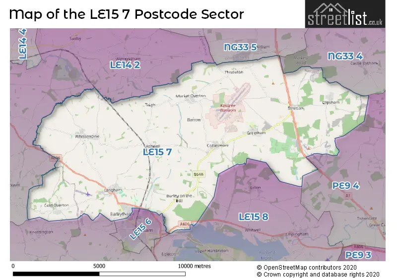
The LE15 7 postcode sector lies where the three counties of Leicestershire, Rutland, and Lincolnshire meet.
Did you know? According to the 2021 Census, the LE15 7 postcode sector is home to a bustling 11,488 residents!
Given that each sector allows for 400 unique postcode combinations. Letters C, I, K, M, O and V are not allowed in the last two letters of a postcode. With 319 postcodes already in use, this leaves 81 units available.
The largest settlement in the LE15 7 postal code is Barleythorpe followed by Cottesmore, and Langham.
The LE15 7 Postcode shares a border with LE14 2 (Wymondham, Frisby On The Wreake, Great Dalby), LE15 8 (Empingham, Edith Weston, North Luffenham), NG33 4 (Corby Glen, Castle Bytham, Ropsley), NG33 5 (Colsterworth, South Witham, Great Ponton), PE9 4 (Tallington, Ryhall, Great Casterton) and LE15 6 (OAKHAM).
The sector is within the post town of OAKHAM.
LE15 7 is a postcode sector within the LE15 postcode district which is within the LE Leicester postcode area.
The Royal Mail delivery office for the LE15 7 postal sector is the Oakham Delivery Office.
The area of the LE15 7 postcode sector is 47.11 square miles which is 122.01 square kilometres or 30,150.09 square acres.
The LE15 7 postcode sector is crossed by the A1 Major A road.
Waterways within the LE15 7 postcode sector include the Oakham Canal.

Map of the LE15 7 Postcode Sector
Explore the LE15 7 postcode sector by using our free interactive map.
| L | E | 1 | 5 | - | 7 | X | X |
| L | E | 1 | 5 | Space | 7 | Letter | Letter |
Official List of Streets
Barleythorpe (52 Streets)
Ashwell (13 Streets)
OAKHAM (6 Streets)
Cottesmore (51 Streets)
Langham (28 Streets)
Whissendine (23 Streets)
Greetham (20 Streets)
Market Overton (18 Streets)
Clipsham (6 Streets)
Stretton (15 Streets)
Burley (10 Streets)
Cold Overton (4 Streets)
Barrow (2 Streets)
Teigh (3 Streets)
Unofficial Streets or Alternative Spellings
Castle Bytham
CLIPSHAM ROADColsterworth
GREAT NORTH ROADOAKHAM
BURLEY PARK WAY LANDS END WAY STAMFORD ROADSouth Witham
THISTLETON LANEStapleford
STAPLEFORD ROADLeesthorpe
OAKHAM ROAD WHISSENDINE ROADPickwell
STYGATE LANESomerby
OAKHAM ROADWeather Forecast for LE15 7
Press Button to Show Forecast for Cottesmore
| Time Period | Icon | Description | Temperature | Rain Probability | Wind |
|---|---|---|---|---|---|
| 12:00 to 15:00 | Overcast | 8.0°C (feels like 4.0°C) | 8.00% | NNW 13 mph | |
| 15:00 to 18:00 | Cloudy | 9.0°C (feels like 6.0°C) | 5.00% | NNW 11 mph | |
| 18:00 to 21:00 | Cloudy | 8.0°C (feels like 6.0°C) | 5.00% | N 7 mph | |
| 21:00 to 00:00 | Partly cloudy (night) | 4.0°C (feels like 2.0°C) | 1.00% | E 4 mph |
Press Button to Show Forecast for Cottesmore
| Time Period | Icon | Description | Temperature | Rain Probability | Wind |
|---|---|---|---|---|---|
| 00:00 to 03:00 | Cloudy | 3.0°C (feels like 0.0°C) | 4.00% | WSW 7 mph | |
| 03:00 to 06:00 | Cloudy | 3.0°C (feels like 0.0°C) | 5.00% | W 7 mph | |
| 06:00 to 09:00 | Cloudy | 4.0°C (feels like 0.0°C) | 5.00% | W 11 mph | |
| 09:00 to 12:00 | Cloudy | 7.0°C (feels like 4.0°C) | 11.00% | WNW 11 mph | |
| 12:00 to 15:00 | Cloudy | 9.0°C (feels like 6.0°C) | 13.00% | NW 11 mph | |
| 15:00 to 18:00 | Cloudy | 9.0°C (feels like 6.0°C) | 10.00% | NNW 9 mph | |
| 18:00 to 21:00 | Cloudy | 7.0°C (feels like 5.0°C) | 8.00% | N 7 mph | |
| 21:00 to 00:00 | Partly cloudy (night) | 4.0°C (feels like 2.0°C) | 1.00% | NNE 4 mph |
Press Button to Show Forecast for Cottesmore
| Time Period | Icon | Description | Temperature | Rain Probability | Wind |
|---|---|---|---|---|---|
| 00:00 to 03:00 | Partly cloudy (night) | 2.0°C (feels like 0.0°C) | 2.00% | NE 4 mph | |
| 03:00 to 06:00 | Cloudy | 1.0°C (feels like -1.0°C) | 4.00% | NE 4 mph | |
| 06:00 to 09:00 | Cloudy | 3.0°C (feels like 0.0°C) | 6.00% | NE 4 mph | |
| 09:00 to 12:00 | Cloudy | 6.0°C (feels like 4.0°C) | 7.00% | ENE 7 mph | |
| 12:00 to 15:00 | Overcast | 9.0°C (feels like 7.0°C) | 15.00% | E 7 mph | |
| 15:00 to 18:00 | Overcast | 9.0°C (feels like 7.0°C) | 17.00% | ESE 9 mph | |
| 18:00 to 21:00 | Overcast | 8.0°C (feels like 6.0°C) | 17.00% | E 9 mph | |
| 21:00 to 00:00 | Cloudy | 6.0°C (feels like 3.0°C) | 14.00% | E 9 mph |
Press Button to Show Forecast for Cottesmore
| Time Period | Icon | Description | Temperature | Rain Probability | Wind |
|---|---|---|---|---|---|
| 00:00 to 03:00 | Cloudy | 5.0°C (feels like 2.0°C) | 19.00% | E 9 mph | |
| 03:00 to 06:00 | Cloudy | 5.0°C (feels like 2.0°C) | 20.00% | E 9 mph | |
| 06:00 to 09:00 | Cloudy | 5.0°C (feels like 2.0°C) | 19.00% | E 9 mph | |
| 09:00 to 12:00 | Overcast | 8.0°C (feels like 5.0°C) | 18.00% | E 9 mph | |
| 12:00 to 15:00 | Cloudy | 11.0°C (feels like 8.0°C) | 20.00% | ESE 11 mph | |
| 15:00 to 18:00 | Light rain shower (day) | 11.0°C (feels like 8.0°C) | 37.00% | ESE 11 mph | |
| 18:00 to 21:00 | Cloudy | 10.0°C (feels like 7.0°C) | 16.00% | NE 11 mph | |
| 21:00 to 00:00 | Cloudy | 8.0°C (feels like 5.0°C) | 16.00% | E 11 mph |
Schools and Places of Education Within the LE15 7 Postcode Sector
Cottesmore Academy
Academy sponsor led
Kendrew Barracks, Oakham, Rutland, LE15 7BA
Head: Mrs Megan Lucas
Ofsted Rating: Good
Inspection: 2022-05-25 (700 days ago)
Website: Visit Cottesmore Academy Website
Phone: 01572812278
Number of Pupils: 138
Langham CofE (Controlled) Primary School
Academy converter
1 Burley Road, Oakham, Rutland, LE15 7HY
Head: Mrs Diane Rowland
Ofsted Rating: Good
Inspection: 2023-05-17 (343 days ago)
Website: Visit Langham CofE (Controlled) Primary School Website
Phone: 01572722676
Number of Pupils: 200
St Nicholas Church of England Primary School
Academy converter
Mill Lane, Oakham, Rutland, LE15 7DL
Head: Mr Daniel Alfieri
Ofsted Rating: Good
Inspection: 2023-01-19 (461 days ago)
Website: Visit St Nicholas Church of England Primary School Website
Phone: 01572812337
Number of Pupils: 126
The Shires
Other independent special school
Shires Lane, , Rutland, LE15 7GT
Head: Mr Jamie Hill
Ofsted Rating: Good
Inspection: 2019-07-04 (1756 days ago)
Website: Visit The Shires Website
Phone: 01780411944
Number of Pupils: 21
House Prices in the LE15 7 Postcode Sector
| Type of Property | 2018 Average | 2018 Sales | 2017 Average | 2017 Sales | 2016 Average | 2016 Sales | 2015 Average | 2015 Sales |
|---|---|---|---|---|---|---|---|---|
| Detached | £398,571 | 86 | £362,327 | 102 | £340,500 | 145 | £344,961 | 148 |
| Semi-Detached | £264,669 | 54 | £225,498 | 65 | £229,574 | 53 | £219,634 | 51 |
| Terraced | £254,326 | 38 | £204,830 | 68 | £249,619 | 81 | £204,746 | 64 |
| Flats | £168,681 | 11 | £183,821 | 17 | £149,815 | 31 | £135,399 | 15 |
Important Postcodes LE15 7 in the Postcode Sector
LE15 7BA is the postcode for The Cottesmore Academy, Cottesmore, and COTTESMORE ACADEMY, KENDREW BARRACKS, SCHOOL ROAD
LE15 7BL is the postcode for BLD 039 AMENITIES CENTRE, Royal Air Force, Cottesmore, Cottesmore Primary School, Cottesmore, BLD 135 BOWLING ALLEY, Royal Air Force, Cottesmore, and BLD 045 GYMNASIUM, Royal Air Force, Cottesmore
LE15 7DL is the postcode for St. Nicholas C of E Primary School, Mill Lane
LE15 7ET is the postcode for Whissendine Primary School, Main Street
LE15 7HY is the postcode for LANGHAM CHURCH OF ENGLAND PRIMARY SCHOOL, BURLEY ROAD, LANGHAM, Langham C of E Primary School, Burley Road, and Langham Church Of England Primary School, Burley Road
LE15 7LF is the postcode for H M Prison, Ashwell Road
LE15 7RD is the postcode for GATEHOUSE/RECEPTION/OFFICES/VISITS HALL, H M Prison, Stocken Hall Road, and H M Prison, Stocken Hall Road
LE15 7TU is the postcode for Active Rutland Hub, Unit 19a, Oakham Enterprise Park, Ashwell Road, and GROUND FLOOR OFFICES, Unit 16a, Oakham Enterprise Park
| The LE15 7 Sector is within these Local Authorities |
|
|---|---|
| The LE15 7 Sector is within these Counties |
|
| The LE15 7 Sector is within these Water Company Areas |
|