The LE19 2 postcode sector is within the county of Leicestershire.
Did you know? According to the 2021 Census, the LE19 2 postcode sector is home to a bustling 6,252 residents!
Given that each sector allows for 400 unique postcode combinations. Letters C, I, K, M, O and V are not allowed in the last two letters of a postcode. With 151 postcodes already in use, this leaves 249 units available.
The largest settlement in the LE19 2 postal code is Narborough followed by Enderby, and Littlethorpe.
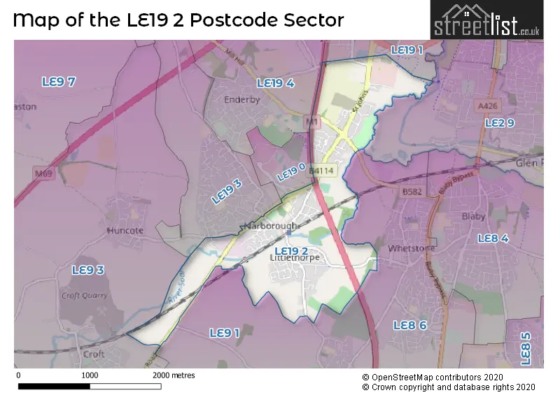
The LE19 2 Postcode shares a border with LE2 9 (LEICESTER, Glen Parva), LE8 6 (Whetstone, Willoughby Waterleys), LE19 3 (Narborough), LE9 1 (Cosby), LE9 3 (Huncote, Croft, Potters Marston), LE19 1 (Meridian Business Park, Enderby, LEICESTER) and LE19 4 (Enderby, Lubbesthorpe).
The sector is within the post town of LEICESTER.
LE19 2 is a postcode sector within the LE19 postcode district which is within the LE Leicester postcode area.
The Royal Mail delivery office for the LE19 2 postal sector is the Swan House Delivery Office.
The area of the LE19 2 postcode sector is 1.91 square miles which is 4.96 square kilometres or 1,225.43 square acres.
The LE19 2 postcode sector is crossed by the M1 motorway.
Waterways within the LE19 2 postcode sector include the River Soar, River Sence.

Map of the LE19 2 Postcode Sector
Explore the LE19 2 postcode sector by using our free interactive map.
| L | E | 1 | 9 | - | 2 | X | X |
| L | E | 1 | 9 | Space | 2 | Letter | Letter |
Official List of Streets
Enderby (26 Streets)
Narborough (40 Streets)
Littlethorpe (38 Streets)
Unofficial Streets or Alternative Spellings
Enderby
SMITH WAY FOSS WAY FOXHUNTER ROUNDABOUT GRASS PATH GUTHLAXTON GAP HILL VIEW KING EDWARD AVENUE LANGHAM BRIDGE LEICESTER LANE LINNETT CLOSE MARIONS WAYBlaby
ENDERBY ROADNarborough
CARLTON PARK HARDWICKE ROAD HUNCOTE ROAD MADDOCK CLOSELEICESTER
NARBOROUGH ROAD SOUTHCosby
CROFT ROAD NARBOROUGH ROADBroughton Astley
COVENTRY ROADWeather Forecast for LE19 2
Press Button to Show Forecast for Glen Parva
| Time Period | Icon | Description | Temperature | Rain Probability | Wind |
|---|---|---|---|---|---|
| 09:00 to 12:00 | Cloudy | 9.0°C (feels like 5.0°C) | 8.00% | NW 18 mph | |
| 12:00 to 15:00 | Cloudy | 10.0°C (feels like 7.0°C) | 13.00% | NNW 13 mph | |
| 15:00 to 18:00 | Cloudy | 11.0°C (feels like 8.0°C) | 7.00% | NNW 13 mph | |
| 18:00 to 21:00 | Partly cloudy (day) | 9.0°C (feels like 6.0°C) | 34.00% | NW 9 mph | |
| 21:00 to 00:00 | Clear night | 6.0°C (feels like 3.0°C) | 2.00% | NW 9 mph |
Press Button to Show Forecast for Glen Parva
| Time Period | Icon | Description | Temperature | Rain Probability | Wind |
|---|---|---|---|---|---|
| 00:00 to 03:00 | Cloudy | 5.0°C (feels like 2.0°C) | 14.00% | WNW 11 mph | |
| 03:00 to 06:00 | Partly cloudy (night) | 4.0°C (feels like 0.0°C) | 2.00% | WNW 11 mph | |
| 06:00 to 09:00 | Sunny day | 4.0°C (feels like 0.0°C) | 2.00% | NW 11 mph | |
| 09:00 to 12:00 | Partly cloudy (day) | 7.0°C (feels like 4.0°C) | 8.00% | NW 13 mph | |
| 12:00 to 15:00 | Cloudy | 9.0°C (feels like 6.0°C) | 11.00% | NW 16 mph | |
| 15:00 to 18:00 | Light rain shower (day) | 9.0°C (feels like 6.0°C) | 30.00% | NW 13 mph | |
| 18:00 to 21:00 | Cloudy | 8.0°C (feels like 5.0°C) | 11.00% | NNW 11 mph | |
| 21:00 to 00:00 | Cloudy | 6.0°C (feels like 3.0°C) | 7.00% | NNW 9 mph |
Press Button to Show Forecast for Glen Parva
| Time Period | Icon | Description | Temperature | Rain Probability | Wind |
|---|---|---|---|---|---|
| 00:00 to 03:00 | Partly cloudy (night) | 4.0°C (feels like 2.0°C) | 3.00% | NNW 7 mph | |
| 03:00 to 06:00 | Clear night | 3.0°C (feels like 1.0°C) | 4.00% | NNW 4 mph | |
| 06:00 to 09:00 | Partly cloudy (day) | 3.0°C (feels like 1.0°C) | 4.00% | NNW 4 mph | |
| 09:00 to 12:00 | Partly cloudy (day) | 8.0°C (feels like 6.0°C) | 4.00% | NNW 7 mph | |
| 12:00 to 15:00 | Overcast | 10.0°C (feels like 8.0°C) | 11.00% | WNW 7 mph | |
| 15:00 to 18:00 | Cloudy | 11.0°C (feels like 10.0°C) | 10.00% | W 9 mph | |
| 18:00 to 21:00 | Cloudy | 11.0°C (feels like 9.0°C) | 12.00% | W 9 mph | |
| 21:00 to 00:00 | Cloudy | 8.0°C (feels like 6.0°C) | 15.00% | W 9 mph |
Press Button to Show Forecast for Glen Parva
| Time Period | Icon | Description | Temperature | Rain Probability | Wind |
|---|---|---|---|---|---|
| 00:00 to 03:00 | Cloudy | 8.0°C (feels like 5.0°C) | 13.00% | W 11 mph | |
| 03:00 to 06:00 | Overcast | 8.0°C (feels like 5.0°C) | 10.00% | W 11 mph | |
| 06:00 to 09:00 | Cloudy | 8.0°C (feels like 5.0°C) | 5.00% | WNW 13 mph | |
| 09:00 to 12:00 | Cloudy | 10.0°C (feels like 7.0°C) | 8.00% | WNW 16 mph | |
| 12:00 to 15:00 | Cloudy | 12.0°C (feels like 9.0°C) | 8.00% | NW 18 mph | |
| 15:00 to 18:00 | Cloudy | 13.0°C (feels like 9.0°C) | 8.00% | NW 18 mph | |
| 18:00 to 21:00 | Partly cloudy (day) | 11.0°C (feels like 9.0°C) | 4.00% | NNW 13 mph | |
| 21:00 to 00:00 | Clear night | 9.0°C (feels like 7.0°C) | 4.00% | N 7 mph |
Schools and Places of Education Within the LE19 2 Postcode Sector
Greystoke Primary School
Academy converter
Thornton Drive, Leicester, Leicestershire, LE19 2GX
Head: Mrs Sharon Richardson
Ofsted Rating: Good
Inspection: 2023-05-24 (328 days ago)
Website: Visit Greystoke Primary School Website
Phone: 01162862286
Number of Pupils: 358
House Prices in the LE19 2 Postcode Sector
| Type of Property | 2018 Average | 2018 Sales | 2017 Average | 2017 Sales | 2016 Average | 2016 Sales | 2015 Average | 2015 Sales |
|---|---|---|---|---|---|---|---|---|
| Detached | £300,377 | 41 | £288,762 | 49 | £290,615 | 47 | £268,124 | 51 |
| Semi-Detached | £212,115 | 37 | £179,972 | 39 | £177,120 | 41 | £179,642 | 30 |
| Terraced | £175,966 | 32 | £179,235 | 32 | £166,363 | 38 | £144,755 | 49 |
| Flats | £135,975 | 2 | £165,333 | 3 | £141,900 | 5 | £138,242 | 6 |
Important Postcodes LE19 2 in the Postcode Sector
LE19 2BX is the postcode for LEARNING AND DEVELOPMENT, Leicestershire Constabulary, St. Johns, AMENITIES, Leicestershire Constabulary, St. Johns, and ADMINISTRATION 1, Leicestershire Constabulary, St. Johns
LE19 2DU is the postcode for Limes Medical Centre, 65 Leicester Road
LE19 2EP is the postcode for Blaby District Council, Desford Road, and Blaby District Council, Council Offices, Desford Road
LE19 2GX is the postcode for Narborough Health Centre, Thornton Drive, Greystoke Cp School, Thornton Drive, Narborough, BLOCK ABF, Greystoke Cp School, Thornton Drive, and Greystoke Cp School, Thornton Drive
| The LE19 2 Sector is within these Local Authorities |
|
|---|---|
| The LE19 2 Sector is within these Counties |
|
| The LE19 2 Sector is within these Water Company Areas |
|