The LE6 postcode district is a postal district located in the LE Leicester postcode area with a population of 12,048 residents according to the 2021 England and Wales Census.
The area of the LE6 postcode district is 10.45 square miles which is 27.06 square kilometres or 6,687.47 acres.
Currently, the LE6 district has about 250 postcode units spread across 11 geographic postcode sectors.
Given that each sector allows for 400 unique postcode combinations, the district has a capacity of 4,400 postcodes. With 250 postcodes already in use, this leaves 4150 units available.
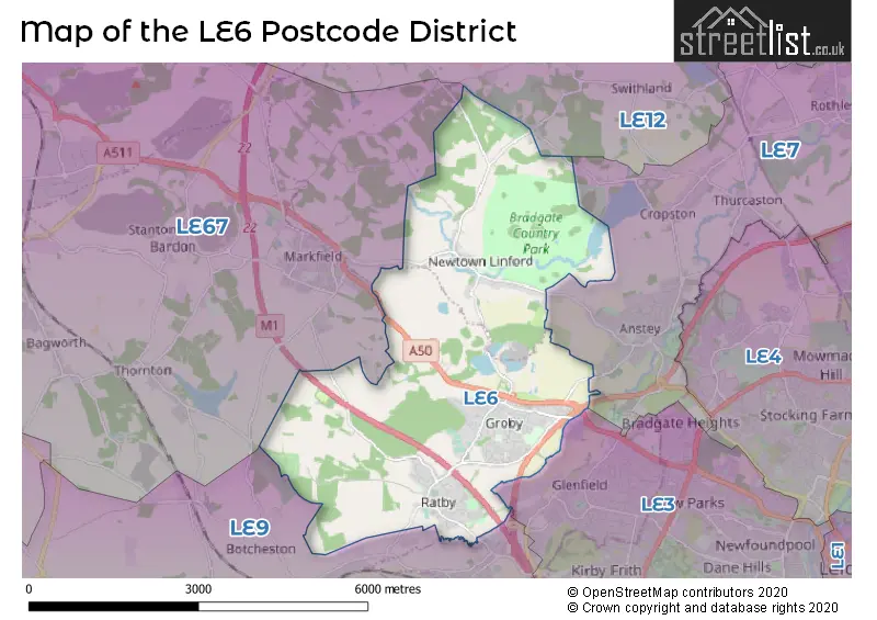
The largest settlement in the LE6 postal code is Groby followed by Ratby, and Newtown Linford.
The LE6 Postcode shares a border with LE67 (COALVILLE, Whitwick, IBSTOCK), LE9 (Earl Shilton, Barwell, Broughton Astley), LE3 (LEICESTER, Glenfield, Leicester Forest East) and LE7 (Syston, Anstey, Rothley).
The primary settlement in the LE6 postcode district is Leicester, located in the county of Leicestershire, England. Additionally, significant settlements in this postcode district include Groby, Newtown Linford, and Ratby, all also located in Leicestershire. The main post town for the LE6 postcode district is Leicester.
For the district LE6, we have data on 1 postcode sectors. Here's a breakdown: The sector LE6 0, covers Groby and Ratby in Leicestershire.


Map of the LE6 Postcode District
Explore the LE6 postcode district by using our free interactive map.
When it comes to local government, postal geography often disregards political borders. However, for a breakdown in the LE6 District: the district mostly encompasses the Hinckley and Bosworth District (B) (234 postcodes), and finally, the Charnwood District (B) area (18 postcodes).
Recent House Sales in LE67
| Date | Price | Address |
|---|---|---|
| 27/10/2023 | £290,000 | London Road, Coalville, LE67 3JD |
| 26/10/2023 | £440,000 | Beesley Lane, Ravenstone, Coalville, LE67 2EP |
| 24/10/2023 | £270,000 | St Davids Crescent, Coalville, LE67 4ST |
| 29/09/2023 | £204,436 | Devana Avenue, Coalville, LE67 4BQ |
| 29/09/2023 | £425,000 | Willow Woods Close, Newbold Coleorton, Coalville, LE67 8AR |
| 29/09/2023 | £330,000 | Spring Lane, Swannington, Coalville, LE67 8QQ |
| 28/09/2023 | £252,000 | Staples Drive, Coalville, LE67 4GB |
| 26/09/2023 | £265,000 | Jackson Road, Bagworth, Coalville, LE67 1HL |
| 25/09/2023 | £265,000 | Castle Rock Drive, Coalville, LE67 4SE |
| 22/09/2023 | £285,000 | Argyle Street, Ibstock, LE67 6NB |
Weather Forecast for LE6
Press Button to Show Forecast for Glenfield
| Time Period | Icon | Description | Temperature | Rain Probability | Wind |
|---|---|---|---|---|---|
| 03:00 to 06:00 | Cloudy | 9.0°C (feels like 6.0°C) | 51.00% | WNW 13 mph | |
| 06:00 to 09:00 | Cloudy | 8.0°C (feels like 5.0°C) | 15.00% | WNW 13 mph | |
| 09:00 to 12:00 | Light rain shower (day) | 9.0°C (feels like 6.0°C) | 37.00% | NW 16 mph | |
| 12:00 to 15:00 | Light rain shower (day) | 11.0°C (feels like 8.0°C) | 36.00% | NW 13 mph | |
| 15:00 to 18:00 | Cloudy | 11.0°C (feels like 8.0°C) | 32.00% | N 13 mph | |
| 18:00 to 21:00 | Overcast | 9.0°C (feels like 7.0°C) | 10.00% | N 9 mph | |
| 21:00 to 00:00 | Partly cloudy (night) | 7.0°C (feels like 4.0°C) | 2.00% | NNE 7 mph |
Press Button to Show Forecast for Glenfield
| Time Period | Icon | Description | Temperature | Rain Probability | Wind |
|---|---|---|---|---|---|
| 00:00 to 03:00 | Cloudy | 5.0°C (feels like 3.0°C) | 4.00% | N 7 mph | |
| 03:00 to 06:00 | Cloudy | 4.0°C (feels like 1.0°C) | 4.00% | NNW 7 mph | |
| 06:00 to 09:00 | Cloudy | 4.0°C (feels like 1.0°C) | 8.00% | NNW 7 mph | |
| 09:00 to 12:00 | Cloudy | 6.0°C (feels like 3.0°C) | 5.00% | N 9 mph | |
| 12:00 to 15:00 | Overcast | 9.0°C (feels like 6.0°C) | 8.00% | N 9 mph | |
| 15:00 to 18:00 | Overcast | 10.0°C (feels like 8.0°C) | 8.00% | N 9 mph | |
| 18:00 to 21:00 | Cloudy | 9.0°C (feels like 7.0°C) | 5.00% | NNE 7 mph | |
| 21:00 to 00:00 | Partly cloudy (night) | 7.0°C (feels like 5.0°C) | 2.00% | ENE 4 mph |
Press Button to Show Forecast for Glenfield
| Time Period | Icon | Description | Temperature | Rain Probability | Wind |
|---|---|---|---|---|---|
| 00:00 to 03:00 | Partly cloudy (night) | 5.0°C (feels like 4.0°C) | 1.00% | N 4 mph | |
| 03:00 to 06:00 | Partly cloudy (night) | 4.0°C (feels like 3.0°C) | 2.00% | NNW 4 mph | |
| 06:00 to 09:00 | Overcast | 5.0°C (feels like 4.0°C) | 9.00% | NNW 4 mph | |
| 09:00 to 12:00 | Cloudy | 7.0°C (feels like 6.0°C) | 9.00% | NNE 7 mph | |
| 12:00 to 15:00 | Overcast | 9.0°C (feels like 7.0°C) | 10.00% | NNE 9 mph | |
| 15:00 to 18:00 | Overcast | 10.0°C (feels like 8.0°C) | 10.00% | NNE 9 mph | |
| 18:00 to 21:00 | Cloudy | 9.0°C (feels like 7.0°C) | 5.00% | NE 9 mph | |
| 21:00 to 00:00 | Partly cloudy (night) | 7.0°C (feels like 4.0°C) | 5.00% | NE 7 mph |
Press Button to Show Forecast for Glenfield
| Time Period | Icon | Description | Temperature | Rain Probability | Wind |
|---|---|---|---|---|---|
| 00:00 to 03:00 | Partly cloudy (night) | 5.0°C (feels like 3.0°C) | 3.00% | NE 7 mph | |
| 03:00 to 06:00 | Cloudy | 4.0°C (feels like 2.0°C) | 6.00% | NNE 7 mph | |
| 06:00 to 09:00 | Cloudy | 4.0°C (feels like 2.0°C) | 6.00% | NNE 7 mph | |
| 09:00 to 12:00 | Cloudy | 8.0°C (feels like 6.0°C) | 7.00% | NE 9 mph | |
| 12:00 to 15:00 | Overcast | 10.0°C (feels like 7.0°C) | 12.00% | NNE 9 mph | |
| 15:00 to 18:00 | Cloudy | 10.0°C (feels like 8.0°C) | 15.00% | NE 11 mph | |
| 18:00 to 21:00 | Cloudy | 9.0°C (feels like 7.0°C) | 8.00% | NE 9 mph | |
| 21:00 to 00:00 | Cloudy | 7.0°C (feels like 4.0°C) | 6.00% | NE 7 mph |
Where is the LE6 Postcode District?
The postcode district LE6 is located in Leicester. It is nearby the towns of Markfield (2.51 miles to the North West), Loughborough (6.61 miles to the North), Ibstock (6.82 miles to the West), Wigston (8.37 miles to the South East), and Hinckley (10.90 miles to the South West). Additionally, Leicester is located approximately 93.34 miles away from the centre of London.
The district is within the post town of LEICESTER.
The sector has postcodes within the nation of England.
The LE6 Postcode District is covers the following regions.
- Leicestershire CC and Rutland - Leicestershire, Rutland and Northamptonshire - East Midlands (England)
- South and West Derbyshire - Derbyshire and Nottinghamshire - East Midlands (England)
Postcode Sectors within the LE6 District
| Postcode Sector | Delivery Office |
|---|---|
| LE6 0 | Groby Scale Payment Delivery Office |
| LE6 0 | Ratby Scale Payment Delivery Office |
| L | E | 6 | - | X | X | X |
| L | E | 6 | Space | Numeric | Letter | Letter |
Current Monthly Rental Prices
| # Bedrooms | Min Price | Max Price | Avg Price |
|---|---|---|---|
| 2 | £850 | £900 | £882 |
| 3 | £895 | £1,750 | £1,348 |
| 4 | £2,300 | £2,300 | £2,300 |
Current House Prices
| # Bedrooms | Min Price | Max Price | Avg Price |
|---|---|---|---|
| £250,000 | £250,000 | £250,000 | |
| 2 | £75,000 | £650,000 | £249,998 |
| 3 | £230,000 | £550,000 | £309,927 |
| 4 | £290,000 | £595,000 | £456,471 |
| 5 | £325,000 | £1,100,000 | £577,142 |
| 6 | £645,000 | £1,900,000 | £1,486,250 |
Estate Agents who Operate in the LE6 District
| Logo | Name | Brand Name | Address | Contact Number | Total Properties |
|---|---|---|---|---|---|
 | Leicester | ANDERSON BRIGGS | 4 Ratby Road, Groby, Leicester, LE6 0GG | 0116 497 6826 | 24 |
 | Leicester | Newby & Co | 88 Faire Road, Glenfield, Leicester, LE3 8ED | 0116 216 3823 | 18 |
 | Leicester Forest East | Newton Fallowell | 18 Hinckley Road, Leicester Forest East, Leicester, LE3 3GH | 0116 366 1554 | 7 |
 | Anstey | Judge Estate Agents | 13 The Nook, Anstey LE7 7AZ | 0116 216 4833 | 4 |
 | Melton Mowbray | Bentons | 47 Nottingham Street Melton Mowbray Leicestershire, LE13 1NN | 01664 494408 | 3 |
| Type of Property | 2018 Average | 2018 Sales | 2017 Average | 2017 Sales | 2016 Average | 2016 Sales | 2015 Average | 2015 Sales |
|---|---|---|---|---|---|---|---|---|
| Detached | £326,698 | 94 | £263,058 | 84 | £270,764 | 105 | £286,472 | 99 |
| Semi-Detached | £200,036 | 66 | £195,096 | 61 | £190,221 | 86 | £179,077 | 46 |
| Terraced | £169,345 | 49 | £158,237 | 42 | £149,448 | 41 | £154,428 | 46 |
| Flats | £101,171 | 7 | £102,488 | 4 | £143,119 | 8 | £115,350 | 5 |