The LE65 postcode district is a postal district located in the LE Leicester postcode area with a population of 16,942 residents according to the 2021 England and Wales Census.
The area of the LE65 postcode district is 17.43 square miles which is 45.15 square kilometres or 11,157.68 acres.
Currently, the LE65 district has about 471 postcode units spread across 2 geographic postcode sectors.
Given that each sector allows for 400 unique postcode combinations, the district has a capacity of 800 postcodes. With 471 postcodes already in use, this leaves 329 units available.
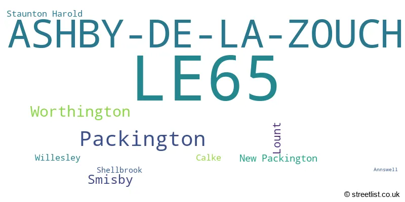
The largest settlement in the LE65 postal code is ASHBY-DE-LA-ZOUCH followed by Packington, and Worthington.
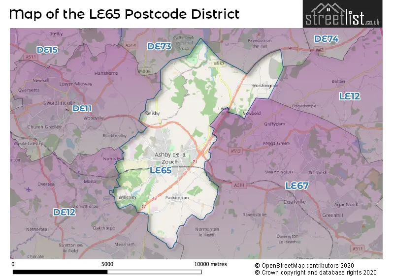
The LE65 Postcode shares a border with DE11 (SWADLINCOTE, Newhall, Woodville), DE12 (Measham, Overseal, Moira), DE73 (Chellaston, Melbourne, Ticknall) and LE67 (COALVILLE, Whitwick, IBSTOCK).
The primary settlement in the LE65 postcode district is Ashby-de-la-Zouch. It is located in the county of Leicestershire in England. Other significant settlements in the district include Calke, Lount, New Packington, Packington, Staunton Harold, and Worthington, all of which are also located in Leicestershire. The most significant post town in this district is Ashby-de-la-Zouch.
For the district LE65, we have data on 3 postcode sectors. Here's a breakdown: The sector LE65 1, covers Ashby-De-La-Zouch and Packington in Leicestershire. The sector LE65 2, covers Ashby-De-La-Zouch in Leicestershire. The sector LE65 9 is non-geographic. It's often designated for PO Boxes, large organisations, or special services.

Map of the LE65 Postcode District
Explore the LE65 postcode district by using our free interactive map.
When it comes to local government, postal geography often disregards political borders. However, for a breakdown in the LE65 District: the district mostly encompasses the North West Leicestershire District (454 postcodes), and finally, the South Derbyshire District area (11 postcodes).
Recent House Sales in LE65
| Date | Price | Address |
|---|---|---|
| 20/10/2023 | £400,000 | Coniston Gardens, Ashby-de-la-zouch, LE65 1FB |
| 20/10/2023 | £495,000 | Burton Road, Ashby-de-la-zouch, LE65 2LG |
| 19/10/2023 | £370,000 | Rowena Drive, Ashby-de-la-zouch, LE65 2JE |
| 05/10/2023 | £380,000 | Tamworth Road, Ashby-de-la-zouch, LE65 2PX |
| 04/10/2023 | £225,000 | Range Road, Ashby-de-la-zouch, LE65 1EB |
| 26/09/2023 | £130,000 | School Lane, Ashby-de-la-zouch, LE65 2RW |
| 20/09/2023 | £260,000 | Tamworth Road, Ashby-de-la-zouch, LE65 2PR |
| 12/09/2023 | £540,000 | Astley Way, Ashby-de-la-zouch, LE65 1LY |
| 31/08/2023 | £185,000 | Ridgway Road, Ashby-de-la-zouch, LE65 2PL |
| 25/08/2023 | £340,000 | Lower Packington Road, Ashby-de-la-zouch, LE65 1GD |
Weather Forecast for LE65
Press Button to Show Forecast for Ashby De La Zouch
| Time Period | Icon | Description | Temperature | Rain Probability | Wind |
|---|---|---|---|---|---|
| 00:00 to 03:00 | Partly cloudy (night) | 3.0°C (feels like 1.0°C) | 2.00% | ENE 4 mph | |
| 03:00 to 06:00 | Partly cloudy (night) | 2.0°C (feels like 0.0°C) | 1.00% | NE 4 mph | |
| 06:00 to 09:00 | Partly cloudy (day) | 2.0°C (feels like 0.0°C) | 4.00% | NE 4 mph | |
| 09:00 to 12:00 | Partly cloudy (day) | 6.0°C (feels like 4.0°C) | 1.00% | ENE 7 mph | |
| 12:00 to 15:00 | Overcast | 9.0°C (feels like 7.0°C) | 10.00% | ENE 4 mph | |
| 15:00 to 18:00 | Cloudy | 9.0°C (feels like 9.0°C) | 7.00% | NE 4 mph | |
| 18:00 to 21:00 | Cloudy | 8.0°C (feels like 6.0°C) | 10.00% | ENE 7 mph | |
| 21:00 to 00:00 | Partly cloudy (night) | 5.0°C (feels like 2.0°C) | 6.00% | ENE 7 mph |
Press Button to Show Forecast for Ashby De La Zouch
| Time Period | Icon | Description | Temperature | Rain Probability | Wind |
|---|---|---|---|---|---|
| 00:00 to 03:00 | Partly cloudy (night) | 3.0°C (feels like 1.0°C) | 7.00% | ENE 4 mph | |
| 03:00 to 06:00 | Cloudy | 3.0°C (feels like 0.0°C) | 12.00% | NE 7 mph | |
| 06:00 to 09:00 | Cloudy | 4.0°C (feels like 1.0°C) | 11.00% | NE 7 mph | |
| 09:00 to 12:00 | Cloudy | 7.0°C (feels like 5.0°C) | 13.00% | ENE 11 mph | |
| 12:00 to 15:00 | Overcast | 9.0°C (feels like 7.0°C) | 22.00% | ENE 9 mph | |
| 15:00 to 18:00 | Cloudy | 10.0°C (feels like 8.0°C) | 19.00% | ENE 11 mph | |
| 18:00 to 21:00 | Cloudy | 9.0°C (feels like 6.0°C) | 18.00% | ENE 11 mph | |
| 21:00 to 00:00 | Cloudy | 7.0°C (feels like 4.0°C) | 19.00% | NE 11 mph |
Press Button to Show Forecast for Ashby De La Zouch
| Time Period | Icon | Description | Temperature | Rain Probability | Wind |
|---|---|---|---|---|---|
| 00:00 to 03:00 | Overcast | 6.0°C (feels like 3.0°C) | 25.00% | NE 11 mph | |
| 03:00 to 06:00 | Light rain | 6.0°C (feels like 3.0°C) | 53.00% | NE 13 mph | |
| 06:00 to 09:00 | Heavy rain | 6.0°C (feels like 3.0°C) | 76.00% | NE 13 mph | |
| 09:00 to 12:00 | Heavy rain | 8.0°C (feels like 5.0°C) | 77.00% | NNE 11 mph | |
| 12:00 to 15:00 | Heavy rain | 9.0°C (feels like 7.0°C) | 73.00% | NE 11 mph | |
| 15:00 to 18:00 | Light rain | 10.0°C (feels like 7.0°C) | 55.00% | NNE 11 mph | |
| 18:00 to 21:00 | Heavy rain shower (day) | 9.0°C (feels like 7.0°C) | 54.00% | NNE 9 mph | |
| 21:00 to 00:00 | Cloudy | 7.0°C (feels like 5.0°C) | 12.00% | S 7 mph |
Where is the LE65 Postcode District?
The data indicates that the postcode district LE65 is located in the town of Ashby-de-la-Zouch. It is centrally located among several nearby towns, including Swadlincote to the west (approx. 3.742 miles away), Coalville to the east (approx. 4.313 miles away), Ibstock to the southeast (approx. 5.380 miles away), Burton-on-Trent to the northwest (approx. 9.206 miles away), Derby to the north (approx. 10.751 miles away), Tamworth to the southwest (approx. 12.348 miles away), and Atherstone to the south (approx. 13.636 miles away). Additionally, the postcode district is approximately 103.275 miles away from the center of London.
The district is within the post town of ASHBY-DE-LA-ZOUCH.
The sector has postcodes within the nation of England.
The LE65 Postcode District is covers the following regions.
- Leicestershire CC and Rutland - Leicestershire, Rutland and Northamptonshire - East Midlands (England)
- South and West Derbyshire - Derbyshire and Nottinghamshire - East Midlands (England)
| Postcode Sector | Delivery Office |
|---|---|
| LE65 1 | Ashby-de-la-zouch Delivery Office |
| LE65 2 | Ashby-de-la-zouch Delivery Office |
| L | E | 6 | 5 | - | X | X | X |
| L | E | 6 | 5 | Space | Numeric | Letter | Letter |
Tourist Attractions within the Postcode Area
We found 1 visitor attractions within the LE65 postcode area
| Ashby de la Zouch Castle |
|---|
| Historic Properties |
| Castle / Fort |
| View Ashby de la Zouch Castle on Google Maps |
Current Monthly Rental Prices
| # Bedrooms | Min Price | Max Price | Avg Price |
|---|---|---|---|
| 1 | £695 | £695 | £695 |
| 2 | £650 | £1,250 | £849 |
| 3 | £925 | £1,400 | £1,255 |
| 4 | £1,450 | £1,450 | £1,450 |
Current House Prices
| # Bedrooms | Min Price | Max Price | Avg Price |
|---|---|---|---|
| 1 | £123,000 | £200,000 | £149,500 |
| 2 | £140,000 | £650,000 | £225,152 |
| 3 | £180,000 | £525,000 | £301,154 |
| 4 | £100,000 | £995,000 | £474,474 |
| 5 | £450,000 | £1,100,000 | £632,308 |
| 6 | £800,000 | £925,000 | £862,500 |
| 13 | £795,000 | £795,000 | £795,000 |
Estate Agents who Operate in the LE65 District
| Logo | Name | Brand Name | Address | Contact Number | Total Properties |
|---|---|---|---|---|---|
 | Ashby-De-La-Zouch | Howkins & Harrison Incorporating Andrew Johnson | 58 Market Street, Ashby-De-La-Zouch, LE65 1AN | 01530 441245 | 22 |
 | Ashby-De-La-Zouch | Newton Fallowell | 6A Bath Street, Ashby-De-La-Zouch, LE65 2FH | 01530 441361 | 20 |
 | Ashby de la Zouch | John German | 63a Market Street, Ashby-De-La-Zouch, LE65 1AH | 01530 567000 | 15 |
 | Ashby-de-la-Zouch | Whiteheads | 8 The Pass Courtyard, Market Street, Ashby De La Zouch LE65 1AG | 01530 441477 | 10 |
 | Ashby De La Zouch | Royston & Lund Estate Agents | 4 Bath Street, Ashby-De-La-Zouch, LE65 2FH | 01538 710655 | 7 |
| Type of Property | 2018 Average | 2018 Sales | 2017 Average | 2017 Sales | 2016 Average | 2016 Sales | 2015 Average | 2015 Sales |
|---|---|---|---|---|---|---|---|---|
| Detached | £359,406 | 248 | £357,169 | 205 | £336,900 | 159 | £314,608 | 215 |
| Semi-Detached | £227,964 | 103 | £224,537 | 80 | £201,904 | 74 | £187,563 | 91 |
| Terraced | £184,050 | 78 | £200,713 | 59 | £170,267 | 49 | £179,982 | 83 |
| Flats | £166,582 | 30 | £165,076 | 44 | £199,215 | 65 | £126,685 | 28 |