The LE7 9 postcode sector stands on the Leicestershire and Rutland border.
Did you know? According to the 2021 Census, the LE7 9 postcode sector is home to a bustling 11,956 residents!
Given that each sector allows for 400 unique postcode combinations. Letters C, I, K, M, O and V are not allowed in the last two letters of a postcode. With 319 postcodes already in use, this leaves 81 units available.
The largest settlement in the LE7 9 postal code is Scraptoft followed by Thurnby, and Houghton-on-the-Hill.
The LE7 9 Postcode shares a border with LE2 2 (LEICESTER, Oadby, Stoughton), LE5 1 (Hamilton, LEICESTER, Humberstone), LE5 2 (LEICESTER), LE5 6 (LEICESTER, Evington), LE7 3 (Queniborough, East Goscote, Barkby), LE7 4 (Rearsby, Thrussington, Cossington), LE8 0 (Kibworth Beauchamp, Kibworth Harcourt, Smeeton Westerby), LE14 2 (Wymondham, Frisby On The Wreake, Great Dalby), LE15 8 (Empingham, Edith Weston, North Luffenham), LE8 9 (Great Glen, Burton Overy, Newton Harcourt), LE15 9 (Uppingham, Belton In Rutland, Lyddington), LE16 7 (MARKET HARBOROUGH, Great Bowden, Foxton) and LE16 8 (MARKET HARBOROUGH, Cottingham, Great Easton).
The sector is within the post town of LEICESTER.
LE7 9 is a postcode sector within the LE7 postcode district which is within the LE Leicester postcode area.
The Royal Mail delivery office for the LE7 9 postal sector is the Leicester East Delivery Office and Billesdelivery Officen Scale Payment Delivery Office and Tilton On The Hill Scale Payment Delivery Office.
The area of the LE7 9 postcode sector is 54.56 square miles which is 141.32 square kilometres or 34,920.25 square acres.

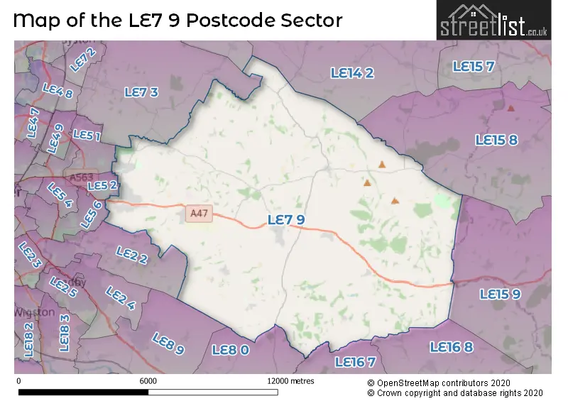
Map of the LE7 9 Postcode Sector
Explore the LE7 9 postcode sector by using our free interactive map.
| L | E | 7 | - | 9 | X | X |
| L | E | 7 | Space | 9 | Letter | Letter |
Official List of Streets
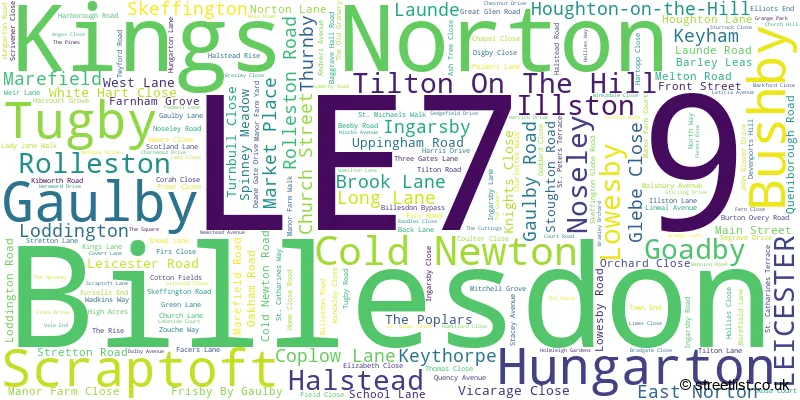
Scraptoft (58 Streets)
Thurnby (43 Streets)
Houghton-on-the-Hill (33 Streets)
Gaulby (7 Streets)
Hungarton (8 Streets)
Bushby (27 Streets)
Billesdon (27 Streets)
Ingarsby (2 Streets)
Illston (7 Streets)
Tugby (8 Streets)
East Norton (4 Streets)
Goadby (3 Streets)
Noseley (1 Streets)
Keythorpe (2 Streets)
Tilton On The Hill (18 Streets)
Kings Norton (3 Streets)
LEICESTER (1 Streets)
Keyham (5 Streets)
Skeffington (4 Streets)
Launde (1 Streets)
Lowesby (3 Streets)
Loddington (1 Streets)
Halstead (1 Streets)
Marefield (2 Streets)
Rolleston (2 Streets)
Unofficial Streets or Alternative Spellings
Tilton On The Hill
HALSTEAD ROADHallaton
GOADBY ROADLEICESTER
THURNCOURT ROADGreat Stretton
GARTREE ROADBeeby
HUNGARTON LANEHamilton
KEYHAM LANE WESTWeather Forecast for LE7 9
Press Button to Show Forecast for Skeffington
| Time Period | Icon | Description | Temperature | Rain Probability | Wind |
|---|---|---|---|---|---|
| 09:00 to 12:00 | Mist | 6.0°C (feels like 3.0°C) | 18.00% | NNW 11 mph | |
| 12:00 to 15:00 | Overcast | 8.0°C (feels like 5.0°C) | 28.00% | N 11 mph | |
| 15:00 to 18:00 | Overcast | 10.0°C (feels like 7.0°C) | 8.00% | N 13 mph | |
| 18:00 to 21:00 | Cloudy | 8.0°C (feels like 5.0°C) | 7.00% | NNE 11 mph | |
| 21:00 to 00:00 | Cloudy | 5.0°C (feels like 3.0°C) | 5.00% | N 7 mph |
Press Button to Show Forecast for Skeffington
| Time Period | Icon | Description | Temperature | Rain Probability | Wind |
|---|---|---|---|---|---|
| 00:00 to 03:00 | Cloudy | 4.0°C (feels like 1.0°C) | 8.00% | N 9 mph | |
| 03:00 to 06:00 | Overcast | 4.0°C (feels like 0.0°C) | 8.00% | NNW 9 mph | |
| 06:00 to 09:00 | Overcast | 4.0°C (feels like 0.0°C) | 9.00% | NNW 9 mph | |
| 09:00 to 12:00 | Overcast | 6.0°C (feels like 2.0°C) | 10.00% | NNW 13 mph | |
| 12:00 to 15:00 | Overcast | 7.0°C (feels like 4.0°C) | 11.00% | NNW 13 mph | |
| 15:00 to 18:00 | Overcast | 8.0°C (feels like 4.0°C) | 10.00% | N 13 mph | |
| 18:00 to 21:00 | Cloudy | 6.0°C (feels like 3.0°C) | 5.00% | N 11 mph | |
| 21:00 to 00:00 | Partly cloudy (night) | 4.0°C (feels like 0.0°C) | 2.00% | N 9 mph |
Press Button to Show Forecast for Skeffington
| Time Period | Icon | Description | Temperature | Rain Probability | Wind |
|---|---|---|---|---|---|
| 00:00 to 03:00 | Cloudy | 2.0°C (feels like -1.0°C) | 6.00% | NNW 9 mph | |
| 03:00 to 06:00 | Cloudy | 2.0°C (feels like -2.0°C) | 5.00% | NW 9 mph | |
| 06:00 to 09:00 | Cloudy | 3.0°C (feels like -1.0°C) | 6.00% | NW 9 mph | |
| 09:00 to 12:00 | Cloudy | 6.0°C (feels like 3.0°C) | 8.00% | NNW 9 mph | |
| 12:00 to 15:00 | Overcast | 8.0°C (feels like 6.0°C) | 11.00% | NNW 9 mph | |
| 15:00 to 18:00 | Overcast | 8.0°C (feels like 6.0°C) | 14.00% | N 9 mph | |
| 18:00 to 21:00 | Cloudy | 8.0°C (feels like 6.0°C) | 10.00% | NNE 7 mph | |
| 21:00 to 00:00 | Cloudy | 5.0°C (feels like 3.0°C) | 6.00% | ESE 7 mph |
Press Button to Show Forecast for Skeffington
| Time Period | Icon | Description | Temperature | Rain Probability | Wind |
|---|---|---|---|---|---|
| 00:00 to 03:00 | Cloudy | 4.0°C (feels like 1.0°C) | 6.00% | ENE 7 mph | |
| 03:00 to 06:00 | Cloudy | 3.0°C (feels like 0.0°C) | 8.00% | NW 7 mph | |
| 06:00 to 09:00 | Cloudy | 4.0°C (feels like 1.0°C) | 8.00% | SE 7 mph | |
| 09:00 to 12:00 | Cloudy | 7.0°C (feels like 5.0°C) | 8.00% | W 7 mph | |
| 12:00 to 15:00 | Cloudy | 9.0°C (feels like 7.0°C) | 11.00% | SSW 9 mph | |
| 15:00 to 18:00 | Cloudy | 10.0°C (feels like 8.0°C) | 13.00% | SSW 7 mph | |
| 18:00 to 21:00 | Cloudy | 9.0°C (feels like 7.0°C) | 11.00% | SW 7 mph | |
| 21:00 to 00:00 | Cloudy | 6.0°C (feels like 4.0°C) | 10.00% | SSE 7 mph |
Schools and Places of Education Within the LE7 9 Postcode Sector
Billesdon Church of England Primary School
Voluntary controlled school
Gaulby Road, Leicester, Leicestershire, LE7 9AG
Head: Mrs Lisa Willcocks
Ofsted Rating: Requires improvement
Inspection: 2023-03-08 (412 days ago)
Website: Visit Billesdon Church of England Primary School Website
Phone: 01162596327
Number of Pupils: 94
Fernvale Primary School
Academy converter
Somerby Road, Leicester, Leicestershire, LE7 9PR
Head: Mrs Helen Cartledge-Splitt
Ofsted Rating: Good
Inspection: 2019-03-06 (1875 days ago)
Website: Visit Fernvale Primary School Website
Phone: 01162416722
Number of Pupils: 317
Houghton-on-the-Hill Church of England Primary School
Academy converter
Main Street, Leicester, Leicestershire, LE7 9GD
Head: Mrs Ali Woollerson
Ofsted Rating: Good
Inspection: 2022-10-05 (566 days ago)
Website: Visit Houghton-on-the-Hill Church of England Primary School Website
Phone: 01162412465
Number of Pupils: 207
Thurnby, St Luke's Church of England Primary School
Academy converter
Main Street, Leicester, Leicestershire, LE7 9PN
Head: Mr Neil Bardsley
Ofsted Rating: Good
Inspection: 2021-10-27 (909 days ago)
Website: Visit Thurnby, St Luke's Church of England Primary School Website
Phone: 01162415105
Number of Pupils: 214
Tugby Church of England Primary School
Academy converter
Main Street, Leicester, Leicestershire, LE7 9WD
Head: Mr Gavin Skye
Ofsted Rating: Good
Inspection: 2020-01-09 (1566 days ago)
Website: Visit Tugby Church of England Primary School Website
Phone: 01162598248
Number of Pupils: 46
House Prices in the LE7 9 Postcode Sector
| Type of Property | 2018 Average | 2018 Sales | 2017 Average | 2017 Sales | 2016 Average | 2016 Sales | 2015 Average | 2015 Sales |
|---|---|---|---|---|---|---|---|---|
| Detached | £370,988 | 130 | £408,505 | 111 | £343,865 | 151 | £367,978 | 119 |
| Semi-Detached | £231,319 | 54 | £236,925 | 50 | £222,396 | 38 | £198,959 | 57 |
| Terraced | £230,316 | 22 | £199,247 | 18 | £195,119 | 21 | £210,181 | 21 |
| Flats | £97,375 | 12 | £124,167 | 12 | £115,917 | 12 | £130,125 | 12 |
Important Postcodes LE7 9 in the Postcode Sector
LE7 9AA is the postcode for Billesdon Fire Station, Rolleston Road
LE7 9AG is the postcode for Billesdon Parochial School, Gaulby Road
LE7 9GD is the postcode for Houghton On The Hill Primary School, Main Street, Houghton-on-the-Hill
LE7 9PN is the postcode for St. Lukes C of E School, Main Street
LE7 9PR is the postcode for KS2 Modular Build, Fernvale Cp School, Somerby Road, BLOCK A, Fernvale Cp School, Somerby Road, and Fernvale Cp School, Somerby Road
| The LE7 9 Sector is within these Local Authorities |
|
|---|---|
| The LE7 9 Sector is within these Counties |
|
| The LE7 9 Sector is within these Water Company Areas |
|