The LL15 postcode district is a postal district located in the LL Llandudno postcode area with a population of 10,739 residents according to the 2021 England and Wales Census.
The area of the LL15 postcode district is 64.85 square miles which is 167.96 square kilometres or 41,503.78 acres.
Currently, the LL15 district has about 451 postcode units spread across 2 geographic postcode sectors.
Given that each sector allows for 400 unique postcode combinations, the district has a capacity of 800 postcodes. With 451 postcodes already in use, this leaves 349 units available.
The largest settlement in the LL15 postal code is RUTHIN followed by LLANBEDR DYFFRYN CLWYD, and LLANFAIR DYFFRYN CLWYD.
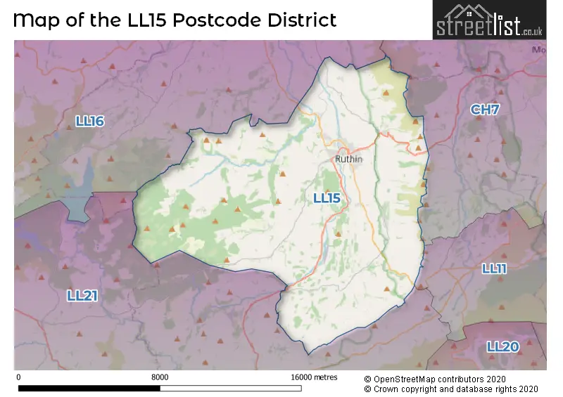
The LL15 Postcode shares a border with LL16 (DENBIGH, LLANDYRNOG, HENLLAN), CH7 (BUCKLEY, MOLD, MYNYDD ISA), LL11 (WREXHAM, GWERSYLLT, COEDPOETH) and LL21 (CORWEN, LLANDRILLO, CYNWYD).
In the LL15 postcode district, the primary settlement is Ruthin, which is located in the county of Clwyd in Wales. Additionally, there are several other significant settlements in the district including Gellifor, Llanbedr Dyffryn Clwyd, Llanbedr Hall, Llangynhafal, Llanychan, and Rhewl. All of these settlements are also located in the county of Clwyd. Ruthin is the main post town in the district with the highest number of postcodes.
For the district LL15, we have data on 3 postcode sectors. Here's a breakdown: The sector LL15 1, covers Ruthin and Llanbedr Dyffryn Clwyd in Clwyd. The sector LL15 2, covers Llanfair Dyffryn Clwyd and Llanelidan in Clwyd. The sector LL15 9 is non-geographic. It's often designated for PO Boxes, large organisations, or special services.

Map of the LL15 Postcode District
Explore the LL15 postcode district by using our free interactive map.
When it comes to local government, postal geography often disregards political borders. However, for a breakdown in the LL15 District: the district mostly encompasses the Sir Ddinbych - Denbighshire area with a total of 455 postcodes.
Recent House Sales in LL15
| Date | Price | Address |
|---|---|---|
| 20/09/2023 | £222,000 | Rhos Street, Ruthin, LL15 1DY |
| 15/09/2023 | £245,000 | Erw Goch, Ruthin, LL15 1RR |
| 12/09/2023 | £237,500 | Rhos Street, Ruthin, LL15 1DY |
| 08/09/2023 | £236,000 | The Park, Ruthin, LL15 1PW |
| 06/09/2023 | £125,000 | Mwrog Street, Ruthin, LL15 1LF |
| 29/08/2023 | £115,000 | Well Street, Ruthin, LL15 1AG |
| 23/08/2023 | £65,000 | St Peters Square, Ruthin, LL15 1DH |
| 21/08/2023 | £695,000 | Mwrog Street, Ruthin, LL15 1LG |
| 21/08/2023 | £119,000 | Bro Cloion, Clawddnewydd, Ruthin, LL15 2NW |
| 04/08/2023 | £285,000 | Denbigh Road, Ruthin, LL15 1PB |
Weather Forecast for LL15
Press Button to Show Forecast for Ruthin
| Time Period | Icon | Description | Temperature | Rain Probability | Wind |
|---|---|---|---|---|---|
| 09:00 to 12:00 | Sunny day | 8.0°C (feels like 7.0°C) | 0.00% | N 7 mph | |
| 12:00 to 15:00 | Sunny day | 10.0°C (feels like 8.0°C) | 0.00% | NNW 9 mph | |
| 15:00 to 18:00 | Sunny day | 10.0°C (feels like 7.0°C) | 0.00% | NNW 9 mph | |
| 18:00 to 21:00 | Sunny day | 8.0°C (feels like 6.0°C) | 0.00% | NNW 7 mph | |
| 21:00 to 00:00 | Clear night | 4.0°C (feels like 2.0°C) | 1.00% | WNW 4 mph |
Press Button to Show Forecast for Ruthin
| Time Period | Icon | Description | Temperature | Rain Probability | Wind |
|---|---|---|---|---|---|
| 00:00 to 03:00 | Partly cloudy (night) | 3.0°C (feels like 1.0°C) | 1.00% | SW 4 mph | |
| 03:00 to 06:00 | Cloudy | 4.0°C (feels like 2.0°C) | 5.00% | WSW 4 mph | |
| 06:00 to 09:00 | Cloudy | 6.0°C (feels like 4.0°C) | 5.00% | W 7 mph | |
| 09:00 to 12:00 | Overcast | 9.0°C (feels like 6.0°C) | 12.00% | NW 11 mph | |
| 12:00 to 15:00 | Partly cloudy (day) | 9.0°C (feels like 7.0°C) | 6.00% | NW 11 mph | |
| 15:00 to 18:00 | Cloudy | 10.0°C (feels like 7.0°C) | 6.00% | NW 9 mph | |
| 18:00 to 21:00 | Partly cloudy (day) | 9.0°C (feels like 7.0°C) | 1.00% | NNW 7 mph | |
| 21:00 to 00:00 | Cloudy | 5.0°C (feels like 4.0°C) | 6.00% | NW 4 mph |
Press Button to Show Forecast for Ruthin
| Time Period | Icon | Description | Temperature | Rain Probability | Wind |
|---|---|---|---|---|---|
| 00:00 to 03:00 | Cloudy | 5.0°C (feels like 4.0°C) | 8.00% | SSE 4 mph | |
| 03:00 to 06:00 | Cloudy | 4.0°C (feels like 2.0°C) | 10.00% | SE 4 mph | |
| 06:00 to 09:00 | Overcast | 5.0°C (feels like 3.0°C) | 16.00% | SE 4 mph | |
| 09:00 to 12:00 | Overcast | 7.0°C (feels like 5.0°C) | 16.00% | ESE 7 mph | |
| 12:00 to 15:00 | Overcast | 9.0°C (feels like 7.0°C) | 15.00% | SW 7 mph | |
| 15:00 to 18:00 | Cloudy | 10.0°C (feels like 8.0°C) | 15.00% | ENE 7 mph | |
| 18:00 to 21:00 | Cloudy | 9.0°C (feels like 7.0°C) | 15.00% | NE 7 mph | |
| 21:00 to 00:00 | Cloudy | 7.0°C (feels like 5.0°C) | 16.00% | NE 7 mph |
Press Button to Show Forecast for Ruthin
| Time Period | Icon | Description | Temperature | Rain Probability | Wind |
|---|---|---|---|---|---|
| 00:00 to 03:00 | Cloudy | 6.0°C (feels like 4.0°C) | 18.00% | E 7 mph | |
| 03:00 to 06:00 | Cloudy | 5.0°C (feels like 3.0°C) | 19.00% | NE 7 mph | |
| 06:00 to 09:00 | Cloudy | 6.0°C (feels like 4.0°C) | 18.00% | ENE 7 mph | |
| 09:00 to 12:00 | Cloudy | 8.0°C (feels like 6.0°C) | 17.00% | NE 9 mph | |
| 12:00 to 15:00 | Cloudy | 10.0°C (feels like 8.0°C) | 19.00% | NE 9 mph | |
| 15:00 to 18:00 | Cloudy | 11.0°C (feels like 9.0°C) | 20.00% | NE 9 mph | |
| 18:00 to 21:00 | Light rain shower (day) | 10.0°C (feels like 8.0°C) | 32.00% | NNE 9 mph | |
| 21:00 to 00:00 | Cloudy | 8.0°C (feels like 7.0°C) | 15.00% | N 7 mph |
Where is the LL15 Postcode District?
The LL15 postcode district is located in the town of Ruthin. It is situated near several towns, including Corwen to the south, Denbigh to the northwest, Mold to the east, Llangollen to the southeast, St. Asaph to the north, and Buckley to the northeast. The distance between LL15 and the center of London is approximately 174.621293561768 miles.
The district is within the post town of RUTHIN.
The sector has postcodes within the nation of Wales.
The LL15 Postcode District is in the Conwy and Denbighshire region of West Wales within the Wales.
| Postcode Sector | Delivery Office |
|---|---|
| LL15 1 | Ruthin Delivery Office |
| LL15 2 | Ruthin Delivery Office |
| L | L | 1 | 5 | - | X | X | X |
| L | L | 1 | 5 | Space | Numeric | Letter | Letter |
Current Monthly Rental Prices
| # Bedrooms | Min Price | Max Price | Avg Price |
|---|---|---|---|
| 1 | £525 | £525 | £525 |
| 2 | £695 | £695 | £695 |
| 3 | £1,150 | £1,150 | £1,150 |
| 6 | £2,000 | £2,000 | £2,000 |
Current House Prices
| # Bedrooms | Min Price | Max Price | Avg Price |
|---|---|---|---|
| £150,000 | £1,500,000 | £533,000 | |
| 1 | £99,950 | £174,500 | £137,225 |
| 2 | £100,000 | £335,000 | £203,248 |
| 3 | £140,000 | £595,000 | £334,323 |
| 4 | £250,000 | £795,000 | £463,698 |
| 5 | £575,000 | £950,000 | £762,500 |
| 7 | £340,000 | £925,000 | £632,500 |
Estate Agents who Operate in the LL15 District
| Logo | Name | Brand Name | Address | Contact Number | Total Properties |
|---|---|---|---|---|---|
 | Ruthin | Cavendish Estate Agents | St Peters Square Well Street, Ruthin, LL15 1AE | 01824 731180 | 36 |
 | Ruthin | Williams Estates | 16 Well Street, Ruthin, LL15 1AH | 01745 777917 | 29 |
 | covering Llandudno | Purplebricks | Suite 7 First Floor Cranmore Drive Shirley Solihull B90 4RZ | 020 3907 3310 | 4 |
 | Denbigh | Clough & Co | 45 High Street, Denbigh, LL16 3SD | 01745 777910 | 3 |
 | Denbigh | Monopoly | 15-19 High Street, Denbigh, LL16 3HY | 01745 770575 | 3 |
| Type of Property | 2018 Average | 2018 Sales | 2017 Average | 2017 Sales | 2016 Average | 2016 Sales | 2015 Average | 2015 Sales |
|---|---|---|---|---|---|---|---|---|
| Detached | £279,928 | 80 | £262,541 | 67 | £265,194 | 66 | £250,267 | 74 |
| Semi-Detached | £181,973 | 33 | £152,250 | 41 | £178,883 | 26 | £135,730 | 33 |
| Terraced | £129,688 | 29 | £141,671 | 31 | £126,733 | 30 | £129,498 | 33 |
| Flats | £100,000 | 2 | £112,800 | 5 | £150,500 | 3 | £126,500 | 6 |