The LL35 postcode district is a postal district located in the LL Llandudno postcode area with a population of 668 residents according to the 2021 England and Wales Census.
The area of the LL35 postcode district is 4.59 square miles which is 11.88 square kilometres or 2,935.04 acres.
Currently, the LL35 district has about 100 postcode units spread across 1 geographic postcode sectors.
Given that each sector allows for 400 unique postcode combinations, the district has a capacity of 400 postcodes. With 100 postcodes already in use, this leaves 300 units available.
The largest settlements in the LL35 postal code are ABERDYFI and ABERDOVEY.
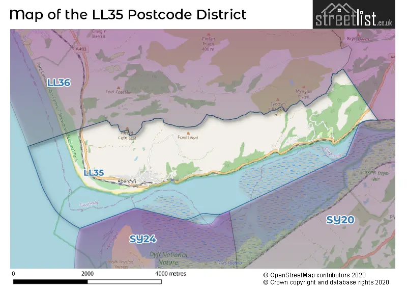
The postcode area has a boundary with Cardigan Bay.
The LL35 Postcode shares a border with LL36 (TYWYN, BRYNCRUG, LLANEGRYN).
The primary settlement in the LL35 postcode district is Aberdovey, located in Gwynedd, Wales. Aberdovey is the most significant settlement in this district, with a count of 100. No other significant settlements were mentioned in the given data. The post town for this district is also Aberdovey.
For the district LL35, we have data on 1 postcode sectors. Here's a breakdown: The sector LL35 0, covers Aberdovey in Gwynedd.
LL35 Postcode Sectors

Map of the LL35 Postcode District
Explore the LL35 postcode district by using our free interactive map.
When it comes to local government, postal geography often disregards political borders. However, for a breakdown in the LL35 District: the district mostly encompasses the Gwynedd - Gwynedd area with a total of 99 postcodes.
Recent House Sales in LL35
| Date | Price | Address |
|---|---|---|
| 18/08/2023 | £200,499 | Chapel Square, Aberdovey, LL35 0EL |
| 14/08/2023 | £167,500 | Cae Argoed, Aberdovey, LL35 0DY |
| 20/07/2023 | £280,000 | Ffordd Parc Y Llethrau, Aberdovey, LL35 0TA |
| 14/07/2023 | £275,000 | Mynydd Isaf, Aberdovey, LL35 0PH |
| 20/04/2023 | £10,000 | Plas Panteidal, Aberdovey, LL35 0RF |
| 30/03/2023 | £499,000 | Aberdovey, LL35 0RU |
| 30/03/2023 | £140,000 | Cae Argoed, Aberdovey, LL35 0DY |
| 30/03/2023 | £300,000 | Rhoslan, Aberdovey, LL35 0NS |
| 22/03/2023 | £35,000 | Plas Panteidal, Aberdovey, LL35 0RF |
| 22/03/2023 | £35,000 | Plas Panteidal, Aberdovey, LL35 0RF |
Weather Forecast for LL35
Press Button to Show Forecast for Aberdovey
| Time Period | Icon | Description | Temperature | Rain Probability | Wind |
|---|---|---|---|---|---|
| 09:00 to 12:00 | Partly cloudy (day) | 10.0°C (feels like 9.0°C) | 0.00% | NW 7 mph | |
| 12:00 to 15:00 | Cloudy | 12.0°C (feels like 10.0°C) | 5.00% | NW 11 mph | |
| 15:00 to 18:00 | Sunny day | 12.0°C (feels like 10.0°C) | 0.00% | NNW 11 mph | |
| 18:00 to 21:00 | Sunny day | 10.0°C (feels like 8.0°C) | 0.00% | NNW 11 mph | |
| 21:00 to 00:00 | Clear night | 5.0°C (feels like 4.0°C) | 1.00% | N 4 mph |
Press Button to Show Forecast for Aberdovey
| Time Period | Icon | Description | Temperature | Rain Probability | Wind |
|---|---|---|---|---|---|
| 00:00 to 03:00 | Clear night | 5.0°C (feels like 3.0°C) | 1.00% | ENE 4 mph | |
| 03:00 to 06:00 | Overcast | 6.0°C (feels like 5.0°C) | 7.00% | NE 4 mph | |
| 06:00 to 09:00 | Cloudy | 8.0°C (feels like 6.0°C) | 5.00% | WNW 7 mph | |
| 09:00 to 12:00 | Light rain shower (day) | 9.0°C (feels like 7.0°C) | 26.00% | NW 9 mph | |
| 12:00 to 15:00 | Cloudy | 10.0°C (feels like 8.0°C) | 7.00% | NW 9 mph | |
| 15:00 to 18:00 | Cloudy | 10.0°C (feels like 8.0°C) | 9.00% | WNW 9 mph | |
| 18:00 to 21:00 | Cloudy | 10.0°C (feels like 8.0°C) | 6.00% | WNW 7 mph | |
| 21:00 to 00:00 | Cloudy | 8.0°C (feels like 7.0°C) | 11.00% | WNW 4 mph |
Press Button to Show Forecast for Aberdovey
| Time Period | Icon | Description | Temperature | Rain Probability | Wind |
|---|---|---|---|---|---|
| 00:00 to 03:00 | Cloudy | 8.0°C (feels like 6.0°C) | 12.00% | N 4 mph | |
| 03:00 to 06:00 | Cloudy | 7.0°C (feels like 5.0°C) | 12.00% | ENE 7 mph | |
| 06:00 to 09:00 | Cloudy | 7.0°C (feels like 5.0°C) | 11.00% | NE 9 mph | |
| 09:00 to 12:00 | Cloudy | 8.0°C (feels like 6.0°C) | 12.00% | ENE 9 mph | |
| 12:00 to 15:00 | Overcast | 10.0°C (feels like 8.0°C) | 12.00% | SSE 9 mph | |
| 15:00 to 18:00 | Overcast | 10.0°C (feels like 9.0°C) | 18.00% | E 9 mph | |
| 18:00 to 21:00 | Cloudy | 10.0°C (feels like 8.0°C) | 13.00% | NE 9 mph | |
| 21:00 to 00:00 | Cloudy | 8.0°C (feels like 6.0°C) | 15.00% | NE 9 mph |
Press Button to Show Forecast for Aberdovey
| Time Period | Icon | Description | Temperature | Rain Probability | Wind |
|---|---|---|---|---|---|
| 00:00 to 03:00 | Cloudy | 8.0°C (feels like 5.0°C) | 12.00% | ENE 9 mph | |
| 03:00 to 06:00 | Cloudy | 7.0°C (feels like 4.0°C) | 11.00% | NE 9 mph | |
| 06:00 to 09:00 | Cloudy | 7.0°C (feels like 5.0°C) | 12.00% | ESE 11 mph | |
| 09:00 to 12:00 | Cloudy | 9.0°C (feels like 7.0°C) | 10.00% | NE 11 mph | |
| 12:00 to 15:00 | Cloudy | 11.0°C (feels like 9.0°C) | 11.00% | NE 11 mph | |
| 15:00 to 18:00 | Light rain shower (day) | 12.0°C (feels like 10.0°C) | 45.00% | NNE 11 mph | |
| 18:00 to 21:00 | Cloudy | 11.0°C (feels like 9.0°C) | 18.00% | NE 9 mph | |
| 21:00 to 00:00 | Cloudy | 9.0°C (feels like 7.0°C) | 12.00% | NNE 9 mph |
Where is the LL35 Postcode District?
The data reveals that the postcode district LL35 is located in ABERDOVEY. ABERDOVEY is situated near some other towns. To the North, there is TYWYN, which is approximately 3.11 miles away. To the East, there is ABERAERON, which is around 3.28 miles away. To the South, there is BORTH, situated around 5.81 miles away. Lastly, to the Southeast, there is TALYBONT, located approximately 6.31 miles away. Additionally, ABERDOVEY is roughly 181.07 miles away from the center of London.
The district is within the post town of ABERDOVEY.
The sector has postcodes within the nation of Wales.
The LL35 Postcode District is in the Gwynedd region of West Wales within the Wales.
Postcode Sectors within the LL35 District
Postcode Districts that Share a Border with LL35
| Postcode Sector | Delivery Office |
|---|---|
| LL35 0 | Tywyn Delivery Office |
| L | L | 3 | 5 | - | X | X | X |
| L | L | 3 | 5 | Space | Numeric | Letter | Letter |
Current Monthly Rental Prices
| # Bedrooms | Min Price | Max Price | Avg Price |
|---|
Current House Prices
| # Bedrooms | Min Price | Max Price | Avg Price |
|---|---|---|---|
| £160,000 | £160,000 | £160,000 | |
| 1 | £60,000 | £60,000 | £60,000 |
| 2 | £75,000 | £315,000 | £243,762 |
| 3 | £70,000 | £950,000 | £381,083 |
| 4 | £359,000 | £950,000 | £631,286 |
| 5 | £280,000 | £850,000 | £561,429 |
| 6 | £1,050,000 | £1,050,000 | £1,050,000 |
Estate Agents who Operate in the LL35 District
| Logo | Name | Brand Name | Address | Contact Number | Total Properties |
|---|---|---|---|---|---|
 | Tywyn | Welsh Property Services | Cambrian House High Street, Tywyn, LL36 9AE | 01654 557055 | 18 |
 | Tywyn | Morris Marshall & Poole | High Street, Tywyn, LL36 9AD | 01654 550339 | 16 |
 | Machynlleth | Morris Marshall & Poole | 18 Heol Maengwyn, Machynlleth, SY20 8DT | 01654 550338 | 3 |
 | Nationwide | Springbok Properties | Springbok Properties Nationwide Suite 7N Trafford House Chester Road Old Trafford M32 0RS | 0161 416 6302 | 1 |
 | Birmingham, Covering the Midlands | Chosen Home | Chosen Home Ltd. 3 The Courtyard, Coleshill Manor, Coleshill, West Midlands, B46 1DL. | 0121 387 6487 | 1 |
| Type of Property | 2018 Average | 2018 Sales | 2017 Average | 2017 Sales | 2016 Average | 2016 Sales | 2015 Average | 2015 Sales |
|---|---|---|---|---|---|---|---|---|
| Detached | £314,091 | 11 | £236,000 | 6 | £395,313 | 8 | £416,667 | 3 |
| Semi-Detached | £271,400 | 5 | £233,125 | 4 | £301,938 | 8 | £252,403 | 4 |
| Terraced | £294,833 | 15 | £260,583 | 12 | £248,800 | 15 | £248,529 | 17 |
| Flats | £174,083 | 6 | £194,530 | 5 | £200,000 | 5 | £172,250 | 6 |