The LL48 postcode district is a postal district located in the LL Llandudno postcode area with a population of 2,441 residents according to the 2021 England and Wales Census.
The area of the LL48 postcode district is 17.56 square miles which is 45.47 square kilometres or 11,236.69 acres.
Currently, the LL48 district has about 159 postcode units spread across 1 geographic postcode sectors.
Given that each sector allows for 400 unique postcode combinations, the district has a capacity of 400 postcodes. With 159 postcodes already in use, this leaves 241 units available.
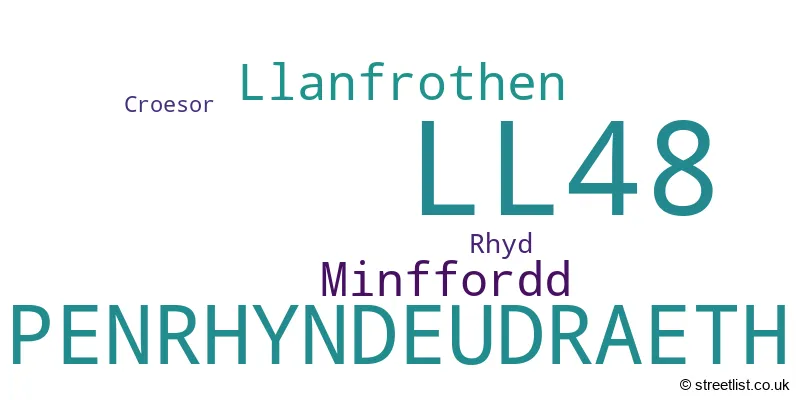
The largest settlement in the LL48 postal code is PENRHYNDEUDRAETH followed by MINFFORDD, and LLANFROTHEN.
The postcode area has a boundary with Cardigan Bay.
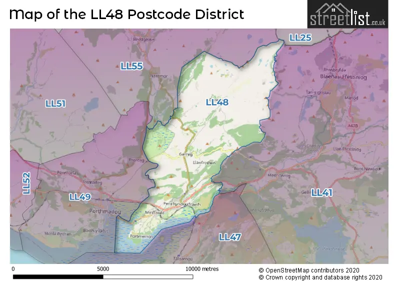
The LL48 Postcode shares a border with LL41 (BLAENAU FFESTINIOG, TRAWSFYNYDD, LLAN FFESTINIOG), LL49 (PORTHMADOG, MORFA BYCHAN, TREMADOG), LL47 (TALSARNAU, LLANDECWYN, Ynys) and LL55 (CAERNARFON, LLANBERIS, LLANRUG).
In the LL48 postcode district in Gwynedd, the primary settlement is Penrhyndeudraeth, which has the highest count. Other significant settlements in the area include Croesor, Llanfrothen, Minffordd, and Rhyd. The most significant post town in the district is Penrhyndeudraeth.
For the district LL48, we have data on 1 postcode sectors. Here's a breakdown: The sector LL48 6, covers Penrhyndeudraeth and Llanfrothen and Minffordd in Gwynedd.
LL48 Postcode Sectors

Map of the LL48 Postcode District
Explore the LL48 postcode district by using our free interactive map.
When it comes to local government, postal geography often disregards political borders. However, for a breakdown in the LL48 District: the district mostly encompasses the Gwynedd - Gwynedd area with a total of 159 postcodes.
Recent House Sales in LL48
| Date | Price | Address |
|---|---|---|
| 29/09/2023 | £126,500 | Glanllyn, Penrhyndeudraeth, LL48 6BS |
| 22/09/2023 | £395,000 | Minffordd, Penrhyndeudraeth, LL48 6EH |
| 08/09/2023 | £197,000 | Osmond Terrace, Penrhyndeudraeth, LL48 6PA |
| 18/08/2023 | £200,000 | Osmond Terrace, Penrhyndeudraeth, LL48 6PA |
| 18/08/2023 | £160,000 | Bwlch Goleu, Penrhyndeudraeth, LL48 6DP |
| 28/07/2023 | £125,000 | Bryn Islwyn, Penrhyndeudraeth, LL48 6BB |
| 24/07/2023 | £177,000 | Minffordd, Penrhyndeudraeth, LL48 6HN |
| 14/06/2023 | £120,000 | Penlan Terrace, Penrhyndeudraeth, LL48 6BY |
| 14/06/2023 | £245,000 | Highgate, Penrhyndeudraeth, LL48 6RG |
| 26/05/2023 | £150,000 | Bwlch Goleu, Penrhyndeudraeth, LL48 6DP |
Weather Forecast for LL48
Press Button to Show Forecast for Moelwyn Mawr
| Time Period | Icon | Description | Temperature | Rain Probability | Wind |
|---|---|---|---|---|---|
| 21:00 to 00:00 | Clear night | 3.0°C (feels like -2.0°C) | 0.00% | N 13 mph |
Press Button to Show Forecast for Moelwyn Mawr
| Time Period | Icon | Description | Temperature | Rain Probability | Wind |
|---|---|---|---|---|---|
| 00:00 to 03:00 | Cloudy | 2.0°C (feels like -3.0°C) | 3.00% | NNW 16 mph | |
| 03:00 to 06:00 | Cloudy | 2.0°C (feels like -3.0°C) | 4.00% | NW 13 mph | |
| 06:00 to 09:00 | Cloudy | 2.0°C (feels like -2.0°C) | 13.00% | N 11 mph | |
| 09:00 to 12:00 | Partly cloudy (day) | 3.0°C (feels like -2.0°C) | 0.00% | NNE 11 mph | |
| 12:00 to 15:00 | Sunny day | 4.0°C (feels like 0.0°C) | 0.00% | NNE 13 mph | |
| 15:00 to 18:00 | Sunny day | 4.0°C (feels like 0.0°C) | 0.00% | N 11 mph | |
| 18:00 to 21:00 | Sunny day | 3.0°C (feels like -1.0°C) | 0.00% | N 9 mph | |
| 21:00 to 00:00 | Clear night | 1.0°C (feels like -3.0°C) | 1.00% | NNW 11 mph |
Press Button to Show Forecast for Moelwyn Mawr
| Time Period | Icon | Description | Temperature | Rain Probability | Wind |
|---|---|---|---|---|---|
| 00:00 to 03:00 | Clear night | 0.0°C (feels like -5.0°C) | 1.00% | W 13 mph | |
| 03:00 to 06:00 | Cloudy | 0.0°C (feels like -5.0°C) | 5.00% | W 11 mph | |
| 06:00 to 09:00 | Cloudy | 1.0°C (feels like -4.0°C) | 10.00% | W 13 mph | |
| 09:00 to 12:00 | Overcast | 2.0°C (feels like -2.0°C) | 10.00% | NW 11 mph | |
| 12:00 to 15:00 | Overcast | 3.0°C (feels like -1.0°C) | 12.00% | NW 11 mph | |
| 15:00 to 18:00 | Cloudy | 4.0°C (feels like 0.0°C) | 9.00% | NW 11 mph | |
| 18:00 to 21:00 | Cloudy | 3.0°C (feels like 0.0°C) | 7.00% | NW 7 mph | |
| 21:00 to 00:00 | Cloudy | 1.0°C (feels like -2.0°C) | 10.00% | WNW 7 mph |
Press Button to Show Forecast for Moelwyn Mawr
| Time Period | Icon | Description | Temperature | Rain Probability | Wind |
|---|---|---|---|---|---|
| 00:00 to 03:00 | Cloudy | 0.0°C (feels like -3.0°C) | 12.00% | S 7 mph | |
| 03:00 to 06:00 | Light snow | 0.0°C (feels like -5.0°C) | 47.00% | ESE 9 mph | |
| 06:00 to 09:00 | Overcast | 0.0°C (feels like -5.0°C) | 14.00% | ESE 11 mph | |
| 09:00 to 12:00 | Cloudy | 2.0°C (feels like -3.0°C) | 12.00% | E 11 mph | |
| 12:00 to 15:00 | Overcast | 3.0°C (feels like -1.0°C) | 15.00% | SSE 11 mph | |
| 15:00 to 18:00 | Overcast | 3.0°C (feels like -1.0°C) | 21.00% | SSE 11 mph | |
| 18:00 to 21:00 | Cloudy | 2.0°C (feels like -2.0°C) | 19.00% | NE 11 mph | |
| 21:00 to 00:00 | Cloudy | 1.0°C (feels like -4.0°C) | 14.00% | ESE 13 mph |
Press Button to Show Forecast for Moelwyn Mawr
| Time Period | Icon | Description | Temperature | Rain Probability | Wind |
|---|---|---|---|---|---|
| 00:00 to 03:00 | Cloudy | 0.0°C (feels like -5.0°C) | 14.00% | ESE 13 mph | |
| 03:00 to 06:00 | Overcast | 0.0°C (feels like -6.0°C) | 18.00% | ENE 13 mph | |
| 06:00 to 09:00 | Cloudy | 0.0°C (feels like -5.0°C) | 19.00% | ENE 13 mph | |
| 09:00 to 12:00 | Cloudy | 2.0°C (feels like -2.0°C) | 18.00% | E 13 mph | |
| 12:00 to 15:00 | Overcast | 4.0°C (feels like 0.0°C) | 17.00% | E 13 mph | |
| 15:00 to 18:00 | Light rain shower (day) | 5.0°C (feels like 1.0°C) | 36.00% | NE 13 mph | |
| 18:00 to 21:00 | Light rain shower (day) | 4.0°C (feels like -1.0°C) | 37.00% | NE 13 mph | |
| 21:00 to 00:00 | Cloudy | 2.0°C (feels like -3.0°C) | 14.00% | NE 16 mph |
Where is the LL48 Postcode District?
The LL48 postcode district is located in Penrhyndeudraeth. Penrhyndeudraeth is a district town that is situated near several other towns in different directions. To the south, there is Talsarnau, located 4.3 miles away. To the east, there is Blaenau Ffestiniog, situated 4.5 miles away. To the southwest, there is Porthmadog, which is approximately 4.8 miles away. To the west, there is Criccieth, located 7.6 miles away. Lastly, to the northeast, there is Dolwyddelan, which is approximately 10 miles away. The LL48 postcode district is also around 194.5 miles away from the center of London.
The district is within the post town of PENRHYNDEUDRAETH.
The sector has postcodes within the nation of Wales.
The LL48 Postcode District is in the Gwynedd region of West Wales within the Wales.
Postcode Sectors within the LL48 District
| Postcode Sector | Delivery Office |
|---|---|
| LL48 6 | Porthmadog Delivery Office |
| L | L | 4 | 8 | - | X | X | X |
| L | L | 4 | 8 | Space | Numeric | Letter | Letter |
Tourist Attractions within the Postcode Area
We found 1 visitor attractions within the LL48 postcode area
| Portmeirion |
|---|
| View Portmeirion on Google Maps |
Current Monthly Rental Prices
| # Bedrooms | Min Price | Max Price | Avg Price |
|---|
Current House Prices
| # Bedrooms | Min Price | Max Price | Avg Price |
|---|---|---|---|
| £275,000 | £850,000 | £562,500 | |
| 2 | £65,000 | £220,000 | £151,421 |
| 3 | £160,000 | £275,000 | £208,333 |
| 4 | £150,000 | £395,995 | £255,999 |
Estate Agents who Operate in the LL48 District
| Logo | Name | Brand Name | Address | Contact Number | Total Properties |
|---|---|---|---|---|---|
 | Porthmadog | Tom Parry & Co | 80 High Street, Porthmadog, LL49 9NW | 01766 807994 | 8 |
 | Porthmadog | Beresford Adams | 148 High Street Porthmadog LL49 9NU | 01766 800884 | 8 |
 | Porthmadog | Bob Parry | 134 High Street, Porthmadog, Gwynedd, LL49 9NW | 01766 800822 | 2 |
 | Pwllheli | Tudor Estate Agents | Plas Y Ward, Y Maes, Pwllheli, LL53 5DA | 01758 658967 | 2 |
 | Aberystwyth | Fine and Country West Wales | The Gallery Station Approach Alexandra Road, Aberystwyth, SY23 1LH | 01954 776006 | 1 |
| Type of Property | 2018 Average | 2018 Sales | 2017 Average | 2017 Sales | 2016 Average | 2016 Sales | 2015 Average | 2015 Sales |
|---|---|---|---|---|---|---|---|---|
| Detached | £188,375 | 8 | £219,818 | 11 | £204,636 | 11 | £236,653 | 16 |
| Semi-Detached | £158,000 | 5 | £134,240 | 5 | £126,483 | 3 | £109,983 | 3 |
| Terraced | £108,419 | 13 | £96,456 | 28 | £82,911 | 14 | £93,200 | 15 |
| Flats | £0 | 0 | £0 | 0 | £0 | 0 | £0 | 0 |