The LL64 postcode district is a postal district located in the LL Llandudno postcode area with a population of 780 residents according to the 2021 England and Wales Census.
The area of the LL64 postcode district is 1.02 square miles which is 2.65 square kilometres or 655.37 acres.
Currently, the LL64 district has about 58 postcode units spread across 1 geographic postcode sectors.
Given that each sector allows for 400 unique postcode combinations, the district has a capacity of 400 postcodes. With 58 postcodes already in use, this leaves 342 units available.
The LL64 postal code covers the settlement of RHOSNEIGR.
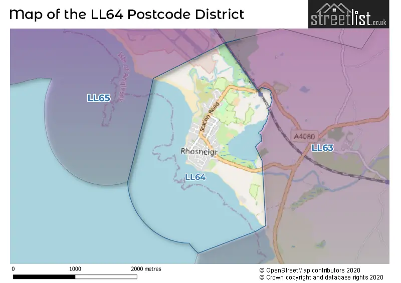
The postcode area has a boundary with Caernarfon Bay.
The LL64 Postcode shares a border with LL63 (TY CROES, ABERFFRAW, LLANFAELOG) and LL65 (HOLYHEAD, TREARDDUR BAY, VALLEY).
The primary settlement in the LL64 postcode district is Rhosneigr, located in Gwynedd, Wales. It is the most significant settlement with the highest count in this postcode district.
For the district LL64, we have data on 1 postcode sectors. Here's a breakdown: The sector LL64 5, covers Rhosneigr in Gwynedd.
LL64 Postcode Sectors

Map of the LL64 Postcode District
Explore the LL64 postcode district by using our free interactive map.
When it comes to local government, postal geography often disregards political borders. However, for a breakdown in the LL64 District: the district mostly encompasses the Sir Ynys Mon - Isle of Anglesey area with a total of 58 postcodes.
Recent House Sales in LL64
| Date | Price | Address |
|---|---|---|
| 08/09/2023 | £900,000 | Overstrand Avenue, Rhosneigr, LL64 5QQ |
| 21/08/2023 | £560,825 | Ffordd Y Wylan, Rhosneigr, LL64 5QH |
| 10/08/2023 | £385,000 | Ger Y Mor, Rhosneigr, LL64 5JF |
| 04/08/2023 | £2,000,000 | Porth Crigyll, Rhosneigr, LL64 5RB |
| 28/07/2023 | £680,000 | Sandy Lane, Rhosneigr, LL64 5QF |
| 12/07/2023 | £320,000 | Sisial Y Mor, Rhosneigr, LL64 5XB |
| 25/05/2023 | £535,000 | Ladys Walk, Rhosneigr, LL64 5JU |
| 25/05/2023 | £320,000 | Sandy Lane, Rhosneigr, LL64 5QF |
| 19/05/2023 | £970,000 | High Street, Rhosneigr, LL64 5UX |
| 26/04/2023 | £550,000 | Ger Y Mor, Rhosneigr, LL64 5JF |
Weather Forecast for LL64
Press Button to Show Forecast for Rhosneigr - Traeth Crigyll (Beach)
| Time Period | Icon | Description | Temperature | Rain Probability | Wind |
|---|---|---|---|---|---|
| 18:00 to 21:00 | Sunny day | 9.0°C (feels like 7.0°C) | 0.00% | N 7 mph | |
| 21:00 to 00:00 | Clear night | 5.0°C (feels like 3.0°C) | 1.00% | NNE 4 mph |
Press Button to Show Forecast for Rhosneigr - Traeth Crigyll (Beach)
| Time Period | Icon | Description | Temperature | Rain Probability | Wind |
|---|---|---|---|---|---|
| 00:00 to 03:00 | Clear night | 4.0°C (feels like 2.0°C) | 1.00% | ENE 4 mph | |
| 03:00 to 06:00 | Partly cloudy (night) | 3.0°C (feels like 0.0°C) | 1.00% | ENE 7 mph | |
| 06:00 to 09:00 | Sunny day | 5.0°C (feels like 2.0°C) | 2.00% | ENE 7 mph | |
| 09:00 to 12:00 | Partly cloudy (day) | 9.0°C (feels like 6.0°C) | 4.00% | ENE 9 mph | |
| 12:00 to 15:00 | Cloudy | 9.0°C (feels like 7.0°C) | 6.00% | N 11 mph | |
| 15:00 to 18:00 | Sunny day | 9.0°C (feels like 7.0°C) | 4.00% | NE 9 mph | |
| 18:00 to 21:00 | Sunny day | 8.0°C (feels like 6.0°C) | 2.00% | NE 9 mph | |
| 21:00 to 00:00 | Clear night | 5.0°C (feels like 3.0°C) | 3.00% | NE 7 mph |
Press Button to Show Forecast for Rhosneigr - Traeth Crigyll (Beach)
| Time Period | Icon | Description | Temperature | Rain Probability | Wind |
|---|---|---|---|---|---|
| 00:00 to 03:00 | Clear night | 5.0°C (feels like 2.0°C) | 3.00% | NE 7 mph | |
| 03:00 to 06:00 | Partly cloudy (night) | 4.0°C (feels like 2.0°C) | 3.00% | ENE 7 mph | |
| 06:00 to 09:00 | Partly cloudy (day) | 5.0°C (feels like 3.0°C) | 3.00% | ENE 7 mph | |
| 09:00 to 12:00 | Partly cloudy (day) | 9.0°C (feels like 7.0°C) | 8.00% | ENE 9 mph | |
| 12:00 to 15:00 | Cloudy | 10.0°C (feels like 8.0°C) | 10.00% | NE 9 mph | |
| 15:00 to 18:00 | Partly cloudy (day) | 10.0°C (feels like 8.0°C) | 8.00% | NE 11 mph | |
| 18:00 to 21:00 | Partly cloudy (day) | 9.0°C (feels like 7.0°C) | 5.00% | NE 11 mph | |
| 21:00 to 00:00 | Partly cloudy (night) | 8.0°C (feels like 5.0°C) | 7.00% | NNE 11 mph |
Press Button to Show Forecast for Rhosneigr - Traeth Crigyll (Beach)
| Time Period | Icon | Description | Temperature | Rain Probability | Wind |
|---|---|---|---|---|---|
| 00:00 to 03:00 | Cloudy | 7.0°C (feels like 4.0°C) | 13.00% | NE 11 mph | |
| 03:00 to 06:00 | Cloudy | 7.0°C (feels like 4.0°C) | 13.00% | NNE 11 mph | |
| 06:00 to 09:00 | Cloudy | 8.0°C (feels like 5.0°C) | 13.00% | NNE 13 mph | |
| 09:00 to 12:00 | Cloudy | 9.0°C (feels like 6.0°C) | 15.00% | NNE 13 mph | |
| 12:00 to 15:00 | Partly cloudy (day) | 10.0°C (feels like 7.0°C) | 9.00% | N 13 mph | |
| 15:00 to 18:00 | Partly cloudy (day) | 11.0°C (feels like 8.0°C) | 7.00% | NNW 13 mph | |
| 18:00 to 21:00 | Sunny day | 10.0°C (feels like 8.0°C) | 7.00% | NW 9 mph | |
| 21:00 to 00:00 | Clear night | 8.0°C (feels like 6.0°C) | 6.00% | W 9 mph |
Where is the LL64 Postcode District?
The LL64 postcode district is located in the town of Rhosneigr. Rhosneigr is situated near several nearby towns, including Ty Croes to the East (2.09 miles away), Bodorgan to the South East (5.14 miles away), Holyhead to the North West (7.44 miles away), and Llannerch-y-Medd to the North East (8.55 miles away). Additionally, Rhosneigr is approximately 220.47 miles away from the centre of London.
The district is within the post town of RHOSNEIGR.
The sector has postcodes within the nation of Wales.
The LL64 Postcode District is in the Isle of Anglesey region of West Wales within the Wales.
Postcode Sectors within the LL64 District
| Postcode Sector | Delivery Office |
|---|---|
| LL64 5 | Llangefni Delivery Office |
| L | L | 6 | 4 | - | X | X | X |
| L | L | 6 | 4 | Space | Numeric | Letter | Letter |
Current Monthly Rental Prices
| # Bedrooms | Min Price | Max Price | Avg Price |
|---|---|---|---|
| 4 | £2,300 | £2,300 | £2,300 |
Current House Prices
| # Bedrooms | Min Price | Max Price | Avg Price |
|---|---|---|---|
| 2 | £290,000 | £500,000 | £366,667 |
| 3 | £265,000 | £900,000 | £557,600 |
| 4 | £380,000 | £1,950,000 | £881,000 |
| 5 | £515,000 | £599,950 | £557,475 |
| 9 | £895,000 | £895,000 | £895,000 |
Estate Agents who Operate in the LL64 District
| Logo | Name | Brand Name | Address | Contact Number | Total Properties |
|---|---|---|---|---|---|
 | Rhosneigr | Rhosneigr Property | 1 Beach Terrace, Rhosneigr, LL64 5QB | 01407 880161 | 6 |
 | Llangefni | Williams & Goodwin The Property People | 21 & 23 Church Street, Llangefni, LL77 7DU | 01248 663139 | 4 |
 | Llangefni | Dafydd Hardy | 3 Sgwar Bulkeley Llangefni Ynys M�n LL77 7LR | 01248 661234 | 2 |
 | Holyhead | Beresford Adams | 7-9 Market Street Holyhead LL65 1UL | 01407 880631 | 2 |
 | Alderley Edge | Andrew J Nowell | 8 London Road, Alderley Edge, SK9 7JS | 01625 920670 | 1 |
| Type of Property | 2018 Average | 2018 Sales | 2017 Average | 2017 Sales | 2016 Average | 2016 Sales | 2015 Average | 2015 Sales |
|---|---|---|---|---|---|---|---|---|
| Detached | £505,814 | 11 | £300,038 | 13 | £351,188 | 16 | £378,634 | 20 |
| Semi-Detached | £306,875 | 4 | £277,857 | 7 | £268,750 | 4 | £244,000 | 6 |
| Terraced | £0 | 0 | £347,500 | 5 | £196,375 | 4 | £335,018 | 8 |
| Flats | £360,000 | 3 | £175,590 | 5 | £417,000 | 3 | £181,938 | 8 |