The LL71 postcode district is a postal district located in the LL Llandudno postcode area with a population of 1,895 residents according to the 2021 England and Wales Census.
The area of the LL71 postcode district is 21.70 square miles which is 56.20 square kilometres or 13,887.28 acres.
Currently, the LL71 district has about 84 postcode units spread across 2 geographic postcode sectors.
Given that each sector allows for 400 unique postcode combinations, the district has a capacity of 800 postcodes. With 84 postcodes already in use, this leaves 716 units available.
The largest settlement in the LL71 postal code is LLANERCHYMEDD followed by LLANDYFRYDOG, and CARMEL.
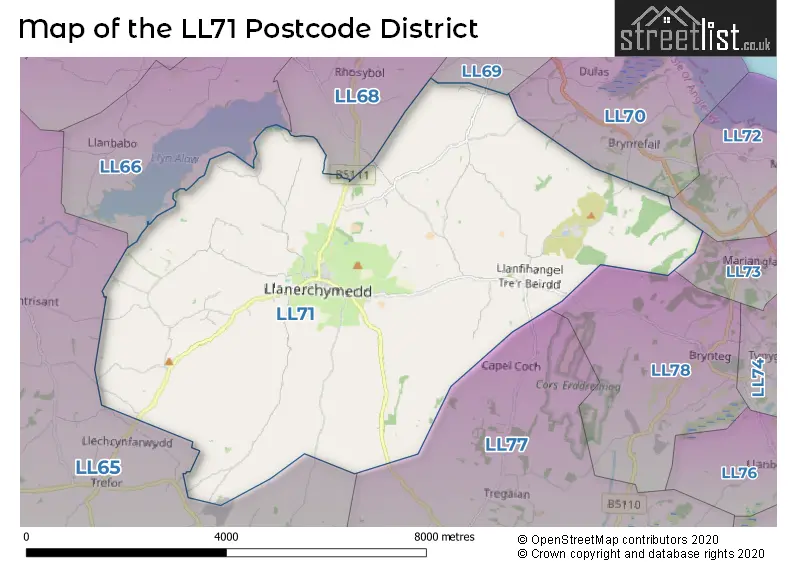
The LL71 Postcode shares a border with LL78 (BRYNTEG, LLANBEDRGOCH), LL68 (AMLWCH, LLANFECHELL, BULL BAY), LL66 (RHOSGOCH, CARREGLEFN, AMLWCH) and LL65 (HOLYHEAD, TREARDDUR BAY, VALLEY).
The primary settlement in the LL71 postcode district is Llanerch-y-Medd, located in Gwynedd, Wales. Other significant settlements in the district include Carmel and Llandrygan. The most significant post town in this district is also Llanerch-y-Medd.
For the district LL71, we have data on 2 postcode sectors. Here's a breakdown: The sector LL71 7, covers Llannerch-Y-Medd and Carmel and Llandrygan in Gwynedd. The sector LL71 8, covers Llannerch-Y-Medd and Llandyfrydog and Mynydd Bodafon in Gwynedd.

Map of the LL71 Postcode District
Explore the LL71 postcode district by using our free interactive map.
When it comes to local government, postal geography often disregards political borders. However, for a breakdown in the LL71 District: the district mostly encompasses the Sir Ynys Mon - Isle of Anglesey area with a total of 85 postcodes.
Recent House Sales in LL71
| Date | Price | Address |
|---|---|---|
| 18/08/2023 | £104,000 | Bridge Street, Llannerch-y-medd, LL71 8EU |
| 07/08/2023 | £300,000 | Llandyfrydog, Llannerch-y-medd, LL71 8AS |
| 28/06/2023 | £148,000 | Y Garth, Llannerch-y-medd, LL71 7BD |
| 12/05/2023 | £220,000 | Carmel, Llannerch-y-medd, LL71 7DH |
| 26/04/2023 | £185,000 | Pencraigwen, Llannerch-y-medd, LL71 8AT |
| 16/03/2023 | £118,000 | Maes Athen, Llannerch-y-medd, LL71 8DL |
| 31/01/2023 | £430,000 | Lon Coedana, Coedana, Llannerch-y-medd, LL71 8AA |
| 02/12/2022 | £210,000 | Farmer Street, Llannerch-y-medd, LL71 8DT |
| 30/11/2022 | £352,000 | Coedana, Llannerch-y-medd, LL71 8EW |
| 11/11/2022 | £630,000 | Carmel, Llannerch-y-medd, LL71 7BU |
Weather Forecast for LL71
Press Button to Show Forecast for Traeth Lligwy (Beach)
| Time Period | Icon | Description | Temperature | Rain Probability | Wind |
|---|---|---|---|---|---|
| 12:00 to 15:00 | Cloudy | 9.0°C (feels like 6.0°C) | 12.00% | N 11 mph | |
| 15:00 to 18:00 | Sunny day | 9.0°C (feels like 7.0°C) | 2.00% | N 9 mph | |
| 18:00 to 21:00 | Sunny day | 9.0°C (feels like 7.0°C) | 0.00% | N 7 mph | |
| 21:00 to 00:00 | Clear night | 6.0°C (feels like 4.0°C) | 32.00% | N 4 mph |
Press Button to Show Forecast for Traeth Lligwy (Beach)
| Time Period | Icon | Description | Temperature | Rain Probability | Wind |
|---|---|---|---|---|---|
| 00:00 to 03:00 | Clear night | 5.0°C (feels like 3.0°C) | 1.00% | ENE 7 mph | |
| 03:00 to 06:00 | Partly cloudy (night) | 6.0°C (feels like 3.0°C) | 1.00% | E 9 mph | |
| 06:00 to 09:00 | Partly cloudy (day) | 6.0°C (feels like 3.0°C) | 8.00% | ENE 9 mph | |
| 09:00 to 12:00 | Light rain shower (day) | 8.0°C (feels like 6.0°C) | 32.00% | ENE 9 mph | |
| 12:00 to 15:00 | Sunny day | 9.0°C (feels like 6.0°C) | 4.00% | NE 11 mph | |
| 15:00 to 18:00 | Partly cloudy (day) | 9.0°C (feels like 7.0°C) | 4.00% | NE 9 mph | |
| 18:00 to 21:00 | Sunny day | 8.0°C (feels like 6.0°C) | 2.00% | NE 9 mph | |
| 21:00 to 00:00 | Clear night | 6.0°C (feels like 4.0°C) | 3.00% | NE 9 mph |
Press Button to Show Forecast for Traeth Lligwy (Beach)
| Time Period | Icon | Description | Temperature | Rain Probability | Wind |
|---|---|---|---|---|---|
| 00:00 to 03:00 | Partly cloudy (night) | 6.0°C (feels like 3.0°C) | 4.00% | ENE 9 mph | |
| 03:00 to 06:00 | Clear night | 5.0°C (feels like 3.0°C) | 3.00% | ENE 7 mph | |
| 06:00 to 09:00 | Partly cloudy (day) | 6.0°C (feels like 4.0°C) | 3.00% | ENE 9 mph | |
| 09:00 to 12:00 | Partly cloudy (day) | 9.0°C (feels like 6.0°C) | 8.00% | ENE 9 mph | |
| 12:00 to 15:00 | Cloudy | 10.0°C (feels like 8.0°C) | 10.00% | NE 9 mph | |
| 15:00 to 18:00 | Partly cloudy (day) | 10.0°C (feels like 7.0°C) | 8.00% | NE 11 mph | |
| 18:00 to 21:00 | Partly cloudy (day) | 9.0°C (feels like 6.0°C) | 6.00% | NE 11 mph | |
| 21:00 to 00:00 | Cloudy | 8.0°C (feels like 5.0°C) | 9.00% | NE 11 mph |
Press Button to Show Forecast for Traeth Lligwy (Beach)
| Time Period | Icon | Description | Temperature | Rain Probability | Wind |
|---|---|---|---|---|---|
| 00:00 to 03:00 | Cloudy | 8.0°C (feels like 5.0°C) | 13.00% | NE 13 mph | |
| 03:00 to 06:00 | Partly cloudy (night) | 7.0°C (feels like 4.0°C) | 11.00% | NE 13 mph | |
| 06:00 to 09:00 | Cloudy | 8.0°C (feels like 5.0°C) | 13.00% | NNE 13 mph | |
| 09:00 to 12:00 | Cloudy | 9.0°C (feels like 6.0°C) | 15.00% | NNE 16 mph | |
| 12:00 to 15:00 | Partly cloudy (day) | 10.0°C (feels like 7.0°C) | 9.00% | N 13 mph | |
| 15:00 to 18:00 | Partly cloudy (day) | 11.0°C (feels like 8.0°C) | 8.00% | NNW 13 mph | |
| 18:00 to 21:00 | Sunny day | 10.0°C (feels like 8.0°C) | 7.00% | NW 9 mph | |
| 21:00 to 00:00 | Partly cloudy (night) | 8.0°C (feels like 5.0°C) | 6.00% | W 9 mph |
Where is the LL71 Postcode District?
The LL71 postcode district is located in Llannerch-y-Medd, a district town in Wales. It is situated near several towns, such as Brynteg, Penysarn, Rhosgoch, Amlwch, and Llanbedrgoch. It is approximately 218.89 miles away from the center of London.
The district is within the post town of LLANNERCH-Y-MEDD.
The sector has postcodes within the nation of Wales.
The LL71 Postcode District is in the Isle of Anglesey region of West Wales within the Wales.
| Postcode Sector | Delivery Office |
|---|---|
| LL71 7 | Llangefni Delivery Office |
| LL71 8 | Llangefni Delivery Office |
| L | L | 7 | 1 | - | X | X | X |
| L | L | 7 | 1 | Space | Numeric | Letter | Letter |
Current Monthly Rental Prices
| # Bedrooms | Min Price | Max Price | Avg Price |
|---|
Current House Prices
| # Bedrooms | Min Price | Max Price | Avg Price |
|---|---|---|---|
| £140,000 | £140,000 | £140,000 | |
| 2 | £99,950 | £259,995 | £168,315 |
| 3 | £89,950 | £325,000 | £222,136 |
| 4 | £250,000 | £695,000 | £531,667 |
| 5 | £585,000 | £585,000 | £585,000 |
| 6 | £550,000 | £1,850,000 | £1,200,000 |
Estate Agents who Operate in the LL71 District
| Logo | Name | Brand Name | Address | Contact Number | Total Properties |
|---|---|---|---|---|---|
 | Llangefni | Williams & Goodwin The Property People | 21 & 23 Church Street, Llangefni, LL77 7DU | 01248 663139 | 3 |
 | Llangefni | Dafydd Hardy | 3 Sgwar Bulkeley Llangefni Ynys M�n LL77 7LR | 01248 661234 | 3 |
 | Llangefni | Morgan Evans and Co | 28-30 Church Street, Llangefni, LL77 7DU | 01248 665487 | 2 |
 | covering Llandudno | Purplebricks | Suite 7 First Floor Cranmore Drive Shirley Solihull B90 4RZ | 020 3907 3310 | 2 |
 | Menai Bridge | Lucas Estate Agents | 22 High Street, Menai Bridge, LL59 5EE | 01248 663117 | 1 |
| Type of Property | 2018 Average | 2018 Sales | 2017 Average | 2017 Sales | 2016 Average | 2016 Sales | 2015 Average | 2015 Sales |
|---|---|---|---|---|---|---|---|---|
| Detached | £238,872 | 16 | £230,797 | 17 | £201,578 | 18 | £183,545 | 11 |
| Semi-Detached | £154,390 | 5 | £147,000 | 2 | £77,400 | 5 | £161,333 | 3 |
| Terraced | £93,786 | 7 | £97,556 | 8 | £79,750 | 4 | £89,833 | 3 |
| Flats | £0 | 0 | £0 | 0 | £0 | 0 | £0 | 0 |