This section of the site is all about the LN Postcode area, also known as the Lincoln Postal Area. Explore links to the next level to learn more about specific postcode districts such as LN1.
The LN postcode area represents a group of postal districts in the Lincoln area of the United Kingdom. The area code LN stands for the letters l and n in LincolN. LN has a population of 293,310 and covers an area of 2,523,652 hectares. Fun fact: 0.45% of the population of Great Britain lives in this area.
The postcode area falls within the following counties: Lincolnshire (99.98%), Nottinghamshire (0.02%).
Post Towns and Postcode Districts for the LN Postcode
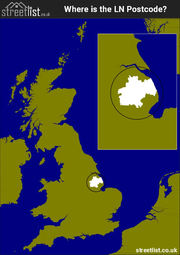
Where is the LN Postcode Area?
The LN Lincoln Postcode is in the East Midlands of England. The postal area borders the following neighbouring postal areas: PE - Peterborough, NG - Nottingham and DN - Doncaster, It also borders The North Sea,
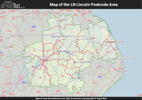
Map of the LN Lincoln Postcode Area
Explore the LN Lincoln postcode area by using our interactive map.
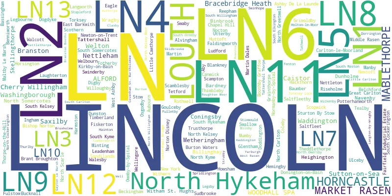
Postcode Districts within the LN Lincoln Postcode Area
There are 13 postcode districts within the Lincoln postcode area
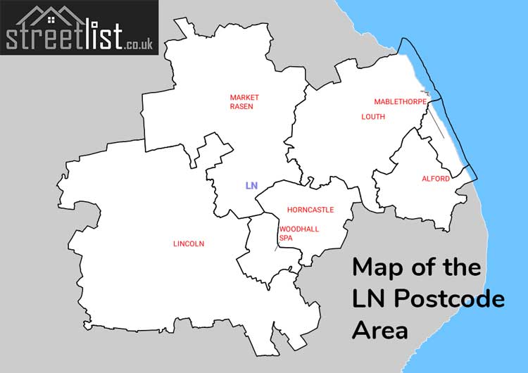
A map showing the boundary of in relation to other areas
There are 7 towns within the Lincoln postcode area.
| Unit | Area² |
|---|---|
| Hectares | 2,523,652² |
| Miles | 9,744² |
| Feet | 271,643,377,628² |
| Kilometres | 25,237² |
Postal Delivery Offices serving the LN Lincoln Postcode Area
- Alford (ln) Delivery Office
- Bardney Scale Payment Delivery Office
- Billinghay Scale Payment Delivery Office
- Coningsby Scale Payment Delivery Office
- Digby Scale Payment Delivery Office
- Eagle Scale Payment Delivery Office
- Horncastle Delivery Office
- Lincoln Delivery Office
- Louth Delivery Office
- Mablethorpe Delivery Office
- Market Rasen Delivery Office
- Metheringham Scale Payment Delivery Office
- Navenby Scale Payment Delivery Office
- Nocton Scale Payment Delivery Office
- Saxilby Scale Payment Delivery Office
- Skellingthorpe Scale Payment Delivery Office
- Timberland Scale Payment Delivery Office
- Welbourn Scale Payment Delivery Office
- Welton Scale Payment Delivery Office
- Woodhall Spa Scale Payment Delivery Office
Councils with Postcodes in LN
Towns and Villages within the LN Lincoln Postcode Area
- Aby - village
- Alford - village
- Alvingham - village
- Asterby - otherSettlement
- Aubourn - village
- Authorpe - village
- Bardney - village
- Bassingham - village
- Baumber - village
- Beckingham - village
- Beesby - village
- Belchford - village
- Benniworth - village
- Billinghay - village
- Bilsby - village
- Binbrook - village
- Bishop Norton - village
- Blankney - village
- Boothby Graffoe - village
- Bracebridge Heath - village
- Brampton - otherSettlement
- Branston - village
- Branston Booths - village
- Brant Broughton - village
- Brinkhill - village
- Broadholme - otherSettlement
- Brookenby - village
- Broxholme - otherSettlement
- Bucknall - village
- Burgh on Bain - village
- Burton Waters - village
- Burton-by-Lincoln - village
- Caenby Corner - otherSettlement
- Caistor - village
- Cammeringham - village
- Canwick - village
- Carlton-le-Moorland - village
- Chapel Hill - village
- Cherry Willingham - village
- Claxby - village
- Coleby - village
- Coningsby - village
- Conisholme - otherSettlement
- Covenham St Bartholomew - village
- Covenham St Mary - village
- Cumberworth - village
- Digby - village
- Doddington - village
- Dogdyke - village
- Donington on Bain - village
- Dorrington - village
- Dunholme - village
- Dunston - village
- Eagle - village
- Eagle Moor - village
- East Barkwith - village
- Faldingworth - village
- Fenton - village
- Fiskerton - village
- Fotherby - village
- Fulletby - village
- Fulstow - village
- Gayton le Marsh - village
- Glentham - village
- Goulceby - village
- Grainthorpe - village
- Grange de Lings - otherSettlement
- Great Carlton - village
- Greetham - otherSettlement
- Grimoldby - village
- Hackthorn - village
- Hainton - village
- Haltham - village
- Harmston - village
- Hawthorn Hill - village
- Heighington - village
- Hemingby - village
- Holland Fen - village
- Holton cum Beckering - village
- Holton le Moor - village
- Horncastle - town
- Horsington - village
- Howsham - village
- Huttoft - village
- Ingham - village
- Keddington - otherSettlement
- Kirkby Green - village
- Kirkby on Bain - village
- Laneham - village
- Langworth - village
- Laughterton - village
- Leadenham - village
- Legbourne - village
- Lincoln - city
- Little Carlton - village
- Little Cawthorpe - village
- Louth - town
- Ludford - village
- Mablethorpe - town
- Maltby le Marsh - village
- Manby - village
- Market Rasen - town
- Martin - village
- Martin Dales - village
- Metheringham - village
- Middle Rasen - village
- Minting - village
- Moortown - village
- Mumby - village
- Navenby - village
- Nettleham - village
- Nettleton - village
- New York - village
- Newtoft - village
- Newton on Trent - village
- Nocton - village
- Normanby le Wold - otherSettlement
- Normanby-by-Spital - village
- North Carlton - village
- North Cockerington - village
- North Greetwell - village
- North Hykeham - town
- North Kelsey - village
- North Kelsey Moor - village
- North Kyme - village
- North Owersby - village
- North Scarle - village
- North Somercotes - otherSettlement
- Norton Disney - village
- Osgodby - village
- Owmby-by-Spital - village
- Potterhanworth - village
- Reepham - village
- Riseholme - village
- Rothwell - village
- Rowston - village
- Saleby - village
- Saltfleet - village
- Saltfleetby All Saints - village
- Saltfleetby St Peter - village
- Sandilands - village
- Saxilby - village
- Scamblesby - village
- Scampton - village
- Scopwick - village
- Scothern - village
- Scrub Hill - village
- Skellingthorpe - village
- Skidbrooke - otherSettlement
- Sloothby - village
- Snelland - village
- South Carlton - village
- South Cockerington - village
- South Elkington - village
- South Hykeham - village
- South Kelsey - village
- South Kyme - village
- South Ormsby - otherSettlement
- South Reston - village
- South Somercotes - village
- South Willingham - village
- Southrey - village
- Spridlington - village
- Stainfield - otherSettlement
- Stapleford - village
- Stenigot - otherSettlement
- Stewton - otherSettlement
- Stow - village
- Strubby - village
- Sturton by Stow - village
- Sudbrooke - village
- Sutton on Sea - village
- Swaby - village
- Swallow - village
- Swinderby - village
- Tathwell - village
- Tattershall - village
- Tattershall Bridge - village
- Tattershall Thorpe - village
- Tealby - village
- Tetford - village
- Theddlethorpe St Helen - village
- Thimbleby - village
- Thorpe - otherSettlement
- Thorpe on the Hill - village
- Thurlby - otherSettlement
- Thurlby - otherSettlement
- Timberland - village
- Torksey - village
- Torksey Lock - village
- Trusthorpe - village
- Ulceby - village
- Utterby - village
- Waddington - village
- Walcott - village
- Walesby - village
- Washingborough - village
- Welbourn - village
- Wellingore - village
- Welton - village
- West Ashby - village
- West Rasen - otherSettlement
- Whisby - village
- Wickenby - village
- Willoughby - village
- Witham St Hughs - village
- Withern - village
- Woodhall Spa - town
- Wragby - town
- Yarburgh - village